| |
| Capital |
Currency | Government system |
|---|
| New Delhi |
Indian Rupee (INR) |
Parliamentary democracy |
| Official language | Region |
Population |
|---|
Hindi
English |
South Asia |
Estimation 2020 - 1 371 360 200 |
Country map - Administrative structure - Population density of India
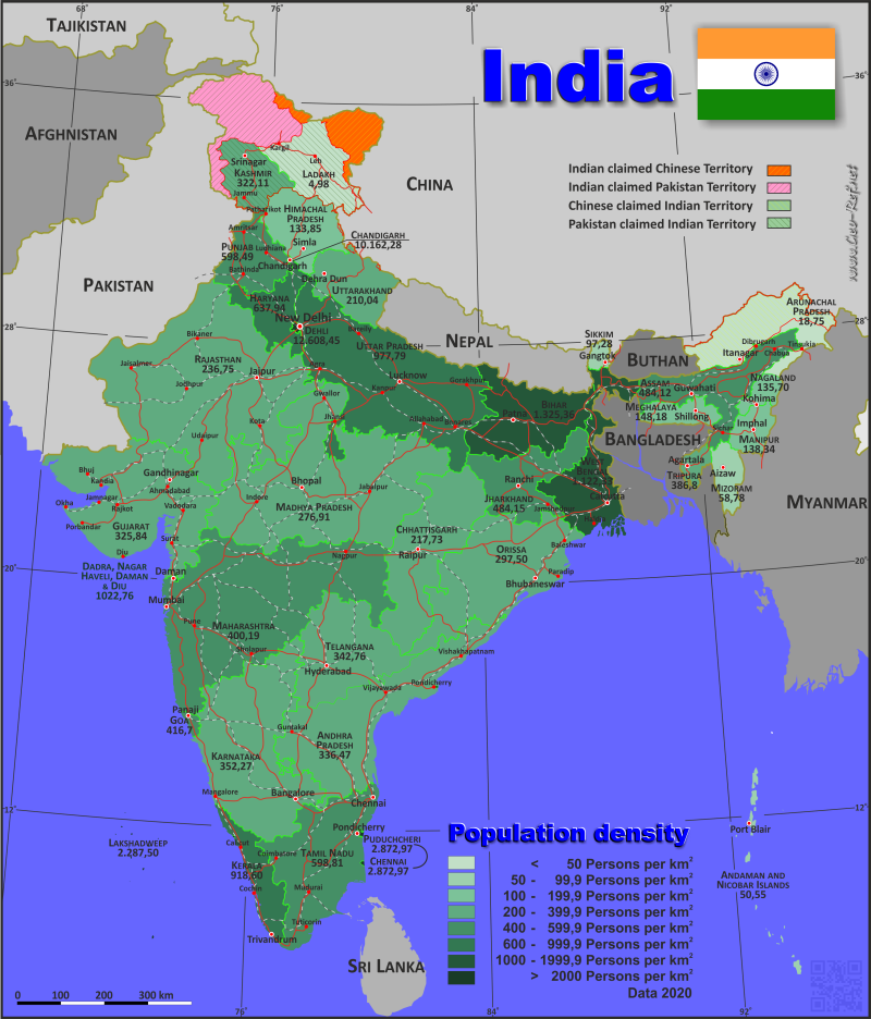
India - Click on the map to get a enlarged image in PDF format!
Other language versions are easy to generate, the description is in an own layer
Conditions for thematic maps with your own data and logotype
Delivery as printable file by e-mail or plot by post office |
|---|
| Layer | |
| Province: | yes |
| Streets: | yes |
| Infrastructure: | yes |
| Rivers: | yes |
|
| Size | bis A2 |
| Supply in | 7 working days |
| Price |
| 1 bis 3 | 70 € |
| > 3 | On request |
|
 |
| Observation |
Territorial disputes marked. Only administrative structure |
All information published herein is free usable quoting the source,
including the maps, if they are not modified |
|---|
Statistical Data - Population density according to the administrative structure
The population data in the table below is an estimation for 2020, based on the census data from 2011.
Click on the column header brings the table in order of the column header. The default order is the State/Territory name.
| State/Territory |
ISO
3166-2 |
Status |
Capital |
Area
(km²) |
Population |
Density
(pers/km²) |
|---|
| Total |
|
|
|
3 164 428 |
1 371 360 200 |
433,37 |
|---|
| Last update: 11/04/2020 - 00:43:47 |
| State / Territory |
ISO |
Status |
Capital |
Área |
Populación |
Densidad |
| Andaman & Nicobar Islands |
IN-AN |
Union territories |
Port Blair |
8 250 |
417 000 |
50,55 |
| Andhra Pradesh |
IN-AP |
State |
Amaravati |
160 205 |
53 903 400 |
336,47 |
| Arunachal Pradesh |
IN-AR |
State |
Itanagar |
83 743 |
1 570 500 |
18,75 |
| Assam |
IN-AS |
State |
Dispur |
73 550 |
35 607 000 |
484,12 |
| Bihar |
IN-BR |
State |
Patna |
94 163 |
124 799 900 |
1 325,36 |
| Capital Territory of Delhi |
IN-DL |
Union territories |
- |
1 484 |
18 710 900 |
12 608,42 |
| Chandigarh |
IN-CH |
Union territories |
Chandigarh |
114 |
1 158 500 |
10 162,28 |
| Chhattisgarh |
IN-CT |
State |
Raipur |
135 194 |
29 436 200 |
217,73 |
| Dadra & Nagar Haveli |
IN-DN |
Union territories |
Silvassa |
602 |
615 700 |
1 022,76 |
| Goa |
IN-GA |
State |
Panaji |
3 702 |
1 586 300 |
428,50 |
| Gujarat |
IN-GJ |
State |
Gandhinagar |
196 024 |
63 872 400 |
325,84 |
| Haryana |
IN-HR |
State |
Chandigarh |
44 212 |
28 204 700 |
637,94 |
| Himachal Pradesh |
IN-HP |
State |
Shimla |
55 673 |
7 452 000 |
133,85 |
| Jammu & Kashmir |
IN-JK |
State |
Jammu (winter) /Srinagar (summer) |
42 241 |
13 606 300 |
322,11 |
| Jharkhand |
IN-JH |
State |
Ranchi |
79 714 |
38 593 900 |
484,15 |
| Karnataka |
IN-KA |
State |
Bangalore |
191 791 |
67 562 700 |
352,27 |
| Kerala |
IN-KL |
State |
Thiruvananthapuram |
38 863 |
35 699 400 |
918,60 |
| Ladakh |
IN-LA |
Union territories |
Leh |
59 146 |
289 000 |
4,89 |
| Lakshadweep |
IN-LD |
Union territories |
Kavaratti |
32 |
73 200 |
2 287,50 |
| Madhya Pradesh |
IN-MP |
State |
Bhopal |
308 252 |
85 359 000 |
276,91 |
| Maharashtra |
IN-MH |
State |
Mumbai |
307 713 |
123 144 200 |
400,19 |
| Manipur |
IN-MN |
State |
Imphal |
22 347 |
3 091 500 |
138,34 |
| Meghalaya |
IN-ML |
State |
Shillong |
22 720 |
3 366 700 |
148,18 |
| Mizoram |
IN-MZ |
State |
Aizawl |
21 081 |
1 239 200 |
58,78 |
| Nagaland |
IN-NL |
State |
Kohima |
16 579 |
2 249 700 |
135,70 |
| Orissa |
IN-OR |
State |
Bhubaneswar |
155 820 |
46 356 300 |
297,50 |
| Pondicherry |
IN-PY |
Union territories |
Pondicherry |
492 |
1 413 500 |
2 872,97 |
| Punjab |
IN-PB |
State |
Chandigarh |
50 362 |
30 141 400 |
598,49 |
| Rajasthan |
IN-RJ |
State |
Jaipur |
342 269 |
81 032 700 |
236,75 |
| Sikkim |
IN-SK |
State |
Gangtok |
7 096 |
690 300 |
97,28 |
| Tamil Nadu |
IN-TN |
State |
Chennai |
130 058 |
77 841 300 |
598,51 |
| Telangana |
IN-TG |
State |
Hyderabad |
114 840 |
39 362 700 |
342,76 |
| Tripura |
IN-TR |
State |
Agartala |
10 492 |
4 169 800 |
397,43 |
| Uttar Pradesh |
IN-UP |
State |
Lucknow |
243 286 |
237 882 700 |
977,79 |
| Uttarakhand |
IN-UL |
State |
Dehradun |
53 566 |
11 250 900 |
210,04 |
| West Bengal |
IN-WB |
State |
Kolkata |
88 752 |
99 609 300 |
1 122,33 |
Membership in international organisations and treaties
Expand list
Political Alliances
Regional Unions
Military alliances/Arms control
Law enforcement
Business Alliances
Fishery
Financial
Free Trade Area, Internal Market
Technical alliances
Environment
Transport
Cientific
Humanitarian Unions
Cultural Unions
 |
If you have suggestions to include other information or you find missed links, please inform us!
Click here ... |
International Border disputes
Expand list
Land boundaries
Maritime boundaries
|
Fast selection
List of international
organisations
and treaties
Existing
thematical maps
|
