| |
Islamic Republic of Pakistan
|
| Capital |
Currency | Government system |
|---|
| Islamabad |
Rupia Pakistaní PKR |
Parliamentary democracy |
| Official language | Region |
Population |
|---|
Urdu
English |
South Asia |
Census 2023 - 246 516 395 |
Country map - Administrative structure - Population density of Pakistan
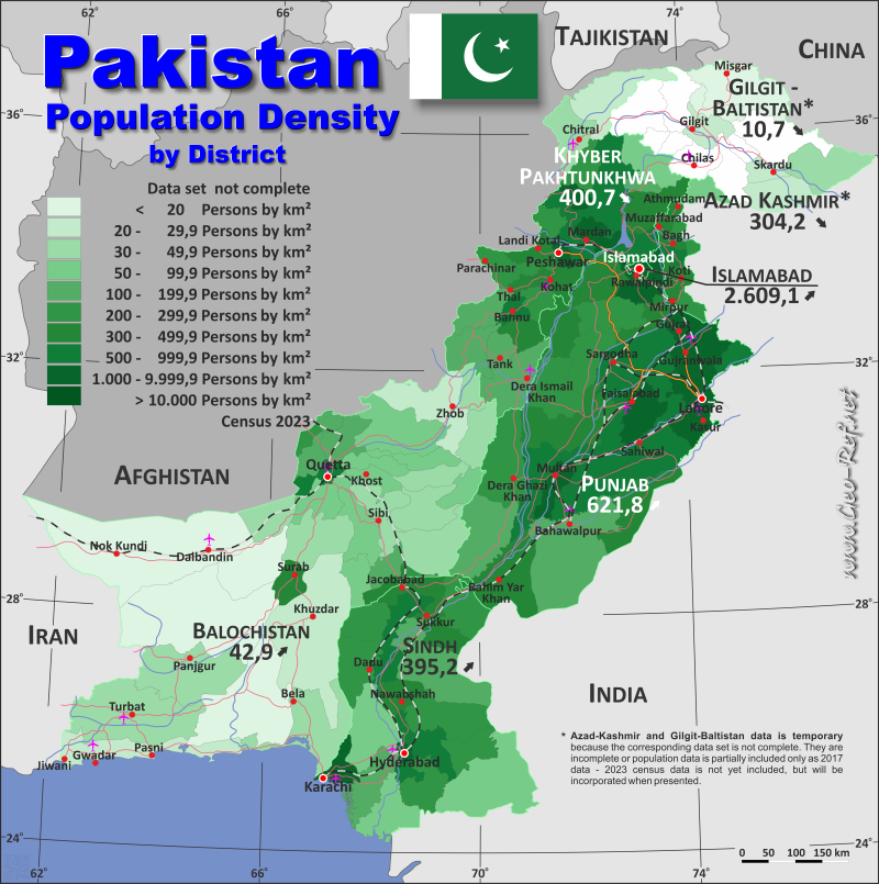
Pakistan - Click on the map to get a enlarged image in PDF format!
Other language versions are easy to generate, the description is in an own layer
Conditions for thematic maps with your own data and logotype
Delivery as printable file by e-mail or plot by post office |
|---|
| Layer | |
| Province: | yes |
| Streets: | yes |
| Infrastructure: | yes |
| Rivers: | yes |
|
| Size | bis A2 |
| Supply in | 7 working days |
| Price |
| 1 bis 3 | 60 € |
| > 3 | On request |
|
 |
All information published herein is free usable quoting the source,
including the maps, if they are not modified |
|---|
Statistical Data - Population density according to the administrative structure
The population data in the table below is the census data from 2023, last available data.
Click on the column header brings the table in order of the column header. The default order is the Province name.
| Province |
ISO
3166-2 |
Urdu |
Capital |
Area
(km²) |
Population |
Density
(pers/km²) |
|---|
| Total |
|
|
|
900 448 |
246 516 395 |
273,8 |
|---|
| Last update: 11/04/2020 - 00:43:48 |
| Azad Kashmir |
PK-JK |
آزاد کشمیر |
Muzaffarabad |
13 297 |
4 045 366 |
304,2 |
| Balochistan (province) |
PK-BA |
بلوچستان |
Quetta |
347 118 |
14 894 402 |
42,9 |
| Gilgit–Baltistan |
PK-NA |
گلگت - بلتستان གིལྒིཏ་བལྟིསྟནگل |
Gilgit |
90 896 |
971 598 |
10,7 |
| Islamabad Capital Territory |
PK-IS |
وفاقی دارالحکومت |
Islamabad |
906 |
2 363 863 |
2 609,1 |
| Khyber Pakhtunkhwa(province) |
PK-NW |
خیبرپختونخوا |
Peshawar |
101 972 |
40 856 097 |
400,7 |
| Punjab (province) |
PK-PB |
پنجاب |
Lahore |
205 345 |
127 688 922 |
621,8 |
| Sindh (province) |
PK-SD |
سنڌ سندھ |
Karachi |
140 914 |
55 696 147 |
395,2 |
The provinces are divided into
districts, the data of which are shown in the
table below.
Azad-Kashmir and Gilgit-Baltistan data is
temporary because the corresponding data set is
not complete. They are incomplete or population
data is partially included only as 2017 data -
2023 census data is not yet included, but will be
incorporated when presented.
| District |
Own |
Province |
Capital |
Area
(km²) |
Population |
Density
(pers/km²) |
|---|
| Total |
|
|
|
900 448 |
246 516 395 |
273,8 |
|---|
| Last update: 11/04/2020 - 00:43:48 |
| Abbottabad |
NW-01 |
Khyber Pakhtunkhwa |
Abbottabad |
1 967 |
1 419 072 |
721,4 |
| Astore |
NA-01 |
Gilgit-Baltistan |
Eidghah |
5092 |
n d |
- |
| Attock |
PB-01 |
Punjab |
Attock |
6 857 |
2 170 423 |
316,5 |
| Awaran |
BA-01 |
Balochistan |
Awaran |
29 510 |
178 958 |
6,1 |
| Badin |
SD-01 |
Sindh |
Badin |
6 858 |
1 947 081 |
283,9 |
| Bagh |
JK-01 |
Azad Kashmir |
Bagh |
768 |
371 919 |
484,3 |
| Bahawalnagar |
PB-02 |
Punjab |
Bahawalnagar |
8 878 |
3 550 342 |
399,9 |
| Bahawalpur |
PB-03 |
Punjab |
Bahawalpur |
24 830 |
4 284 964 |
172,6 |
| Bajaur |
NW-02 |
Khyber Pakhtunkhwa |
Khaar |
1 290 |
1 287 960 |
998,4 |
| Bannu |
NW-03 |
Khyber Pakhtunkhwa |
Bannu |
1 972 |
1 357 890 |
688,6 |
| Barkhan |
BA-02 |
Balochistan |
Barkhan |
3 514 |
210 249 |
59,8 |
| Batagram |
NW-04 |
Khyber Pakhtunkhwa |
Daggar |
1 227 |
554 133 |
451,6 |
| Bhakkar |
PB-04 |
Punjab |
Bhakkar |
8 153 |
1 957 470 |
240,1 |
| Bhimber |
JK-02 |
Azad Kashmir |
Bhimber |
1516 |
420 624 |
277,5 |
| Buner |
NW-05 |
Khyber Pakhtunkhwa |
Daggar |
1 301 |
1 016 869 |
781,6 |
| Chagai |
BA-03 |
Balochistan |
Dalbandin |
44 748 |
269 192 |
6,0 |
| Chakwal |
PB-05 |
Punjab |
Chakwal |
6 525 |
1 734 854 |
265,9 |
| Chaman |
BA-04 |
Balochistan |
Chaman |
1 341 |
466 218 |
347,7 |
| Charsadda |
NW-06 |
Khyber Pakhtunkhwa |
Charsadda |
1 865 |
1 835 504 |
984,2 |
| Chiniot |
PB-06 |
Punjab |
Chiniot |
2 643 |
1 563 024 |
591,4 |
| Dadu |
SD-02 |
Sindh |
Dadu |
7 866 |
1 742 320 |
221,5 |
| Darel |
NA-02 |
Gilgit-Baltistan |
Darel |
n d |
n d |
- |
| Dera Bugti |
BA-05 |
Balochistan |
Dera Bugti |
10 160 |
355 274 |
35,0 |
| Dera Ghazi Khan |
PB-07 |
Punjab |
Dera Ghazi Khan |
11 922 |
3 393 705 |
284,7 |
| Dera Ismail Khan |
NW-07 |
Khyber Pakhtunkhwa |
Dera Ismail Khan |
9 334 |
1 829 811 |
196,0 |
| Diamer |
NA-03 |
Gilgit-Baltistan |
Chilas |
10936 |
n d |
- |
| Duki |
BA-06 |
Balochistan |
Duki |
4 233 |
205 044 |
48,4 |
| Faisalabad |
PB-08 |
Punjab |
Faisalabad |
5 857 |
9 075 819 |
1 549,6 |
| Ghanche |
NA-04 |
Gilgit-Baltistan |
Khaplu |
4052 |
160 000 |
39,5 |
| Ghizer |
NA-05 |
Gilgit-Baltistan |
Gahkuch |
9635 |
n d |
- |
| Ghotki |
SD-03 |
Sindh |
Ghotki |
6 083 |
1 772 609 |
291,4 |
| Gilgit |
NA-06 |
Gilgit-Baltistan |
Gilgit |
14672 |
330 000 |
22,5 |
| Gujranwala |
PB-09 |
Punjab |
Gujranwala |
3 622 |
5 959 750 |
1 645,4 |
| Gujrat |
PB-10 |
Punjab |
Gujrat |
3 192 |
3 219 375 |
1 008,6 |
| Gupis-Yasin |
NA-07 |
Gilgit-Baltistan |
Phander |
n d |
n d |
- |
| Gwadar |
BA-07 |
Balochistan |
Gwadar |
12 637 |
305 160 |
24,1 |
| Hafizabad |
PB-11 |
Punjab |
Hafizabad |
2 367 |
1 319 909 |
557,6 |
| Hangu |
NW-08 |
Khyber Pakhtunkhwa |
Hangu |
1 097 |
528 902 |
482,1 |
| Haripur |
NW-09 |
Khyber Pakhtunkhwa |
Haripur |
1 725 |
1 174 783 |
681,0 |
| Harnai |
BA-08 |
Balochistan |
Harnai |
2 492 |
127 571 |
51,2 |
| Hatian Bala |
JK-03 |
Azad Kashmir |
Hatian Bala |
854 |
230 529 |
269,9 |
| Haveli |
JK-04 |
Azad Kashmir |
Forward Kahuta |
600 |
152 124 |
253,5 |
| Hunza |
NA-08 |
Gilgit-Baltistan |
Aliabad |
7900 |
70 000 |
8,9 |
| Hyderabad |
SD-04 |
Sindh |
Hyderabad |
993 |
2 432 540 |
2 449,7 |
| Islamabad |
IS-01 |
Islamabad |
Islamabad |
906 |
2 363 863 |
2 609,1 |
| Jacobabad |
SD-05 |
Sindh |
Jacobabad |
2 698 |
1 174 097 |
435,2 |
| Jaffarabad |
BA-09 |
Balochistan |
Dera Allah Yar |
1 643 |
594 558 |
361,9 |
| Jamshoro |
SD-06 |
Sindh |
Jamshoro |
11 204 |
1 117 308 |
99,7 |
| Jhal Magsi |
BA-10 |
Balochistan |
Jhal Magsi |
3 615 |
203 368 |
56,3 |
| Jhang |
PB-12 |
Punjab |
Jhang |
6 166 |
3 077 720 |
499,1 |
| Jhelum |
PB-13 |
Punjab |
Jhelum |
3 587 |
1 382 308 |
385,4 |
| Kachhi |
BA-11 |
Balochistan |
Dhadar |
5 682 |
442 612 |
77,9 |
| Kalat |
BA-12 |
Balochistan |
Kalat |
7 654 |
272 506 |
35,6 |
| Karachi Central |
SD-07 |
Sindh |
Karachi |
69 |
3 822 325 |
55 396,0 |
| Karachi East |
SD-08 |
Sindh |
Karachi |
139 |
3 950 031 |
28 417,5 |
| Karachi South |
SD-09 |
Sindh |
Karachi |
122 |
2 329 764 |
19 096,4 |
| Karachi West |
SD-10 |
Sindh |
Karachi |
370 |
2 679 380 |
7 241,6 |
| Karak |
NW-10 |
Khyber Pakhtunkhwa |
Karak |
3 371 |
815 878 |
242,0 |
| Kashmore |
SD-11 |
Sindh |
Kashmore |
2 580 |
1 233 957 |
478,3 |
| Kasur |
PB-14 |
Punjab |
Kasur |
3 995 |
4 084 286 |
1 022,3 |
| Keamari |
SD-12 |
Sindh |
Keamari |
559 |
2 068 451 |
3 700,3 |
| Kech |
BA-13 |
Balochistan |
Turbat |
22 539 |
1 060 931 |
47,1 |
| Khairpur |
SD-13 |
Sindh |
Khairpur |
15 910 |
2 597 535 |
163,3 |
| Khanewal |
PB-15 |
Punjab |
Khanewal |
4 349 |
3 364 077 |
773,5 |
| Kharan |
BA-14 |
Balochistan |
Kharan |
14 958 |
260 352 |
17,4 |
| Kharmang |
NA-09 |
Gilgit-Baltistan |
Tolti |
7909 |
188 000 |
23,8 |
| Khushab |
PB-16 |
Punjab |
Jauharabad |
6 511 |
1 501 089 |
230,5 |
| Khuzdar |
BA-15 |
Balochistan |
Khuzdar |
35 380 |
997 214 |
28,2 |
| Khyber |
NW-11 |
Khyber Pakhtunkhwa |
Landi Kotal |
2 576 |
1 146 267 |
445,0 |
| Killa Abdullah |
BA-16 |
Balochistan |
Killa Abdullah |
3 553 |
361 971 |
101,9 |
| Killa Saifullah |
BA-17 |
Balochistan |
Killa Saifullah |
6 831 |
380 200 |
55,7 |
| Kohat |
NW-12 |
Khyber Pakhtunkhwa |
Kohat |
2 991 |
1 234 661 |
412,8 |
| Kohlu |
BA-18 |
Balochistan |
Kohlu |
7 610 |
260 220 |
34,2 |
| Kolai-Palas |
NW-13 |
Khyber Pakhtunkhwa |
Kolai-Palas |
1 410 |
280 162 |
198,7 |
| Korangi |
SD-14 |
Sindh |
Karachi |
108 |
3 128 971 |
28 972,0 |
| Kotli |
JK-05 |
Azad Kashmir |
Kotli |
1862 |
774 194 |
415,8 |
| Kurram |
NW-14 |
Khyber Pakhtunkhwa |
Parachinar |
3 380 |
785 434 |
232,4 |
| Lahore |
PB-17 |
Punjab |
Lahore |
1 772 |
13 004 135 |
7 338,7 |
| Lakki Marwat |
NW-15 |
Khyber Pakhtunkhwa |
Lakki Marwat |
3 296 |
1 040 856 |
315,8 |
| Larkana |
SD-15 |
Sindh |
Larkana |
1 948 |
1 784 453 |
916,0 |
| Lasbela |
BA-19 |
Balochistan |
Uthal |
15 153 |
680 977 |
44,9 |
| Layyah |
PB-18 |
Punjab |
Layyah |
6 289 |
2 102 386 |
334,3 |
| Lodhran |
PB-19 |
Punjab |
Lodhran |
2 778 |
1 928 299 |
694,1 |
| Loralai |
BA-20 |
Balochistan |
Loralai |
3 785 |
272 432 |
72,0 |
| Lower Chitral |
NW-16 |
Khyber Pakhtunkhwa |
Chitral |
6 458 |
320 407 |
49,6 |
| Lower Dir |
NW-17 |
Khyber Pakhtunkhwa |
Timergara |
1 583 |
1 650 183 |
1 042,4 |
| Lower Kohistan |
NW-18 |
Khyber Pakhtunkhwa |
Pattan |
642 |
340 017 |
529,6 |
| Malakand Protected Area |
NW-19 |
Khyber Pakhtunkhwa |
Batkhela |
952 |
826 250 |
867,9 |
| Malir |
SD-16 |
Sindh |
Malir |
2 160 |
2 403 959 |
1 112,9 |
| Mandi Bahauddin |
PB-20 |
Punjab |
Mandi Bahauddin |
2 673 |
1 829 486 |
684,4 |
| Mansehra |
NW-20 |
Khyber Pakhtunkhwa |
Mansehra |
4 125 |
1 797 177 |
435,7 |
| Mardan |
NW-21 |
Khyber Pakhtunkhwa |
Mardan |
1 632 |
2 744 898 |
1 681,9 |
| Mastung |
BA-21 |
Balochistan |
Mastung |
3 308 |
313 271 |
94,7 |
| Matiari |
SD-17 |
Sindh |
Matiari |
1 417 |
849 383 |
599,4 |
| Mianwali |
PB-21 |
Punjab |
Mianwali |
5 840 |
1 798 268 |
307,9 |
| Mirpur |
JK-06 |
Azad Kashmir |
Mirpur |
1010 |
456 200 |
451,7 |
| Mirpur Khas |
SD-18 |
Sindh |
Mirpur Khas |
2 925 |
1 681 386 |
574,8 |
| Mohmand |
NW-22 |
Khyber Pakhtunkhwa |
Ghallanay |
2 296 |
553 933 |
241,3 |
| Multan |
PB-22 |
Punjab |
Multan |
3 720 |
5 362 305 |
1 441,5 |
| Musakhel |
BA-22 |
Balochistan |
Musakhel |
5 728 |
182 275 |
31,8 |
| Muzaffarabad |
JK-07 |
Azad Kashmir |
Muzaffarabad |
1642 |
650 370 |
396,1 |
| Muzaffargarh |
PB-23 |
Punjab |
Muzaffargarh |
8 249 |
5 015 325 |
608,0 |
| Nagar |
NA-10 |
Gilgit-Baltistan |
Nagar |
5000 |
8 750 |
1,8 |
| Nankana Sahib |
PB-24 |
Punjab |
Nankana Sahib |
2 216 |
1 634 871 |
737,8 |
| Narowal |
PB-25 |
Punjab |
Narowal |
2 337 |
1 950 954 |
834,8 |
| Nasirabad |
BA-23 |
Balochistan |
Dera Murad Jamali |
3 387 |
563 377 |
166,3 |
| Naushahro Feroze |
SD-19 |
Sindh |
Naushahro Feroze |
2 946 |
1 777 082 |
603,2 |
| Neelam Valley |
JK-08 |
Azad Kashmir |
Athmuqam |
3621 |
191 251 |
52,8 |
| North Waziristan |
NW-23 |
Khyber Pakhtunkhwa |
Miranshah |
4 707 |
693 332 |
147,3 |
| Nowshera |
NW-24 |
Khyber Pakhtunkhwa |
Nowshera |
1 748 |
1 740 705 |
995,8 |
| Nushki |
BA-24 |
Balochistan |
Nushki |
5 797 |
207 834 |
35,9 |
| Okara |
PB-26 |
Punjab |
Okara |
4 377 |
3 515 490 |
803,2 |
| Orakzai |
NW-25 |
Khyber Pakhtunkhwa |
Kalaya |
1 538 |
387 561 |
252,0 |
| Pakpattan |
PB-27 |
Punjab |
Pakpattan |
2 724 |
2 136 170 |
784,2 |
| Panjgur |
BA-25 |
Balochistan |
Chitken |
16 819 |
509 781 |
30,3 |
| Peshawar |
NW-26 |
Khyber Pakhtunkhwa |
Peshawar |
1 518 |
4 758 762 |
3 134,9 |
| Pishin |
BA-26 |
Balochistan |
Pishin |
6 218 |
835 482 |
134,4 |
| Poonch |
JK-09 |
Azad Kashmir |
Rawalakot |
855 |
500 571 |
585,5 |
| Qambar Shahdadkot |
SD-20 |
Sindh |
Qambar |
5 475 |
1 514 869 |
276,7 |
| Quetta |
BA-27 |
Balochistan |
Quetta |
3 447 |
2 595 492 |
753,0 |
| Rahim Yar Khan |
PB-28 |
Punjab |
Rahim Yar Khan |
11 880 |
5 564 703 |
468,4 |
| Rajanpur |
PB-29 |
Punjab |
Rajanpur |
12 318 |
2 381 049 |
193,3 |
| Rawalpindi |
PB-30 |
Punjab |
Rawalpindi |
5 285 |
6 118 911 |
1 157,8 |
| Rondu |
NA-11 |
Gilgit-Baltistan |
Dambudas |
8500 |
n d |
- |
| Sahiwal |
PB-31 |
Punjab |
Sahiwal |
3 201 |
2 881 811 |
900,3 |
| Sanghar |
SD-21 |
Sindh |
Sanghar |
10 728 |
2 308 465 |
215,2 |
| Sargodha |
PB-32 |
Punjab |
Sargodha |
5 856 |
4 334 448 |
740,2 |
| Shaheed Benazir Abad |
SD-22 |
Sindh |
Nawabshah |
4 502 |
1 845 102 |
409,8 |
| Shangla |
NW-27 |
Khyber Pakhtunkhwa |
Alpuri |
1 586 |
891 252 |
561,9 |
| Sheerani |
BA-28 |
Balochistan |
Sheerani |
4 310 |
191 687 |
44,5 |
| Sheikhupura |
PB-33 |
Punjab |
Sheikhupura |
3 744 |
4 049 418 |
1 081,6 |
| Shigar |
NA-12 |
Gilgit-Baltistan |
Shigar |
8500 |
n d |
- |
| Shikarpur |
SD-23 |
Sindh |
Shikarpur |
2 512 |
1 386 330 |
551,9 |
| Sialkot |
PB-34 |
Punjab |
Sialkot |
3 016 |
4 499 394 |
1 491,8 |
| Sibi |
BA-29 |
Balochistan |
Sibi |
7 121 |
224 148 |
31,5 |
| Skardu |
NA-13 |
Gilgit-Baltistan |
Skardu |
8700 |
214 848 |
24,7 |
| Sohbatpur |
BA-30 |
Balochistan |
Sohbatpur |
802 |
240 106 |
299,4 |
| South Waziristan |
NW-28 |
Khyber Pakhtunkhwa |
Wana |
6 620 |
888 675 |
134,2 |
| Sudhnoti |
JK-10 |
Azad Kashmir |
Palandri |
569 |
297 584 |
523,0 |
| Sujawal |
SD-24 |
Sindh |
Sujawal |
8 785 |
839 292 |
95,5 |
| Sukkur |
SD-25 |
Sindh |
Sukkur |
5 165 |
1 639 897 |
317,5 |
| Surab |
BA-31 |
Balochistan |
Surab |
762 |
278 092 |
365,0 |
| Swabi |
NW-29 |
Khyber Pakhtunkhwa |
Swabi |
1 543 |
1 894 600 |
1 227,9 |
| Swat |
NW-30 |
Khyber Pakhtunkhwa |
Swat |
5 337 |
2 687 384 |
503,5 |
| Tando Allahyar |
SD-26 |
Sindh |
Tando Allahyar |
1 554 |
922 012 |
593,3 |
| Tando Muhammad Khan |
SD-27 |
Sindh |
Tando Muhammad Khan |
1 423 |
726 119 |
510,3 |
| Tangir |
NA-14 |
Gilgit-Baltistan |
Tangir |
n d |
n d |
- |
| Tank |
NW-31 |
Khyber Pakhtunkhwa |
Tank |
2 900 |
470 293 |
162,2 |
| Tharparkar |
SD-28 |
Sindh |
Mithi |
19 637 |
1 778 407 |
90,6 |
| Thatta |
SD-29 |
Sindh |
Thatta |
8 570 |
1 083 191 |
126,4 |
| Toba Tek Singh |
PB-35 |
Punjab |
Toba Tek Singh |
3 252 |
2 511 963 |
772,4 |
| Tor Ghar |
NW-32 |
Khyber Pakhtunkhwa |
Judba |
454 |
200 445 |
441,5 |
| Umerkot |
SD-30 |
Sindh |
Umerkot |
5 608 |
1 159 831 |
206,8 |
| Upper Chitral |
NW-33 |
Khyber Pakhtunkhwa |
Upper Chitral |
8 392 |
195 528 |
23,3 |
| Upper Dir |
NW-34 |
Khyber Pakhtunkhwa |
Dir |
3 699 |
1 083 566 |
292,9 |
| Upper Kohistan |
NW-35 |
Khyber Pakhtunkhwa |
Upper Kohistan |
5 440 |
422 947 |
77,7 |
| Vehari |
PB-36 |
Punjab |
Vehari |
4 364 |
3 430 421 |
786,1 |
| Washuk |
BA-32 |
Balochistan |
Washuk |
33 093 |
302 623 |
9,1 |
| Zhob |
BA-33 |
Balochistan |
Zhob |
15 987 |
355 692 |
22,2 |
| Ziarat |
BA-34 |
Balochistan |
Ziarat |
3 301 |
189 535 |
57,4 |
Membership in international organisations and treaties
Expand list
Political Alliances
Regional Unions
Military alliances/Arms control
Law enforcement
Business Alliances
Fishery
Financial
Free Trade Area, Internal Market
Technical alliances
Environment
Transport
Cientific
Humanitarian Unions
Cultural Unions
 |
If you have suggestions to include other information or you find missed links, please inform us!
Click here ... |
International Border disputes
Expand list
|
Fast selection
List of international
organisations
and treaties
Existing
thematical maps
|
