| |
| Capital |
Currency | Government system |
|---|
| Yaoundé |
West African CFA Franc (XOF) |
Presidential system |
| Official language | Region |
Population |
|---|
French
English |
Africa |
Estimation 2015 - 17 463 836 |
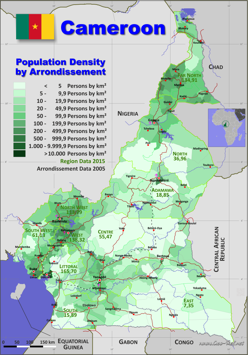
Country map - Administrative structure - Population density of Cameroon
Cameroon - Click on the map to get a enlarged image in PDF format!
Other language versions are easy to generate, the description is in an own layer
Conditions for thematic maps with your own data and logotype
Delivery as printable file by e-mail or plot by post office |
|---|
| Layer | |
| Province: | yes |
| Streets: | yes |
| Infrastructure: | yes |
| Rivers: | yes |
|
| Size | bis A2 |
| Supply in | 7 working days |
| Price |
| 1 bis 3 | 75 € |
| > 3 | On request |
|
 |
All information published herein is free usable quoting the source,
including the maps, if they are not modified |
|---|
Statistical Data - Population density according to the administrative structure
The population data in the table below is a estimation for 2015.
Click on the column header brings the table in order of the column header. The default order is the Department name.
| Department |
ISO
3166-2 |
Region |
Capital |
Area
(km²) |
Population |
Density
(pers/km²) |
|---|
| Total |
|
|
|
472 086 |
17 463 836 |
36,99 |
|---|
| Last update: 11/04/2020 - 00:43:47 |
| Bamboutos |
OU-BA |
Ouest |
Mbouda |
1 173 |
292 410 |
249,28 |
| Bénoué |
NO-BE |
Nord |
Garoua |
13 614 |
851 955 |
62,58 |
| Boumba-et-Ngoko |
ES-BN |
Est |
Yokadouma |
30 389 |
115 354 |
3,80 |
| Boyo |
NW-BO |
Nord-Ouest |
Fundong |
1 592 |
124 887 |
78,45 |
| Bui |
NW-BU |
Nord-Ouest |
Kumbo |
2 297 |
321 969 |
140,17 |
| Diamaré |
EN-DI |
Est |
Maroua |
4 665 |
642 227 |
137,67 |
| Dja-et-Lobo |
SU-DL |
Sud |
Sangmélima |
19 911 |
196 951 |
9,89 |
| Djérem |
AD-DJ |
Adamaoua |
Tibati |
13 283 |
124 948 |
9,41 |
| Donga-Mantung |
NW-DM |
Nord-Ouest |
Nkambé |
4 279 |
269 931 |
63,08 |
| Fako |
SW-FA |
Sud-Ouest |
Limbe |
2 093 |
466 412 |
222,84 |
| Faro |
NO-FA |
Nord |
Poli |
11 785 |
69 477 |
5,90 |
| Faro-et-Déo |
AD-FD |
Adamaoua |
Tignère |
10 435 |
82 717 |
7,93 |
| Haute-Sanaga |
CE-HS |
Centre |
Nanga-Eboko |
11 854 |
100 352 |
8,47 |
| Haut-Nkam |
OU-HN |
Ouest |
Bafang |
958 |
144 786 |
151,13 |
| Haut-Nyong |
ES-HN |
Est |
Abong-Mbang |
36 384 |
196 519 |
5,40 |
| Hauts-Plateaux |
OU-HP |
Ouest |
Baham |
415 |
80 678 |
194,40 |
| Kadey |
ES-KA |
Est |
Batouri |
15 884 |
184 098 |
11,59 |
| Koung-Khi |
OU-KK |
Ouest |
Bandjoun |
353 |
65 021 |
184,20 |
| Koupé-Manengouba |
SW-KM |
Sud-Ouest |
Bangem |
3 404 |
105 579 |
31,02 |
| Lebialem |
SW-LE |
Sud-Ouest |
Menji |
617 |
113 736 |
184,34 |
| Lekié |
CE-LE |
Centre |
Monatélé |
2 989 |
286 050 |
95,70 |
| Logone-et-Chari |
EN-LC |
Extrême-Nord |
Kousséri |
12 133 |
486 997 |
40,14 |
| Lom-et-Djérem |
ES-LD |
Est |
Bertoua |
26 345 |
275 784 |
10,47 |
| Manyu |
SW-MN |
Sud-Ouest |
Mamfe |
9 565 |
181 039 |
18,93 |
| Mayo-Banyo |
AD-MB |
Adamaoua |
Banyo |
8 520 |
187 066 |
21,96 |
| Mayo-Danay |
EN-MD |
Extrême-Nord |
Yagoua |
5 303 |
529 061 |
99,77 |
| Mayo-Kani |
EN-KA |
Extrême-Nord |
Kaélé |
5 033 |
404 646 |
80,40 |
| Mayo-Louti |
NO-ML |
Nord |
Guider |
4 162 |
391 326 |
94,02 |
| Mayo-Rey |
NO-MA |
Nord |
Tcholliré |
36 529 |
375 201 |
10,27 |
| Mayo-Sava |
EN-MS |
Extrême-Nord |
Mora |
2 736 |
348 890 |
127,52 |
| Mayo-Tsanaga |
EN-MT |
Extrême-Nord |
Mokolo |
4 393 |
699 971 |
159,34 |
| Mbam-et-Inoubou |
CE-MI |
Centre |
Bafia |
7 125 |
188 927 |
26,52 |
| Mbam-et-Kim |
CE-MK |
Centre |
Ntui |
25 906 |
105 511 |
4,07 |
| Mbéré |
AD-MR |
Adamaoua |
Meiganga |
14 267 |
171 670 |
12,03 |
| Méfou-et-Afamba |
CE-MM |
Centre |
Mfou |
3 338 |
126 025 |
37,75 |
| Méfou-et-Akono |
CE-MN |
Centre |
Ngoumou |
1 329 |
59 017 |
44,41 |
| Meme |
SW-MM |
Sud-Ouest |
Kumba |
3 105 |
326 734 |
105,23 |
| Menchum |
NW-MC |
Nord-Ouest |
Wum |
4 469 |
161 998 |
36,25 |
| Menoua |
OU-ME |
Ouest |
Dschang |
1 380 |
285 764 |
207,08 |
| Mezam |
NW-ME |
Nord-Ouest |
Bamenda |
1 745 |
524 127 |
300,36 |
| Mfoundi |
CE-MF |
Centre |
Yaoundé |
6 336 |
1 881 876 |
297,01 |
| Mifi |
OU-MF |
Ouest |
Bafoussam |
402 |
301 456 |
749,89 |
| Momo |
NW-MO |
Nord-Ouest |
Mbengwi |
1 792 |
138 693 |
77,40 |
| Moungo |
LT-MU |
Littoral |
Nkongsamba |
3 723 |
379 241 |
101,86 |
| Mvila |
SU-MV |
Sud |
Ebolowa |
8 694 |
179 429 |
20,64 |
| Ndé |
OU-ND |
Ouest |
Bangangté |
1 524 |
94 849 |
62,24 |
| Ndian |
SW-ND |
Sud-Ouest |
Mundemba |
6 626 |
122 579 |
18,50 |
| Ngo-Ketunjia |
NW-NK |
Nord-Ouest |
Ndop |
1 126 |
187 348 |
166,38 |
| Nkam |
LT-NK |
Littoral |
Yabassi |
6 291 |
36 730 |
5,84 |
| Noun |
OU-NO |
Ouest |
Foumban |
7 687 |
455 083 |
59,20 |
| Nyong-et-Kéllé |
CE-NK |
Centre |
Éséka |
6 362 |
129 819 |
20,41 |
| Nyong-et-Mfoumou |
CE-NM |
Centre |
Akonolinga |
6 172 |
104 507 |
16,93 |
| Nyong-et-So´o |
CE-NS |
Centre |
Mbalmayo |
3 581 |
115 960 |
32,38 |
| Océan |
SU-OC |
Sud |
Kribi |
11 280 |
179 093 |
15,88 |
| Sanaga-Maritime |
LT-SM |
Littoral |
Édéa |
9 311 |
162 315 |
17,43 |
| Vallée-du-Ntem |
SU-VN |
Sud |
Ambam |
7 303 |
79 182 |
10,84 |
| Vina |
AD-VI |
Adamaoua |
Ngaoundéré |
17 196 |
317 888 |
18,49 |
| Wouri |
LT-WO |
Littoral |
Douala |
923 |
1 931 977 |
2 093,15 |
The version of the HASC
codification used here is the original HASC
codification for the departments, extended by a
2-digit counter for the arrondissements in
alphabetical order belonging to the corresponding
department.
The deviating values of the cumulated areas result
from the original documents.
The results of the 2017 census have not yet been
published to date (17.11.2022); a direct enquiry
to the Central Bureau of the Census and Population
Studies did not yield any results.
| Arrondissement |
HASC m |
Department |
Capital |
Area
(km²) |
Population |
Density
(pers/km²) |
|---|
| Total |
|
|
|
466 393,9 |
17 463 836 |
37,4 |
|---|
| Last update: 11/04/2020 - 00:43:47 |
| Abo Fiko |
LT-MU-01 |
Moungo |
Abo Fiko |
561,9 |
25 018 |
44,5 |
| Abong-Mbang |
ES-HN-01 |
Haut-Nyong |
Abong-Mbang |
1 696,0 |
29 005 |
17,1 |
| Afanloum |
CE-MM-01 |
Méfou-et-Afamba |
Afanloum |
252,9 |
1 787 |
7,1 |
| Ako |
NW-DM-01 |
Donga-Mantung |
Ako |
1 101,0 |
40 349 |
36,6 |
| Akoeman |
CE-NS-01 |
Nyong-et-So'o |
Akoeman |
663,9 |
5 397 |
8,1 |
| Akom |
SU-OC-01 |
Océan |
Akom |
1 931,0 |
8 802 |
4,6 |
| Akono |
CE-MN-01 |
Méfou-et-Akono |
Akono |
182,7 |
8 511 |
46,6 |
| Akonolinga |
CE-NM-01 |
Nyong-et-Mfoumou |
Akonolinga |
2 848,0 |
47 561 |
16,7 |
| Akwaya |
SW-MN-01 |
Manyu |
Akwaya |
3 682,0 |
85 914 |
23,3 |
| Alou |
SW-LE-01 |
Lebialem |
Alou |
152,8 |
35 855 |
234,7 |
| Ambam |
SU-VN-01 |
Vallée-du-Ntem |
Ambam |
2 452,0 |
41 089 |
16,8 |
| Assamba |
CE-MM-02 |
Méfou-et-Afamba |
Assamba |
230,0 |
4 801 |
20,9 |
| Awaé |
CE-MM-03 |
Méfou-et-Afamba |
Awaé |
532,2 |
15 888 |
29,9 |
| Ayos |
CE-NM-02 |
Nyong-et-Mfoumou |
Ayos |
1 650,0 |
22 899 |
13,9 |
| Babadjou |
OU-BA-01 |
Bamboutos |
Babadjou |
196,8 |
36 929 |
187,6 |
| Babessi |
NW-NK-01 |
Ngo-Ketunjia |
Babessi |
372,6 |
49 208 |
132,1 |
| Bafang |
OU-HN-01 |
Haut-Nkam |
Bafang |
106,9 |
29 821 |
279,0 |
| Bafia |
CE-MI-01 |
Mbam-et-Inoubou |
Bafia |
238,9 |
55 506 |
232,3 |
| Bafoussam I |
OU-MF-01 |
Mifi |
Bafoussam |
140,9 |
98 339 |
697,9 |
| Bafoussam II |
OU-MF-02 |
Mifi |
Bafoussam |
178,5 |
121 282 |
679,5 |
| Bafoussam III |
OU-MF-03 |
Mifi |
Bafoussam |
90,6 |
81 835 |
903,3 |
| Bafut |
NW-ME-01 |
Mezam |
Bafut |
486,1 |
57 930 |
119,2 |
| Baham |
OU-HP-1 |
Hauts-Plateaux |
Baham |
76,0 |
19 680 |
258,9 |
| Bakou |
OU-HN-02 |
Haut-Nkam |
Bakou |
176,8 |
5 255 |
29,7 |
| Bali |
NW-ME-02 |
Mezam |
Bali |
111,3 |
30 375 |
272,9 |
| Balikumbat |
NW-NK-02 |
Ngo-Ketunjia |
Balikumbat |
337,2 |
68 537 |
203,3 |
| Bamenda I |
NW-ME-03 |
Mezam |
Bamenda |
87,5 |
28 359 |
324,1 |
| Bamenda II |
NW-ME-04 |
Mezam |
Bamenda |
172,6 |
184 277 |
1 067,7 |
| Bamenda III |
NW-ME-05 |
Mezam |
Bamenda |
69,6 |
110 253 |
1 584,1 |
| Bamendjou |
OU-HP-2 |
Hauts-Plateaux |
Bamendjou |
129,5 |
34 269 |
264,6 |
| Bamusso |
SW-ND-01 |
Ndian |
Bamusso |
658,3 |
19 230 |
29,2 |
| Bana |
OU-HN-03 |
Haut-Nkam |
Bana |
114,3 |
10 254 |
89,7 |
| Bandja |
OU-HN-04 |
Haut-Nkam |
Bandja |
213,5 |
30 931 |
144,9 |
| Bangangté |
OU-ND-01 |
Ndé |
Bangangté |
828,7 |
63 595 |
76,7 |
| Bangem |
SW-KM-01 |
Koupé-Manengouba |
Bangem |
572,5 |
21 411 |
37,4 |
| Bangou |
OU-HP-3 |
Hauts-Plateaux |
Bangou |
155,8 |
15 787 |
101,3 |
| Bangourain |
OU-NO-01 |
Noun |
Bangourain |
394,6 |
30 877 |
78,2 |
| Banka |
OU-HN-05 |
Haut-Nkam |
Banka |
120,8 |
25 290 |
209,4 |
| Bankim |
AD-MB-01 |
Mayo-Banyo |
Bankim |
2 442,0 |
70 132 |
28,7 |
| Banwa |
OU-HN-06 |
Haut-Nkam |
Banwa |
107,7 |
11 693 |
108,6 |
| Banyo |
AD-MB-02 |
Mayo-Banyo |
Banyo |
5 066,0 |
93 880 |
18,5 |
| Baré-Bakem |
LT-MU-02 |
Moungo |
Baré-Bakem |
237,1 |
16 485 |
69,5 |
| Baschéo |
NO-BE-01 |
Bénoué |
Baschéo |
1 049,0 |
26 743 |
25,5 |
| Bassamba |
OU-ND-02 |
Ndé |
Bassamba |
11,4 |
2 814 |
246,8 |
| Batcham |
OU-BA-02 |
Bamboutos |
Batcham |
210,5 |
83 817 |
398,2 |
| Batchenga |
CE-LE-01 |
Lekié |
Batchenga |
234,0 |
9 303 |
39,8 |
| Batibo |
NW-MO-01 |
Momo |
Batibo |
347,8 |
44 619 |
128,3 |
| Batié |
OU-HP-4 |
Hauts-Plateaux |
Batié |
72,3 |
10 942 |
151,3 |
| Batouri |
ES-KA-01 |
Kadey |
Batouri |
3 710,0 |
67 007 |
18,1 |
| Bayangam |
OU-KK-01 |
Koung-Khi |
Bayangam |
78,0 |
13 397 |
171,8 |
| Bazou |
OU-ND-03 |
Ndé |
Bazou |
221,4 |
14 912 |
67,4 |
| Bebend |
ES-HN-02 |
Haut-Nyong |
Bebend |
889,2 |
9 335 |
10,5 |
| Beka |
SW-FA-08 |
Faro |
Beka |
1 656,0 |
31 595 |
19,1 |
| Bélabo |
ES-LD-01 |
Lom-et-Djérem |
Bélabo |
6 641,0 |
30 953 |
4,7 |
| Belel |
AD-VI-01 |
Vina |
Belel |
2 030,0 |
37 663 |
18,6 |
| Belo |
NW-BO-01 |
Boyo |
Belo |
251,1 |
40 757 |
162,3 |
| Bengbis |
SU-DL-01 |
Dja-et-Lobo |
Bengbis |
2 254,0 |
13 075 |
5,8 |
| Bertoua I |
ES-LD-02 |
Lom-et-Djérem |
Bertoua |
167,6 |
52 355 |
312,4 |
| Bertoua II |
ES-LD-03 |
Lom-et-Djérem |
Bertoua |
91,1 |
42 534 |
466,9 |
| Bétaré-Oya |
ES-LD-04 |
Lom-et-Djérem |
Bétaré-Oya |
11 750,0 |
41 173 |
3,5 |
| Bibemi |
NO-BE-02 |
Bénoué |
Bibemi |
2 566,0 |
133 191 |
51,9 |
| Bibey |
CE-HS-01 |
Haute-Sanaga |
Bibey |
1 237,0 |
4 875 |
3,9 |
| Bikok |
CE-MN-02 |
Méfou-et-Akono |
Bikok |
458,5 |
16 278 |
35,5 |
| Bipindi |
SU-OC-02 |
Océan |
Bipindi |
1 320,0 |
14 118 |
10,7 |
| Biwong-Bane |
SU-MV-01 |
Mvila |
Biwong-Bane |
458,4 |
13 151 |
28,7 |
| Biwong-Bulu |
SU-MV-02 |
Mvila |
Biwong-Bulu |
977,6 |
12 867 |
13,2 |
| Biyouha |
CE-NK-01 |
Nyong-et-Kéllé |
Biyouha |
203,7 |
3 386 |
16,6 |
| Blangoua |
EN-LC-01 |
Logone-et-Chari |
Blangoua |
220,9 |
50 398 |
228,1 |
| Bogo |
EN-DI-01 |
Diamaré |
Bogo |
1 017,0 |
95 230 |
93,6 |
| Bokito |
CE-MI-02 |
Mbam-et-Inoubou |
Bokito |
1 509,0 |
40 228 |
26,7 |
| Bombé |
ES-KA-02 |
Kadey |
Bombé |
1 014,0 |
16 147 |
15,9 |
| Bondjock |
CE-NK-02 |
Nyong-et-Kéllé |
Bondjock |
284,0 |
8 431 |
29,7 |
| Bot-Makak |
CE-NK-03 |
Nyong-et-Kéllé |
Bot-Makak |
467,9 |
17 089 |
36,5 |
| Bourrha |
EN-MT-01 |
Mayo-Tsanaga |
Bourrha |
689,8 |
88 585 |
128,4 |
| Buea |
SW-FA-01 |
Fako |
Buea |
534,2 |
131 325 |
245,8 |
| Bum |
NW-BO-02 |
Boyo |
Bum |
707,0 |
17 838 |
25,2 |
| Campo |
SU-OC-03 |
Océan |
Campo |
2 756,0 |
6 923 |
2,5 |
| Darak |
EN-LC-02 |
Logone-et-Chari |
Darak |
1 877,0 |
23 901 |
12,7 |
| Dargala |
EN-DI-02 |
Diamaré |
Dargala |
388,8 |
33 142 |
85,2 |
| Datcheka |
EN-MD-01 |
Mayo-Danay |
Datcheka |
119,9 |
31 545 |
263,1 |
| Dembo |
NO-BE-03 |
Bénoué |
Dembo |
602,6 |
15 816 |
26,2 |
| Demsa |
NO-BE-04 |
Bénoué |
Demsa |
565,3 |
37 282 |
66,0 |
| Deuk |
CE-MI-03 |
Mbam-et-Inoubou |
Deuk |
1 447,0 |
11 485 |
7,9 |
| Diang |
ES-LD-05 |
Lom-et-Djérem |
Diang |
826,4 |
15 795 |
19,1 |
| Dibamba |
LT-SM-01 |
Sanaga-Maritime |
Dibamba |
845,7 |
5 350 |
6,3 |
| Dibang |
CE-NK-04 |
Nyong-et-Kéllé |
Dibang |
467,1 |
9 063 |
19,4 |
| Dibombari |
LT-MU-03 |
Moungo |
Dibombari |
428,1 |
17 141 |
40,0 |
| Dikome-Balue |
SW-ND-02 |
Ndian |
Dikome-Balue |
404,7 |
13 364 |
33,0 |
| Dimako |
ES-HN-03 |
Haut-Nyong |
Dimako |
721,4 |
12 894 |
17,9 |
| Dir |
AD-MR-01 |
Mbéré |
Dir |
4 912,0 |
34 284 |
7,0 |
| Dizangué |
LT-SM-02 |
Sanaga-Maritime |
Dizangué |
952,7 |
17 086 |
17,9 |
| Dja |
ES-HN-04 |
Haut-Nyong |
Dja |
5 339,0 |
10 431 |
2,0 |
| Djebem |
OU-KK-02 |
Koung-Khi |
Djebem |
122,3 |
10 987 |
89,8 |
| Djohong |
AD-MR-02 |
Mbéré |
Djohong |
2 471,0 |
24 445 |
9,9 |
| Djoum |
SU-DL-02 |
Dja-et-Lobo |
Djoum |
5 442,0 |
18 050 |
3,3 |
| Douala I |
LT-WO-01 |
Wouri |
Douala |
32,1 |
223 214 |
6 953,7 |
| Douala II |
LT-WO-02 |
Wouri |
Douala |
16,1 |
261 407 |
16 236,5 |
| Douala III |
LT-WO-03 |
Wouri |
Douala |
167,4 |
646 347 |
3 861,1 |
| Douala IV |
LT-WO-04 |
Wouri |
Douala |
204,0 |
250 626 |
1 228,6 |
| Douala V |
LT-WO-05 |
Wouri |
Douala |
160,8 |
544 919 |
3 388,8 |
| Douala VI |
LT-WO-06 |
Wouri |
Douala |
390,5 |
5 464 |
14,0 |
| Doumaintang |
ES-HN-05 |
Haut-Nyong |
Doumaintang |
1 911,0 |
7 956 |
4,2 |
| Doumé |
ES-HN-06 |
Haut-Nyong |
Doumé |
1 203,0 |
18 429 |
15,3 |
| Dschang |
OU-ME-01 |
Menoua |
Dschang |
221,1 |
101 385 |
458,5 |
| Dzeng |
CE-NS-02 |
Nyong-et-So'o |
Dzeng |
763,2 |
9 412 |
12,3 |
| Ebebda |
CE-LE-02 |
Lekié |
Ebebda |
217,9 |
21 368 |
98,1 |
| Ebolowa I |
SU-MV-03 |
Mvila |
Ebolowa |
734,7 |
40 538 |
55,2 |
| Ebolowa II |
SU-MV-04 |
Mvila |
Ebolowa |
1 995,0 |
55 957 |
28,0 |
| Édéa I |
LT-SM-03 |
Sanaga-Maritime |
Édéa |
1 009,0 |
64 761 |
64,2 |
| Édéa II |
LT-SM-04 |
Sanaga-Maritime |
Édéa |
780,8 |
13 539 |
17,3 |
| Edzendouan |
CE-MM-04 |
Méfou-et-Afamba |
Edzendouan |
403,5 |
4 436 |
11,0 |
| Efoulan |
SU-MV-05 |
Mvila |
Efoulan |
856,4 |
8 905 |
10,4 |
| Ekondo-Titi |
SW-ND-03 |
Ndian |
Ekondo-Titi |
696,0 |
56 503 |
81,2 |
| Elig-Mfomo |
CE-LE-03 |
Lekié |
Elig-Mfomo |
203,2 |
16 161 |
79,5 |
| Endom |
CE-NM-03 |
Nyong-et-Mfoumou |
Endom |
836,2 |
14 789 |
17,7 |
| Éséka |
CE-NK-05 |
Nyong-et-Kéllé |
Éséka |
840,0 |
23 242 |
27,7 |
| Esse |
CE-MM-05 |
Méfou-et-Afamba |
Esse |
838,9 |
16 822 |
20,1 |
| Evodoula |
CE-LE-04 |
Lekié |
Evodoula |
184,1 |
18 899 |
102,7 |
| Eyumodjock |
SW-MN-02 |
Manyu |
Eyumodjock |
1 373,0 |
35 999 |
26,2 |
| Figuil |
NO-ML-01 |
Mayo-Louti |
Figuil |
866,8 |
67 997 |
78,4 |
| Fokoué |
OU-ME-02 |
Menoua |
Fokoué |
169,1 |
9 576 |
56,6 |
| Fongo-Tongo |
OU-ME-03 |
Menoua |
Fongo-Tongo |
151,4 |
18 822 |
124,3 |
| Fontem |
SW-LE-02 |
Lebialem |
Fontem |
236,7 |
39 706 |
167,7 |
| Fotokol |
EN-LC-03 |
Logone-et-Chari |
Fotokol |
363,0 |
36 893 |
101,6 |
| Foumban |
OU-NO-02 |
Noun |
Foumban |
560,2 |
106 309 |
189,8 |
| Foumbot |
OU-NO-03 |
Noun |
Foumbot |
759,6 |
76 486 |
100,7 |
| Fundong |
NW-BO-03 |
Boyo |
Fundong |
412,2 |
45 831 |
111,2 |
| Fungom |
NW-MC-01 |
Menchum |
Fungom |
2 098,0 |
58 666 |
28,0 |
| Furu-Awa |
NW-MC-02 |
Menchum |
Furu-Awa |
1 186,0 |
13 997 |
11,8 |
| Galim |
OU-BA-03 |
Bamboutos |
Galim |
504,5 |
51 014 |
101,1 |
| Galim-Tignère |
AD-FD-01 |
Faro-et-Déo |
Galim-Tignère |
1 807,0 |
25 739 |
14,2 |
| Gari-Gombo |
ES-BN-01 |
Boumba-et-Ngoko |
Gari-Gombo |
3 453,0 |
15 978 |
4,6 |
| Garoua I |
NO-BE-05 |
Bénoué |
Garoua |
89,6 |
120 232 |
1 341,9 |
| Garoua II |
NO-BE-06 |
Bénoué |
Garoua |
74,4 |
117 841 |
1 583,9 |
| Garoua III |
NO-BE-07 |
Bénoué |
Garoua |
260,6 |
27 229 |
104,5 |
| Garoua-Boulaï |
ES-LD-06 |
Lom-et-Djérem |
Garoua-Boulaï |
2 221,0 |
41 388 |
18,6 |
| Gazawa |
EN-DI-03 |
Diamaré |
Gazawa |
188,7 |
27 395 |
145,2 |
| Gobo |
EN-MD-02 |
Mayo-Danay |
Gobo |
599,8 |
53 119 |
88,6 |
| Goulfey |
EN-LC-04 |
Logone-et-Chari |
Goulfey |
1 639,0 |
58 117 |
35,5 |
| Guéré |
EN-MD-03 |
Mayo-Danay |
Guéré |
266,2 |
38 328 |
144,0 |
| Guider |
NO-ML-02 |
Mayo-Louti |
Guider |
1 946,0 |
223 503 |
114,9 |
| Guidiguis |
EN-KA-01 |
Mayo-Kani |
Guidiguis |
385,4 |
43 632 |
113,2 |
| Hile-Alifa |
EN-LC-05 |
Logone-et-Chari |
Hile-Alifa |
272,2 |
18 425 |
67,7 |
| Hina |
EN-MT-02 |
Mayo-Tsanaga |
Hina |
474,4 |
43 755 |
92,2 |
| Idabato |
SW-ND-04 |
Ndian |
Idabato |
120,8 |
3 482 |
28,8 |
| Isanguele |
SW-ND-05 |
Ndian |
Isanguele |
332,1 |
3 476 |
10,5 |
| Jakiri |
NW-BU-01 |
Bui |
Jakiri |
404,3 |
47 022 |
116,3 |
| Kaélé |
EN-KA-02 |
Mayo-Kani |
Kaélé |
1 316,0 |
105 504 |
80,2 |
| Kai-Kai |
EN-MD-04 |
Mayo-Danay |
Kaï-Kaï |
810,1 |
55 366 |
68,3 |
| Kalfou |
EN-MD-05 |
Mayo-Danay |
Kalfou |
720,8 |
26 203 |
36,4 |
| Kar-Hay |
EN-MD-06 |
Mayo-Danay |
Kar-Hay |
286,7 |
42 963 |
149,9 |
| Kékem |
OU-HN-07 |
Haut-Nkam |
Kékem |
129,1 |
31 542 |
244,3 |
| Kette |
ES-KA-03 |
Kadey |
Kette |
1 943,0 |
31 129 |
16,0 |
| Kiiki |
CE-MI-04 |
Mbam-et-Inoubou |
Kiiki |
227,8 |
8 519 |
37,4 |
| Kolofata |
EN-MS-01 |
Mayo-Sava |
Kolofata |
631,0 |
77 857 |
123,4 |
| Kombo-Abedimo |
SW-ND-06 |
Ndian |
Kombo-Abedimo |
251,0 |
2 146 |
8,5 |
| Kombo-Itindi |
SW-ND-07 |
Ndian |
Kombo-Itindi |
375,9 |
2 958 |
7,9 |
| Kontcha |
AD-FD-02 |
Faro-et-Déo |
Kontcha |
393,4 |
6 938 |
17,6 |
| Kon-Yambetta |
CE-MI-05 |
Mbam-et-Inoubou |
Kon-Yambetta |
349,5 |
8 692 |
24,9 |
| Konye |
SW-MM-01 |
Meme |
Konye |
977,9 |
44 711 |
45,7 |
| Kouoptamo |
OU-NO-04 |
Noun |
Kouoptamo |
312,4 |
48 772 |
156,1 |
| Kousséri |
EN-LC-06 |
Logone-et-Chari |
Kousséri |
143,0 |
101 246 |
708,0 |
| Koutaba |
OU-NO-05 |
Noun |
Koutaba |
451,1 |
49 171 |
109,0 |
| Koza |
EN-MT-03 |
Mayo-Tsanaga |
Koza |
356,2 |
81 076 |
227,6 |
| Kribi I |
SU-OC-04 |
Océan |
Kribi |
203,2 |
29 886 |
147,1 |
| Kribi II |
SU-OC-05 |
Océan |
Kribi |
104,9 |
40 679 |
387,8 |
| Kumba I |
SW-MM-02 |
Meme |
Kumba |
431,0 |
68 095 |
158,0 |
| Kumba II |
SW-MM-03 |
Meme |
Kumba |
231,6 |
62 878 |
271,5 |
| Kumba III |
SW-MM-04 |
Meme |
Kumba |
408,3 |
35 358 |
86,6 |
| Kumbo |
NW-BU-02 |
Bui |
Kumbo |
227,1 |
83 479 |
367,6 |
| Kyé-Ossi |
SU-VN-02 |
Vallée-du-Ntem |
Kyé-Ossi |
268,4 |
17 117 |
63,8 |
| Lagdo |
NO-BE-08 |
Bénoué |
Lagdo |
2 232,0 |
142 129 |
63,7 |
| Lembe-Yezoum |
CE-HS-02 |
Haute-Sanaga |
Lembe-Yezoum |
1 018,0 |
7 207 |
7,1 |
| Limbé I |
SW-FA-02 |
Fako |
Limbé |
79,9 |
93 255 |
1 167,1 |
| Limbé II |
SW-FA-03 |
Fako |
Limbé |
58,4 |
16 401 |
280,8 |
| Limbé III |
SW-FA-04 |
Fako |
Limbé |
112,5 |
8 554 |
76,0 |
| Lobo |
CE-LE-05 |
Lekié |
Lobo |
302,4 |
10 157 |
33,6 |
| Logone-Birni |
EN-LC-07 |
Logone-et-Chari |
Logone-Birni |
2 808,0 |
52 589 |
18,7 |
| Lokoundje |
SU-OC-06 |
Océan |
Lokoundje |
2 290,0 |
22 681 |
9,9 |
| Lolodorf |
SU-OC-07 |
Océan |
Lolodorf |
964,0 |
14 326 |
14,9 |
| Lomié |
ES-HN-07 |
Haut-Nyong |
Lomié |
7 312,0 |
18 952 |
2,6 |
| Loum |
LT-MU-04 |
Moungo |
Loum |
283,3 |
39 707 |
140,2 |
| Ma'an |
SU-VN-03 |
Vallée-du-Ntem |
Ma'an |
3 987,0 |
12 448 |
3,1 |
| Madingring |
NO-MA-01 |
Mayo-Rey |
Madingring |
3 080,0 |
57 347 |
18,6 |
| Maga |
EN-MD-07 |
Mayo-Danay |
Maga |
1 058,0 |
85 100 |
80,4 |
| Magba |
OU-NO-06 |
Noun |
Magba |
1 174,0 |
35 628 |
30,3 |
| Makak |
CE-NK-06 |
Nyong-et-Kéllé |
Makak |
1 003,0 |
29 135 |
29,0 |
| Makary |
EN-LC-08 |
Logone-et-Chari |
Makary |
1 176,0 |
104 843 |
89,2 |
| Makénéné |
CE-MI-06 |
Mbam-et-Inoubou |
Makénéné |
703,3 |
16 564 |
23,6 |
| Malentouen |
OU-NO-07 |
Noun |
Malentouen |
1 084,0 |
45 121 |
41,6 |
| Mamfé Central |
SW-MN-03 |
Manyu |
Mamfé Central |
3 199,0 |
31 641 |
9,9 |
| Mandjou |
ES-LD-07 |
Lom-et-Djérem |
Mandjou |
2 643,0 |
17 097 |
6,5 |
| Manjo |
LT-MU-05 |
Moungo |
Manjo |
333,2 |
34 230 |
102,7 |
| Maroua I |
EN-DI-04 |
Diamaré |
Maroua |
367,6 |
134 934 |
367,1 |
| Maroua II |
EN-DI-05 |
Diamaré |
Maroua |
42,8 |
108 902 |
2 544,4 |
| Maroua III |
EN-DI-06 |
Diamaré |
Maroua |
726,4 |
86 574 |
119,2 |
| Martap |
AD-VI-02 |
Vina |
Martap |
4 628,0 |
24 815 |
5,4 |
| Massangam |
OU-NO-08 |
Noun |
Massangam |
2 209,0 |
38 736 |
17,5 |
| Massock-Songloulou |
LT-SM-05 |
Sanaga-Maritime |
Massock-Songloulou |
576,3 |
5 044 |
8,8 |
| Matomb |
CE-NK-07 |
Nyong-et-Kéllé |
Matomb |
593,3 |
11 512 |
19,4 |
| Mayo-Baléo |
AD-FD-03 |
Faro-et-Déo |
Mayo-Baléo |
3 580,0 |
15 873 |
4,4 |
| Mayo-Darlé |
AD-MB-03 |
Mayo-Banyo |
Mayo-Darlé |
966,0 |
23 054 |
23,9 |
| Mayo-Hourna |
NO-BE-09 |
Bénoué |
Mayo-Hourna |
957,0 |
21 445 |
22,4 |
| Mayo-Moskota |
EN-MT-04 |
Mayo-Tsanaga |
Mayo-Moskota |
271,8 |
73 716 |
271,2 |
| Mayo-Oulo |
NO-ML-03 |
Mayo-Louti |
Mayo-Oulo |
1 395,0 |
99 826 |
71,6 |
| Mbalmayo |
CE-NS-03 |
Nyong-et-So'o |
Mbalmayo |
494,3 |
62 808 |
127,1 |
| Mbandjock |
CE-HS-03 |
Haute-Sanaga |
Mbandjock |
936,2 |
21 076 |
22,5 |
| Mbang |
ES-KA-04 |
Kadey |
Mbang |
5 325,0 |
25 603 |
4,8 |
| Mbanga |
LT-MU-06 |
Moungo |
Mbanga |
451,7 |
35 415 |
78,4 |
| Mbangassina |
CE-MK-01 |
Mbam-et-Kim |
Mbangassina |
484,6 |
41 180 |
85,0 |
| Mbankomo |
CE-MN-03 |
Méfou-et-Akono |
Mbankomo |
445,1 |
20 305 |
45,6 |
| Mbe |
AD-VI-03 |
Vina |
Mbe |
1 717,0 |
17 478 |
10,2 |
| Mbengwi |
NW-MO-02 |
Momo |
Mbengwi |
468,4 |
31 591 |
67,4 |
| Mboanz |
ES-HN-08 |
Haut-Nyong |
Mboanz |
404,8 |
13 608 |
33,6 |
| Mboma |
ES-HN-09 |
Haut-Nyong |
Mboma |
194,8 |
8 120 |
41,7 |
| Mbonge |
SW-MM-05 |
Meme |
Mbonge |
802,9 |
115 692 |
144,1 |
| Mbotoro |
ES-KA-05 |
Kadey |
Mbotoro |
659,1 |
7 674 |
11,6 |
| Mbouda |
OU-BA-04 |
Bamboutos |
Mbouda |
260,8 |
120 650 |
462,6 |
| Mbven |
NW-BU-03 |
Bui |
Mbven |
693,7 |
20 289 |
29,2 |
| Meiganga |
AD-MR-03 |
Mbéré |
Meiganga |
6 761,0 |
88 745 |
13,1 |
| Melong |
LT-MU-07 |
Moungo |
Melong |
589,8 |
54 279 |
92,0 |
| Menchum Valley |
NW-MC-03 |
Menchum |
Menchum |
956,5 |
50 235 |
52,5 |
| Mengang |
CE-NM-04 |
Nyong-et-Mfoumou |
Mengang |
511,3 |
8 031 |
15,7 |
| Mengong |
SU-MV-06 |
Mvila |
Mengong |
886,4 |
17 222 |
19,4 |
| Mengueme |
CE-NS-04 |
Nyong-et-So'o |
Mengueme |
532,1 |
7 527 |
14,1 |
| Meri |
EN-DI-07 |
Diamaré |
Meri |
647,8 |
86 834 |
134,0 |
| Messamena |
ES-HN-10 |
Haut-Nyong |
Messamena |
3 103,0 |
26 153 |
8,4 |
| Messok |
ES-HN-11 |
Haut-Nyong |
Messok |
2 636,0 |
11 213 |
4,3 |
| Messondo |
CE-NK-08 |
Nyong-et-Kéllé |
Messondo |
1 944,0 |
14 139 |
7,3 |
| Meyomessala |
SU-DL-03 |
Dja-et-Lobo |
Meyomessala |
2 119,0 |
31 366 |
14,8 |
| Meyomessi |
SU-DL-04 |
Dja-et-Lobo |
Meyomessi |
1 241,0 |
9 227 |
7,4 |
| Mfou |
CE-MM-06 |
Méfou-et-Afamba |
Mfou |
499,9 |
37 209 |
74,4 |
| Mindif |
EN-KA-03 |
Mayo-Kani |
Mindif |
995,2 |
50 530 |
50,8 |
| Minta |
CE-HS-04 |
Haute-Sanaga |
Minta |
2 063,0 |
11 406 |
5,5 |
| Mintom |
SU-DL-05 |
Dja-et-Lobo |
Mintom |
4 064,0 |
6 130 |
1,5 |
| Misaje |
NW-DM-02 |
Donga-Mantung |
Misaje |
814,9 |
22 641 |
27,8 |
| Mogode |
EN-MT-05 |
Mayo-Tsanaga |
Mogode |
562,3 |
112 905 |
200,8 |
| Mokolo |
EN-MT-06 |
Mayo-Tsanaga |
Mokolo |
1 784,0 |
242 274 |
135,8 |
| Moloundou |
ES-BN-02 |
Boumba-et-Ngoko |
Moloundou |
9 948,0 |
18 174 |
1,8 |
| Mombo |
LT-MU-08 |
Moungo |
Mombo |
117,3 |
5 530 |
47,1 |
| Monatélé |
CE-LE-06 |
Lekié |
Monatélé |
415,9 |
36 933 |
88,8 |
| Mora |
EN-MS-02 |
Mayo-Sava |
Mora |
1 690,0 |
179 777 |
106,4 |
| Mouanko |
LT-SM-06 |
Sanaga-Maritime |
Mouanko |
1 282,0 |
9 162 |
7,1 |
| Moulvoudaye |
EN-KA-04 |
Mayo-Kani |
Moulvoudaye |
1 140,0 |
82 368 |
72,3 |
| Moutourwa |
EN-KA-05 |
Mayo-Kani |
Moutourwa |
545,2 |
40 197 |
73,7 |
| Mundemba |
SW-ND-08 |
Ndian |
Mundemba |
1 857,0 |
14 385 |
7,7 |
| Muyuka |
SW-FA-05 |
Fako |
Muyuka |
476,6 |
86 268 |
181,0 |
| Mvangan |
SU-MV-07 |
Mvila |
Mvangan |
2 079,0 |
16 114 |
7,8 |
| Mvengue |
SU-OC-08 |
Océan |
Mvengue |
819,1 |
17 757 |
21,7 |
| Nanga-Eboko |
CE-HS-05 |
Haute-Sanaga |
Nanga-Eboko |
5 397,0 |
29 814 |
5,5 |
| Ndelele |
ES-KA-06 |
Kadey |
Ndelele |
1 984,0 |
26 127 |
13,2 |
| Ndem-Nam |
ES-KA-07 |
Kadey |
Ndem-Nam |
1 489,0 |
10 411 |
7,0 |
| Ndikiniméki |
CE-MI-07 |
Mbam-et-Inoubou |
Ndikiniméki |
1 825,0 |
17 462 |
9,6 |
| Ndom |
LT-SM-07 |
Sanaga-Maritime |
Ndom |
670,1 |
10 340 |
15,4 |
| Ndop |
NW-NK-03 |
Ngo-Ketunjia |
Ndop |
352,6 |
69 603 |
197,4 |
| Ndoukoula |
EN-DI-08 |
Diamaré |
Ndoukoula |
502,4 |
32 091 |
63,9 |
| Ndu |
NW-DM-03 |
Donga-Mantung |
Ndu |
480,3 |
73 955 |
154,0 |
| Ngambe |
LT-SM-08 |
Sanaga-Maritime |
Ngambe |
937,3 |
6 210 |
6,6 |
| Ngambè-Tikar |
CE-MK-02 |
Mbam-et-Kim |
Ngambè-Tikar |
6 902,0 |
12 489 |
1,8 |
| Nganha |
AD-VI-04 |
Vina |
Nganha |
2 078,0 |
28 443 |
13,7 |
| Ngaoui |
AD-MR-04 |
Mbéré |
Ngaoui |
266,6 |
24 196 |
90,8 |
| Ngaoundal |
AD-DJ-01 |
Djérem |
Ngaoundal |
3 711,0 |
52 867 |
14,2 |
| Ngaoundéré I |
AD-VI-05 |
Vina |
Ngaoundéré |
323,8 |
78 277 |
241,7 |
| Ngaoundéré II |
AD-VI-06 |
Vina |
Ngaoundéré |
257,1 |
84 959 |
330,5 |
| Ngaoundéré III |
AD-VI-07 |
Vina |
Ngaoundéré |
237,6 |
17 527 |
73,8 |
| Ngie |
NW-MO-03 |
Momo |
Ngie |
221,5 |
17 697 |
79,9 |
| Ngog-Mapubi |
CE-NK-09 |
Nyong-et-Kéllé |
Ngog-Mapubi |
271,3 |
9 137 |
33,7 |
| Ngomedzap |
CE-NS-05 |
Nyong-et-So'o |
Ngomedzap |
660,3 |
17 169 |
26,0 |
| Ngoro |
CE-MK-03 |
Mbam-et-Kim |
Ngoro |
1 991,0 |
13 892 |
7,0 |
| Ngoulemakong |
SU-MV-08 |
Mvila |
Ngoulemakong |
690,4 |
14 675 |
21,3 |
| Ngoumou |
CE-MN-04 |
Méfou-et-Akono |
Ngoumou |
250,0 |
13 923 |
55,7 |
| Ngoura |
ES-LD-08 |
Lom-et-Djérem |
Ngoura |
1 719,0 |
34 489 |
20,1 |
| Ngoyla |
ES-HN-12 |
Haut-Nyong |
Ngoyla |
7 820,0 |
4 424 |
0,6 |
| Nguelemendouka |
ES-HN-13 |
Haut-Nyong |
Nguelemendouka |
1 058,0 |
21 097 |
19,9 |
| Nguibassal |
CE-NK-10 |
Nyong-et-Kéllé |
Nguibassal |
279,1 |
4 685 |
16,8 |
| Nguti |
SW-KM-02 |
Koupé-Manengouba |
Nguti |
1 851,0 |
27 151 |
14,7 |
| Ngwei |
LT-SM-09 |
Sanaga-Maritime |
Ngwei |
876,2 |
4 831 |
5,5 |
| Niete |
SU-OC-09 |
Océan |
Niete |
1 001,0 |
23 921 |
23,9 |
| Nitoukou |
CE-MI-08 |
Mbam-et-Inoubou |
Nitoukou |
170,9 |
4 831 |
28,3 |
| Njikwa |
NW-MO-04 |
Momo |
Njikwa |
313,9 |
16 634 |
53,0 |
| Njimom |
OU-NO-09 |
Noun |
Njimom |
700,6 |
23 983 |
34,2 |
| Njinikom |
NW-BO-04 |
Boyo |
Njinikom |
280,8 |
20 461 |
72,9 |
| Njombe-Penja |
LT-MU-09 |
Moungo |
Njombe-Penja |
261,9 |
31 792 |
121,4 |
| Nkambé |
NW-DM-04 |
Donga-Mantung |
Nkambé |
469,9 |
63 032 |
134,1 |
| Nkolafamba |
CE-MM-07 |
Méfou-et-Afamba |
Nkolafamba |
329,5 |
14 494 |
44,0 |
| Nkolmetet |
CE-NS-06 |
Nyong-et-So'o |
Nkolmetet |
475,6 |
13 647 |
28,7 |
| Nkondjock |
LT-NK-01 |
Nkam |
Nkondjock |
966,8 |
17 428 |
18,0 |
| Nkong-Ni |
OU-ME-04 |
Menoua |
Nkong-Ni |
210,9 |
53 367 |
253,0 |
| Nkongsamba I |
LT-MU-10 |
Moungo |
Nkongsamba |
150,5 |
52 434 |
348,4 |
| Nkongsamba II |
LT-MU-11 |
Moungo |
Nkongsamba |
25,4 |
37 154 |
1 462,8 |
| Nkongsamba III |
LT-MU-12 |
Moungo |
Nkongsamba |
48,6 |
15 795 |
325,0 |
| Nkoteng |
CE-HS-06 |
Haute-Sanaga |
Nkoteng |
762,5 |
19 797 |
26,0 |
| Nkum |
NW-BU-04 |
Bui |
Nkum |
260,3 |
44 059 |
169,3 |
| Nlonako |
LT-MU-13 |
Moungo |
Nlonako |
394,0 |
14 261 |
36,2 |
| Noni |
NW-BU-05 |
Bui |
Noni |
310,6 |
39 400 |
126,9 |
| Nord-Makombé |
LT-NK-02 |
Nkam |
Makombé |
505,5 |
3 999 |
7,9 |
| Nsem |
CE-HS-07 |
Haute-Sanaga |
Nsem |
320,4 |
6 177 |
19,3 |
| Ntui |
CE-MK-04 |
Mbam-et-Kim |
Ntui |
993,4 |
25 618 |
25,8 |
| Nwa |
NW-DM-05 |
Donga-Mantung |
Nwa |
1 444,0 |
69 954 |
48,4 |
| Nyakokombo |
CE-NM-05 |
Nyong-et-Mfoumou |
Nyakokombo |
286,0 |
11 227 |
39,3 |
| Nyambaka |
AD-VI-08 |
Vina |
Nyambaka |
5 875,0 |
28 726 |
4,9 |
| Nyanon |
LT-SM-10 |
Sanaga-Maritime |
Nyanon |
520,8 |
12 517 |
24,0 |
| Obala |
CE-LE-07 |
Lekié |
Obala |
400,6 |
78 929 |
197,0 |
| Okola |
CE-LE-08 |
Lekié |
Okola |
578,0 |
41 081 |
71,1 |
| Oku |
NW-BU-06 |
Bui |
Oku |
315,3 |
87 720 |
278,2 |
| Olamze |
SU-VN-04 |
Vallée-du-Ntem |
Olamze |
477,1 |
8 528 |
17,9 |
| Ombessa |
CE-MI-09 |
Mbam-et-Inoubou |
Ombessa |
359,3 |
25 640 |
71,4 |
| Oveng |
SU-DL-06 |
Dja-et-Lobo |
Oveng |
1 782,0 |
6 007 |
3,4 |
| Penka-Michel |
OU-ME-05 |
Menoua |
Penka-Michel |
270,0 |
65 135 |
241,2 |
| Petté |
EN-DI-09 |
Diamaré |
Petté |
880,1 |
37 125 |
42,2 |
| Pitoa |
NO-BE-10 |
Bénoué |
Pitoa |
1 539,0 |
76 715 |
49,8 |
| Poli |
SW-FA-09 |
Faro |
Poli |
10 050,0 |
37 882 |
3,8 |
| Porhi |
EN-KA-06 |
Mayo-Kani |
Porhi |
288,6 |
38 809 |
134,5 |
| Pouma |
LT-SM-11 |
Sanaga-Maritime |
Pouma |
704,2 |
13 475 |
19,1 |
| Poumougne |
OU-KK-03 |
Koung-Khi |
Poumougne |
143,7 |
40 637 |
282,8 |
| Rey-Bouba |
NO-MA-02 |
Mayo-Rey |
Rey-Bouba |
8 822,0 |
116 192 |
13,2 |
| Sa'a |
CE-LE-09 |
Lekié |
Sa'a |
500,7 |
53 219 |
106,3 |
| Salapoumbé |
ES-BN-03 |
Boumba-et-Ngoko |
Salapoumbé |
5 504,0 |
17 240 |
3,1 |
| Sangmélima |
SU-DL-07 |
Dja-et-Lobo |
Sangmélima |
1 936,0 |
82 513 |
42,6 |
| Santa |
NW-ME-06 |
Mezam |
Santa |
532,9 |
64 391 |
120,8 |
| Santchou |
OU-ME-06 |
Menoua |
Santchou |
362,5 |
37 479 |
103,4 |
| Soa |
CE-MM-08 |
Méfou-et-Afamba |
Soa |
272,2 |
30 588 |
112,4 |
| Somalomo |
ES-HN-14 |
Haut-Nyong |
Somalomo |
1 763,0 |
4 902 |
2,8 |
| Soulédé-Roua |
EN-MT-07 |
Mayo-Tsanaga |
Soulédé-Roua |
240,1 |
57 660 |
240,1 |
| Taibong |
EN-KA-07 |
Mayo-Kani |
Taibong |
327,1 |
43 606 |
133,3 |
| Tchati-Bali |
EN-MD-08 |
Mayo-Danay |
Tchati-Bali |
96,7 |
32 063 |
331,6 |
| Tcheboa |
NO-BE-11 |
Bénoué |
Tcheboa |
2 634,0 |
92 658 |
35,2 |
| Tcholliré |
NO-MA-03 |
Mayo-Rey |
Tcholliré |
14 610,0 |
47 296 |
3,2 |
| Tibati |
AD-DJ-02 |
Djérem |
Tibati |
9 601,0 |
72 081 |
7,5 |
| Tignère |
AD-FD-04 |
Faro-et-Déo |
Tignère |
4 872,0 |
34 167 |
7,0 |
| Tiko |
SW-FA-06 |
Fako |
Tiko |
468,7 |
117 884 |
251,5 |
| Toko |
SW-ND-09 |
Ndian |
Toko |
1 492,0 |
7 035 |
4,7 |
| Tokombéré |
EN-MS-03 |
Mayo-Sava |
Tokombéré |
309,6 |
91 256 |
294,8 |
| Tombel |
SW-KM-03 |
Koupé-Manengouba |
Tombel |
1 027,0 |
57 017 |
55,5 |
| Tonga |
OU-ND-04 |
Ndé |
Tonga |
532,9 |
13 528 |
25,4 |
| Touboro |
NO-MA-04 |
Mayo-Rey |
Touboro |
10 060,0 |
154 366 |
15,3 |
| Touroua |
NO-BE-12 |
Bénoué |
Touroua |
1 099,0 |
40 674 |
37,0 |
| Tubah |
NW-ME-07 |
Mezam |
Tubah |
388,9 |
48 542 |
124,8 |
| Upper Banyang |
SW-MN-04 |
Manyu |
Banyang |
1 217,0 |
27 485 |
22,6 |
| Vele |
EN-MD-09 |
Mayo-Danay |
Vele |
496,0 |
41 693 |
84,1 |
| Wabane |
SW-LE-03 |
Lebialem |
Wabane |
252,3 |
38 175 |
151,3 |
| Waza |
EN-LC-09 |
Logone-et-Chari |
Waza |
2 493,0 |
15 013 |
6,0 |
| West Coast |
SW-FA-07 |
Fako |
Idenau |
305,4 |
12 725 |
41,7 |
| Widikum-Menka |
NW-MO-05 |
Momo |
Widikum-Menka |
440,6 |
28 152 |
63,9 |
| Wina |
EN-MD-10 |
Mayo-Danay |
Wina |
96,0 |
30 702 |
319,8 |
| Wum |
NW-MC-04 |
Menchum |
Wum |
301,2 |
39 100 |
129,8 |
| Yabassi |
LT-NK-03 |
Nkam |
Yabassi |
3 031,0 |
12 999 |
4,3 |
| Yagoua |
EN-MD-11 |
Mayo-Danay |
Yagoua |
760,1 |
91 979 |
121,0 |
| Yaoundé I |
CE-MF-01 |
Mfoundi |
Yaoundé |
56,2 |
281 586 |
5 010,4 |
| Yaoundé II |
CE-MF-02 |
Mfoundi |
Yaoundé |
23,0 |
238 927 |
10 388,1 |
| Yaoundé III |
CE-MF-03 |
Mfoundi |
Yaoundé |
68,2 |
252 501 |
3 702,4 |
| Yaoundé IV |
CE-MF-04 |
Mfoundi |
Yaoundé |
58,8 |
477 350 |
8 118,2 |
| Yaoundé V |
CE-MF-05 |
Mfoundi |
Yaoundé |
25,9 |
265 087 |
10 235,0 |
| Yaoundé VI |
CE-MF-06 |
Mfoundi |
Yaoundé |
22,2 |
268 428 |
12 091,4 |
| Yaoundé VII |
CE-MF-07 |
Mfoundi |
Yaoundé |
35,3 |
97 997 |
2 776,1 |
| Yingui |
LT-NK-04 |
Nkam |
Yingui |
1 658,0 |
2 304 |
1,4 |
| Yokadouma |
ES-BN-04 |
Boumba-et-Ngoko |
Yokadouma |
12 850,0 |
63 962 |
5,0 |
| Yoko |
CE-MK-05 |
Mbam-et-Kim |
Yoko |
15 690,0 |
12 332 |
0,8 |
| Zina |
EN-LC-10 |
Logone-et-Chari |
Zina |
1 105,0 |
25 572 |
23,1 |
| Zoétélé |
SU-DL-08 |
Dja-et-Lobo |
Zoétélé |
1 087,0 |
30 583 |
28,1 |
Membership in international organisations and treaties
Expand list
Political Alliances
Regional Unions
Military alliances/Arms control
Law enforcement
Business Alliances
Fishery
Financial
Free Trade Area, Internal Market
Technical alliances
Transport
Cientific
Humanitarian Unions
Cultural Unions
 |
If you have suggestions to include other information or you find missed links, please inform us!
Click here ... |
International Border disputes
Expand list
|
Fast selection
List of international
organisations
and treaties
Existing
thematical maps
|
