| |
Country map - Administrative structure - Population density of Benin
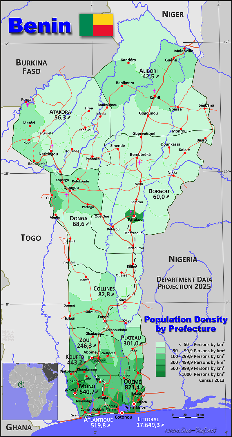
Benin - Click on the map to get a enlarged image in PDF format!
Other language versions are easy to generate, the description is in an own layer
Conditions for thematic maps with your own data and logotype
Delivery as printable file by e-mail or plot by post office |
|---|
| Layer | |
| Province: | yes |
| Streets: | yes |
| Infrastructure: | yes |
| Rivers: | yes |
|
| Size | bis A2 |
| Supply in | 7 working days |
| Price |
| 1 bis 3 | 75 € |
| > 3 | On request |
|
 |
All information published herein is free usable quoting the source,
including the maps, if they are not modified |
|---|
Statistical Data - Population density according to the administrative structure
The population data in the table below is an estimation for 2025, based on the census data from 2013.
Click on the column header brings the table in order of the column header. The default order is the Department name.
| Department |
ISO
3166-2 |
Capital |
Area
(km²) |
Population |
Density
(pers/km²) |
|---|
| Total |
|
|
114 763 |
14 192 247 |
123,7 |
|---|
| Last update: 11/04/2020 - 00:43:46 |
| Alibori |
BJ-AL |
Kandi |
26 242 |
1 092 404 |
41,6 |
| Atakora |
BJ-AK |
Natitingou |
20 499 |
1 151 782 |
56,2 |
| Atlantique |
BJ-AQ |
Ouidah |
3 233 |
1 680 624 |
519,8 |
| Borgou |
BJ-BO |
Parakou |
25 856 |
1 518 131 |
58,7 |
| Collines |
BJ-CO |
Savalou |
13 931 |
1 123 493 |
80,6 |
| Donga |
BJ-KO |
Djougou |
11 126 |
733 860 |
66,0 |
| Kouffo |
BJ-DO |
Dogbo-Tota |
2 404 |
1 099 727 |
457,5 |
| Littoral |
BJ-LI |
Cotonou |
79 |
1 394 296 |
17 649,3 |
| Mono |
BJ-MO |
Lokossa |
1 605 |
754 771 |
470,3 |
| Ouémé |
BJ-OU |
Porto Novo |
1 281 |
1 531 969 |
1 195,9 |
| Plateau |
BJ-PL |
Sakété |
3 264 |
853 466 |
261,5 |
| Zou |
BJ-ZO |
Abomey |
5 243 |
1 257 726 |
239,9 |
The departments are divided into prefectures, the data of which are shown in the table below. The data is from 2013, there are no more recent data.
| Prefecture |
HASC |
Department |
Capital |
Area
(km²) |
Population |
Density
(pers/km²) |
|---|
| Total |
|
|
|
114 763 |
10 008 749 |
87,2 |
|---|
| Last update: 11/04/2020 - 00:43:46 |
| Abomey |
ZO.AB |
Zou |
Abomey |
142 |
92 266 |
649,8 |
| Abomey-Calavi |
AQ.AC |
Atlantique |
Abomey-Calavi |
539 |
656 358 |
1 217,7 |
| Adja-Ouèrè |
PL.AO |
Plateau |
Adja-Ouèrè |
415 |
116 282 |
280,2 |
| Adjarra |
OU.AA |
Ouémé |
Adjarra |
75 |
97 424 |
1 299,0 |
| Adjohoun |
OU.AH |
Ouémé |
Adjohoun |
279 |
75 323 |
270,0 |
| Agbangnizoun |
ZO.AG |
Zou |
Agbangnizoun |
244 |
72 549 |
297,3 |
| Aguégués |
OU.AG |
Ouémé |
Aguégués |
103 |
44 562 |
432,6 |
| Akpro-Missérété |
OU.AM |
Ouémé |
Akpro-Missérété |
79 |
127 249 |
1 610,7 |
| Allada |
AQ.AL |
Atlantique |
Allada |
381 |
127 512 |
334,7 |
| Aplahoué |
CF.AP |
Couffo |
Aplahoué |
915 |
171 109 |
187,0 |
| Athiémé |
MO.AT |
Mono |
Athiémé |
238 |
56 483 |
237,3 |
| Avrankou |
OU.AV |
Ouémé |
Avrankou |
78 |
128 050 |
1 641,7 |
| Banikoara |
AL.BA |
Alibori |
Banikoara |
4 383 |
246 575 |
56,3 |
| Bantè |
CL.BA |
Collines |
Bantè |
2 675 |
107 181 |
40,1 |
| Bassila |
DO.BA |
Donga |
Bassila |
5 661 |
130 091 |
23,0 |
| Bembéréké |
BO.BE |
Borgou |
Bembéréké |
3 348 |
131 255 |
39,2 |
| Bohicon |
ZO.BO |
Zou |
Bohicon |
139 |
171 781 |
1 235,8 |
| Bonou |
OU.BO |
Ouémé |
Bonou |
250 |
44 349 |
177,4 |
| Bopa |
MO.BO |
Mono |
Bopa |
365 |
96 281 |
263,8 |
| Boukoumbé |
AK.BO |
Atacora |
Boukoumbé |
1 036 |
82 450 |
79,6 |
| Cobly |
AK.CB |
Atacora |
Cobly |
825 |
67 603 |
81,9 |
| Comè |
MO.CO |
Mono |
Comè |
163 |
79 989 |
490,7 |
| Copargo |
DO.CP |
Donga |
Copargo |
876 |
70 938 |
81,0 |
| Cotonou |
LI.CO |
Cotonou |
Cotonou |
79 |
679 012 |
8 595,1 |
| Covè |
ZO.CO |
Zou |
Covè |
418 |
51 247 |
122,6 |
| Dagbo |
OU.DA |
Ouémé |
Dangbo |
149 |
96 426 |
647,2 |
| Dassa-Zoumé |
CL.DZ |
Collines |
Dassa-Zoumé |
1 711 |
112 122 |
65,5 |
| Djakotomey |
CF.DJ |
Couffo |
Djakotomey |
235 |
134 028 |
570,3 |
| Djidja |
ZO.DJ |
Zou |
Djidja |
2 184 |
123 542 |
56,6 |
| Djougou |
DO.DJ |
Donga |
Djougou |
3 926 |
267 812 |
68,2 |
| Dogbo |
CF.DO |
Couffo |
Dogbo |
308 |
103 057 |
334,6 |
| Glazoué |
CL.GL |
Collines |
Glazoué |
1 764 |
124 431 |
70,5 |
| Gogounou |
AL.GO |
Alibori |
Gogounou |
4 910 |
117 523 |
23,9 |
| Grand-Popo |
MO.GP |
Mono |
Grand-Popo |
289 |
57 636 |
199,4 |
| Houéyogbé |
MO.HO |
Mono |
Houéyogbé |
290 |
101 893 |
351,4 |
| Ifangni |
PL.IF |
Plateau |
Ifangni |
242 |
110 973 |
458,6 |
| Kalalé |
BO.KL |
Borgou |
Kalalé |
3 586 |
168 882 |
47,1 |
| Kandi |
AL.KN |
Alibori |
Kandi |
3 421 |
179 290 |
52,4 |
| Karimama |
AL.KR |
Alibori |
Karimama |
6 041 |
66 353 |
11,0 |
| Kérou |
AK.KE |
Atacora |
Kérou |
3 745 |
100 197 |
26,8 |
| Kétou |
PL.KE |
Plateau |
Kétou |
1 775 |
157 352 |
88,6 |
| Klouékanmè |
CF.KL |
Couffo |
Klouékanmè |
394 |
128 597 |
326,4 |
| Kouandé |
AK.KO |
Atacora |
Kouandé |
3 269 |
111 540 |
34,1 |
| Kpomassè |
AQ.KP |
Atlantique |
Kpomassè |
295 |
67 648 |
229,3 |
| Lalo |
CF.LA |
Couffo |
Lalo |
432 |
119 926 |
277,6 |
| Lokossa |
MO.LO |
Mono |
Lokossa |
260 |
104 961 |
403,7 |
| Malanville |
AL.MA |
Alibori |
Malanville |
3 016 |
168 641 |
55,9 |
| Matéri |
AK.MA |
Atacora |
Matéri |
1 740 |
113 958 |
65,5 |
| Natitingou |
AK.NA |
Atacora |
Natitingou |
1 339 |
103 843 |
77,6 |
| N'Dali |
BO.ND |
Borgou |
N'Dali |
3 748 |
113 604 |
30,3 |
| Nikki |
BO.NI |
Borgou |
Nikki |
3 171 |
151 232 |
47,7 |
| Ouaké |
DO.OU |
Donga |
Ouaké |
663 |
74 289 |
112,0 |
| Ouèssè |
CL.OS |
Collines |
Ouèssè |
2 879 |
142 017 |
49,3 |
| Ouidah |
AQ.OU |
Atlantique |
Ouidah |
336 |
162 034 |
482,2 |
| Ouinhi |
ZO.ON |
Zou |
Ouinhi |
342 |
59 381 |
173,6 |
| Parakou |
BO.PA |
Borgou |
Parakou |
441 |
255 478 |
579,3 |
| Pehonko |
AK.PE |
Atacora |
Pehonko |
2 014 |
78 217 |
38,8 |
| Pèrèrè |
BO.PE |
Borgou |
Pèrèrè |
2 017 |
78 988 |
39,2 |
| Pobè |
PL.PB |
Plateau |
Pobè |
400 |
123 677 |
309,2 |
| Porto-Novo |
OU.PN |
Ouémé |
Porto-Novo |
50 |
264 320 |
5 286,4 |
| Sakété |
PL.SA |
Plateau |
Sakété |
432 |
114 088 |
264,1 |
| Savalou |
CL.SL |
Collines |
Savalou |
2 674 |
144 549 |
54,1 |
| Savé |
CL.SE |
Collines |
Savé |
2 228 |
87 177 |
39,1 |
| Ségbana |
AL.SE |
Alibori |
Ségbana |
4 471 |
89 081 |
19,9 |
| Sèmè-Kpodji |
OU.SK |
Ouémé |
Sèmè-Kpodji |
218 |
222 701 |
1 021,6 |
| Sinendé |
BO.SI |
Borgou |
Sinendé |
2 289 |
91 672 |
40,0 |
| Sô-Ava |
AQ.SA |
Atlantique |
Sô-Ava |
209 |
118 547 |
567,2 |
| Tanguiéta |
AK.TA |
Atacora |
Tanguiéta |
5 456 |
74 675 |
13,7 |
| Tchaourou |
BO.TC |
Borgou |
Tchaourou |
7 256 |
223 138 |
30,8 |
| Toffo |
AQ.TF |
Atlantique |
Toffo |
492 |
101 585 |
206,5 |
| Tori-Bossito |
AQ.TB |
Atlantique |
Tori-Bossito |
328 |
57 632 |
175,7 |
| Toucountouna |
AK.TO |
Atacora |
Toucountouna |
1 075 |
39 779 |
37,0 |
| Toviklin |
CF.TO |
Couffo |
Toviklin |
120 |
88 611 |
738,4 |
| Za-Kpota |
ZO.ZK |
Zou |
Za-Kpota |
409 |
132 818 |
324,7 |
| Zangnanado |
ZO.ZN |
Zou |
Zangnanado |
540 |
55 061 |
102,0 |
| Zè |
AQ.ZE |
Atlantique |
Zè |
653 |
106 913 |
163,7 |
| Zogbodomey |
ZO.ZB |
Zou |
Zogbodomey |
825 |
92 935 |
112,6 |
Membership in international organisations and treaties
Expand list
Political Alliances
Regional Unions
Military alliances/Arms control
Law enforcement
Business Alliances
Fishery
Financial
Free Trade Area, Internal Market
Technical alliances
Transport
Cientific
Humanitarian Unions
Cultural Unions
 |
If you have suggestions to include other information or you find missed links, please inform us!
Click here ... |
International Border disputes
Expand list
|
Fast selection
List of international
organisations
and treaties
Existing
thematical maps
|
