| |
| Capital |
Currency | Government system |
|---|
| none |
Different |
Different claims |
| Official language | Region |
Population |
|---|
Chinese
Japanese |
Far East |
0 |
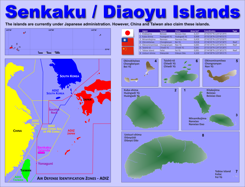
Country map - Administrative structure - Population density of Senkaku Islands
Senkaku Islands - Click on the map to get a enlarged image in PDF format!
Other language versions are easy to generate, the description is in an own layer
Conditions for thematic maps with your own data and logotype
Delivery as printable file by e-mail or plot by post office |
|---|
| Layer | |
| Province: | yes |
| Streets: | no |
| Infrastructure: | no |
| Rivers: | yes |
|
| Size | bis A2 |
| Supply in | 7 working days |
| Price |
| 1 bis 3 | 60 € |
| > 3 | On request |
|
 |
| Observation |
Contested between China, Taiwan and Japan |
All information published herein is free usable quoting the source,
including the maps, if they are not modified |
|---|
Statistical Data - Population density according to the administrative structure
The islands are not populated. (2021)
The order of the islands
corresponds to the graph above.
| Island name in |
Area
(km²) |
Coordinates |
|---|
| Japan |
Taiwan |
China |
| |
|
|
6,100 |
|
|---|
| Updated: 08.09.2023 - 16:30:34 |
| Kitakojima |
Beixiao |
Beixiao Dao |
0,327 |
25°43'47"N 123°32'29"E |
| Kuba-shima |
Huángwei Yu |
Huángwei Yu |
0,909 |
25°55'26"N 123°40'55"E |
| Minamikojima |
Nanxiao |
Nanxiao Dao |
0,459 |
25°43'25"N 123°33'00"E |
| Okinokitaiwa |
Chongbeiyan |
Bei Yu |
0,018 |
25°46'45"N 123°32'30"E |
| Okinominamiiwa |
Chongnanyan |
Nan Yu |
0,005 |
25°45'19"N 123°34'01"E |
| Taishō-tō |
Chìwei Yu |
Chìwei Yu |
0,061 |
25°55'20"N 124°33'28"E |
| Tobise Island |
Feilai |
Fei Yu |
0,001 |
25°44'08"N 123°30'22"E |
| Uotsuri-shima |
Diàoyútái |
Diàoyú Dao |
4,320 |
25°44'39"N 123°28'21"E |
|
Fast selection
List of international
organisations
and treaties
Existing
thematical maps
|

