| |
| Capital |
Currency | Government system |
|---|
| Puerto Ayora |
US-Dollar (USD) |
Dependent from Ecuador |
| Official language | Region |
Population |
|---|
| Spanish |
South America |
Census 2022 - 28 583 |
Country map - Administrative structure - Population density of Galapagos Islands
Galapagos Islands - Click on the map to get a enlarged image in PDF format!
Other language versions are easy to generate, the description is in an own layer
Conditions for thematic maps with your own data and logotype
Delivery as printable file by e-mail or plot by post office |
|---|
| Layer | |
| Province: | yes |
| Streets: | yes |
| Infrastructure: | yes |
| Rivers: | yes |
|
| Size | bis A2 |
| Supply in | 7 working days |
| Price |
| 1 bis 3 | 65 € |
| > 3 | On request |
|
 |
| Observation |
Part of Ecuador |
All information published herein is free usable quoting the source,
including the maps, if they are not modified |
|---|
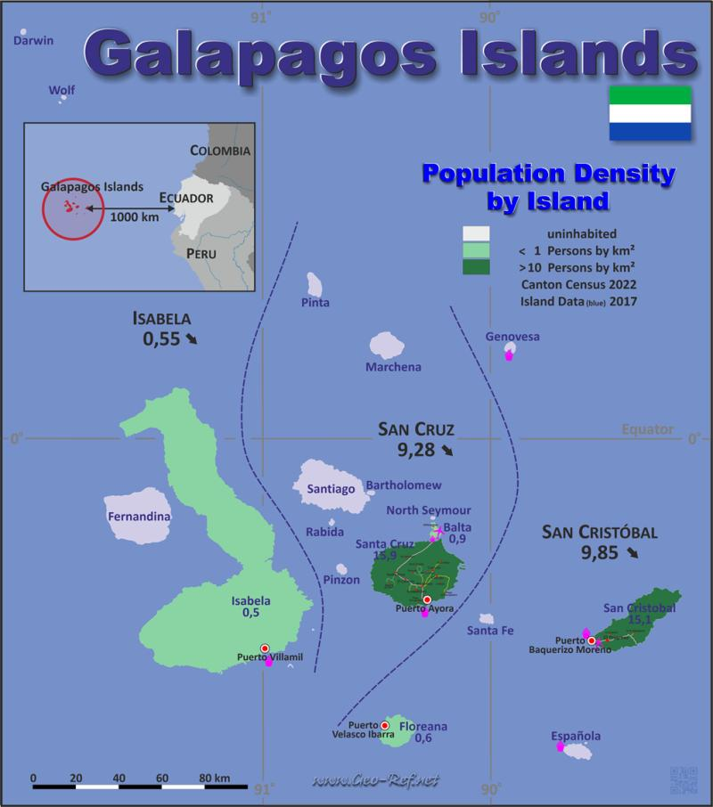
Statistical Data - Population density according to the administrative structure
The population data in the table below is the census data from 2022, last available data.
ISO values are only defined for the Canton structure
Click on the column header brings the table in order of the column header. The default order is the Canton name.
| Canton |
ISO
3166-2 |
Capital |
Area
(km²) |
Population |
Density
(pers/km²) |
|---|
| Total |
|
|
8 228 |
28 583 |
3 47 |
|---|
| Last update: 01/16/2024 - 22:31:40 |
| Isabela |
EC-W-I |
Puerto Villamil |
5 527 |
3 050 |
0 55 |
| San Cristóbal |
EC-W-SI |
Puerto Baquerizo Moreno |
843 |
8 300 |
9 85 |
| Santa Cruz |
EC-W-SC |
Puerto Ayora |
1 858 |
17 233 |
9 28 |
In the folloing table the Cantons are splitted into the islands. Island data 2017.
| Island |
ISO
3166-2 |
Canton |
Capital |
Area
(km²) |
Population |
Density
(pers/km²) |
|---|
| Total |
|
|
|
7 967 |
26 424 |
3 3 |
|---|
| Last update: 01/16/2024 - 22:31:40 |
| Baltra |
n.d. |
Santa Cruz |
- |
27 |
23 |
0 9 |
| Bartolomé |
n.d. |
Santa Cruz |
- |
1 |
0 |
0 0 |
| Darwin |
n.d. |
Isabela |
- |
1 |
0 |
0 0 |
| Española |
n.d. |
San Cristóbal |
- |
60 |
0 |
0 0 |
| Fernandina |
n.d. |
Isabela |
- |
643 |
0 |
0 0 |
| Floreana |
n.d. |
San Cristóbal |
Puerto Velasco Ibarra |
173 |
100 |
0 6 |
| Genovesa |
n.d. |
San Cristóbal |
- |
14 |
0 |
0 0 |
| Isabela |
n.d. |
Isabela |
Puerto Villamil |
4 670 |
2 200 |
0 5 |
| Marchena |
n.d. |
Santa Cruz |
- |
139 |
0 |
0 0 |
| North Seymour |
n.d. |
Santa Cruz |
- |
2 |
0 |
0 0 |
| Pinta |
n.d. |
Santa Cruz |
- |
59 |
0 |
0 0 |
| Pinzón |
n.d. |
Santa Cruz |
- |
18 |
0 |
0 0 |
| Rábida |
n.d. |
Santa Cruz |
- |
5 |
0 |
0 0 |
| San Cristóbal |
n.d. |
San Cristóbal |
Puerto Baquerizo Moreno |
558 |
8 400 |
15 1 |
| Santa Cruz |
n.d. |
Santa Cruz |
Puerto Ayora |
986 |
15 701 |
15 9 |
| Santa Fe |
n.d. |
San Cristóbal |
- |
24 |
0 |
0 0 |
| Santiago |
n.d. |
Santa Cruz |
- |
585 |
0 |
0 0 |
| Wolf |
n.d. |
Isabela |
- |
1 |
0 |
0 0 |
|
Fast selection
List of international
organisations
and treaties
Existing
thematical maps
|

