| |
Overseas region & department of France La Reunión´
|
| Capital |
Currency | Government system |
|---|
| Saint-Denis |
Euro (EUR) |
Dependent from France |
| Official language | Region |
Population |
|---|
| French |
Africa |
Estimation 2021 - 871 157 |
Country map - Administrative structure - Population density of Reunion
Reunion - Click on the map to get a enlarged image in PDF format!
Other language versions are easy to generate, the description is in an own layer
Conditions for thematic maps with your own data and logotype
Delivery as printable file by e-mail or plot by post office |
|---|
| Layer | |
| Province: | yes |
| Streets: | yes |
| Infrastructure: | yes |
| Rivers: | yes |
|
| Size | bis A2 |
| Supply in | 7 working days |
| Price |
| 1 bis 3 | 65 € |
| > 3 | On request |
|
 |
All information published herein is free usable quoting the source,
including the maps, if they are not modified |
|---|
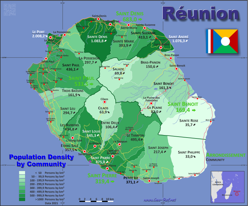
Statistical Data - Population density according to the administrative structure
The population data in the table below is a estimation for 2021.
An ISO code for the administrative units is not defined. The INSEE code was used for the subdivision.
Click on the column header brings the table in order of the column header. The default order is the Arrondissement name.
| Arrondissement |
INSEE |
Communes |
Capital |
Area
(km²) |
Population |
Density
(pers/km²) |
|---|
| Total |
|
|
|
2 504,9 |
871 157 |
347,8 |
|---|
| Last update: 27/05/2025 - 15:43:01 |
| Saint-Benoît |
9741 |
6 |
Saint-Benoît |
735,9 |
127 924 |
169,4 |
| Saint-Denis |
9743 |
3 |
Saint-Denis |
288,8 |
213 402 |
683,0 |
| Saint-Paul |
9744 |
5 |
Saint-Paul |
537,3 |
215 613 |
533,5 |
| Saint-Pierre |
9742 |
10 |
Saint-Pierre |
942,9 |
314 218 |
319,4 |
The following table shows the municipalities by Arrondissement . Since there are no ISO specification defined, the INSEE code was used for the subdivisions.
| Community |
INSEE |
Arrondissement |
Capital |
Area
(km²) |
Population |
Density
(pers/km²) |
|---|
| Total |
|
|
|
2 504,9 |
871 157 |
347,8 |
|---|
| Last update: 27/05/2025 - 15:43:01 |
| Bras-Panon |
97402 |
Saint-Benoît |
Bras-Panon |
88,6 |
13 344 |
150,6 |
| Cilaos |
97413 |
Saint-Pierre |
Cilaos |
84,4 |
5 390 |
63,9 |
| Entre-Deux |
97403 |
Saint-Pierre |
Entre-Deux |
66,8 |
7 105 |
106,4 |
| Étang-Salé |
97404 |
Saint-Pierre |
Étang-Salé |
38,7 |
13 836 |
357,5 |
| La Plaine |
97406 |
Saint-Benoît |
La Plaine |
83,2 |
6 821 |
82,0 |
| La Possession |
97408 |
Saint-Paul |
La Possession |
118,4 |
35 245 |
297,7 |
| Le Port |
97407 |
Saint-Paul |
Le Port |
16,6 |
33 336 |
2 008,2 |
| Le Tampon |
97422 |
Saint-Pierre |
Le Tampon |
165,4 |
81 943 |
495,4 |
| Les Avirons |
97401 |
Saint-Pierre |
Les Avirons |
26,3 |
11 434 |
434,8 |
| Petite-Ile |
97405 |
Saint-Pierre |
Petite-Ile |
34,0 |
12 617 |
371,1 |
| Saint-André |
97409 |
Saint-Benoît |
Saint-André |
53,1 |
57 150 |
1 076,3 |
| Saint-Benoît |
97410 |
Saint-Benoît |
Saint-Benoît |
229,6 |
37 023 |
161,3 |
| Saint-Denis |
97411 |
Saint-Denis |
Saint-Denis |
142,8 |
154 765 |
1 083,8 |
| Saint-Joseph |
97412 |
Saint-Pierre |
Saint-Joseph |
178,5 |
38 807 |
217,4 |
| Saint-Leu |
97436 |
Saint-Paul |
Saint-Leu |
118,4 |
34 893 |
294,7 |
| Saint-Louis |
97414 |
Saint-Pierre |
Saint-Louis |
98,9 |
53 935 |
545,3 |
| Saint-Paul |
97415 |
Saint-Paul |
Saint-Paul |
241,3 |
105 240 |
436,1 |
| Saint-Philippe |
97417 |
Saint-Pierre |
Saint-Philippe |
153,9 |
5 074 |
33,0 |
| Saint-Pierre |
97416 |
Saint-Pierre |
Saint-Pierre |
96,0 |
84 077 |
875,8 |
| Sainte-Marie |
97418 |
Saint-Denis |
Sainte-Marie |
87,2 |
34 344 |
393,9 |
| Sainte-Rose |
97419 |
Saint-Benoît |
Sainte-Rose |
177,6 |
6 343 |
35,7 |
| Sainte-Suzanne |
97441 |
Saint-Denis |
Sainte-Suzanne |
58,8 |
24 293 |
413,1 |
| Salazie |
97421 |
Saint-Benoît |
Salazie |
103,8 |
7 243 |
69,8 |
| Trois-Bassins |
97423 |
Saint-Paul |
Trois-Bassins |
42,6 |
6 899 |
161,9 |
Membership in international organisations and treaties
Expand list
 |
If you have suggestions to include other information or you find missed links, please inform us!
Click here ... |
International Border disputes
Expand list
|
Fast selection
List of international
organisations
and treaties
Existing
thematical maps
|
