| |
| Capital |
Currency | Government system |
|---|
| Nouméa |
CFP Francs (XPF) |
Dependent from France |
| Official language | Region |
Population |
|---|
| French |
Australia & Oceania |
Census 2025 - 264 596 |
Country map - Administrative structure - Population density of New Caledonia
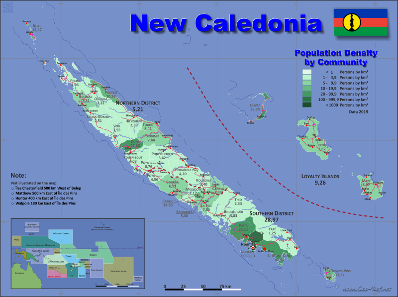
New Caledonia - Click on the map to get a enlarged image in PDF format!
Other language versions are easy to generate, the description is in an own layer
Conditions for thematic maps with your own data and logotype
Delivery as printable file by e-mail or plot by post office |
|---|
| Layer | |
| Province: | yes |
| Streets: | yes |
| Infrastructure: | yes |
| Rivers: | yes |
|
| Size | bis A2 |
| Supply in | 7 working days |
| Price |
| 1 bis 3 | 75 € |
| > 3 | On request |
|
 |
All information published herein is free usable quoting the source,
including the maps, if they are not modified |
|---|
Statistical Data - Population density according to the administrative structure
The population data in the table below is the census data from 2025, last available data.
Click on the column header brings the table in order of the column header. The default order is the District name.
| District |
INSEE |
Capital |
Area
(km²) |
Population |
Density
(pers/km²) |
|---|
| Total |
|
|
18 575,5 |
264 596 |
14,24 |
|---|
| Last update: 11/04/2020 - 00:43:50 |
| Loyalty Islands |
NC-LI |
Wé |
1 980,9 |
18 671 |
9,43 |
| North |
NC-NO |
Koné |
9 582,6 |
50 947 |
5,32 |
| South |
NC-SO |
Nouméa |
7 012,0 |
194 978 |
27,81 |
The following table shows the municipalities by district. Since there are no ISO specification defined, the postal code was used for the subdivisions.
| Community |
INSEE |
District |
Capital |
Area
(km²) |
Population |
Density
(pers/km²) |
|---|
| Total |
|
|
|
18 575,5 |
264 596 |
14,2 |
|---|
| Last update: 11/04/2020 - 00:43:50 |
| Belep |
98801 |
North |
Waala |
69,5 |
686 |
9,9 |
| Bouloupari |
98802 |
South |
Bouloupari |
865,6 |
3 359 |
3,9 |
| Bourail |
98803 |
South |
Bourail |
797,6 |
5 575 |
7,0 |
| Canala |
98804 |
North |
Canala |
438,7 |
3 911 |
8,9 |
| Dumbéa |
98805 |
South |
Dumbéa |
254,6 |
34 926 |
137,2 |
| Farino |
98806 |
South |
Farino |
48,0 |
736 |
15,3 |
| Hienghène |
98807 |
North |
Hienghène |
1 068,8 |
2 455 |
2,3 |
| Houaïlou |
98808 |
North |
Houaïlou |
940,6 |
3 756 |
4,0 |
| Kaala-Gomen |
98810 |
North |
Kaala-Gomen |
718,2 |
2 112 |
2,9 |
| Koné |
98811 |
North |
Koné |
373,6 |
8 048 |
21,5 |
| Kouaoua |
98833 |
North |
Kouaoua |
383,0 |
1 335 |
3,5 |
| Koumac |
98812 |
North |
Koumac |
550,0 |
4 272 |
7,8 |
| La Foa |
98813 |
South |
La Foa |
464,0 |
3 449 |
7,4 |
| Le Mont-Dore |
98817 |
South |
Le Mont-Dore |
643,0 |
25 303 |
39,4 |
| Lifou |
98814 |
Loyalty Islands |
Wé |
1 207,1 |
9 225 |
7,6 |
| L'Île-des-Pins |
98809 |
South |
Vao |
152,3 |
2 050 |
13,5 |
| Maré |
98815 |
Loyalty Islands |
Tadine |
641,7 |
6 284 |
9,8 |
| Moindou |
98816 |
South |
Moindou |
321,9 |
944 |
2,9 |
| Nouméa |
98818 |
South |
Nouméa |
45,7 |
85 976 |
1 881,3 |
| Ouégoa |
98819 |
North |
Ouégoa |
656,8 |
2 409 |
3,7 |
| Ouvéa |
98820 |
Loyalty Islands |
Fayaoué |
132,1 |
3 162 |
23,9 |
| Païta |
98821 |
South |
Païta |
699,7 |
27 609 |
39,5 |
| Poindimié |
98822 |
North |
Poindimié |
673,1 |
4 613 |
6,9 |
| Ponérihouen |
98823 |
North |
Ponérihouen |
707,3 |
2 332 |
3,3 |
| Pouébo |
98824 |
North |
Pouébo |
202,8 |
2 292 |
11,3 |
| Pouembout |
98825 |
North |
Pouembout |
674,3 |
3 062 |
4,5 |
| Poum |
98826 |
North |
Poum |
469,4 |
1 597 |
3,4 |
| Poya (part north) |
98827 |
South |
Poya (part south) |
277,2 |
301 |
1,1 |
| Poya (part south) |
98827 |
North |
Poya (part north) |
568,6 |
2 661 |
4,7 |
| Sarraméa |
98828 |
South |
Sarraméa |
106,4 |
581 |
5,5 |
| Thio |
98829 |
South |
Thio |
997,6 |
2 581 |
2,6 |
| Touho |
98830 |
North |
Touho |
283,0 |
2 284 |
8,1 |
| Voh |
98831 |
North |
Voh |
804,9 |
3 122 |
3,9 |
| Yaté |
98832 |
South |
Yaté |
1 338,4 |
1 588 |
1,2 |
Membership in international organisations and treaties
Expand list
Regional Unions
Technical alliances
Environment
Cientific
Cultural Unions
 |
If you have suggestions to include other information or you find missed links, please inform us!
Click here ... |
|
Fast selection
List of international
organisations
and treaties
Existing
thematical maps
|
