| |
| Capital |
Currency | Government system |
|---|
| Douglas |
Pound Sterling (GBP) |
Crown dependency of the UK |
| Official language | Region |
Population |
|---|
Manx
English |
Europe |
Census 2021 - 84 069 |
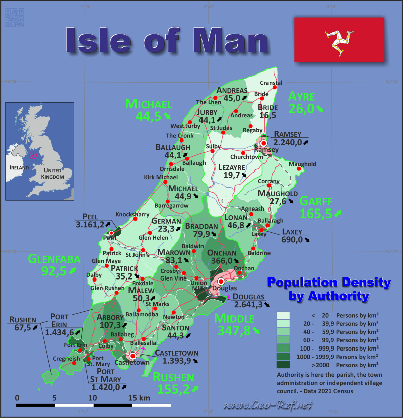
Country map - Administrative structure - Population density of Isle of Man
Isle of Man - Click on the map to get a enlarged image in PDF format!
Other language versions are easy to generate, the description is in an own layer
Conditions for thematic maps with your own data and logotype
Delivery as printable file by e-mail or plot by post office |
|---|
| Layer | |
| Province: | yes |
| Streets: | yes |
| Infrastructure: | yes |
| Rivers: | yes |
|
| Size | bis A2 |
| Supply in | 7 working days |
| Price |
| 1 bis 3 | 80
60 |
| > 3 | On request |
|
 |
All information published herein is free usable quoting the source,
including the maps, if they are not modified |
|---|
Statistical Data - Population density according to the administrative structure
The population data in the table below is the census data from 2021, last available data.
There is no ISO sub-division, therefore was used the HASC codification.
Click on the column header brings the table in order of the column header. The default order is the Sheading name.
| Sheading |
HASC |
Capital |
Area
(km²) |
Population |
Density
(pers/km²) |
|---|
| Total |
|
|
572,0 |
84 069 |
147,0 |
|---|
| Last update: 01/16/2024 - 22:31:37 |
| Ayre |
IM.AY |
Bride |
115,1 |
2 989 |
26,0 |
| Garff |
IM.GR |
Ramsey |
75,8 |
12 543 |
165,5 |
| Glenfaba |
IM.GB |
Peel |
89,2 |
8 253 |
92,5 |
| Michael |
IM.MC |
Michael |
75,2 |
3 343 |
44,5 |
| Middle |
IM.MD |
Douglas |
121,0 |
42 089 |
347,8 |
| Rushen |
IM.RU |
Castletown |
95,7 |
14 852 |
155,2 |
The sheadings are composed of administrative authorities, which are city administrations, counties or village administrations.
| Authority |
HASC |
Sheading |
Capital |
Area
(km²) |
Population |
Density
(pers/km²) |
|---|
| Total |
|
|
|
572,0 |
84 069 |
147,0 |
|---|
| Last update: 01/16/2024 - 22:31:37 |
| Andreas |
AY.AN |
Ayre |
Andreas |
31,1 |
1 400 |
45,0 |
| Arbory |
RU.AB |
Rushen |
Ballabeg |
17,7 |
1 899 |
107,3 |
| Ballaugh |
MC.BL |
Michael |
Ballaugh |
23,6 |
1 041 |
44,1 |
| Braddan |
MD.BN |
Middle |
Union Mills |
42,6 |
3 404 |
79,9 |
| Bride |
AY.BE |
Ayre |
Bride |
21,7 |
359 |
16,5 |
| Castletown |
RU.CA |
Rushen |
Castletown |
2,3 |
3 206 |
1 393,9 |
| Douglas |
MD.DO |
Middle |
Douglas |
10,1 |
26 677 |
2 641,3 |
| German |
GB.GE |
Glenfaba |
Glen Helen |
45,3 |
1 056 |
23,3 |
| Jurby |
MC.JU |
Michael |
West Jurby |
17,7 |
780 |
44,1 |
| Laxey |
GR.LX |
Garff |
Laxey |
2,4 |
1 656 |
690,0 |
| Lezayre |
AY.LZ |
Ayre |
Sulby |
62,3 |
1 230 |
19,7 |
| Lonan |
GR.LN |
Garff |
Baldrine |
35,2 |
1 647 |
46,8 |
| Malew |
RU.ML |
Rushen |
Ballasalla |
47,1 |
2 367 |
50,3 |
| Marown |
MD.MR |
Middle |
Glen Vine |
26,7 |
2 220 |
83,1 |
| Maughold |
GR.MG |
Garff |
Maughold |
34,5 |
952 |
27,6 |
| Michael |
MC.MC |
Michael |
Michael |
33,9 |
1 522 |
44,9 |
| Onchan |
MD.ON |
Middle |
Onchan |
24,7 |
9 039 |
366,0 |
| Patrick |
GB.PT |
Glenfaba |
Patrick |
42,2 |
1 487 |
35,2 |
| Peel |
GB.PL |
Glenfaba |
Peel |
1,7 |
5 710 |
3 358,8 |
| Port Erin |
RU.PE |
Rushen |
Port Erin |
2,6 |
3 730 |
1 434,6 |
| Port St Mary |
RU.PS |
Rushen |
Port St Mary |
1,4 |
1 989 |
1 420,7 |
| Ramsey |
AY.RA |
Garff |
Ramsey |
3,7 |
8 288 |
2 240,0 |
| Rushen |
RU.RU |
Rushen |
Cregneash |
24,6 |
1 661 |
67,5 |
| Santon |
MD.SA |
Middle |
Newtown |
16,9 |
749 |
44,3 |
Membership in international organisations and treaties
Expand list
Free Trade Area, Internal Market
Technical alliances
Cultural Unions
 |
If you have suggestions to include other information or you find missed links, please inform us!
Click here ... |
|
Fast selection
List of international
organisations
and treaties
Existing
thematical maps
|
