Mobil Version header


British Overseas Territory Saint Helena

Capital CurrencyGovernment system
Jamestown Pound Sterling (GBP) Dependent from UK
Official languageRegion Population
English Africa 2020 .- 966

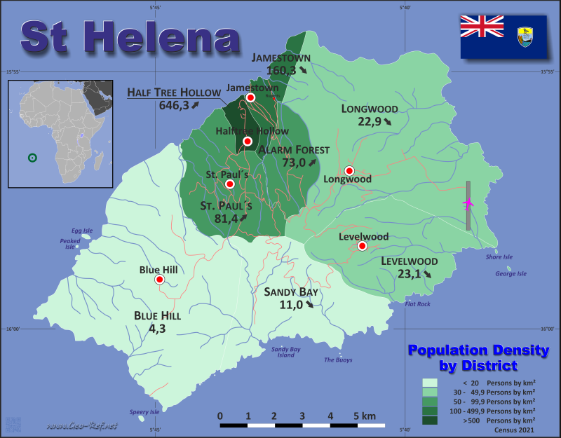
Country map - Administrative structure - Population density of Saint Helena

Map Saint Helena - Administrative division - Population density 2020

Saint Helena - Click on the map to get a enlarged image in PDF format!

Other language versions are easy to generate, the description is in an own layer

Conditions for thematic maps with your own data and logotype
Delivery as printable file by e-mail or plot by post office
Layer 
Province:yes
Streets:yes
Infrastructure:yes
Rivers:yes
Sizebis A2
Supply in7 working days
Price
1 bis 360 €
> 3On request
Buy
All information published herein is free usable quoting the source,
including the maps, if they are not modified

Statistical Data - Population density according to the administrative structure

The population data in the table below is the census data from 2021, last available data.

Click on the column header brings the table in order of the column header. The default order is the District name.

District ISO
3166-2
Capital Area
(km²)
Population Density
(pers/km²)
Total     123,4 4.545 36,8
Last update: 23/08/2023 - 21:24:45
Alarm Forest n.d. Alarm Forest 5,4 383 70,9
Blue Hill n.d. Blue Hill 36,8 158 4,3
Half Tree Hollow n.d. Halftree Hollow 1,6 984 615,0
Jamestown n.d. Jamestown 3,9 629 161,3
Jamestown Harbour n.d. - 13 -
Levelwood n.d. Levelwood 14,8 369 24,9
Longwood n.d. Longwood 33,4 790 23,7
Royal Mail Ship St. Helena n.d. - 183 -
Saint Paul's n.d. Saint Paul's 11,4 843 73,9
Sandy Bay n.d. 16,1 193 12,0


Membership in international organisations and treaties

Expand list

Technical alliances


Broken Link

If you have suggestions to include other information or you find missed links, please inform us! Click here ...


See also neighboring states

Great Britain


Fast selection


List of international
organisations
and treaties


Existing
thematical maps

  • Poulation density for 2021

Link-Collection

Country data

Official Web-Portal

St Helena Government Website

National Media

National Holydays
in German

Wikipedia

CIA - World Factbook


International data

UN-Data

UNCTAD


Special data

FAO - Statistics

UN Environment

IRENA
Alternative Energy

relief
Disaster/Risk data


External links change quickly - If you get a link error - Please inform us!

Broken Link Report