| |
| Capital |
Currency | Government system |
|---|
| St. Peter Port |
Pound Sterling (GBP) |
Crown dependency of the UK |
| Official language | Region |
Population |
|---|
English
Frech |
Europe |
Estimation 2023 - 66 419 |
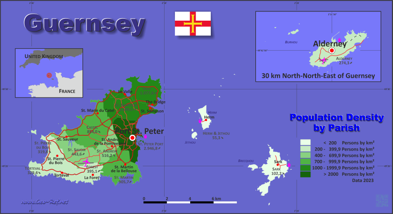
Country map - Administrative structure - Population density of Guernsey
Guernsey - Click on the map to get a enlarged image in PDF format!
Other language versions are easy to generate, the description is in an own layer
Conditions for thematic maps with your own data and logotype
Delivery as printable file by e-mail or plot by post office |
|---|
| Layer | |
| Province: | yes |
| Streets: | yes |
| Infrastructure: | yes |
| Rivers: | yes |
|
| Size | bis A2 |
| Supply in | 7 working days |
| Price |
| 1 bis 3 | 70 € |
| > 3 | On request |
|
 |
All information published herein is free usable quoting the source,
including the maps, if they are not modified |
|---|
Statistical Data - Population density according to the administrative structure
The population data in the table below is a estimation for 2023.
Click on the column header brings the table in order of the column header. The default order is the Parish name.
| Parish |
ISO
3166-2 |
Capital |
Area
(km²) |
Population |
Density
(pers/km²) |
|---|
| Total |
|
|
78,48 |
66 419 |
846,3 |
|---|
| Last update: 15/05/2024 - 23:44:55 |
| Alderney |
GGY-ALD |
Alderney |
7,9 |
2 167 |
274,3 |
| Castel |
GGY-CAS |
St Marie |
10,2 |
8 711 |
854,0 |
| Forest |
GGY-FOR |
Forest |
4,1 |
1 624 |
395,1 |
| Herm & Jethou |
GGY-HMJ |
Herm |
1,5 |
83 |
55,3 |
| Sark |
GGY-SRK |
Sark |
5,5 |
562 |
102,2 |
| St Andrew |
GGY-AND |
St Andrew |
4,5 |
2 328 |
516,2 |
| St Martin |
GGY-MAR |
St Martin |
7,3 |
6 648 |
905,7 |
| St Peter Port |
GGY-PRP |
St Peter Port |
6,7 |
19 676 |
2 946,8 |
| St Pierre du Bois |
GGY-PDB |
St Pierre du Bois |
6,3 |
2 001 |
319,8 |
| St Sampson |
GGY-SAM |
St Sampson |
6,0 |
9 118 |
1 509,1 |
| St Saviour |
GGY-SAV |
St Saviour |
6,4 |
2 829 |
443,6 |
| Torteval |
GGY-TOR |
Torteval |
3,1 |
1 026 |
329,4 |
| Vale |
GGY-VAL |
Vale |
9,0 |
9 646 |
1 077,6 |
Membership in international organisations and treaties
Expand list
Free Trade Area, Internal Market
Technical alliances
Cultural Unions
 |
If you have suggestions to include other information or you find missed links, please inform us!
Click here ... |
International Border disputes
Expand list
|
Fast selection
List of international
organisations
and treaties
Existing
thematical maps
|
