Republic of the Philippines
| Capital |
Currency | Government system |
|---|
| Manila |
Peso (PHP) |
Presidential system |
| Official language | Region |
Population |
|---|
| Filipino |
Far East |
Census 2024
112 727 776 |
Country map - Administrative structure - Population density of Philippines
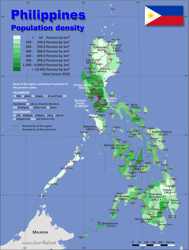
Philippines map - Click the map to get map as PDF file.
Other language versions are easy to generate, the descriptions are in own layers
Conditions for thematic maps with your own data and logotype
Delivery as printable file by e-mail or plot by post office
|
|---|
| Layers | |
| Provinces: | yes |
| Streets: | yes |
| Infrastructure: | yes |
| Rivers: | yes |
|
| Size | Till A2 |
| Delivery time | 7 working days | | Price |
| 1 bis 3 | 65 € | | > 3 | On request |
|
 |
All information published herein is free usable quoting the source,
including the maps, if they are not modified
|
|---|
Statistical data - Population density according to the administrative structure
The population data of the table below is census data from 2024, last available data.
Click on the column header brings the table in order of the column header.
The default order is the region name.
| Region |
ISO
3166-2 |
Capital |
Area
(km²) |
Population |
Density
(pers/km²) |
| Total |
|
|
|
321 306,00 |
112 727 776 |
|---|
| Last update: 11/30/2025 - 10:50:56 |
|---|
| Bangsamoro - Autonomous Region in Muslim Mindanao |
PH-14 |
Mindanao |
Cotabato City |
13 292,00 |
5 691 583 |
| Bicol Region (Region V) |
PH-05 |
Luzon |
Legazpi City |
18 155,80 |
6 064 426 |
| Cagayan Valley (Region II) |
PH-02 |
Luzon |
Tuguegarao City |
28 228,80 |
3 777 608 |
| CALABARZON (Region IV-A) |
PH-40 |
Luzon |
Calamba City |
16 873,30 |
16 933 234 |
| Caraga Region (Region XIII) |
PH-13 |
Mindanao |
Butuan |
21 478,40 |
2 865 196 |
| Central Luzon (Region III) |
PH-03 |
Luzon |
San Fernando City |
22 014,60 |
12 989 074 |
| Central Visayas (Region VII) |
PH-07 |
Visayas |
Cebu City |
10 163,00 |
6 640 875 |
| Cordillera Administrative Region (CAR) |
PH-15 |
Luzon |
Baguio City |
19 422,00 |
1 808 985 |
| Davao Region (Region XI) |
PH-11 |
Mindanao |
Davao City |
20 357,40 |
5 389 422 |
| Eastern Visayas (Region VIII) |
PH-08 |
Visayas |
Tacloban |
23 251,10 |
4 625 929 |
| Ilocos Region (Region I) |
PH-01 |
Luzon |
San Fernando City |
13 012,60 |
5 342 453 |
| MIMAROPA (Region IV-B) |
PH-41 |
Luzon |
Calapan City |
29 620,90 |
3 245 446 |
| National Capital Region (NCR) |
PH-00 |
Luzon |
Manila |
613,9 |
14 001 751 |
| Negros Island (NI) |
n.d. |
Negros |
Bacolod / Dumagueteá |
13 688,20 |
4 904 944 |
| Northern Mindanao (Region X) |
PH-10 |
Mindanao |
Cagayan de Oro |
20 496,00 |
5 178 326 |
| SOCCSKSARGEN (Region XII) |
PH-12 |
Mindanao |
Koronadal City |
22 337,30 |
4 462 776 |
| Western Visayas (Region VI) |
PH-06 |
Visayas |
Iloilo City |
12 829,00 |
4 861 911 |
| Zamboanga Peninsula (Region IX) |
PH-09 |
Mindanao |
Pagadian City |
15 471,70 |
3 943 837 |
In the following table, the regions are divided into provinces.
| Province |
HASC |
Region |
Capital
| Area
(km²) |
Population |
Density
(pers/km²) |
| Total |
|
|
|
321 306,00 |
112 727 776 |
350,8 |
|---|
| Last update: 11/30/2025 - 10:50:56 |
|---|
| Abra |
PH-ABR |
CAR |
Bangued |
4 165,30 |
246 948 |
59,3 |
| Agusan del Norteá(City of Butuan) |
PH-AGN |
XIII |
Cabadbaran |
3 546,90 |
789 630 |
222,6 |
| Agusan del Sur |
PH-AGS |
XIII |
Prosperidad |
9 989,50 |
740 531 |
74,1 |
| Aklan |
PH-AKL |
VI |
Kalibo |
1 821,40 |
634 422 |
348,3 |
| Albay |
PH-ALB |
V |
Legazpi |
2 575,80 |
1 379 398 |
535,5 |
| Antique |
PH-ANT |
VI |
San Jose |
2 729,20 |
643 173 |
235,7 |
| Apayao |
PH-APA |
CAR |
Kabugao |
4 413,40 |
126 587 |
28,7 |
| Aurora |
PH-AUR |
III |
Baler |
3 147,30 |
240 824 |
76,5 |
| Basilan |
PH-BAS |
ARMM |
Lamitan |
1 327,20 |
541 947 |
408,3 |
| Bataan |
PH-BAN |
III |
Balanga |
1 373,00 |
891 440 |
649,3 |
| Batanes |
PH-BTN |
II |
Basco |
219 |
18 937 |
86,5 |
| Batangas |
PH-BTG |
IV-A |
Batangas City |
3 119,70 |
2 994 795 |
960 |
| Benguetá(Baguio City) |
PH-BEN |
CAR |
La Trinidad |
2 826,60 |
841 616 |
297,7 |
| Biliran |
PH-BIL |
VIII |
Naval |
536 |
184 095 |
343,5 |
| Bohol |
PH-BOH |
VII |
Tagbilaran |
4 821,00 |
1 412 726 |
293 |
| Bukidnon |
PH-BUK |
X |
Malaybalay |
10 498,60 |
1 601 902 |
152,6 |
| Bulacan |
PH-BUL |
III |
Malolos |
2 796,10 |
3 876 806 |
1 386,50 |
| Cagayan |
PH-CAG |
II |
Tuguegarao |
9 295,80 |
1 284 676 |
138,2 |
| Camarines Norte |
PH-CAN |
V |
Daet |
2 320,10 |
604 666 |
260,6 |
| Camarines Sur |
PH-CAS |
V |
Pili |
5 497,00 |
2 063 314 |
375,4 |
| Camiguin |
PH-CAM |
X |
Mambajao |
238 |
94 892 |
398,8 |
| Capiz |
PH-CAP |
VI |
Roxas |
2 594,60 |
835 098 |
321,9 |
| Catanduanes |
PH-CAT |
V |
Virac |
1 492,20 |
261 169 |
175 |
| Cavite |
PH-CAV |
IV-A |
Imus City |
1 574,20 |
4 573 884 |
2 905,60 |
| Cebuá(City of Cebu, City of Lapu-Lapu, City of Man |
PH-CEB |
VII |
Cebu City |
5 342,00 |
5 228 149 |
978,7 |
| City of Isabela |
- |
IX |
City of Isabela |
219,9 |
151 297 |
688 |
| Cotabatoá(North Cotabato) |
PH-NCO |
XII |
Kidapawan |
9 008,90 |
1 286 142 |
142,8 |
| Davao de Oroá(Compostela Valley) |
PH-COM |
XI |
Nabunturan |
4 479,80 |
783 775 |
175 |
| Davao del Norte |
PH-DAV |
XI |
Tagum |
3 427,00 |
1 143 931 |
333,8 |
| Davao del Surá(City of Davao) |
PH-DAS |
XI |
Digos |
4 607,60 |
2 554 076 |
554,3 |
| Davao Occidental |
PH-DVO |
XI |
Malita |
2 163,50 |
317 598 |
146,8 |
| Davao Oriental |
PH-DAO |
XI |
Mati |
5 679,60 |
590 042 |
103,9 |
| Dinagat Islands |
PH-DIN |
XIII |
San Jose |
1 036,30 |
120 533 |
116,3 |
| Eastern Samar |
PH-EAS |
VIII |
Borongan |
4 660,50 |
472 683 |
101,4 |
| Guimaras |
PH-GUI |
VI |
Jordan |
604,6 |
192 874 |
319 |
| Ifugao |
PH-IFU |
CAR |
Lagawe |
2 628,20 |
208 668 |
79,4 |
| Ilocos Norte |
PH-ILN |
I |
Laoag |
3 467,90 |
618 850 |
178,5 |
| Ilocos Sur |
PH-ILS |
I |
Vigan |
2 596,00 |
709 991 |
273,5 |
| Iloiloá(City of Iloilo) |
PH-ILI |
VI |
Iloilo City |
5 079,20 |
2 556 344 |
503,3 |
| Isabela |
PH-ISA |
II |
Ilagan |
12 414,90 |
1 733 048 |
139,6 |
| Kalinga |
PH-KAL |
CAR |
Tabuk |
3 231,30 |
235 391 |
72,8 |
| La Union |
PH-LUN |
I |
San Fernando |
1 497,70 |
825 072 |
550,9 |
| Laguna |
PH-LAG |
IV-A |
Santa Cruz |
1 917,90 |
3 687 345 |
1 922,60 |
| Lanao del Norteá(City of Iligan) |
PH-LAN |
X |
Tubod |
4 159,90 |
1 129 857 |
271,6 |
| Lanao del Sur |
PH-LAS |
ARMM |
Marawi |
3 741,00 |
1 368 137 |
365,7 |
| Leyteá(inc City of Tacloban) |
PH-LEY |
VIII |
Tacloban |
6 515,10 |
2 082 811 |
319,7 |
| Maguindanao del Norteá(Cotabato City) |
PH-MAG |
ARMM |
Datu Odin Sinsuat |
2 551,00 |
1 124 811 |
440,9 |
| Maguindanao del Sur |
|
ARMM |
Buluan |
2 460,00 |
813 243 |
330,6 |
| Marinduque |
PH-MAD |
IV-B |
Boac |
952,6 |
226 522 |
237,8 |
| Masbate |
PH-MAS |
V |
Masbate City |
4 151,80 |
910 813 |
219,4 |
| Misamis Occidental |
PH-MSC |
X |
Oroquieta |
2 055,20 |
621 993 |
302,6 |
| Misamis Orientalá(City of Cagayan de Oro) |
PH-MSR |
X |
Cagayan de Oro |
3 544,30 |
1 729 682 |
488 |
| Mountain Province |
PH-MOU |
CAR |
Bontoc |
2 157,40 |
149 775 |
69,4 |
| N C R , 1st Districtá(Capital District, Manila) |
PH-NCR1 |
NCR |
Manila |
42,9 |
1 902 590 |
44 370,10 |
| N C R , 2nd Districtá(Eastern Manila District) |
PH-NCR2 |
NCR |
Quezon |
236,4 |
5 008 857 |
21 191,60 |
| N C R , 3rd Districtá(CAMANAVA District) |
PH-NCR3 |
NCR |
Caloocan |
126,4 |
3 080 925 |
24 370,60 |
| N C R , 4th Districtá(Southern Manila District) |
PH-NCR4 |
NCR |
Tagaytay |
208,3 |
4 009 379 |
19 249,90 |
| Negros Occidentalá(City of Bacolod) |
PH-NEC |
NI |
Bacolod |
7 965,20 |
3 305 264 |
415 |
| Negros Oriental |
PH-NER |
NI |
Dumaguete |
5 385,50 |
1 492 038 |
277 |
| Northern Samar |
PH-NSA |
VIII |
Catarman |
3 692,90 |
645 789 |
174,9 |
| Nueva Ecija |
PH-NUE |
III |
Palayan |
5 751,30 |
2 395 816 |
416,6 |
| Nueva Vizcaya |
PH-NUV |
II |
Bayombong |
3 975,70 |
530 106 |
133,3 |
| Occidental Mindoro |
PH-MDC |
IV-B |
Mamburao |
5 865,70 |
511 417 |
87,2 |
| Oriental Mindoro |
PH-MDR |
IV-B |
Calapan |
4 238,40 |
919 504 |
216,9 |
| Palawaná(City of Puerto Princesa) |
PH-PLW |
IV-B |
Puerto Princesa |
17 030,80 |
1 285 179 |
75,5 |
| Pampangaá(City of Angeles) |
PH-PAM |
III |
San Fernando |
2 062,50 |
3 069 898 |
1 488,50 |
| Pangasinan |
PH-PAN |
I |
Lingayen |
5 451,00 |
3 188 540 |
584,9 |
| Quezoná(City of Lucena) |
PH-QUE |
IV-A |
Lucena |
9 069,60 |
2 260 669 |
249,3 |
| Quirino |
PH-QUI |
II |
Cabarroguis |
2 323,50 |
210 841 |
90,7 |
| Rizal |
PH-RIZ |
IV-A |
Antipolo |
1 191,90 |
3 416 541 |
2 866,40 |
| Romblon |
PH-ROM |
IV-B |
Romblon |
1 533,50 |
302 824 |
197,5 |
| Samará(Western Samar) |
PH-WSA |
VIII |
Catbalogan |
6 048,00 |
806 179 |
133,3 |
| Sarangani |
PH-SAR |
XII |
Alabel |
3 601,30 |
580 915 |
161,3 |
| Siquijor |
PH-SIG |
NI |
Siquijor |
337,5 |
107 642 |
318,9 |
| Sorsogon |
PH-SOR |
V |
Sorsogon City |
2 119,00 |
845 066 |
398,8 |
| South Cotabatoá(City of General Santos) |
PH-SCO |
XII |
Koronadal |
4 428,80 |
1 732 068 |
391,1 |
| Southern Leyte |
PH-SLE |
VIII |
Maasin |
1 798,60 |
434 372 |
241,5 |
| Special Geographic Areaá(Interim Province) |
- |
ARMM |
- |
542,8 |
214 703 |
395,5 |
| Sultan Kudarat |
PH-SUK |
XII |
Isulan |
5 298,30 |
863 651 |
163 |
| Sulu |
PH-SLU |
ARMM |
Jolo / Patikul |
1 516,00 |
1 146 097 |
756 |
| Surigao del Norte |
PH-SUN |
XIII |
Surigao City |
1 972,90 |
565 644 |
286,7 |
| Surigao del Sur |
PH-SUR |
XIII |
Tandag |
4 932,70 |
648 858 |
131,5 |
| Tarlac |
PH-TAR |
III |
Tarlac City |
3 053,60 |
1 568 162 |
513,5 |
| Tawi-Tawi |
PH-TAW |
ARMM |
Bongao |
1 154,00 |
482 645 |
418,2 |
| Zambalesá(City of Olongapo) |
PH-ZMB |
III |
Iba |
3 830,80 |
946 128 |
247 |
| Zamboanga del Norte |
PH-ZAN |
IX |
Dipolog |
6 284,00 |
1 067 067 |
169,8 |
| Zamboanga del Surá(City of Zamboanga) |
PH-ZAS |
IX |
Pagadian |
5 360,00 |
2 063 975 |
385,1 |
| Zamboanga Sibugay |
PH-ZSI |
IX |
Ipil |
3 607,80 |
661 498 |
183,4 |
Existing thematic maps
|
External links change quickly - If you get a link error - Please inform us!
 |
Membership in international organisations and treaties
Expand list
Political Alliances
Regional Unions
Military alliances/Arms control
Law enforcement
Business Alliances
Fishery
Financial
Free Trade Area, Internal Market
Technical alliances
Environment
Transport
Cientific
Humanitarian Unions
Cultural Unions
|
|
If you have suggestions to include other information or you find missed links, please inform us!
Click here ... |
International Border disputes
Expand list
See also neighboring states
|
| |


