Territory of Guam
| Capital |
Currency | Government system |
|---|
| Hagntna |
US-Dollar (USD) |
Dependent from USA |
| Official language | Region |
Population |
|---|
English
Chamorro
Carolinian |
Far East |
2020 - 168 775 |
Country map - Administrative structure - Population density of Guam
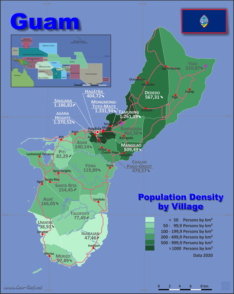
Guam map - Click the map to get map as PDF file.
Other language versions are easy to generate, the descriptions are in own layers
Conditions for thematic maps with your own data and logotype
Delivery as printable file by e-mail or plot by post office
|
|---|
| Layers | |
| Provinces: | yes |
| Streets: | yes |
| Infrastructure: | yes |
| Rivers: | yes |
|
| Size | Till A2 |
| Delivery time | 7 working days | | Price |
| 1 bis 3 | 60 € | | > 3 | On request |
|
 |
All information published herein is free usable quoting the source,
including the maps, if they are not modified
|
|---|
Statistical data - Population density according to the administrative structure
The population data of the table below is census data from 2020, last available data.
The ISO files are contradictory - the data given were only named by a secondary source.
Click on the column header brings the table in order of the column header.
The default order is the village name.
| Village |
ISO
3166-2 |
region |
Capital |
Area
(km²) |
Population |
Density
(pers/km²) |
| Total |
|
|
|
543,54 |
153 836 |
283,03 |
|---|
| Last update: 01/16/2024 - 22:32:45 |
|---|
| Agana Heights |
GU-AHT |
Central |
Agana Heights |
2,68 |
3 673 |
1 370,52 |
| Agat |
GU-AGT |
South |
Agat |
27,19 |
4 515 |
166,05 |
| Asan-Maina |
GU-ASN |
Central |
Asan-Maina |
14,35 |
2 011 |
140,14 |
| Barrigada |
GU-BGD |
Central |
Barrigada |
21,96 |
7 956 |
362,30 |
| Chalan-Pago-Ordot |
GU-CPO |
Central |
Chalan-Pago-Ordot |
14,73 |
7 064 |
479,57 |
| Dededo |
GU-DDD |
North |
Dededo |
79,16 |
44 908 |
567,31 |
| Hagåtña |
GU-HAG |
Central |
Hagåtña |
2,33 |
943 |
404,72 |
| Inarajan |
GU-IRJ |
South |
Inarajan |
48,82 |
2 317 |
47,46 |
| Mangilao |
GU-MGL |
Central |
Mangilao |
26,45 |
13 476 |
509,49 |
| Merizo |
GU-MRZ |
South |
Merizo |
16,39 |
1 604 |
97,86 |
| Mongmong-Toto-Maite |
GU-MTM |
Central |
Mongmong-Toto-Maite |
4,79 |
6 380 |
1 331,94 |
| Piti |
GU-PTI |
Central |
Piti |
19,26 |
1 585 |
82,29 |
| Santa Rita |
GU-SRT |
South |
Santa Rita |
41,89 |
6 470 |
154,45 |
| Sinajana |
GU-SJN |
Central |
Sinajana |
2,20 |
2 611 |
1 186,82 |
| Talofofo |
GU-TLF |
South |
Talofofo |
45,81 |
3 550 |
77,49 |
| Tamuning (including Tumon) |
GU-TMN |
North |
Tamuning |
14,66 |
18 489 |
1 261,19 |
| Umatac |
GU-UMT |
South |
Umatac |
16,63 |
647 |
38,91 |
| Yigo |
GU-YGO |
North |
Yigo |
91,71 |
19 339 |
210,87 |
| Yona |
GU-YNA |
South |
Yona |
52,53 |
6 298 |
119,89 |
Existing thematic maps
|
External links change quickly - If you get a link error - Please inform us!
 |
Membership in international organisations and treaties
Expand list
Regional Unions
Technical alliances
Environment
Cultural Unions
|
|
If you have suggestions to include other information or you find missed links, please inform us!
Click here ... |
See also neighboring states
|


