Malaysia
| Capital |
Currency | Government system |
|---|
| Kuala Lumpur |
Ringgit (MYR) |
Constitutional monarchy |
| Official language | Region |
Population |
|---|
| Malay |
Far East |
Census 2023
32 447 385 |
Country map - Administrative structure - Population density of Malaysia
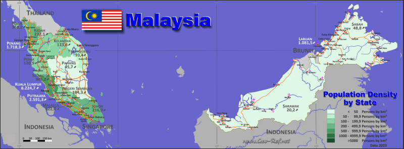
Malaysia map - Click the map to get map as PDF file.
Other language versions are easy to generate, the descriptions are in own layers
Conditions for thematic maps with your own data and logotype
Delivery as printable file by e-mail or plot by post office
|
|---|
| Layers | |
| Provinces: | yes |
| Streets: | yes |
| Infrastructure: | yes |
| Rivers: | yes |
|
| Size | Till A2 |
| Delivery time | 7 working days | | Price |
| 1 bis 3 | 75 € | | > 3 | On request |
|
 |
All information published herein is free usable quoting the source,
including the maps, if they are not modified
|
|---|
Statistical data - Population density according to the administrative structure
The population data of the table below is census data from 2023, last available data.
Click on the column header brings the table in order of the column header.
The default order is the territory name.
| Territory |
ISO
3166-2 |
Type |
Capital |
Area
(km²) |
Population |
Density
(pers/km²) |
| Total |
|
|
|
329 893 |
32 447 385 |
98,4 |
|---|
| Last update: 01.10.2024 - 02:24:05 |
|---|
| Johor |
MY-01 |
State |
Johor Bahru |
18 987 |
4 009 670 |
211,2 |
| Kedah |
MY-02 |
State |
Alor Setar |
9 425 |
2 131 427 |
226,1 |
| Kelantan |
MY-03 |
State |
Kota Bahru |
15 024 |
1 792 501 |
119,3 |
| Kuala Lumpur |
MY-14 |
Federal territory |
Kuala Lumpur |
243 |
1 982 112 |
8 156,8 |
| Labuan |
MY-15 |
Federal territory |
Kuala Lumpur |
92 |
95 120 |
1 033,9 |
| Malacca |
MY-04 |
State |
Malacca |
1 652 |
998 428 |
604,4 |
| Negeri Sembilan |
MY-05 |
State |
Seremban |
6 644 |
1 199 974 |
180,6 |
| Pahang |
MY-07 |
State |
Kuantan |
35 965 |
1 591 295 |
44,2 |
| Penang |
MY-06 |
State |
George Town |
1 031 |
1 740 405 |
1 688,1 |
| Perak |
MY-08 |
State |
Ipoh |
21 005 |
2 496 041 |
118,8 |
| Perlis |
MY-09 |
State |
Kangar |
795 |
284 885 |
358,3 |
| Putrajaya |
MY-16 |
Federal territory |
Kuala Lumpur |
46 |
109 202 |
2 374,0 |
| Sabah |
MY-12 |
State |
Kota Kinabalu |
73 619 |
3 418 785 |
46,4 |
| Sarawak |
MY-13 |
State |
Kuching |
124 450 |
2 453 677 |
19,7 |
| Selangor |
MY-10 |
State |
Shah Alam |
7 960 |
6 994 423 |
878,7 |
| Terengganu |
MY-11 |
State |
Kuala Terengganu |
12 955 |
1 149 440 |
88,7 |
Existing thematic maps
|
External links change quickly - If you get a link error - Please inform us!
 |
Membership in international organisations and treaties
Expand list
Political Alliances
Regional Unions
Military alliances/Arms control
Law enforcement
Business Alliances
Fishery
Financial
Free Trade Area, Internal Market
Technical alliances
Transport
Cientific
Humanitarian Unions
Cultural Unions
|
|
If you have suggestions to include other information or you find missed links, please inform us!
Click here ... |
International Border disputes
Expand list
Land boundaries
Maritime boundaries
See also neighboring states
|
| |


