Paracel Islands
Capital |
Currency | Government system |
Yongxing Dao |
Renminbi (CNY) |
Dependent from China |
Official language | Region |
Population |
Standard Mandarin Cantonese Portuguese English |
Far East |
No data |
Country map - Administrative structure - Population density of Paracel Islands
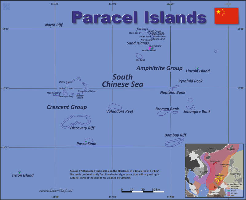
Paracel Islands map - Click the map to get map as PDF file.
Other language versions are easy to generate, the descriptions are in own layers
Conditions for thematic maps with your own data and logotype Delivery as printable file by e-mail or plot by post office |
Layers | |
Provinces: | yes |
Streets: | no |
Infrastructure: | yes |
Rivers: | yes |
|
Size | Till A2 |
Delivery time | 7 working days | Price |
1 bis 3 | 60 € | > 3 | On request |
|
 |
All information published herein is free usable quoting the source, including the maps, if they are not modified
|
Actual situation of the area
The Paracel Islands are a conglomeration of natural islands, reefs and
artificial islands built on top of natural reefs. The ownership situation
between the neighbouring countries is controversial, since the zones of economic
use and historical claims are overlapping. The more detailed table ilustrates
the situation.
The table below summarizes the consolidated information and geographically
reviewed situation of the islands and reefs. Different sources were included,
which, given the different interests of the neighboring countries, resulted in
conflicting information that was at least reconciled geographically. Where this
could not be done sufficiently, this is noted in the table. The sources used are
noted below the table.
The reefs have been included as they are considered starting points for
declaration of territorial claims and are generally used as the basis for
artificial islands.
From the controversial assignment - see table - it must be stated seen as
incomplete information - the assignment is also controversial. If you note any
errors or you have additional information, please let us know by email.
CH |
China |
TW |
Taiwan |
VN |
Vietnam |
o |
Controled |
|
|
x |
Claimed |
English |
Island group |
Coordinates |
Area in km² |
Observation |
CH |
TW |
VN |
Last update: 02/21/2022 - 21:14:01 |
All Wealth |
Crescent |
16°34'29"N 111°40'24"E |
0,02 |
Sand dunes |
o |
x |
x |
Antelope Reef |
Crescent |
16°27'44"N 111°35'20"E |
0,00 |
In the southeast corner there is a small sand
dune. |
o |
x |
x |
Bombay Reef |
- |
16°02'41"N 112°31'06"E |
0,00 |
Open atoll |
o |
x |
x |
Bremen Bank |
Eastern |
16°20'00"N 112°25'40"E |
0,00 |
Bank |
o |
x |
x |
Dido Bank |
- |
16°49'00"N 112°53'00"E |
0,00 |
Bank |
o |
x |
x |
Discovery Reef |
- |
16°13'52"N 111°41'35"E |
0,00 |
Open atoll |
o |
x |
x |
Drummond Island |
Crescent |
16°27'50"N 111°44'30"E |
0,21 |
Atoll |
o |
x |
x |
Duncan Island |
Crescent |
16°27'05"N 111°42'45"E |
0,48 |
Atoll |
o |
x |
x |
Herald Bank |
- |
15°43'00"N 112°13'00"E |
0,00 |
Bank, Verification need |
o |
x |
x |
Iltis Bank |
- |
16°46'00"N 112°13'00"E |
0,00 |
|
o |
x |
x |
Jehangire Reefs/Bank |
Eastern |
16°26'59"N 112°35'41"E |
0,00 |
Reef/reef cluster |
o |
x |
x |
Lincoln Island |
Eastern |
16°40'00"N 112°44'00"E |
1,60 |
Atoll |
o |
x |
x |
Middle Island |
Seven Sisters |
16°57'18"N 112°19'28"E |
0,13 |
Atoll |
o |
x |
x |
Middle Sand |
Seven Sisters |
16°56'03"N 112°20'37"E |
0,05 |
Dune |
o |
x |
x |
Money Island |
Crescent |
16°26'50"N 111°30'20"E |
0,36 |
Atoll |
o |
x |
x |
Neptuna Bank |
Eastern |
16°30'54"N 112°32'13"E |
0,00 |
Bank |
o |
x |
x |
North Island |
Seven Sisters |
16°57'50"N 112°18'34"E |
0,04 |
Atoll |
o |
x |
x |
North Reef |
- |
17°05'25"N 111°30'13"E |
0,00 |
Open atoll |
o |
x |
x |
North Sand |
Seven Sisters |
16°56'16"N 112°20'30"E |
0,02 |
Dune |
o |
x |
x |
Observation Bank (Silver Islet) |
Crescent |
16°34'50"N 111°42'30"E |
0,01 |
Coral reef, with a small sand dune |
o |
x |
x |
Palm Island |
Crescent |
16°27'08"N 111°42'03"E |
0,06 |
Atoll, Westrn part of Duncan Island |
o |
x |
x |
Passu Keah |
- |
16°03'23"N 111°45'43"E |
0,40 |
Sand dunes only occupy a very small area compared to the
entire atoll (ring reef) |
o |
x |
x |
Pattle Island |
Crescent |
16°32'05"N 111°36'30"E |
0,31 |
Atoll |
o |
x |
x |
Pyramid Rock |
Eastern |
16°34'37"N 112°38'33"E |
0,04 |
Floating stone |
o |
x |
x |
Robert Island (Round Island) |
Crescent |
16°30'20"N 111°35'10"E |
0,30 |
Atoll |
o |
x |
x |
Rocky Island |
Amphitrite |
16°50'18"N 112°20'38"E |
0,08 |
Rocky island |
o |
x |
x |
South Island |
Seven Sisters |
16°56'47"N 112°20'4"E |
0,17 |
Atoll |
o |
x |
x |
South Sand |
Seven Sisters |
16°55'45"N 112°20'45"E |
0,06 |
Dune |
o |
x |
x |
Tree Island |
Amphitrite |
16°58'47"N 112°16'16"E |
0,22 |
Atoll |
x |
x |
o |
Triton Island |
- |
15°47'00"N 111°12'00"E |
1,20 |
Dune |
o |
x |
x |
Vuladdore Reef |
Crescent |
16°20'50"N 112°01'30"E |
0,00 |
Open atoll |
o |
x |
x |
West Sand |
Amphitrite |
16°58'39"N 112°12'43"E |
0,04 |
Dune |
o |
x |
x |
Woody Island |
Amphitrite |
16°50'00"N 112°20'00"E |
2,10 |
Atoll |
o |
x |
x |
Yagong Island / He Duck |
Crescent |
16°34'00"N 111°41'11"E |
0,01 |
Dune |
o |
x |
x |
Other new registered islands an reefs
English |
Island group |
Coordinates |
Area in km² |
Observation |
CH |
TW |
VN |
Last update: 02/21/2022 - 21:14:01 |
Reefs placed by Vietnam
|
Salty Hut |
Crescent |
16°32'48"N 111°42'48"E |
0,00 |
The reef, located southwest between the canal connecting The
Conch Beach and Crescent Reef, is the part that extends into the center
of the Conch-Crescent reef, belonging to the Crescent group |
|
|
|
Stone Islet |
Crescent |
16°30'30"N 111°46'12"E |
0,00 |
The reef, which has Duy Dream Island and a blue hole discovered in
2016, belongs to the Crescent group. |
|
|
|
Unknown |
|
16°32'00"N 111°36'00"E |
0,00 |
The reef, which is located on Paracel Island, belongs to the
Crescent group |
|
|
|
Unknown |
- |
16°27'11"N 111°39'25"E |
0,00 |
The reef is located between Hai Sam rock and Quang Hoa Island,
belonging to the Crescent group |
|
|
|
Unknown |
- |
16°34'31"N 111°39'59"E |
0,00 |
The reef, which has Snail Island and Ba Ba Island, belongs to the
Crescent group |
|
|
|
Unknown |
- |
16°58'36"N 112°15'24"E |
0,00 |
Coral reef, on the island of Trees and West Dunes, belonging to An
Vinh group |
|
|
|
Islands and Reefs placed by China
|
Lesser Silver Islet |
Crescent |
16°35'00"N 111°42'00"E |
0,00 |
Dune |
|
|
|
Little Basket |
Crescent |
16°27'00"N 111°38'00"E |
0,01 |
Dune Verification need |
|
|
|
New West Sand |
Seven Sisters |
16°55'00"N 112°21'00"E |
0,00 |
Dune Verification need |
|
|
|
South of South Sand |
Seven Sisters |
16°55'00"N 112°21'00"E |
0,00 |
Dune Verification need |
|
|
|
Unknown |
- |
16°33'00"N 111°43'00"E |
0,00 |
|
|
|
|
Used sources:
- http://southchinasea.org/macand/gazetteer.htm
- Wikipedia - diferent languge versions
- https://www.marineregions.org
- https://www.geographic.org/
- https://web.archive.org/web/20070717152713/http://www.southchinasea.org/macand/gazetteer.htm
Naming of the islands in the languages of the neighboring countries
Click on the column header brings the table in order of the column header. The
default order is the English name.
English |
Chinesisch |
Vietnamesisch |
CH |
TW |
VN |
Last update: 02/21/2022 - 21:14:01 |
All Wealth |
Quanfu Dao |
Đảo Ốc Hoa |
o |
x |
x |
Antelope Reef |
Lingyang Jiao |
Đá Hải Sâm |
o |
x |
x |
Bombay Reef |
Langhua Jiao |
Đá Bông Bay |
o |
x |
x |
Bremen Bank |
Binmei Tan |
Bãi Châu Nhai |
o |
x |
x |
Dido Bank |
Xidu Tan |
Bãi Gò Nổi |
o |
x |
x |
Discovery Reef |
Huaguang Jiao |
Đá Lồi |
o |
x |
x |
Drummond Island |
Jinqing Dao |
Đảo Duy Mộng |
o |
x |
x |
Duncan Island |
Chenhang Dao |
Đảo Quang Hoà |
o |
x |
x |
Herald Bank |
Songtao Tan |
Bãi Ốc Tai Voi |
o |
x |
x |
Iltis Bank |
in Shuo Tan |
Bãi Bình Sơn |
o |
x |
x |
Jehangire Reefs/Bank |
Zhanhan Tan |
Bãi Quảng Nghĩa |
o |
x |
x |
Lincoln Island |
Dong Dao |
Đảo Linh Côn |
o |
x |
x |
Middle Island |
Zhong Dao |
Đảo Trung |
o |
x |
x |
Middle Sand |
Zhong Shazhou |
Cồn cát Trung |
o |
x |
x |
Money Island |
Jinyin Dao |
Đảo Quang Ảnh |
o |
x |
x |
Neptuna Bank |
Beibian Lang |
Bãi Thủy Tề |
o |
x |
x |
North Island |
Bei Dao |
Đảo Bắc |
o |
x |
x |
North Reef |
Bei Jiao |
Đá Bắc |
o |
x |
x |
North Sand |
Bei Shazhou |
Cồn cát Bắc |
o |
x |
x |
Observation Bank (Silver Islet) |
Yin Yu |
Bãi Xà Cừ |
o |
x |
x |
Palm Island |
Guangjin Dao |
Đảo Quang Hoà Tây |
o |
x |
x |
Passu Keah |
Panshi Yu |
Đảo Bạch Quy |
o |
x |
x |
Pattle Island |
Shanhu Dao |
Đảo Hoàng Sa |
o |
x |
x |
Pyramid Rock |
Gaojian Shi |
Hòn Tháp |
o |
x |
x |
Robert Island (Round Island) |
Ganquan Dao |
Đảo Hữu Nhật |
o |
x |
x |
Rocky Island |
Shidao |
Đảo Đá |
o |
x |
x |
South Island |
Nan Dao |
Đảo Nam |
o |
x |
x |
South Sand |
Nan Shazhou |
Cồn cát Nam |
o |
x |
x |
Tree Island |
Zhaoshudao |
Đảo Cây |
x |
x |
o |
Triton Island |
Zhongjian Dao |
Đảo Tri Tôn |
o |
x |
x |
Vuladdore Reef |
Yuduo Jiao |
Đá Chim Én |
o |
x |
x |
West Sand |
Xisha Zhou |
Cồn cát Tây |
o |
x |
x |
Woody Island |
Yongxing Dao |
Đảo Phú Lâm |
o |
x |
x |
Yagong Island (He Duck) |
Yagong Dao |
Đảo Ba Ba |
o |
x |
x |
Other new registered islands an reefs
English |
Chinesisch |
Vietnamesisch |
CH |
TW |
VN |
Last update: 02/21/2022 - 21:14:01 |
New reefs placed by Vietnam |
Stone Islet |
Shi Yu |
Đảo Lưỡi Liềm |
|
|
|
Unknown |
Unknown |
Bãi Đèn Pha |
|
|
|
Unknown |
Unknown |
Bãi Ngự Bình |
|
|
|
Unknown |
Unknown |
Đá Sơn Kỳ |
|
|
|
Salty Hut |
Xianshe Yu |
Đá Trà Tây |
|
|
|
New reefs placed by China |
Lesser Silver Islet |
Yinyu Zi |
Unknown |
|
|
|
Unknown |
Xiánshě Yu |
Unknown |
|
|
|
Little Basket |
Kuangzai Shazhou |
Unknown |
|
|
|
South of South Sand |
Dongxin Shazhou |
Unknown |
|
|
|
New West Sand |
Xixin Shazhou |
Unknown |
|
|
|
Existing thematic maps
|
News Covid-19
Numbers from MS Bing
External links change quickly - If you get a link error - Please inform us!
|
See also neighboring states
|