United Republic of Tanzania
| Capital |
Currency | Government system |
|---|
| Dodoma |
Tanzanian Shilling (TZS) |
Presidential system |
| Official language | Region |
Population |
|---|
| Swahili |
Africa |
Census 2022
61 741 120 |
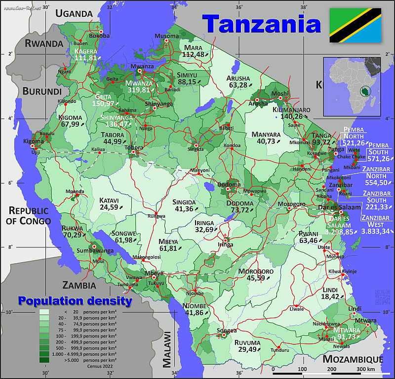
Country map - Administrative structure - Population density of Tanzania
Tanzania map - Click the map to get map as PDF file.
Other language versions are easy to generate, the descriptions are in own layers
Conditions for thematic maps with your own data and logotype
Delivery as printable file by e-mail or plot by post office
|
|---|
| Layers | |
| Provinces: | yes |
| Streets: | yes |
| Infrastructure: | yes |
| Rivers: | yes |
|
| Size | Till A2 |
| Delivery time | 7 working days | | Price |
| 1 bis 3 | 75 € | | > 3 | On request |
|
 |
All information published herein is free usable quoting the source,
including the maps, if they are not modified
|
|---|
Statistical data - Population density according to the administrative structure
The population data of the table below is census data from 2022, last available data.
Click on the column header brings the table in order of the column header.
The default order is the region name.
| Region |
ISO
3166-2 |
Capital |
Area
(km²) |
Population |
Density
(pers/km²) |
| Total |
|
|
884 286 |
61 741 120 |
69,82 |
|---|
| Last update: 01.06.2025 - 19:53:35 |
|---|
| Arusha |
TZ-01 |
Arusha |
36 921 |
2 356 255 |
63,82 |
| Dar es Salaam |
TZ-02 |
Dar es Salaam |
1 632 |
5 383 728 |
3 298,85 |
| Dodoma |
TZ-03 |
Dodoma |
41 854 |
3 085 625 |
73,72 |
| Geita |
TZ-27 |
Geita |
19 723 |
2 977 608 |
150,97 |
| Iringa |
TZ-04 |
Iringa |
36 482 |
1 192 728 |
32,69 |
| Kagera |
TZ-05 |
Bukoba |
26 736 |
2 989 299 |
111,81 |
| Katavi |
TZ-28 |
Mpanda |
46 881 |
1 152 958 |
24,59 |
| Kigoma |
TZ-08 |
Kigoma |
36 343 |
2 470 967 |
67,99 |
| Kilimanjaro |
TZ-09 |
Moshi |
13 275 |
1 861 934 |
140,26 |
| Lindi |
TZ-12 |
Lindi |
64 838 |
1 194 028 |
18,42 |
| Manyara |
TZ-26 |
Babati |
46 461 |
1 892 502 |
40,73 |
| Mara |
TZ-13 |
Musoma |
21 089 |
2 372 015 |
112,48 |
| Mbeya |
TZ-14 |
Mbeya |
37 920 |
2 343 754 |
61,81 |
| Morogoro |
TZ-16 |
Morogoro |
70 125 |
3 197 104 |
45,59 |
| Mtwara |
TZ-17 |
Mtwara |
17 823 |
1 634 947 |
91,73 |
| Mwanza |
TZ-18 |
Mwanza |
11 569 |
3 699 872 |
319,81 |
| Njombe |
TZ-29 |
Njombe |
21 258 |
889 946 |
41,86 |
| Pemba North |
TZ-06 |
Wete |
526 |
272 091 |
517,28 |
| Pemba South |
TZ-10 |
Chake Chake |
475 |
271 350 |
571,26 |
| Pwani |
TZ-19 |
Kisiju |
31 907 |
2 024 947 |
63,46 |
| Rukwa |
TZ-20 |
Sumbawanga |
21 917 |
1 540 519 |
70,29 |
| Ruvuma |
TZ-21 |
Songea |
62 700 |
1 848 794 |
29,49 |
| Shinyanga |
TZ-22 |
Shinyanga |
16 423 |
2 241 299 |
136,47 |
| Simiyu |
TZ-30 |
Bariadi |
24 283 |
2 140 497 |
88,15 |
| Singida |
TZ-23 |
Singida |
48 554 |
2 008 058 |
41,36 |
| Songwe |
TZ-31 |
Vwawa |
21 696 |
1 344 687 |
61,98 |
| Tabora |
TZ-24 |
Tabora |
75 383 |
3 391 679 |
44,99 |
| Tanga |
TZ-25 |
Tanga |
27 910 |
2 615 597 |
93,72 |
| Zanzibar North |
TZ-07 |
Mkokotoni |
464 |
257 290 |
554,50 |
| Zanzibar South |
TZ-11 |
Koani |
885 |
195 873 |
221,33 |
| Zanzibar West |
TZ-15 |
Zanzibar |
233 |
893 169 |
3 833,34 |
The regions are subdivided into districts, and their data can be found in the following table.shown in the next table.
| District |
Own |
Region |
Capital
| Area
(km²) |
Population |
Density
(pers/km²) |
| Total |
|
|
|
884 286 |
61 741 120 |
69,8 |
|---|
| Last update: 01.06.2025 - 19:53:35 |
|---|
| Arusha City |
TZ-01-01 |
Arusha |
Arusha |
267 |
617 631 |
2 313,2 |
| Arusha Rural |
TZ-01-02 |
Arusha |
Arusha |
1 237 |
449 518 |
363,4 |
| Babati Rural |
TZ-26-01 |
Manyara |
Babati |
5 569 |
375 200 |
67,4 |
| Babati Town |
TZ-26-02 |
Manyara |
Babati |
471 |
129 572 |
275,1 |
| Bagamoyo |
TZ-19-01 |
Pwani |
Bagamoyo |
1 423 |
205 478 |
144,4 |
| Bahi |
TZ-03-01 |
Dodoma |
Bahi |
5 630 |
322 526 |
57,3 |
| Bariadi Rural |
TZ-30-01 |
Simiyu |
Bariadi |
4 737 |
383 385 |
80,9 |
| Bariadi Town |
TZ-30-02 |
Simiyu |
Bariadi |
747 |
260 927 |
349,3 |
| Biharamulo |
TZ-05-01 |
Kagera |
Biharamulo |
7 463 |
457 114 |
61,3 |
| Buchosa |
TZ-18-01 |
Mwanza |
Nyehunge |
1 311 |
413 110 |
315,1 |
| Buhigwe |
TZ-08-01 |
Kigoma |
Buhigwe |
1 506 |
240 005 |
159,4 |
| Bukoba Municipal |
TZ-05-02 |
Kagera |
Bukoba |
84 |
144 938 |
1 725,5 |
| Bukoba Rural |
TZ-05-03 |
Kagera |
Bukoba |
1 618 |
322 448 |
199,3 |
| Bukombe |
TZ-27-01 |
Geita |
Ushirombo |
8 055 |
407 102 |
50,5 |
| Bumbuli |
TZ-25-01 |
Tanga |
Bumbuli |
794 |
159 373 |
200,7 |
| Bunda Rural |
TZ-13-01 |
Mara |
Bunda |
2 078 |
243 822 |
117,3 |
| Bunda Town |
TZ-13-02 |
Mara |
Bunda |
1 015 |
182 970 |
180,3 |
| Busega |
TZ-30-03 |
Simiyu |
Nyashimo |
1 424 |
282 167 |
198,2 |
| Busekelo |
TZ-14-01 |
Mbeya |
Busokelo |
714 |
100 123 |
140,2 |
| Butiama |
TZ-13-03 |
Mara |
Butiama |
1 962 |
281 656 |
143,6 |
| Chake Chake |
TZ-10-01 |
Pemba South |
Chake Chake |
219 |
136 298 |
622,4 |
| Chalinze |
TZ-19-02 |
Pwani |
Chalinze |
7 032 |
316 759 |
45,0 |
| Chamwino |
TZ-03-02 |
Dodoma |
Chamwino |
9 123 |
486 176 |
53,3 |
| Chato |
TZ-27-02 |
Geita |
Chato |
3 074 |
584 963 |
190,3 |
| Chemba |
TZ-03-03 |
Dodoma |
Chemba |
7 289 |
339 333 |
46,6 |
| Chunya |
TZ-14-02 |
Mbeya |
Chunya |
17 505 |
344 471 |
19,7 |
| Dar es Salaam City |
TZ-02-01 |
Dar es Salaam |
Dar es Salaam |
365 |
1 649 912 |
4 520,3 |
| Dodoma City |
TZ-03-04 |
Dodoma |
Dodoma |
2 607 |
765 179 |
293,5 |
| Gairo |
TZ-16-01 |
Morogoro |
Gairo |
1 971 |
258 205 |
131,0 |
| Geita Rural |
TZ-27-03 |
Geita |
Kharumwa |
3 671 |
1 035 214 |
282,0 |
| Geita Town |
TZ-27-04 |
Geita |
Geita |
1 036 |
361 671 |
349,1 |
| Hai |
TZ-09-01 |
Kilimanjaro |
Bomang`ombe |
903 |
240 999 |
266,9 |
| Hanang |
TZ-26-03 |
Manyara |
Katesh |
3 674 |
367 391 |
100,0 |
| Handeni Rural |
TZ-25-02 |
Tanga |
Handeni |
6 529 |
384 353 |
58,9 |
| Handeni Town |
TZ-25-03 |
Tanga |
Handeni |
837 |
108 968 |
130,2 |
| Ifakara Town |
TZ-16-02 |
Morogoro |
Ifakara Town |
7 205 |
290 424 |
40,3 |
| Igunga |
TZ-24-01 |
Tabora |
Igunga |
7 064 |
546 204 |
77,3 |
| Ikungi |
TZ-23-01 |
Singida |
Ikungi |
8 860 |
411 262 |
46,4 |
| Ileje |
TZ-31-01 |
Songwe |
Ileje |
1 880 |
125 869 |
67,0 |
| Ilemela Municipal |
TZ-18-02 |
Mwanza |
Mwanza |
255 |
509 687 |
1 998,8 |
| Iramba |
TZ-23-02 |
Singida |
Kiomboi |
4 520 |
328 912 |
72,8 |
| Iringa Municipal |
TZ-04-01 |
Iringa |
Iringa |
369 |
202 490 |
548,8 |
| Iringa Rural |
TZ-04-02 |
Iringa |
Kalenga |
18 783 |
315 354 |
16,8 |
| Itigi |
TZ-23-03 |
Singida |
Itigi |
19 539 |
215 947 |
11,1 |
| Itilima |
TZ-30-04 |
Simiyu |
Itilima |
4 690 |
419 213 |
89,4 |
| Kahama Municipal |
TZ-22-01 |
Shinyanga |
Kahama |
1 363 |
453 654 |
332,8 |
| Kakonko |
TZ-08-02 |
Kigoma |
Kakonko |
2 209 |
178 419 |
80,8 |
| Kalambo |
TZ-20-01 |
Rukwa |
Matai |
5 569 |
316 783 |
56,9 |
| Kaliua |
TZ-24-02 |
Tabora |
Kaliua |
15 335 |
678 447 |
44,2 |
| Karagwe |
TZ-05-04 |
Kagera |
Kayanga |
5 433 |
385 744 |
71,0 |
| Karatu |
TZ-01-03 |
Arusha |
Karatu |
3 238 |
280 454 |
86,6 |
| Kaskazini A Municipal |
TZ-07-01 |
Zanzibar North |
Kaskazini |
230 |
157 369 |
684,2 |
| Kaskazini B Municipal |
TZ-07-02 |
Zanzibar North |
Kaskazini |
234 |
99 921 |
427,0 |
| Kasulu Rural |
TZ-08-03 |
Kigoma |
Kasulu |
7 195 |
537 767 |
74,7 |
| Kasulu Town |
TZ-08-04 |
Kigoma |
Kasulu |
912 |
238 321 |
261,3 |
| Kati |
TZ-11-01 |
Zanzibar South |
Koani |
506 |
132 717 |
262,3 |
| Kibaha |
TZ-19-03 |
Pwani |
Kibaha |
1 499 |
123 367 |
82,3 |
| Kibaha Town |
TZ-19-04 |
Pwani |
Kibaha |
705 |
265 360 |
376,4 |
| Kibiti |
TZ-19-05 |
Pwani |
Kibiti |
2 805 |
195 638 |
69,7 |
| Kibondo |
TZ-08-05 |
Kigoma |
Kibondo |
13 406 |
362 922 |
27,1 |
| Kigamboni Municipal |
TZ-02-02 |
Dar es Salaam |
Somangila |
578 |
317 902 |
550,0 |
| Kigoma Municipal |
TZ-08-06 |
Kigoma |
Kigoma |
93 |
232 388 |
2 498,8 |
| Kigoma Rural |
TZ-08-07 |
Kigoma |
Kigoma |
968 |
222 792 |
230,2 |
| Kilindi |
TZ-25-04 |
Tanga |
Kilindi |
6 455 |
398 391 |
61,7 |
| Kilolo |
TZ-04-03 |
Iringa |
Kilolo |
9 243 |
263 559 |
28,5 |
| Kilosa |
TZ-16-03 |
Morogoro |
Kilosa |
11 773 |
617 032 |
52,4 |
| Kilwa |
TZ-12-01 |
Lindi |
Kilwa Masoko |
14 999 |
297 676 |
19,8 |
| Kinondoni Municipal |
TZ-02-03 |
Dar es Salaam |
Ndugumbi |
270 |
982 328 |
3 638,3 |
| Kisarawe |
TZ-19-06 |
Pwani |
Kisarawe |
5 031 |
159 226 |
31,6 |
| Kishapu |
TZ-22-02 |
Shinyanga |
Kishapu |
4 182 |
335 483 |
80,2 |
| Kiteto |
TZ-26-04 |
Manyara |
Kiteto |
13 131 |
352 305 |
26,8 |
| Kondoa Rural |
TZ-03-05 |
Dodoma |
Kondoa |
4 373 |
244 854 |
56,0 |
| Kondoa Town |
TZ-03-06 |
Dodoma |
Kondoa |
1 419 |
80 443 |
56,7 |
| Kongwa |
TZ-03-07 |
Dodoma |
Kongwa |
3 958 |
443 867 |
112,1 |
| Korogwe Rural |
TZ-25-05 |
Tanga |
Korogwe |
3 203 |
272 870 |
85,2 |
| Korogwe Town |
TZ-25-06 |
Tanga |
Korogwe |
225 |
86 551 |
384,7 |
| Kusini |
TZ-11-02 |
Zanzibar South |
Kusini |
379 |
63 156 |
166,6 |
| Kwimba |
TZ-18-03 |
Mwanza |
Ngudu |
3 254 |
480 025 |
147,5 |
| Kyela |
TZ-14-03 |
Mbeya |
Kyela |
756 |
266 426 |
352,4 |
| Kyerwa |
TZ-05-05 |
Kagera |
Kyerwa |
2 506 |
412 910 |
164,8 |
| Lindi Municipal |
TZ-12-02 |
Lindi |
Lindi |
3 665 |
174 126 |
47,5 |
| Liwale |
TZ-12-03 |
Lindi |
Liwale |
34 311 |
136 505 |
4,0 |
| Longido |
TZ-01-04 |
Arusha |
Longido |
8 064 |
175 915 |
21,8 |
| Ludewa |
TZ-29-01 |
Njombe |
Ludewa |
5 952 |
151 361 |
25,4 |
| Lushoto |
TZ-25-07 |
Tanga |
Lushoto |
3 297 |
350 958 |
106,4 |
| Madaba |
TZ-21-01 |
Ruvuma |
Madaba |
6 786 |
65 215 |
9,6 |
| Mafia |
TZ-19-07 |
Pwani |
Kilindoni |
643 |
66 180 |
102,9 |
| Mafinga Town |
TZ-04-04 |
Iringa |
Mafinga |
1 150 |
122 329 |
106,4 |
| Magharibi A Municipal |
TZ-15-01 |
Zanzibar West |
Zansibar City |
105 |
329 645 |
3 139,5 |
| Magharibi B Municipal |
TZ-15-02 |
Zanzibar West |
Zansibar City |
113 |
344 517 |
3 048,8 |
| Magu |
TZ-18-04 |
Mwanza |
Magu |
1 517 |
421 119 |
277,6 |
| Makambako Town |
TZ-29-02 |
Njombe |
Makambako |
883 |
146 481 |
165,9 |
| Makete |
TZ-29-03 |
Njombe |
Makete |
3 996 |
109 160 |
27,3 |
| Malinyi |
TZ-16-04 |
Morogoro |
Malinyi |
7 709 |
225 126 |
29,2 |
| Manyoni |
TZ-23-04 |
Singida |
Manyoni |
9 393 |
279 069 |
29,7 |
| Masasi Rural |
TZ-17-01 |
Mtwara |
Masasi |
4 005 |
314 778 |
78,6 |
| Masasi Town |
TZ-17-02 |
Mtwara |
Masasi |
753 |
137 585 |
182,7 |
| Maswa |
TZ-30-05 |
Simiyu |
Maswa |
3 667 |
427 864 |
116,7 |
| Mbarali |
TZ-14-04 |
Mbeya |
Rujewa |
14 438 |
446 336 |
30,9 |
| Mbeya City |
TZ-14-05 |
Mbeya |
Mbeya |
253 |
541 603 |
2 140,7 |
| Mbeya Rural |
TZ-14-06 |
Mbeya |
Mbalizi |
2 813 |
371 259 |
132,0 |
| Mbinga Rural |
TZ-21-02 |
Ruvuma |
Mbinga |
3 592 |
285 582 |
79,5 |
| Mbinga Town |
TZ-21-03 |
Ruvuma |
Mbinga |
1 248 |
158 896 |
127,3 |
| Mbogwe |
TZ-27-05 |
Geita |
Mbogwe |
2 281 |
362 855 |
159,1 |
| Mbozi |
TZ-31-02 |
Songwe |
Mbozi |
3 857 |
510 599 |
132,4 |
| Mbulu Rural |
TZ-26-05 |
Manyara |
Mbulu |
2 952 |
238 272 |
80,7 |
| Mbulu Town |
TZ-26-06 |
Manyara |
Mbulu |
848 |
138 593 |
163,4 |
| Meatu |
TZ-30-06 |
Simiyu |
Mwanhuzi |
9 018 |
366 941 |
40,7 |
| Meru |
TZ-01-05 |
Arusha |
Usa River |
1 226 |
331 603 |
270,5 |
| Micheweni |
TZ-06-01 |
Pemba North |
Micheweni |
231 |
123 379 |
534,1 |
| Missenyi |
TZ-05-06 |
Kagera |
Bunazi |
2 825 |
245 394 |
86,9 |
| Misungwi |
TZ-18-05 |
Mwanza |
Misungwi |
2 579 |
467 867 |
181,4 |
| Mjini Municipal - Zanzibar City |
TZ-15-03 |
Zanzibar West |
Zansibar City |
15 |
219 007 |
14 600,5 |
| Mkalama |
TZ-23-05 |
Singida |
Nduguti |
3 121 |
255 514 |
81,9 |
| Mkinga |
TZ-25-08 |
Tanga |
Mkinga |
2 712 |
146 802 |
54,1 |
| Mkoani Town |
TZ-10-02 |
Pemba South |
Mkoani |
256 |
135 052 |
527,5 |
| Mkuranga |
TZ-19-08 |
Pwani |
Mkuranga |
2 827 |
533 033 |
188,6 |
| Mlele |
TZ-28-01 |
Katavi |
Inyonga |
15 539 |
118 818 |
7,6 |
| Mlimba |
TZ-16-05 |
Morogoro |
Mlimba |
6 340 |
292 536 |
46,1 |
| Momba |
TZ-31-03 |
Songwe |
Momba |
4 708 |
259 781 |
55,2 |
| Monduli |
TZ-01-06 |
Arusha |
Monduli |
6 981 |
227 585 |
32,6 |
| Morogoro Municipal |
TZ-16-06 |
Morogoro |
Morogoro |
288 |
471 409 |
1 636,8 |
| Morogoro Rural |
TZ-16-07 |
Morogoro |
Morogoro |
12 457 |
387 736 |
31,1 |
| Moshi Municipal |
TZ-09-02 |
Kilimanjaro |
Moshi |
63 |
221 733 |
3 519,6 |
| Moshi Rural |
TZ-09-03 |
Kilimanjaro |
Moshi |
1 381 |
535 803 |
388,0 |
| Mpanda Municipal |
TZ-28-02 |
Katavi |
Mpanda |
318 |
245 764 |
772,8 |
| Mpimbwe |
TZ-28-03 |
Katavi |
Mpimbwe |
6 112 |
215 438 |
35,2 |
| Mpwapwa |
TZ-03-08 |
Dodoma |
Mpwapwa |
7 455 |
403 247 |
54,1 |
| Msalala |
TZ-22-03 |
Shinyanga |
Msalala |
2 630 |
378 214 |
143,8 |
| Mtama |
TZ-12-04 |
Lindi |
Mtama |
3 374 |
166 493 |
49,3 |
| Mtwara Municipal |
TZ-17-03 |
Mtwara |
Mtwara |
170 |
146 772 |
863,4 |
| Mtwara Rural |
TZ-17-04 |
Mtwara |
Mtwara |
1 925 |
158 504 |
82,3 |
| Mufindi |
TZ-04-05 |
Iringa |
Mafinga |
6 937 |
288 996 |
41,7 |
| Muheza |
TZ-25-09 |
Tanga |
Muheza |
1 498 |
238 260 |
159,1 |
| Muleba |
TZ-05-07 |
Kagera |
Muleba |
3 502 |
637 659 |
182,1 |
| Musoma Municipal |
TZ-13-04 |
Mara |
Musoma |
66 |
164 172 |
2 487,5 |
| Musoma Rural |
TZ-13-05 |
Mara |
Musoma |
1 276 |
266 665 |
209,0 |
| Mvomero |
TZ-16-08 |
Morogoro |
Mvomero |
6 631 |
421 741 |
63,6 |
| Mwanga |
TZ-09-04 |
Kilimanjaro |
Mwanga |
1 967 |
148 763 |
75,6 |
| Mwanza |
TZ-18-06 |
Mwanza |
Mwanza |
183 |
594 834 |
3 250,5 |
| Nachingwea |
TZ-12-05 |
Lindi |
Nachingwea |
5 974 |
233 655 |
39,1 |
| Namtumbo |
TZ-21-04 |
Ruvuma |
Namtumbo |
21 764 |
271 368 |
12,5 |
| Nanyamba Town |
TZ-17-05 |
Mtwara |
Nanyamba |
1 766 |
132 624 |
75,1 |
| Nanyumbu |
TZ-17-06 |
Mtwara |
Nanyumbu |
5 203 |
204 323 |
39,3 |
| Newala Rural |
TZ-17-07 |
Mtwara |
Newala |
1 427 |
136 939 |
96,0 |
| Newala Town |
TZ-17-08 |
Mtwara |
Newala |
526 |
104 349 |
198,4 |
| Ngara |
TZ-05-08 |
Kagera |
Ngara |
3 305 |
383 092 |
115,9 |
| Ngorongoro |
TZ-01-07 |
Arusha |
Loliondo |
15 908 |
273 549 |
17,2 |
| Njombe Rural |
TZ-29-04 |
Njombe |
Njombe |
3 454 |
109 311 |
31,6 |
| Njombe Town |
TZ-29-05 |
Njombe |
Njombe |
3 536 |
182 127 |
51,5 |
| Nkasi |
TZ-20-02 |
Rukwa |
Namanyere |
9 824 |
425 420 |
43,3 |
| Nsimbo |
TZ-28-04 |
Katavi |
Mpanda |
7 972 |
201 102 |
25,2 |
| Nyang`hwale |
TZ-27-06 |
Geita |
Nyang`hwale |
1 606 |
225 803 |
140,6 |
| Nyasa |
TZ-21-05 |
Ruvuma |
Mbamba Bay |
3 062 |
191 193 |
62,4 |
| Nzega Rural |
TZ-24-03 |
Tabora |
Nzega |
7 173 |
574 498 |
80,1 |
| Nzega Town |
TZ-24-04 |
Tabora |
Nzega |
691 |
125 193 |
181,2 |
| Pangani |
TZ-25-10 |
Tanga |
Pangani |
1 763 |
75 642 |
42,9 |
| Rombo |
TZ-09-05 |
Kilimanjaro |
Rombo |
1 470 |
275 314 |
187,3 |
| Rorya |
TZ-13-06 |
Mara |
Rorya |
2 002 |
354 490 |
177,1 |
| Ruangwa |
TZ-12-06 |
Lindi |
Ruangwa |
2 515 |
185 573 |
73,8 |
| Rufiji |
TZ-19-09 |
Pwani |
Utete |
9 942 |
159 906 |
16,1 |
| Rungwe |
TZ-14-07 |
Mbeya |
Tukuyu |
1 441 |
273 536 |
189,8 |
| Same |
TZ-09-06 |
Kilimanjaro |
Same |
6 220 |
300 303 |
48,3 |
| Sengerema |
TZ-18-07 |
Mwanza |
Sengerema |
1 842 |
425 415 |
231,0 |
| Serengeti |
TZ-13-07 |
Mara |
Serengeti |
11 156 |
340 349 |
30,5 |
| Shinyanga Municipal |
TZ-22-04 |
Shinyanga |
Shinyanga |
555 |
214 744 |
386,9 |
| Shinyanga Rural |
TZ-22-05 |
Shinyanga |
Shinyanga |
3 568 |
468 611 |
131,3 |
| Siha |
TZ-09-07 |
Kilimanjaro |
Sanya Juu |
1 271 |
139 019 |
109,4 |
| Sikonge |
TZ-24-05 |
Tabora |
Sikonge |
26 278 |
335 686 |
12,8 |
| Simanjiro |
TZ-26-07 |
Manyara |
Orkesumet |
19 816 |
291 169 |
14,7 |
| Singida Municipal |
TZ-23-06 |
Singida |
Singida |
721 |
232 459 |
322,4 |
| Singida Rural |
TZ-23-07 |
Singida |
Singida |
2 400 |
284 895 |
118,7 |
| Songea Municipal |
TZ-21-06 |
Ruvuma |
Songea |
578 |
286 285 |
495,3 |
| Songea Rural |
TZ-21-07 |
Ruvuma |
Songea |
7 258 |
178 201 |
24,6 |
| Songwe |
TZ-31-04 |
Songwe |
Mkwajuni |
11 164 |
229 129 |
20,5 |
| Sumbawanga Municipal |
TZ-20-03 |
Rukwa |
Sumbawanga |
1 374 |
303 986 |
221,2 |
| Sumbawanga Rural |
TZ-20-04 |
Rukwa |
Sumbawanga |
5 150 |
494 330 |
96,0 |
| Tabora Municipal |
TZ-24-06 |
Tabora |
Tabora |
1 461 |
308 741 |
211,3 |
| Tandahimba |
TZ-17-09 |
Mtwara |
Tandahimba |
2 048 |
299 073 |
146,0 |
| Tanga City |
TZ-25-11 |
Tanga |
Tanga |
597 |
393 429 |
659,0 |
| Tanganyika |
TZ-28-05 |
Katavi |
Sitalike |
16 940 |
371 836 |
22,0 |
| Tarime Rural |
TZ-13-08 |
Mara |
Tarime |
1 371 |
404 848 |
295,3 |
| Tarime Town |
TZ-13-09 |
Mara |
Tarime |
163 |
133 043 |
816,2 |
| Temeke Municipal |
TZ-02-04 |
Dar es Salaam |
Miburani |
150 |
1 346 674 |
8 977,8 |
| Tunduma Town |
TZ-31-05 |
Songwe |
Tunduma |
87 |
219 309 |
2 520,8 |
| Tunduru |
TZ-21-08 |
Ruvuma |
Tunduru |
18 412 |
412 054 |
22,4 |
| Ubungo Municipal |
TZ-02-05 |
Dar es Salaam |
Kwembe |
269 |
1 086 912 |
4 040,6 |
| Ukerewe |
TZ-18-08 |
Mwanza |
Nansio |
628 |
387 815 |
617,5 |
| Ulanga |
TZ-16-09 |
Morogoro |
Mahenge |
15 751 |
232 895 |
14,8 |
| Urambo |
TZ-24-07 |
Tabora |
Urambo |
5 415 |
260 322 |
48,1 |
| Ushetu |
TZ-22-06 |
Shinyanga |
Ushetu |
4 125 |
390 593 |
94,7 |
| Uvinza |
TZ-08-08 |
Kigoma |
Uvinza |
10 054 |
458 353 |
45,6 |
| Uyui |
TZ-24-08 |
Tabora |
Uyui |
11 966 |
562 588 |
47,0 |
| Wanging`ombe |
TZ-29-06 |
Njombe |
Igwachanya |
3 437 |
191 506 |
55,7 |
| Wete |
TZ-06-02 |
Pemba North |
Wete |
295 |
148 712 |
504,1 |
Existing thematic maps
|
External links change quickly - If you get a link error - Please inform us!
 |
Membership in international organisations and treaties
Expand list
Political Alliances
Regional Unions
Military alliances/Arms control
Law enforcement
Business Alliances
Fishery
Financial
Free Trade Area, Internal Market
Technical alliances
Transport
Cientific
Humanitarian Unions
Cultural Unions
|
|
If you have suggestions to include other information or you find missed links, please inform us!
Click here ... |
International Border disputes
Expand list
See also neighboring states
|
| |


