Republic of Mozambique
| Capital |
Currency | Government system |
|---|
| Maputo |
Mozambican Metical (MZN) |
Presidential system |
| Official language | Region |
Population |
|---|
| Portuguese |
Africa |
Census 2017
26 899 103 |
Country map - Administrative structure - Population density of Mozambique
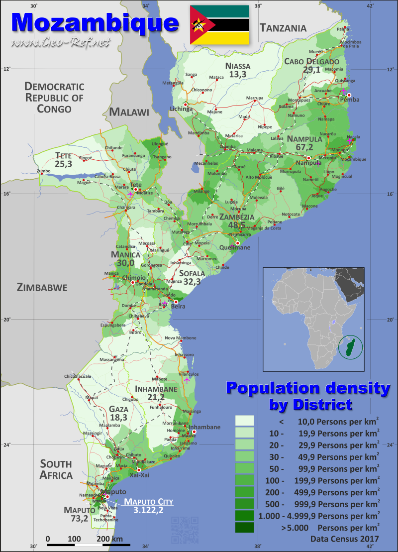
Mozambique map - Click the map to get map as PDF file.
Other language versions are easy to generate, the descriptions are in own layers
Conditions for thematic maps with your own data and logotype
Delivery as printable file by e-mail or plot by post office
|
|---|
| Layers | |
| Provinces: | yes |
| Streets: | yes |
| Infrastructure: | yes |
| Rivers: | yes |
|
| Size | Till A2 |
| Delivery time | 7 working days | | Price |
| 1 bis 3 | 65 € | | > 3 | On request |
|
 |
All information published herein is free usable quoting the source,
including the maps, if they are not modified
|
|---|
Statistical data - Population density according to the administrative structure
The population data of the table below is census data from 2017, last available data.
Click on the column header brings the table in order of the column header.
The default order is the province name.
| Province |
ISO
3166-2 |
Capital |
Area
(km²) |
Population |
Density
(pers/km²) |
| Total |
|
|
780 508 |
26 899 103 |
34,5 |
|---|
| Last update: 12.06.2025 - 08:44:38 |
|---|
| Cabo Delgado |
MZ-P |
Pemba |
77 899 |
2 267 715 |
29,1 |
| Gaza |
MZ-G |
Xai-Xai |
75 386 |
1 388 039 |
18,4 |
| Inhambane |
MZ-I |
Inhambane |
68 785 |
1 454 804 |
21,2 |
| Manica |
MZ-B |
Chimoio |
62 317 |
1 851 931 |
29,7 |
| Maputo |
MZ-L |
Matola |
23 276 |
1 908 078 |
82,0 |
| Maputo City |
MZ-MPM |
- |
348 |
1 080 277 |
3 104,2 |
| Nampula |
MZ-N |
Nampula |
78 176 |
5 483 382 |
70,1 |
| Niassa |
MZ-A |
Lichinga |
122 794 |
1 713 751 |
14,0 |
| Sofala |
MZ-S |
Beira |
67 750 |
2 196 845 |
32,4 |
| Tete |
MZ-T |
Tete |
100 702 |
2 551 824 |
25,3 |
| Zambezia |
MZ-Q |
Quelimane |
103 075 |
5 002 457 |
48,5 |
The provinces are divided into districts, the data of which are shown in the table below
| District |
HASC |
Province |
Capital
| Area
(km²) |
Population |
Density
(pers/km²) |
| Total |
|
|
|
780 508 |
26 899 105 |
34,5 |
|---|
| Last update: 12.06.2025 - 08:44:38 |
|---|
| Alto Molócuè |
ZA.AM |
Zambézia |
Molócue |
6 340 |
345 559 |
54,5 |
| Ancuabe |
CD.AN |
Cabo Delgado |
Ancuabe |
4 921 |
159 340 |
32,4 |
| Angoche |
NM.AN |
Nampula |
Angoche |
3 019 |
347 176 |
115,0 |
| Angónia |
TE.AN |
Tete |
Ulongué |
3 261 |
472 164 |
144,8 |
| Balama |
CD.BA |
Cabo Delgado |
Balama |
5 498 |
175 733 |
32,0 |
| Báruè |
MN.BA |
Manica |
Catandica |
5 775 |
185 641 |
32,1 |
| Beira |
n.d. |
Sofala |
Beira |
631 |
592 090 |
938,3 |
| Bilene |
n.d. |
Gaza |
Bilene |
2 182 |
140 972 |
64,6 |
| Boane |
MP.BO |
Maputo |
Boane |
805 |
210 367 |
261,3 |
| Búzi |
SO.BU |
Sofala |
Búzi |
7 227 |
177 415 |
24,5 |
| Cahora-Bassa |
TE.CB |
Tete |
Chitima |
8 847 |
128 768 |
14,6 |
| Caia |
SO.CA |
Sofala |
Caia |
3 584 |
158 256 |
44,2 |
| Changara |
TE.CG |
Tete |
Luenha |
6 148 |
123 056 |
20,0 |
| Chemba |
SO.CM |
Sofala |
Chemba |
3 978 |
83 257 |
20,9 |
| Cheringoma |
SO.CR |
Sofala |
Cheringoma |
7 104 |
57 572 |
8,1 |
| Chibabava |
SO.CB |
Sofala |
Chibabava |
6 995 |
135 202 |
19,3 |
| Chibuto |
GA.CB |
Gaza |
Chibuto |
5 606 |
217 155 |
38,7 |
| Chicualacuala |
GA.CC |
Gaza |
Chicualacuala |
11 393 |
27 084 |
2,4 |
| Chifunde |
TE.CF |
Tete |
Chifunde |
9 405 |
157 647 |
16,8 |
| Chigubo |
GA.CG |
Gaza |
Dindiza |
15 040 |
22 080 |
1,5 |
| Chimbonila |
n.d. |
Niassa |
Chimbonila |
5 418 |
72 503 |
13,4 |
| Chimoio |
n.d. |
Manica |
Chimoio |
174 |
363 336 |
2 088,1 |
| Chinde |
ZA.CH |
Zambézia |
Chinde |
3 117 |
85 972 |
27,6 |
| Chiúre |
CD.CH |
Cabo Delgado |
Chiúre |
5 372 |
299 235 |
55,7 |
| Chiuta |
TE.CT |
Tete |
Manje |
7 125 |
101 341 |
14,2 |
| Chókwè |
GA.CK |
Gaza |
Chókwè |
2 445 |
217 019 |
88,8 |
| Chongoene |
n.d. |
Gaza |
Chongoene |
747 |
118 911 |
159,2 |
| Cuamba |
NS.CU |
Niassa |
Cuamba |
5 344 |
267 928 |
50,1 |
| Derre |
n.d. |
Zambézia |
Derre |
4 747 |
109 582 |
23,1 |
| Doa |
n.d. |
Tete |
Doa |
3 634 |
87 077 |
24,0 |
| Dondo |
SO.DO |
Sofala |
Dondo |
2 308 |
193 382 |
83,8 |
| Erá¡ti |
n.d. |
Nampula |
Erá¡ti |
5 701 |
387 713 |
68,0 |
| Funhalouro |
IN.FU |
Inhambane |
Funhalouro |
13 622 |
44 140 |
3,2 |
| Gilé |
ZA.GI |
Zambézia |
Gilé |
8 977 |
213 614 |
23,8 |
| Gondola |
MN.GO |
Manica |
Gondola |
3 990 |
192 314 |
48,2 |
| Gorongosa |
SO.GO |
Sofala |
Gorongosa |
6 778 |
176 845 |
26,1 |
| Govuro |
IN.GO |
Inhambane |
Nova Mambone |
3 967 |
36 094 |
9,1 |
| Guijá |
GA.GU |
Gaza |
Canicado |
4 191 |
89 996 |
21,5 |
| Guro |
MN.GU |
Manica |
Guro |
6 930 |
97 141 |
14,0 |
| Gurué |
ZA.GU |
Zambézia |
Gurué |
5 644 |
417 329 |
73,9 |
| Homoine |
IN.HO |
Inhambane |
Vila deHomoine |
1 917 |
114 877 |
59,9 |
| Ibo |
CD.IB |
Cabo Delgado |
Vila do Ibo |
74 |
12 205 |
164,9 |
| Ile |
ZA.IL |
Zambézia |
Ile |
2 934 |
192 660 |
65,7 |
| Ilha de Mocambique |
NM.IM |
Nampula |
Ilha de Mocambique |
181 |
64 577 |
356,8 |
| Inhambane |
n.d. |
Inhambane |
Inhambane |
195 |
82 119 |
421,1 |
| Inharrime |
IN.IR |
Inhambane |
Inharrime |
2 748 |
113 288 |
41,2 |
| Inhassoro |
IN.IS |
Inhambane |
Inhassoro |
4 745 |
57 037 |
12,0 |
| Inhassunge |
ZA.IN |
Zambézia |
Mucupia |
755 |
89 893 |
119,1 |
| Jangamo |
IN.JA |
Inhambane |
Jangamo |
1 293 |
105 306 |
81,4 |
| KaMavota (Distrito 4) |
MC.DQ |
Maputo City |
Maputo |
80 |
326 771 |
4 084,6 |
| KaMaxakeni (Distrito 3) |
MC.DT |
Maputo City |
Maputo |
13 |
195 556 |
15 042,8 |
| KaMphumu (Distrito 1) |
MC.KP |
Maputo City |
Maputo |
14 |
76 157 |
5 439,8 |
| KaMubukwana (Distrito 5) |
MC.DC |
Maputo City |
Maputo |
61 |
319 968 |
5 245,4 |
| KaNyaka (Inhaca) |
MC.KY |
Maputo City |
Maputo |
48 |
5 958 |
124,1 |
| KaTembe (Catembe) |
MC.KT |
Maputo City |
Maputo |
122 |
28 788 |
236,0 |
| Lago |
NS.LA |
Niassa |
Metangula |
6 555 |
106 968 |
16,3 |
| Lalaua |
NM.LA |
Nampula |
Lalaua |
4 532 |
107 369 |
23,7 |
| Larde |
n.d. |
Nampula |
Larde |
1 844 |
98 385 |
53,4 |
| Lichinga |
NS.LI |
Niassa |
Lichinga |
256 |
242 204 |
946,1 |
| Limpopo |
n.d. |
Gaza |
Limpopo |
1 119 |
150 394 |
134,4 |
| Liúpo |
n.d. |
Nampula |
Liúpo |
2 121 |
89 259 |
42,1 |
| Luabo |
n.d. |
Zambézia |
Luabo |
1 120 |
58 212 |
52,0 |
| Lugela |
ZA.LU |
Zambézia |
Lugela |
6 128 |
182 203 |
29,7 |
| Mabalane |
GA.MB |
Gaza |
Mabalane |
8 929 |
38 644 |
4,3 |
| Mabote |
IN.MB |
Inhambane |
Mabote |
15 335 |
51 046 |
3,3 |
| Macanga |
TE.MC |
Tete |
Furancungo |
7 197 |
158 881 |
22,1 |
| Macate |
n.d. |
Manica |
Macate |
1 780 |
84 429 |
47,4 |
| Machanga |
SO.MC |
Sofala |
Machanga |
5 716 |
55 848 |
9,8 |
| Machaze |
MN.MZ |
Manica |
Machaze |
13 296 |
126 488 |
9,5 |
| Macomia |
CD.MA |
Cabo Delgado |
Macomia |
4 191 |
114 345 |
27,3 |
| Macossa |
MN.MS |
Manica |
Macossa |
9 564 |
46 132 |
4,8 |
| Maganja da Costa |
ZA.MC |
Zambézia |
Maganja da Costa |
2 873 |
144 974 |
50,5 |
| Magoé |
TE.MG |
Tete |
Mpheende |
8 554 |
89 273 |
10,4 |
| Magude |
MP.MG |
Maputo |
Magude |
6 966 |
62 297 |
8,9 |
| Majune |
NS.MJ |
Niassa |
Majune |
11 298 |
40 004 |
3,5 |
| Malema |
NM.MA |
Nampula |
Malema |
6 053 |
213 011 |
35,2 |
| Mandimba |
NS.MN |
Niassa |
Mandimba |
4 681 |
211 979 |
45,3 |
| Mandlakaze |
GA.MJ |
Gaza |
Mandlakaze |
3 687 |
137 068 |
37,2 |
| Manhica |
MP.MN |
Maputo |
Manhica |
2 366 |
205 053 |
86,7 |
| Manica |
MN.MN |
Manica |
Manica |
2 534 |
215 239 |
84,9 |
| Mapai |
n.d. |
Gaza |
Mapai |
6 682 |
28 441 |
4,3 |
| Marara |
n.d. |
Tete |
Marara |
2 716 |
73 044 |
26,9 |
| Marávia |
TE.MR |
Tete |
Fingoé |
16 705 |
126 630 |
7,6 |
| Maringué |
SO.MG |
Sofala |
Maringué |
6 150 |
95 362 |
15,5 |
| Marracuene |
MP.MR |
Maputo |
Marracuene |
697 |
218 788 |
313,9 |
| Marromeu |
SO.MM |
Sofala |
Marromeu |
5 753 |
154 361 |
26,8 |
| Marrupa |
NS.MR |
Niassa |
Marrupa |
17 808 |
77 808 |
4,4 |
| Massangena |
GA.MS |
Gaza |
Massangena |
7 545 |
21 562 |
2,9 |
| Massinga |
IN.MS |
Inhambane |
Massinga |
7 408 |
236 939 |
32,0 |
| Massingir |
GA.MG |
Gaza |
Massingir |
5 685 |
36 750 |
6,5 |
| Matola |
MP.MT |
Maputo |
Matola |
368 |
1 032 197 |
2 804,9 |
| Matutuíne |
NS.MU |
Maputo |
Matutuíne |
5 342 |
43 664 |
8,2 |
| Maúa |
NS.MV |
Niassa |
Maúa |
8 047 |
68 260 |
8,5 |
| Mavago |
n.d. |
Niassa |
Mavago |
9 195 |
29 933 |
3,3 |
| Maxixe |
n.d. |
Inhambane |
Maxixe |
268 |
129 993 |
485,0 |
| Mecanhelas |
NS.MS |
Niassa |
Mecanhelas |
5 011 |
269 619 |
53,8 |
| Meconta |
NM.MC |
Nampula |
Meconta |
3 677 |
223 760 |
60,9 |
| Mecubúri |
NM.MB |
Nampula |
Mecubúri |
7 190 |
207 285 |
28,8 |
| Mecúfi |
CD.MC |
Cabo Delgado |
Mecúfi |
1 235 |
61 531 |
49,8 |
| Mecula |
NS.MC |
Niassa |
Mecula |
18 016 |
20 888 |
1,2 |
| Meluco |
CD.ML |
Cabo Delgado |
Meluco |
5 729 |
36 700 |
6,4 |
| Memba |
NM.MM |
Nampula |
Memba |
4 450 |
328 460 |
73,8 |
| Metarica |
NS.MT |
Niassa |
Metarica |
4 860 |
45 303 |
9,3 |
| Metuge |
n.d. |
Cabo Delgado |
Metuge |
1 588 |
86 866 |
54,7 |
| Milange |
ZA.ML |
Zambézia |
Milange |
5 505 |
595 580 |
108,2 |
| Moamba |
MP.MO |
Maputo |
Moamba |
4 580 |
88 583 |
19,3 |
| Moatize |
TE.MT |
Tete |
Moatize |
8 433 |
260 843 |
30,9 |
| Mocímboa da Praia |
CD.MP |
Cabo Delgado |
Mocímboa da Praia |
3 473 |
127 705 |
36,8 |
| Mocuba |
ZA.MB |
Zambézia |
Mocuba |
8 773 |
399 551 |
45,5 |
| Mocubela |
n.d. |
Zambézia |
Mocubela |
4 761 |
120 815 |
25,4 |
| Mogincual |
NM.MG |
Nampula |
Mogincual |
2 283 |
98 177 |
43,0 |
| Mogovolas |
NM.MV |
Nampula |
Nametil |
4 711 |
368 905 |
78,3 |
| Molumbo |
n.d. |
Zambézia |
Molumbo |
4 320 |
321 007 |
74,3 |
| Moma |
NM.MO |
Nampula |
Moma |
3 911 |
324 442 |
83,0 |
| Monapo |
NM.MN |
Nampula |
Monapo |
3 515 |
393 813 |
112,0 |
| Montepuez |
CD.MN |
Cabo Delgado |
Montepuez |
17 806 |
272 069 |
15,3 |
| Mopeia |
ZA.MP |
Zambézia |
Mopeia |
7 657 |
153 355 |
20,0 |
| Morrumbala |
ZA.MR |
Zambézia |
Morrumbala |
8 036 |
369 193 |
45,9 |
| Morrumbene |
IN.MO |
Inhambane |
Morrumbene |
2 579 |
136 980 |
53,1 |
| Mossuril |
NM.MS |
Nampula |
Mossuril |
3 381 |
174 641 |
51,7 |
| Mossurize |
MN.MO |
Manica |
Espungabera |
5 023 |
203 738 |
40,6 |
| Muanza |
SO.MU |
Sofala |
Muanza |
7 510 |
38 174 |
5,1 |
| Muecate |
NM.MU |
Nampula |
Muecate |
4 106 |
134 280 |
32,7 |
| Mueda |
CD.MD |
Cabo Delgado |
Mueda |
11 227 |
170 347 |
15,2 |
| Muembe |
NS.MM |
Niassa |
Muembe |
5 802 |
43 787 |
7,5 |
| Muidumbe |
CD.MB |
Cabo Delgado |
Muidumbe |
2 096 |
98 864 |
47,2 |
| Mulevala |
NM.MR |
Zambézia |
Mulevala |
2 701 |
105 640 |
39,1 |
| Murrupula |
n.d. |
Nampula |
Murrupula |
3 094 |
184 732 |
59,7 |
| Mutarara |
TE.MU |
Tete |
Nhamayabue |
2 732 |
168 058 |
61,5 |
| Nacala (Nacala Porto) |
n.d. |
Nampula |
Nacala |
319 |
287 536 |
901,4 |
| Nacala-a-Velha |
NM.NV |
Nampula |
Nacala-a-Velha |
1 133 |
121 726 |
107,4 |
| Nacaroa |
NM.NR |
Nampula |
Nacaroa |
2 714 |
145 450 |
53,6 |
| Namaacha |
MP.NA |
Maputo |
Namaacha |
2 152 |
47 129 |
21,9 |
| Namacurra |
ZA.NC |
Zambézia |
Namacurra |
2 021 |
214 924 |
106,3 |
| Namarroi |
ZA.NR |
Zambézia |
Namarroi |
3 061 |
142 095 |
46,4 |
| Nampula |
n.d. |
Nampula |
Nampula |
330 |
760 214 |
2 303,7 |
| Namuno |
CD.NM |
Cabo Delgado |
Namuno |
5 981 |
245 248 |
41,0 |
| Nangade |
CD.NG |
Cabo Delgado |
Nangade |
2 967 |
89 714 |
30,2 |
| N'gauma |
NS.NG |
Niassa |
Massangulo |
3 005 |
95 823 |
31,9 |
| Nhamatanda |
SO.NH |
Sofala |
Nhamatanda |
4 016 |
279 081 |
69,5 |
| Nicoadala |
ZA.NI |
Zambézia |
Nicoadala |
3 381 |
186 761 |
55,2 |
| Nipepe |
NS.NI |
Niassa |
Nipepe |
5 001 |
45 086 |
9,0 |
| Nlhamankulu (Distrito 2) |
MC.DD |
Maputo City |
Maputo |
10 |
127 079 |
12 707,9 |
| Palma |
CD.PA |
Cabo Delgado |
Palma |
3 523 |
67 025 |
19,0 |
| Panda |
IN.PA |
Inhambane |
Panda |
6 843 |
43 968 |
6,4 |
| Pebane |
ZA.PE |
Zambézia |
Pebane |
10 102 |
205 631 |
20,4 |
| Pemba |
CD.PM |
Cabo Delgado |
Pemba |
100 |
200 529 |
2 005,3 |
| Quelimane |
CD.QU |
Zambézia |
Quelimane |
122 |
347 907 |
2 851,7 |
| Quissanga |
n.d. |
Cabo Delgado |
Quissanga |
2 118 |
50 259 |
23,7 |
| Rapale |
NM.RN |
Nampula |
Rapale |
3 662 |
166 327 |
45,4 |
| Ribáué |
NM.RI |
Nampula |
Ribáué |
6 249 |
256 144 |
41,0 |
| Sanga |
NS.SA |
Niassa |
Sanga |
12 497 |
75 658 |
6,1 |
| Sussundenga |
MN.SU |
Manica |
Sussundenga |
7 113 |
168 442 |
23,7 |
| Tambara |
MN.TA |
Manica |
Nhacolo |
4 285 |
53 499 |
12,5 |
| Tete |
n.d. |
Tete |
Tete |
287 |
307 338 |
1 070,9 |
| Tsangano |
TE.TS |
Tete |
Tsangano |
3 662 |
214 560 |
58,6 |
| Vanduzi |
n.d. |
Manica |
Vanduzi |
1 853 |
115 532 |
62,3 |
| Vilankulo |
IN.VI |
Inhambane |
Vilankulo |
5 854 |
151 709 |
25,9 |
| Xai-Xai |
GA.XX |
Gaza |
Xai-Xai |
135 |
141 963 |
1 051,6 |
| Zavala |
IN.ZA |
Inhambane |
Zavala |
2 011 |
151 308 |
75,2 |
| Zumbo |
TE.ZU |
Tete |
Zumbo |
11 996 |
83 144 |
6,9 |
Existing thematic maps
|
External links change quickly - If you get a link error - Please inform us!
 |
Membership in international organisations and treaties
Expand list
Political Alliances
Regional Unions
Military alliances/Arms control
Law enforcement
Business Alliances
Fishery
Financial
Free Trade Area, Internal Market
Technical alliances
Transport
Cientific
Humanitarian Unions
Cultural Unions
|
|
If you have suggestions to include other information or you find missed links, please inform us!
Click here ... |
International Border disputes
Expand list
See also neighboring states
|
| |


