Department of Mayotte
| Capital |
Currency | Government system |
|---|
| Mamoudzou |
Euro (EUR) |
Dependent from France |
| Official language | Region |
Population |
|---|
| French |
Africa |
Census 2017
256 518 |
Country map - Administrative structure - Population density of Mayotte
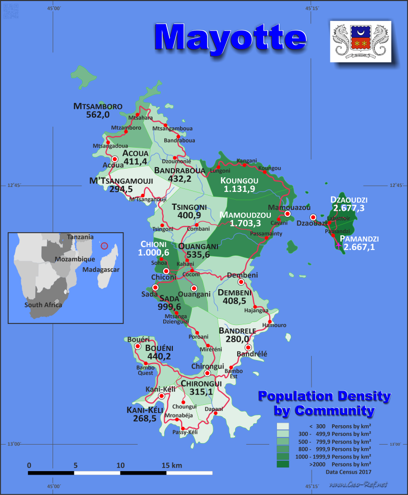
Mayotte map - Click the map to get map as PDF file.
Other language versions are easy to generate, the descriptions are in own layers
Conditions for thematic maps with your own data and logotype
Delivery as printable file by e-mail or plot by post office
|
|---|
| Layers | |
| Provinces: | yes |
| Streets: | yes |
| Infrastructure: | yes |
| Rivers: | yes |
|
| Size | Till A2 |
| Delivery time | 7 working days | | Price |
| 1 bis 3 | 75 € | | > 3 | On request |
|
 |
All information published herein is free usable quoting the source,
including the maps, if they are not modified
|
|---|
Statistical data - Population density according to the administrative structure
The population data of the table below is census data from 2017, last available data.
Mayotte is part of the France, therefore are no ISO values assigned, instead are here the French INSEE code.
Click on the column header brings the table in order of the column header.
The default order is the community name.
| Community |
INSEE |
Capital |
Area
(km²) |
Population |
Density
(pers/km²) |
| Total |
|
|
373,2 |
256 518 |
687,3 |
|---|
| Last update: 17.01.2023 - 22:59:28 |
|---|
| Acoua |
97601 |
Acoua |
12,6 |
5 192 |
411,4 |
| Bandraboua |
97602 |
Bandraboua |
32,4 |
13 989 |
432,2 |
| Bandrélé |
97603 |
Bandrélé |
36,5 |
10 282 |
282,0 |
| Bouéni |
97604 |
Bouéni |
14,1 |
6 189 |
440,2 |
| Chiconi |
97605 |
Chiconi |
8,3 |
8 295 |
1 000,6 |
| Chirongui |
97606 |
Chirongui |
28,3 |
8 920 |
315,1 |
| Dembéni |
97607 |
Dembéni |
38,8 |
15 848 |
408,5 |
| Dzaoudzi |
97608 |
Dzaoudzi |
6,7 |
17 831 |
2 677,3 |
| Kani-Kéli |
97609 |
Kani-Kéli |
20,5 |
5 507 |
268,5 |
| Koungou |
97610 |
Koungou |
28,4 |
32 156 |
1 131,9 |
| M´tsangamouji |
97613 |
M´tsangamouji |
21,8 |
6 432 |
294,5 |
| Mamoudzou |
97611 |
Mamoudzou |
41,9 |
71 437 |
1 703,3 |
| Mtsamboro |
97612 |
Mtsamboro |
13,7 |
7 705 |
562,0 |
| Ouangani |
97614 |
Ouangani |
19,1 |
10 203 |
535,6 |
| Pamandzi |
97615 |
Pamandzi |
4,3 |
11 442 |
2 667,1 |
| Sada |
97616 |
Sada |
11,2 |
11 156 |
999,6 |
| Tsingoni |
97617 |
Tsingoni |
34,8 |
13 934 |
400,9 |
Existing thematic maps
|
External links change quickly - If you get a link error - Please inform us!
 |
Membership in international organisations and treaties
Expand list
Technical alliances
|
|
If you have suggestions to include other information or you find missed links, please inform us!
Click here ... |
See also neighboring states
|


