Republic of Kenya
| Capital |
Currency | Government system |
|---|
| Nairobi |
Kenyan Shilling (KES) |
Presidential system |
| Official language | Region |
Population |
|---|
Swahili
English |
Africa |
Estimation 2023
51 525 585 |
Country map - Administrative structure - Population density of Kenya
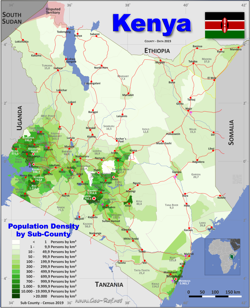
Kenya map - Click the map to get map as PDF file.
Other language versions are easy to generate, the descriptions are in own layers
Conditions for thematic maps with your own data and logotype
Delivery as printable file by e-mail or plot by post office
|
|---|
| Layers | |
| Provinces: | yes |
| Streets: | yes |
| Infrastructure: | yes |
| Rivers: | yes |
|
| Size | Till A2 |
| Delivery time | 7 working days | | Price |
| 1 bis 3 | 75 € | | > 3 | On request |
|
 |
All information published herein is free usable quoting the source,
including the maps, if they are not modified
|
|---|
Statistical data - Population density according to the administrative structure
The population data of the table below is an estimation form 2023, based on the census 2019.
Click on the column header brings the table in order of the column header.
The default order is the county name.
| County |
ISO
3166-2 |
Province |
Capital |
Area
(km²) |
Population |
Density
(pers/km²) |
| Total |
|
|
|
580 749 |
51 525 585 |
88,7 |
|---|
| Last update: 11/04/202 - 00:44:05 |
|---|
| Baringo |
KE-01 |
Rift Valley |
Kabarnet |
10 977 |
733 333 |
66,8 |
| Bomet |
KE-02 |
Rift Valley |
Bomet |
2 531 |
939 761 |
371,3 |
| Bungoma |
KE-03 |
Western |
Bungoma |
3 024 |
1 786 973 |
590,9 |
| Busia |
KE-04 |
Western |
Busia |
1 696 |
968 763 |
571,1 |
| Elgeyo Marakwet |
KE-05 |
Rift Valley |
Iten |
3 032 |
495 239 |
163,3 |
| Embu |
KE-06 |
Eastern |
Embu |
2 821 |
648 425 |
229,9 |
| Garissa |
KE-07 |
North Eastern |
Garissa |
44 736 |
927 031 |
20,7 |
| Homa Bay |
KE-08 |
Nyanza |
Homa Bay |
3 152 |
1 231 659 |
390,7 |
| Isiolo |
KE-09 |
Eastern |
Isiolo |
25 350 |
315 937 |
12,5 |
| Kajiado |
KE-10 |
Rift Valley |
Kajiado |
21 873 |
1 268 261 |
58,0 |
| Kakamega |
KE-11 |
Western |
Kakamega |
3 020 |
2 002 435 |
663,0 |
| Kericho |
KE-12 |
Rift Valley |
Kericho |
2 436 |
954 896 |
392,0 |
| Kiambu |
KE-13 |
Central |
Kiambu |
2 539 |
2 652 880 |
1 045,0 |
| Kilifi |
KE-14 |
Coast |
Kilifi |
12 539 |
1 577 335 |
125,8 |
| Kirinyaga |
KE-15 |
Central |
Kerugoya |
1 478 |
653 112 |
441,8 |
| Kisii |
KE-16 |
Nyanza |
Kisii |
1 323 |
1 344 907 |
1 016,6 |
| Kisumu |
KE-17 |
Nyanza |
Kisumu |
2 085 |
1 248 474 |
598,7 |
| Kitui |
KE-18 |
Eastern |
Kitui |
30 430 |
1 229 790 |
40,4 |
| Kwale |
KE-19 |
Coast |
Kwale |
8 267 |
944 464 |
114,2 |
| Laikipia |
KE-20 |
Rift Valley |
Nanyuki |
9 532 |
561 223 |
58,9 |
| Lamu |
KE-21 |
Coast |
Lamu |
6 254 |
167 332 |
26,8 |
| Machakos |
KE-22 |
Eastern |
Machakos |
6 042 |
1 487 758 |
246,2 |
| Makueni |
KE-23 |
Eastern |
Wote |
8 170 |
1 042 300 |
127,6 |
| Mandera |
KE-24 |
North Eastern |
Mandera |
25 940 |
959 236 |
37,0 |
| Marsabit |
KE-25 |
Eastern |
Marsabit |
70 945 |
515 292 |
7,3 |
| Meru |
KE-26 |
Eastern |
Meru |
7 006 |
1 625 982 |
232,1 |
| Migori |
KE-27 |
Nyanza |
Migori |
2 614 |
1 234 082 |
472,2 |
| Mombasa |
KE-28 |
Coast |
Mombasa |
220 |
1 311 860 |
5 965,7 |
| Murang´a |
KE-29 |
Central |
Murang'a |
2 524 |
1 112 288 |
440,7 |
| Nairobi City |
KE-30 |
Nairobi |
Nairobi |
704 |
4 750 056 |
6 750,1 |
| Nakuru |
KE-31 |
Rift Valley |
Nakuru |
7 462 |
2 347 849 |
314,7 |
| Nandi |
KE-32 |
Rift Valley |
Kapsabet |
2 856 |
951 460 |
333,2 |
| Narok |
KE-33 |
Rift Valley |
Narok |
17 950 |
1 284 204 |
71,5 |
| Nyamira |
KE-34 |
Nyanza |
Nyamira |
897 |
657 502 |
732,8 |
| Nyandarua |
KE-35 |
Central |
Ol Kalou |
3 155 |
695 531 |
220,4 |
| Nyeri |
KE-36 |
Central |
Nyeri |
3 325 |
835 408 |
251,3 |
| Samburu |
KE-37 |
Rift Valley |
Maralal |
21 065 |
348 298 |
16,5 |
| Siaya |
KE-38 |
Nyanza |
Siaya |
2 530 |
1 059 458 |
418,8 |
| Taita Taveta |
KE-39 |
Coast |
Wundanyi |
17 153 |
363 990 |
21,2 |
| Tana River |
KE-40 |
Coast |
Hola |
37 951 |
352 549 |
9,3 |
| Tharaka Nithi |
KE-41 |
Eastern |
Kathwana |
2 564 |
416 383 |
162,4 |
| Trans Nzoia |
KE-42 |
Rift Valley |
Kitale |
2 495 |
1 069 039 |
428,5 |
| Turkana |
KE-43 |
Rift Valley |
Lodwar |
68 233 |
1 022 773 |
15,0 |
| Uasin Gishu |
KE-44 |
Rift Valley |
Eldoret |
3 392 |
1 257 330 |
370,7 |
| Vihiga |
KE-45 |
Western |
Mbale |
564 |
625 765 |
1 110,1 |
| Wajir |
KE-46 |
North Eastern |
Wajir |
56 774 |
870 636 |
15,3 |
| West Pokot |
KE-47 |
Rift Valley |
Kapenguria |
9 123 |
676 326 |
74,1 |
The counties are subdivided into subcounties, whose data for the census 2017 are shown in the following table. The capitals of the subcounties are from informal sources - an official designation could not be determined so far.
| Subcounty |
Own |
County |
Capital
| Area
(km²) |
Population |
Density
(pers/km²) |
| Total |
|
|
|
580 749,0 |
47 564 296,0 |
81,9 |
|---|
| Last update: 11/04/202 - 00:44:05 |
|---|
| Aberdare National Park |
35-01 |
Nyandarua |
n d |
716,7 |
15 |
0,0 |
| Aberdare National Park |
29-01 |
Murang'a |
Gatare |
294,7 |
43 |
0,1 |
| Aberdare National Park |
36-01 |
Nyeri |
Rware |
722,0 |
106 |
0,1 |
| Ainabkoi |
44-01 |
Uasin Gishu |
Kaptagat |
492,9 |
138 184 |
280,3 |
| Athi River |
22-01 |
Machakos |
Athi River |
827,2 |
322 499 |
389,9 |
| Awendo |
27-01 |
Migori |
Sare |
255,3 |
117 290 |
459,4 |
| Balambala |
07-01 |
Garissa |
Bahadale |
3 684,0 |
32 257 |
8,8 |
| Banisa |
24-01 |
Mandera |
Banisa |
3 943,0 |
152 598 |
38,7 |
| Baringo Central |
01-01 |
Baringo |
Kabarnet |
786,5 |
96 951 |
123,3 |
| Baringo North |
01-02 |
Baringo |
Loruk |
1 629,0 |
104 871 |
64,4 |
| Belgut |
12-01 |
Kericho |
Kapsuser |
264,3 |
145 072 |
548,9 |
| Bomet Central |
02-01 |
Bomet |
Bomet |
286,1 |
175 215 |
612,4 |
| Bomet East |
02-02 |
Bomet |
Longisa |
305,0 |
144 275 |
473,0 |
| Bondo |
38-01 |
Siaya |
Bondo |
598,8 |
197 883 |
330,5 |
| Borabu |
34-01 |
Nyamira |
Nyansiongo |
246,9 |
73 167 |
296,3 |
| Bumula |
03-01 |
Bungoma |
Kimaeti |
345,2 |
215 892 |
625,4 |
| Buna |
46-01 |
Wajir |
Buna |
3 893,0 |
49 886 |
12,8 |
| Bungoma Central |
03-02 |
Bungoma |
Chwele |
232,7 |
177 748 |
763,9 |
| Bungoma East |
03-03 |
Bungoma |
Webuye |
163,3 |
114 548 |
701,5 |
| Bungoma North |
03-04 |
Bungoma |
Natiri Corner |
191,5 |
121 317 |
633,5 |
| Bungoma South |
03-05 |
Bungoma |
Bungoma |
321,2 |
287 765 |
895,9 |
| Bungoma West |
03-06 |
Bungoma |
Sirisia |
211,0 |
119 875 |
568,1 |
| Bunyala |
04-01 |
Busia |
Port Bunyala |
192,2 |
85 977 |
447,3 |
| Bureti |
12-02 |
Kericho |
Litein |
320,6 |
199 470 |
622,2 |
| Busia |
04-02 |
Busia |
Busia |
196,0 |
142 408 |
726,6 |
| Butere |
11-01 |
Kakamega |
Butere |
210,1 |
154 100 |
733,5 |
| Butula |
04-03 |
Busia |
Butula |
243,6 |
140 334 |
576,1 |
| Buuri East |
26-01 |
Meru |
Muchiene |
332,9 |
76 598 |
230,1 |
| Buuri West |
26-02 |
Meru |
Timau |
638,7 |
80 762 |
126,4 |
| Changamwe |
28-01 |
Mombasa |
Mombasa |
17,7 |
131 882 |
7 451,0 |
| Chepalungu |
02-03 |
Bomet |
Sigor |
460,5 |
164 837 |
358,0 |
| Cheptais |
03-07 |
Bungoma |
Chesakaki |
222,9 |
136 035 |
610,3 |
| Chesumei |
32-01 |
Nandi |
Mosoriot |
474,6 |
164 133 |
345,8 |
| Chonyi |
14-01 |
Kilifi |
Galanema |
192,6 |
62 335 |
323,7 |
| Dadaab |
07-02 |
Garissa |
Liboi |
6 480,0 |
185 252 |
28,6 |
| Dagoretti |
30-01 |
Nairobi |
Nairobi |
29,1 |
434 208 |
14 921,2 |
| East Pokot |
01-03 |
Baringo |
Kolowa |
2 501,0 |
79 923 |
32,0 |
| Eldas |
46-02 |
Wajir |
Eldas |
4 444,0 |
89 104 |
20,1 |
| Embakasi |
30-02 |
Nairobi |
Nairobi |
86,3 |
988 808 |
11 457,8 |
| Embu East |
06-01 |
Embu |
Runyenjes |
253,3 |
129 564 |
511,5 |
| Embu North |
06-02 |
Embu |
Manyatta |
110,6 |
79 556 |
719,3 |
| Embu West |
06-03 |
Embu |
Embu |
158,1 |
127 100 |
803,9 |
| Emuhaya |
45-01 |
Vihiga |
Buyangu |
89,0 |
97 141 |
1 091,5 |
| Endebess |
42-01 |
Trans Nzoia |
Endebess |
678,4 |
111 782 |
164,8 |
| Etago |
16-01 |
Kisii |
Nyaramba |
108,4 |
83 787 |
772,9 |
| Fafi |
07-03 |
Garissa |
n d |
15 073,0 |
134 040 |
8,9 |
| Ganze |
14-02 |
Kilifi |
Jaribuni |
3 204,0 |
143 906 |
44,9 |
| Garbatulla |
09-01 |
Isiolo |
Ndodyo |
9 902,0 |
99 730 |
10,1 |
| Garissa |
07-04 |
Garissa |
Garissa |
3 231,0 |
163 914 |
50,7 |
| Gatanga |
29-02 |
Murang'a |
Mugumoini |
532,3 |
187 989 |
353,2 |
| Gatundu North |
13-01 |
Kiambu |
Gachege |
285,9 |
109 870 |
384,3 |
| Gatundu South |
13-02 |
Kiambu |
Gatundu |
193,6 |
122 103 |
630,7 |
| Gem |
38-02 |
Siaya |
Yala |
405,3 |
179 792 |
443,6 |
| Gilgil |
31-01 |
Nakuru |
Gilgil |
1 075,0 |
185 209 |
172,3 |
| Githunguri |
13-03 |
Kiambu |
Githunguri |
174,4 |
165 232 |
947,4 |
| Gucha |
16-02 |
Kisii |
Ogembo |
82,1 |
83 740 |
1 020,0 |
| Gucha South |
16-03 |
Kisii |
Tabaka |
94,9 |
83 623 |
881,2 |
| Habaswein |
46-03 |
Wajir |
Habaswein |
10 913,0 |
174 134 |
16,0 |
| Hamisi |
45-02 |
Vihiga |
Giasmbai |
188,9 |
159 258 |
843,1 |
| Homa Bay |
08-01 |
Homa Bay |
Homa Bay |
182,0 |
117 439 |
645,3 |
| Hulugho |
07-05 |
Garissa |
Hulugho |
7 733,0 |
133 984 |
17,3 |
| Igambang'ombe |
41-01 |
Tharaka-Nithi |
Kathwana |
324,6 |
53 210 |
163,9 |
| Igembe Central |
26-03 |
Meru |
Kangeta |
604,1 |
221 412 |
366,5 |
| Igembe North |
26-04 |
Meru |
Laare |
1 077,0 |
169 317 |
157,2 |
| Igembe South |
26-05 |
Meru |
Maua |
255,2 |
161 646 |
633,4 |
| Ijara |
07-06 |
Garissa |
Ijara |
2 439,0 |
141 591 |
58,1 |
| Ikutha |
18-01 |
Kitui |
Ikutha |
9 033,0 |
82 964 |
9,2 |
| Imenti North |
26-06 |
Meru |
Meru |
230,8 |
177 567 |
769,4 |
| Imenti South |
26-07 |
Meru |
Mwichiune |
413,9 |
206 506 |
498,9 |
| Isinya |
10-01 |
Kajiado |
Isinya |
1 072,0 |
210 473 |
196,3 |
| Isiolo |
09-02 |
Isiolo |
Isiolo |
2 691,0 |
121 066 |
45,0 |
| Jomvu |
28-02 |
Mombasa |
Mombasa |
36,9 |
163 415 |
4 428,6 |
| Juja |
13-04 |
Kiambu |
Juja |
342,0 |
300 948 |
880,0 |
| Kabete |
13-05 |
Kiambu |
Wangige |
60,7 |
199 653 |
3 289,2 |
| Kahuro |
29-03 |
Murang'a |
Kahuro |
169,4 |
88 193 |
520,6 |
| Kajiado Central |
10-02 |
Kajiado |
Kajiado |
4 240,0 |
161 862 |
38,2 |
| Kajiado North |
10-03 |
Kajiado |
Ongata Rongai |
110,6 |
306 596 |
2 772,1 |
| Kajiado West |
10-04 |
Kajiado |
Magadi |
7 862,0 |
182 849 |
23,3 |
| Kakamega Central |
11-02 |
Kakamega |
Kakamega |
155,2 |
188 212 |
1 212,7 |
| Kakamega East |
11-03 |
Kakamega |
Mukumu |
417,2 |
167 641 |
401,8 |
| Kakamega North |
11-04 |
Kakamega |
Malava |
420,8 |
238 330 |
566,4 |
| Kakamega South |
11-05 |
Kakamega |
Musoli |
146,2 |
111 743 |
764,3 |
| Kalama |
22-02 |
Machakos |
Kyangala |
487,2 |
54 462 |
111,8 |
| Kaloleni |
14-03 |
Kilifi |
Kaloleni |
706,1 |
193 682 |
274,3 |
| Kamukunji |
30-03 |
Nairobi |
Nairobi |
10,5 |
268 276 |
25 550,1 |
| Kandara |
29-04 |
Murang'a |
Kandara |
234,6 |
175 098 |
746,4 |
| Kangema |
29-05 |
Murang'a |
Kangema |
173,7 |
80 447 |
463,1 |
| Kangundo |
22-03 |
Machakos |
Kangundo |
172,7 |
97 917 |
567,0 |
| Kapseret |
44-02 |
Uasin Gishu |
Eldoret |
299,3 |
198 499 |
663,2 |
| Kasarani |
30-04 |
Nairobi |
Nairobi |
86,2 |
780 656 |
9 056,3 |
| Kathiani |
22-04 |
Machakos |
Kathiani |
205,6 |
111 890 |
544,2 |
| Kathonzweni |
23-01 |
Makueni |
Kathonzweni |
880,7 |
79 780 |
90,6 |
| Katulani |
18-02 |
Kitui |
Kathungi |
323,7 |
47 108 |
145,5 |
| Kauma |
14-04 |
Kilifi |
Maya |
181,4 |
22 638 |
124,8 |
| Keiyo North |
05-01 |
Elgeyo-Marakwet |
Iten |
543,2 |
99 176 |
182,6 |
| Keiyo South |
05-02 |
Elgeyo-Marakwet |
Nyaru |
897,8 |
120 750 |
134,5 |
| Kenyenya |
16-04 |
Kisii |
Kenyenya |
141,7 |
131 740 |
929,7 |
| Kericho East |
12-03 |
Kericho |
Kericho |
240,6 |
170 625 |
709,2 |
| Kesses |
44-03 |
Uasin Gishu |
Timboroa |
731,0 |
148 798 |
203,6 |
| Khwisero |
11-06 |
Kakamega |
Emalele |
145,6 |
113 476 |
779,4 |
| Kiambaa |
13-06 |
Kiambu |
Ndenderu |
91,1 |
236 400 |
2 595,0 |
| Kiambu |
13-07 |
Kiambu |
Kiambu |
98,3 |
145 903 |
1 484,3 |
| Kibish |
43-01 |
Turkana |
Kibish |
10 466,0 |
36 769 |
3,5 |
| Kibra |
30-05 |
Nairobi |
Nairobi |
12,1 |
185 777 |
15 353,5 |
| Kibwezi |
23-02 |
Makueni |
Kibwezi |
3 137,0 |
197 000 |
62,8 |
| Kieni East |
36-02 |
Nyeri |
Naro Moru |
448,7 |
110 376 |
246,0 |
| Kieni West |
36-03 |
Nyeri |
Mulga |
517,8 |
88 525 |
171,0 |
| Kigumo |
29-06 |
Murang'a |
Githumo |
244,2 |
136 921 |
560,7 |
| Kikuyu |
13-08 |
Kiambu |
Kikuyu |
172,9 |
187 122 |
1 082,3 |
| Kilifi North |
14-05 |
Kilifi |
Kilifi |
264,4 |
178 824 |
676,3 |
| Kilifi South |
14-06 |
Kilifi |
Kikambala |
290,5 |
206 753 |
711,7 |
| Kilungu |
23-03 |
Makueni |
Nunguni |
154,3 |
60 952 |
395,0 |
| Kimilili-Bungoma |
03-08 |
Bungoma |
Kimilili |
179,6 |
162 038 |
902,2 |
| Kiminini |
42-02 |
Trans Nzoia |
Kiminini |
366,9 |
242 823 |
661,8 |
| Kinango |
19-01 |
Kwale |
Kinango |
1 614,0 |
94 220 |
58,4 |
| Kinangop |
35-02 |
Nyandarua |
Njabini |
293,6 |
111 410 |
379,5 |
| Kipipiri |
35-03 |
Nyandarua |
Miharati |
456,3 |
93 855 |
205,7 |
| Kipkelion |
12-04 |
Kericho |
Kipkelion |
349,9 |
122 530 |
350,2 |
| Kipkomo |
47-01 |
West Pokot |
Chepareria |
765,6 |
102 633 |
134,1 |
| Kirinyaga Central |
15-01 |
Kirinyaga |
Kerugoya |
153,3 |
122 740 |
800,7 |
| Kirinyaga East |
15-02 |
Kirinyaga |
Kirinyaga |
231,8 |
135 559 |
584,8 |
| Kirinyaga West |
15-03 |
Kirinyaga |
Gatithi |
207,8 |
114 660 |
551,8 |
| Kisasi |
18-03 |
Kitui |
Kisasi |
294,6 |
46 142 |
156,6 |
| Kisauni |
28-03 |
Mombasa |
Mombasa |
87,7 |
291 930 |
3 328,7 |
| Kisii Central |
16-05 |
Kisii |
Nyanturago |
135,8 |
166 906 |
1 229,1 |
| Kisii South |
16-06 |
Kisii |
Suneka |
128,3 |
135 134 |
1 053,3 |
| Kisumu Central |
17-01 |
Kisumu |
Kisumu |
36,8 |
174 145 |
4 732,2 |
| Kisumu East |
17-02 |
Kisumu |
Buoye |
141,6 |
220 997 |
1 560,7 |
| Kisumu West |
17-03 |
Kisumu |
Kisian |
209,0 |
172 821 |
826,9 |
| Kitui Central |
18-04 |
Kitui |
Kitui |
421,8 |
105 991 |
251,3 |
| Kitui West |
18-05 |
Kitui |
Ndolo Corner |
416,4 |
70 871 |
170,2 |
| Kitutu Central |
16-07 |
Kisii |
Nyabera |
100,3 |
154 175 |
1 537,1 |
| Koibatek |
01-04 |
Baringo |
Eldama Ravine |
938,6 |
129 535 |
138,0 |
| Konoin |
02-04 |
Bomet |
Mogogosiek |
934,8 |
163 507 |
174,9 |
| Kotulo |
24-02 |
Mandera |
Duse |
2 509,0 |
72 394 |
28,9 |
| Kuresoi North |
31-02 |
Nakuru |
Poulton |
618,1 |
175 074 |
283,2 |
| Kuresoi South |
31-03 |
Nakuru |
Sinendet |
548,2 |
155 324 |
283,3 |
| Kuria East |
27-02 |
Migori |
Kehancha |
187,6 |
96 872 |
516,4 |
| Kuria West |
27-03 |
Migori |
Suba Kuria |
395,7 |
208 513 |
526,9 |
| Kwanza |
42-03 |
Trans Nzoia |
Kwanza |
465,3 |
203 821 |
438,0 |
| Kyuso |
18-06 |
Kitui |
Gai |
2 525,0 |
76 867 |
30,4 |
| Lafey |
24-03 |
Mandera |
Lafey |
3 846,0 |
83 457 |
21,7 |
| Lagdera |
07-07 |
Garissa |
Goreale |
6 096,0 |
50 315 |
8,3 |
| Laikipia Central |
20-01 |
Laikipia |
Nanyuki |
1 233,0 |
95 594 |
77,5 |
| Laikipia East |
20-02 |
Laikipia |
Oljogi |
1 539,0 |
102 815 |
66,8 |
| Laikipia North |
20-03 |
Laikipia |
Dol Dol |
2 575,0 |
36 184 |
14,1 |
| Laikipia West |
20-04 |
Laikipia |
Sipili Town |
3 372,0 |
129 263 |
38,3 |
| Lamu East |
21-01 |
Lamu |
Kiunga |
2 337,0 |
22 258 |
9,5 |
| Lamu West |
21-02 |
Lamu |
Lamu |
3 917,0 |
121 662 |
31,1 |
| Lang'ata |
30-06 |
Nairobi |
Nairobi |
216,8 |
197 489 |
910,9 |
| Lari |
13-09 |
Kiambu |
Escarpment |
432,3 |
135 303 |
313,0 |
| Likoni |
28-04 |
Mombasa |
Mombasa |
40,5 |
250 358 |
6 181,7 |
| Likuyani |
11-07 |
Kakamega |
Seregeya |
316,1 |
152 055 |
481,0 |
| Limuru |
13-10 |
Kiambu |
Limuru |
285,1 |
159 314 |
558,8 |
| Loima |
43-02 |
Turkana |
Lorengippi |
9 113,0 |
107 795 |
11,8 |
| Loitokitok |
10-05 |
Kajiado |
Makutano |
6 337,0 |
191 846 |
30,3 |
| Loiyangalani |
25-01 |
Marsabit |
Loiyangalani |
11 789,0 |
35 713 |
3,0 |
| Londiani |
12-05 |
Kericho |
Londiani |
794,4 |
137 580 |
173,2 |
| Lower Yatta |
18-07 |
Kitui |
Katothia |
1 191,0 |
63 329 |
53,2 |
| Luanda |
45-03 |
Vihiga |
Luanda |
84,3 |
106 694 |
1 265,6 |
| Lugari |
11-08 |
Kakamega |
Lugari |
254,3 |
122 728 |
482,6 |
| Lunga Lunga |
19-02 |
Kwale |
Lunga Lunga |
2 765,0 |
198 423 |
71,8 |
| Maara |
41-02 |
Tharaka-Nithi |
Chogoria |
265,1 |
114 894 |
433,4 |
| Machakos |
22-05 |
Machakos |
Machakos |
280,2 |
170 606 |
608,9 |
| Magarini |
14-07 |
Kilifi |
Magarini |
5 229,0 |
191 610 |
36,6 |
| Makadara |
30-07 |
Nairobi |
Nairobi |
11,7 |
189 536 |
16 199,7 |
| Makindu |
23-04 |
Makueni |
Makindu |
852,1 |
84 946 |
99,7 |
| Makueni |
23-05 |
Makueni |
Kibwezi |
609,3 |
130 375 |
214,0 |
| Malindi |
14-08 |
Kilifi |
Malindi |
2 263,0 |
333 226 |
147,2 |
| Mandera Central |
24-04 |
Mandera |
El Wak |
4 032,0 |
157 220 |
39,0 |
| Mandera East |
24-05 |
Mandera |
Mandera |
2 506,0 |
159 638 |
63,7 |
| Mandera North |
24-06 |
Mandera |
Asahabito |
5 087,0 |
143 850 |
28,3 |
| Mandera West |
24-07 |
Mandera |
Takaba |
4 017,0 |
98 300 |
24,5 |
| Manga |
34-02 |
Nyamira |
Manga |
111,5 |
94 209 |
844,9 |
| Marakwet East |
05-03 |
Elgeyo-Marakwet |
Chebilil |
853,2 |
97 041 |
113,7 |
| Marakwet West |
05-04 |
Elgeyo-Marakwet |
Kapsowar |
737,9 |
137 513 |
186,4 |
| Marani |
16-08 |
Kisii |
Marani |
128,4 |
107 464 |
836,9 |
| Marigat |
01-05 |
Baringo |
Marigat |
1 640,0 |
90 958 |
55,5 |
| Marsabit Central |
25-02 |
Marsabit |
Marsabit |
2 143,0 |
79 181 |
36,9 |
| Marsabit North |
25-03 |
Marsabit |
Bubisa |
19 837,0 |
54 297 |
2,7 |
| Marsabit South |
25-04 |
Marsabit |
Log Logo |
8 447,0 |
65 376 |
7,7 |
| Masaba North |
34-03 |
Nyamira |
Keroka |
141,7 |
111 860 |
789,4 |
| Masaba South |
16-09 |
Kisii |
Masimba |
161,2 |
122 396 |
759,3 |
| Mashuuru |
10-06 |
Kajiado |
Mashuuru |
2 251,0 |
64 214 |
28,5 |
| Masinga |
22-06 |
Machakos |
Kaewa |
1 406,0 |
148 522 |
105,6 |
| Matete |
11-09 |
Kakamega |
Lwandeti |
102,7 |
66 172 |
644,3 |
| Mathare |
30-08 |
Nairobi |
Nairobi |
3,0 |
206 564 |
68 854,7 |
| Mathioya |
29-07 |
Murang'a |
Kiriaini |
177,5 |
92 814 |
522,9 |
| Mathira East |
36-04 |
Nyeri |
Karatina |
130,4 |
99 065 |
759,7 |
| Mathira West |
36-05 |
Nyeri |
Kaiyaba |
162,3 |
59 895 |
369,0 |
| Matinyani |
18-08 |
Kitui |
Matinyani |
264,2 |
47 811 |
181,0 |
| Matuga |
19-03 |
Kwale |
Matuga |
1 032,0 |
194 252 |
188,2 |
| Matungu |
11-10 |
Kakamega |
Matungu |
279,1 |
166 940 |
598,1 |
| Matungulu |
22-07 |
Machakos |
Matheini |
581,4 |
161 557 |
277,9 |
| Mbeere North |
06-04 |
Embu |
Siakago |
783,6 |
108 881 |
138,9 |
| Mbeere South |
06-05 |
Embu |
Kiritiri |
1 312,0 |
163 476 |
124,6 |
| Mbooni East |
23-06 |
Makueni |
Mwaani |
686,5 |
97 756 |
142,4 |
| Mbooni West |
23-07 |
Makueni |
Mbooni |
270,7 |
102 594 |
379,0 |
| Merti |
09-03 |
Isiolo |
Merti |
12 757,0 |
47 206 |
3,7 |
| Meru Central |
26-08 |
Meru |
Kaongo |
381,8 |
133 818 |
350,5 |
| Meru National Park |
26-09 |
Meru |
n d |
868,1 |
385 |
0,4 |
| Meru South |
41-03 |
Tharaka-Nithi |
Chuka |
138,8 |
91 080 |
656,2 |
| Migwani |
18-09 |
Kitui |
Migwani |
634,5 |
79 255 |
124,9 |
| Mirangine |
35-04 |
Nyandarua |
Mirangine |
245,6 |
67 214 |
273,7 |
| Mogotio |
01-06 |
Baringo |
Mogotio |
1 375,0 |
91 104 |
66,3 |
| Moiben |
44-04 |
Uasin Gishu |
Moiben |
769,8 |
181 338 |
235,6 |
| Molo |
31-04 |
Nakuru |
Molo |
483,2 |
156 732 |
324,4 |
| Mount Elgon |
03-09 |
Bungoma |
Kapsokwony |
126,5 |
78 873 |
623,5 |
| Mount Elgon National Park |
03-10 |
Bungoma |
Laboot |
605,8 |
3 621 |
6,0 |
| Mount Kenya National Park |
06-06 |
Embu |
Magaca |
203,0 |
22 |
0,1 |
| Mount Kenya National Park |
15-04 |
Kirinyaga |
Kamweti |
343,0 |
70 |
0,2 |
| Mount Kenya National Park |
36-06 |
Nyeri |
Kabaru |
611,4 |
188 |
0,3 |
| Mount Kenya National Park |
26-10 |
Meru |
n d |
1 060,0 |
463 |
0,4 |
| Mount Kenya National Park |
41-04 |
Tharaka-Nithi |
n d |
360,1 |
398 |
1,1 |
| Moyale |
25-05 |
Marsabit |
Moyale |
3 396,0 |
108 949 |
32,1 |
| Msambweni |
19-04 |
Kwale |
Msambweni |
411,7 |
177 690 |
431,6 |
| Muhoroni |
17-04 |
Kisumu |
Muhoroni |
657,5 |
154 116 |
234,4 |
| Mukaa |
23-08 |
Makueni |
Mukaa |
803,7 |
107 549 |
133,8 |
| Mukurweini |
36-07 |
Nyeri |
Mukurweini |
179,1 |
89 137 |
497,7 |
| Mumias East |
11-11 |
Kakamega |
Shianda |
150,2 |
116 851 |
778,0 |
| Mumias West |
11-12 |
Kakamega |
Mumias |
163,3 |
115 354 |
706,4 |
| Mumoni |
18-10 |
Kitui |
Kasioni |
611,4 |
29 344 |
48,0 |
| Murang'a East |
29-08 |
Murang'a |
Murang'a |
240,8 |
110 311 |
458,1 |
| Murang'a South |
29-09 |
Murang'a |
Maragua |
456,9 |
184 824 |
404,5 |
| Mutitu |
18-11 |
Kitui |
Zombe |
5 360,0 |
55 287 |
10,3 |
| Mutitu North |
18-12 |
Kitui |
Mutitu |
548,3 |
21 215 |
38,7 |
| Mutomo |
18-13 |
Kitui |
Mutomo |
2 203,0 |
113 356 |
51,5 |
| Mvita |
28-05 |
Mombasa |
Mombasa |
14,6 |
154 171 |
10 559,7 |
| Mwala |
22-08 |
Machakos |
Mwala |
1 020,0 |
181 896 |
178,3 |
| Mwatate |
39-01 |
Taita-Taveta |
Mwatate |
2 723,0 |
81 659 |
30,0 |
| Mwea East |
15-05 |
Kirinyaga |
Wang´uru |
303,0 |
132 554 |
437,5 |
| Mwea West |
15-06 |
Kirinyaga |
Wamumu |
239,4 |
104 828 |
437,9 |
| Mwingi Central |
18-14 |
Kitui |
Mwingi |
1 146,0 |
108 713 |
94,9 |
| Mwingi East |
18-15 |
Kitui |
Kainingo |
3 419,0 |
85 139 |
24,9 |
| Naivasha |
31-05 |
Nakuru |
Naivasha |
1 958,0 |
355 383 |
181,5 |
| Nakuru East |
31-06 |
Nakuru |
Nakuru |
230,9 |
193 926 |
839,9 |
| Nakuru North |
31-07 |
Nakuru |
Nakuru |
387,3 |
218 050 |
563,0 |
| Nakuru West |
31-08 |
Nakuru |
Nakuru |
71,9 |
198 661 |
2 763,0 |
| Nambale |
04-04 |
Busia |
Nambale |
238,1 |
111 636 |
468,9 |
| Nandi Central |
32-02 |
Nandi |
Kapsabet |
362,9 |
147 553 |
406,6 |
| Nandi East |
32-03 |
Nandi |
Nandi Hills |
397,6 |
119 173 |
299,7 |
| Nandi North |
32-04 |
Nandi |
Kaiboi |
606,3 |
166 171 |
274,1 |
| Nandi South |
32-05 |
Nandi |
Kaptumo |
457,4 |
172 750 |
377,7 |
| Narok East |
33-01 |
Narok |
Ntulelei |
2 042,0 |
115 323 |
56,5 |
| Narok North |
33-02 |
Narok |
Narok |
2 912,0 |
251 894 |
86,5 |
| Narok South |
33-03 |
Narok |
Narosura |
4 577,0 |
238 472 |
52,1 |
| Narok West |
33-04 |
Narok |
Talek |
5 563,0 |
195 287 |
35,1 |
| Navakholo |
11-13 |
Kakamega |
Navakholo |
259,3 |
153 977 |
593,8 |
| Ndhiwa |
08-02 |
Homa Bay |
Ndhiwa |
713,5 |
218 136 |
305,7 |
| Njiru |
30-09 |
Nairobi |
Nairobi |
129,9 |
626 482 |
4 822,8 |
| Njoro |
31-09 |
Nakuru |
Njoro |
699,5 |
238 773 |
341,3 |
| North Horr |
25-06 |
Marsabit |
North Horr |
19 337,0 |
71 447 |
3,7 |
| Nyahururu |
20-05 |
Laikipia |
Nyahururu |
813,4 |
154 704 |
190,2 |
| Nyakach |
17-05 |
Kisumu |
Awach |
326,7 |
150 320 |
460,1 |
| Nyali |
28-06 |
Mombasa |
Mombasa |
22,5 |
216 577 |
9 625,6 |
| Nyamache |
16-10 |
Kisii |
Bosansa |
162,7 |
130 898 |
804,5 |
| Nyamira North |
34-04 |
Nyamira |
Ikonge |
215,7 |
167 267 |
775,5 |
| Nyamira South |
34-05 |
Nyamira |
Nyamira |
181,5 |
159 073 |
876,4 |
| Nyandarua Central |
35-05 |
Nyandarua |
Ol Kalou |
346,6 |
75 262 |
217,1 |
| Nyandarua North |
35-06 |
Nyandarua |
Ndaragwa |
528,4 |
98 698 |
186,8 |
| Nyandarua South |
35-07 |
Nyandarua |
Gwathuki |
313,6 |
93 870 |
299,3 |
| Nyandarua West |
35-08 |
Nyandarua |
Ol Joro Orok |
254,5 |
97 965 |
384,9 |
| Nyando |
17-06 |
Kisumu |
Nyando |
446,1 |
161 508 |
362,0 |
| Nyatike |
27-04 |
Migori |
Nyatike |
676,9 |
176 162 |
260,2 |
| Nyeri Central |
36-08 |
Nyeri |
Nyeri |
167,6 |
140 338 |
837,3 |
| Nyeri South |
36-09 |
Nyeri |
Othaya |
169,2 |
91 081 |
538,3 |
| Nzambani |
18-16 |
Kitui |
Syolima |
319,7 |
46 788 |
146,3 |
| Nzaui |
23-09 |
Makueni |
Emali |
775,2 |
126 701 |
163,4 |
| Pokot Central |
47-02 |
West Pokot |
Sigor |
2 055,0 |
119 016 |
57,9 |
| Pokot North |
47-03 |
West Pokot |
Kasei |
3 911,0 |
134 485 |
34,4 |
| Pokot South |
47-04 |
West Pokot |
Kabichbich |
536,7 |
80 661 |
150,3 |
| Pokot West |
47-05 |
West Pokot |
Makutano |
1 855,0 |
184 446 |
99,4 |
| Rabai |
14-09 |
Kilifi |
Rabai |
207,8 |
120 813 |
581,4 |
| Rachuonyo East |
08-03 |
Homa Bay |
Kadongo |
250,9 |
121 822 |
485,5 |
| Rachuonyo North |
08-04 |
Homa Bay |
Kendu Bay |
435,4 |
178 686 |
410,4 |
| Rachuonyo South |
08-05 |
Homa Bay |
Oyugis |
256,1 |
130 814 |
510,8 |
| Rangwe |
08-06 |
Homa Bay |
Rangwe |
274,1 |
117 732 |
429,5 |
| Rarieda |
38-03 |
Siaya |
Asembo |
402,4 |
152 570 |
379,2 |
| Rongai |
31-10 |
Nakuru |
Rongai |
988,1 |
199 906 |
202,3 |
| Rongo |
27-05 |
Migori |
Rongo |
213,4 |
124 587 |
583,8 |
| Ruiru |
13-11 |
Kiambu |
Ruiru |
201,1 |
371 111 |
1 845,4 |
| Sabatia |
45-04 |
Vihiga |
Chavakali |
111,4 |
131 628 |
1 181,6 |
| Samburu Central |
37-01 |
Samburu |
Maralal |
3 674,0 |
164 942 |
44,9 |
| Samburu East |
37-02 |
Samburu |
Wamba |
10 016,0 |
77 994 |
7,8 |
| Samburu North |
37-03 |
Samburu |
Baragoi |
7 375,0 |
67 391 |
9,1 |
| Samburu-Kwale |
19-05 |
Kwale |
Samburu |
2 444,0 |
202 235 |
82,7 |
| Sameta |
16-11 |
Kisii |
Gucha |
79,1 |
66 997 |
847,0 |
| Samia |
04-05 |
Busia |
Funyula |
262,4 |
107 176 |
408,4 |
| Seme |
17-07 |
Kisumu |
Kombewa |
267,7 |
121 667 |
454,5 |
| Siaya |
38-04 |
Siaya |
Siaya |
598,9 |
224 343 |
374,6 |
| Soin Sigowet |
12-06 |
Kericho |
Sigowet |
466,2 |
126 500 |
271,3 |
| Sololo |
25-07 |
Marsabit |
Sololo |
5 996,0 |
44 822 |
7,5 |
| Sotik |
02-05 |
Bomet |
Sotik |
544,3 |
227 855 |
418,6 |
| Soy |
44-05 |
Uasin Gishu |
Soy |
667,6 |
229 094 |
343,2 |
| Starehe |
30-10 |
Nairobi |
Nairobi |
20,6 |
210 423 |
10 214,7 |
| Suba North |
08-07 |
Homa Bay |
Kwoyo |
406,3 |
124 938 |
307,5 |
| Suba South |
08-08 |
Homa Bay |
Magunga |
634,1 |
122 383 |
193,0 |
| Subukia |
31-11 |
Nakuru |
Subukia |
401,5 |
85 164 |
212,1 |
| Suna East |
27-06 |
Migori |
Migoti |
205,1 |
122 674 |
598,1 |
| Suna West |
27-07 |
Migori |
Bondo |
287,5 |
128 890 |
448,3 |
| Taita |
39-02 |
Taita-Taveta |
Taita |
477,9 |
55 959 |
117,1 |
| Tana Delta |
40-01 |
Tana River |
Minjila |
15 479,0 |
110 640 |
7,1 |
| Tana North |
40-02 |
Tana River |
Bengali |
13 306,0 |
116 757 |
8,8 |
| Tana River |
40-03 |
Tana River |
Hola |
9 166,0 |
88 546 |
9,7 |
| Tarbaj |
46-04 |
Wajir |
Tarbaj |
9 651,0 |
56 637 |
5,9 |
| Taveta |
39-03 |
Taita-Taveta |
Taveta |
6 399,0 |
91 222 |
14,3 |
| Teso North |
04-06 |
Busia |
Malaba |
261,0 |
138 034 |
528,9 |
| Teso South |
04-07 |
Busia |
Busia |
302,9 |
168 116 |
555,0 |
| Tetu |
36-10 |
Nyeri |
Kairuthi |
216,5 |
80 453 |
371,6 |
| Thagicu |
18-17 |
Kitui |
Tharaka |
362,7 |
15 136 |
41,7 |
| Tharaka North |
41-05 |
Tharaka-Nithi |
Kathenaugi |
838,8 |
58 345 |
69,6 |
| Tharaka South |
41-06 |
Tharaka-Nithi |
Chiakaeiga |
637,0 |
75 250 |
118,1 |
| Thika East |
13-12 |
Kiambu |
Kilimambogo |
109,9 |
38 956 |
354,5 |
| Thika West |
13-13 |
Kiambu |
Thika |
91,4 |
245 820 |
2 689,5 |
| Tiaty East |
01-07 |
Baringo |
Nginyang |
2 107,0 |
73 421 |
34,8 |
| Tigania Central |
26-11 |
Meru |
Kiguru |
237,4 |
104 730 |
441,2 |
| Tigania East |
26-12 |
Meru |
Muthara |
507,9 |
72 549 |
142,8 |
| Tigania West |
26-13 |
Meru |
Kianjai |
398,6 |
139 961 |
351,1 |
| Tinderet |
32-06 |
Nandi |
Turgat |
557,1 |
115 931 |
208,1 |
| Tongaren |
03-11 |
Bungoma |
Ndalu |
185,3 |
100 343 |
541,5 |
| Trans Mara East |
33-05 |
Narok |
Emurua Dikirr |
309,8 |
111 183 |
358,9 |
| Trans Mara West |
33-06 |
Narok |
Kilgoris |
2 546,0 |
245 714 |
96,5 |
| Trans Nzoia East |
42-04 |
Trans Nzoia |
Nzoia |
629,1 |
229 538 |
364,9 |
| Trans Nzoia West |
42-05 |
Trans Nzoia |
Saboti |
355,4 |
202 377 |
569,4 |
| Tseikuru |
18-18 |
Kitui |
Ngathune |
1 356,0 |
40 871 |
30,1 |
| Turbo |
44-06 |
Uasin Gishu |
Turbo |
431,4 |
267 273 |
619,5 |
| Turkana Central |
43-03 |
Turkana |
Lodwar |
6 415,0 |
185 305 |
28,9 |
| Turkana East |
43-04 |
Turkana |
Lokori |
11 396,0 |
138 526 |
12,2 |
| Turkana North |
43-05 |
Turkana |
Todenyang |
7 012,0 |
65 218 |
9,3 |
| Turkana South |
43-06 |
Turkana |
Koyasa |
7 052,0 |
153 736 |
21,8 |
| Turkana West |
43-07 |
Turkana |
Kakuma |
16 779,0 |
239 627 |
14,3 |
| Ugenya |
38-05 |
Siaya |
Sega |
323,5 |
134 354 |
415,3 |
| Ugunja |
38-06 |
Siaya |
Ugunja |
201,0 |
104 241 |
518,6 |
| Uriri |
27-08 |
Migori |
Uriri |
392,1 |
141 448 |
360,7 |
| Vihiga |
45-05 |
Vihiga |
Madzuu |
90,1 |
95 292 |
1 057,6 |
| Voi |
39-04 |
Taita-Taveta |
Voi |
7 553,0 |
111 831 |
14,8 |
| Wajir East |
46-05 |
Wajir |
Wajir |
4 055,0 |
110 654 |
27,3 |
| Wajir North |
46-06 |
Wajir |
Gurar |
4 043,0 |
62 206 |
15,4 |
| Wajir South |
46-07 |
Wajir |
Dif |
10 733,0 |
116 814 |
10,9 |
| Wajir West |
46-08 |
Wajir |
Girito |
9 042,0 |
121 828 |
13,5 |
| Webuye West |
03-12 |
Bungoma |
Matisi |
238,9 |
152 515 |
638,4 |
| Westlands |
30-11 |
Nairobi |
Nairobi |
97,5 |
308 854 |
3 167,7 |
| Yatta |
22-09 |
Machakos |
Kithimani |
1 062,0 |
172 583 |
162,5 |
Existing thematic maps
|
External links change quickly - If you get a link error - Please inform us!
 |
Membership in international organisations and treaties
Expand list
Political Alliances
Regional Unions
Military alliances/Arms control
Law enforcement
Business Alliances
Fishery
Financial
Free Trade Area, Internal Market
Technical alliances
Transport
Cientific
Humanitarian Unions
Cultural Unions
|
|
If you have suggestions to include other information or you find missed links, please inform us!
Click here ... |
International Border disputes
Expand list
See also neighboring states
|
| |


