New Zealand
| Capital |
Currency | Government system |
|---|
| Wellington |
New Zealand Dollar(NZD) |
Parliamentary democracy |
| Official language | Region |
Population |
|---|
English
Maori |
Australia & Oceania |
Estimation 2022
5 123 960 |
Country map - Administrative structure - Population density of New Zealand
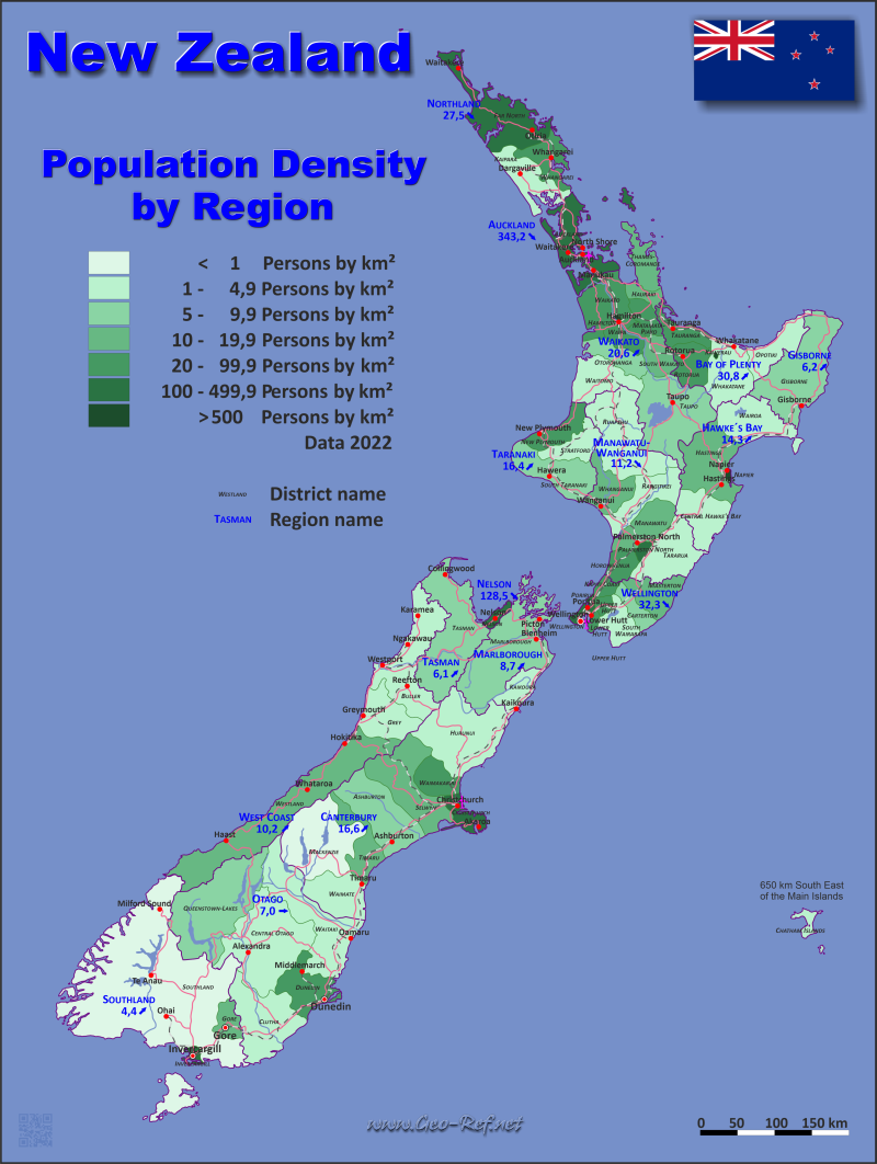
New Zealand map - Click the map to get map as PDF file.
Other language versions are easy to generate, the descriptions are in own layers
Conditions for thematic maps with your own data and logotype
Delivery as printable file by e-mail or plot by post office
|
|---|
| Layers | |
| Provinces: | yes |
| Streets: | yes |
| Infrastructure: | yes |
| Rivers: | yes |
|
| Size | Till A2 |
| Delivery time | 7 working days | | Price |
| 1 bis 3 | 85 € | | > 3 | On request |
|
 |
All information published herein is free usable quoting the source,
including the maps, if they are not modified
|
|---|
Statistical data - Population density according to the administrative structure
The population data of the table below is an estimation form 2022, based on the census 2018.
Click on the column header brings the table in order of the column header.
The default order is the region name.
| Region |
ISO
3166-2 |
island |
Capital |
Area
(km²) |
Population |
Density
(pers/km²) |
| Total |
|
|
|
264 974 |
5 123 960 |
19,3 |
|---|
| Last update: 12.06.2025 - 08:44:38 |
|---|
| Auckland |
NZ-AUK |
North |
Auckland |
4 940 |
1 695 200 |
343,2 |
| Bay of Plenty |
NZ-BOP |
North |
Whakatane |
12 058 |
351 360 |
29,1 |
| Canterbury |
NZ-CAN |
South |
Christchurch |
39 058 |
649 580 |
16,6 |
| Gisborne |
NZ-GIS |
North |
Gisborne |
8 386 |
52 100 |
6,2 |
| Hawke´s Bay |
NZ-HKB |
North |
Napier |
12 741 |
182 540 |
14,3 |
| Manawatu-Wanganui |
NZ-MWT |
North |
Palmerston North |
22 071 |
258 150 |
11,7 |
| Marlborough |
NZ-MBH |
South |
Blenheim |
12 505 |
56 060 |
4,5 |
| Nelson |
NZ-NSN |
South |
Nelson |
424 |
54 500 |
128,5 |
| Northland |
NZ-NTL |
North |
Whangarei |
12 508 |
201 500 |
16,1 |
| Otago |
NZ-OTA |
South |
Dunedin |
35 405 |
248 050 |
7,0 |
| Southland |
NZ-STL |
South |
Invercargill |
31 195 |
81 550 |
2,6 |
| Taranaki |
NZ-TKI |
North |
Stratford |
7 943 |
130 450 |
16,4 |
| Tasman |
NZ-TAS |
South |
Richmond |
9 616 |
58 700 |
6,1 |
| Walkato |
NZ-WKO |
North |
Hamilton |
24 901 |
513 820 |
20,6 |
| Wellingotn |
NZ-WGN |
North |
Wellington |
7 979 |
557 650 |
69,9 |
| West Coast |
NZ-WTC |
South |
Greymouth |
23 244 |
32 750 |
1,4 |
In addition to the regional structure Zealand is divided into districts. The following table illustrates this structure.
| District |
HASC |
region |
Capital
| Area
(km²) |
Population |
Density
(pers/km²) |
| Total |
|
|
|
264 974 |
5 123 960 |
19,3 |
|---|
| Last update: 12.06.2025 - 08:44:38 |
|---|
| Ashburton |
CA-AB |
Canterbury |
Canterbury |
6 183 |
36 300 |
5,9 |
| Auckland |
AU-AL |
Auckland |
Auckland |
4 940 |
1 695 200 |
343,2 |
| Bay of Plenty |
BP-WB |
Bay of Plenty |
Greerton |
1 951 |
59 700 |
30,6 |
| Buller |
WC-BU |
West Coast |
Westport |
7 942 |
9 730 |
1,2 |
| Carterton |
WG-CR |
Wellingotn |
Carterton |
1 180 |
10 250 |
8,7 |
| Central Hawke´s Bay |
HB-CH |
Hawke´s Bay |
Waipawa |
3 332 |
15 950 |
4,8 |
| Central Otago |
OT-CO |
Otago |
Alexandra |
9 956 |
25 500 |
2,6 |
| Chatham Islands |
CI-CT |
Canterbury |
Waitangi |
794 |
800 |
1,0 |
| Christchurch City |
CA-CC |
Canterbury |
Christchurch |
1 415 |
389 300 |
275,1 |
| Clutha |
OT-CL |
Otago |
Balclutha |
6 334 |
18 650 |
2,9 |
| Dunedin City |
OT-DU |
Otago |
Dunedin |
3 287 |
130 400 |
39,7 |
| Far North |
NO-FN |
Northland |
Kaikohe |
6 687 |
73 800 |
11,0 |
| Gisborne |
GI-GB |
Gisborne |
Gisborne |
8 386 |
52 100 |
6,2 |
| Gore |
SO-GO |
Southland |
Gore |
1 254 |
13 000 |
10,4 |
| Grey |
WC-GR |
West Coast |
Greymouth |
3 474 |
14 200 |
4,1 |
| Hamilton City |
WK-HM |
Walkato |
Hamilton |
110 |
179 900 |
1 635,5 |
| Hastings |
HB-HS |
Hawke´s Bay |
Hastings |
5 227 |
90 600 |
17,3 |
| Hauraki |
WK-HK |
Walkato |
Paeroa |
1 270 |
22 200 |
17,5 |
| Horowhenua |
MW-HW |
Manawatu-Wanganui |
Levin |
1 064 |
37 000 |
34,8 |
| Hurunui |
CA-HN |
Canterbury |
Amberley |
8 641 |
13 700 |
1,6 |
| Invercargill City |
SO-IC |
Southland |
Invercargill |
389 |
56 800 |
146,0 |
| Kaikoura |
CA-KK |
Marlborough |
Kaikoura |
2 047 |
4 160 |
2,0 |
| Kaipara |
NO-KP |
Northland |
Dargaville |
3 109 |
27 200 |
8,7 |
| Kapiti Coast |
WG-KC |
Wellingotn |
Paraparaumu |
731 |
57 600 |
78,8 |
| Kawerau |
BP-KW |
Bay of Plenty |
Kawerau |
24 |
7 760 |
323,3 |
| Lower Hutt City |
WG-LH |
Wellingotn |
Lower Hutt |
376 |
112 500 |
299,2 |
| Mackenzie |
CA-MZ |
Canterbury |
Fairlie |
7 140 |
5 460 |
0,8 |
| Manawatu |
MW-MN |
Manawatu-Wanganui |
Feilding |
2 657 |
33 900 |
12,8 |
| Marlborough |
MA-MB |
Marlborough |
Blenheim |
10 458 |
51 900 |
5,0 |
| Masterton |
WG-MT |
Wellingotn |
Masterton |
2 300 |
29 000 |
12,6 |
| Matamata-Piako |
WK-MP |
Walkato |
Te Aroha |
1 755 |
37 100 |
21,1 |
| Napier City |
HB-NR |
Hawke´s Bay |
Napier |
105 |
66 800 |
636,2 |
| Nelson City |
NE-NL |
Nelson |
Nelson |
424 |
54 500 |
128,5 |
| New Plymouth |
TK-NP |
Taranaki |
New Plymouth |
2 205 |
87 700 |
39,8 |
| Opotiki |
BP-OP |
Bay of Plenty |
Opotiki |
3 089 |
10 500 |
3,4 |
| Otorohanga |
WK-OH |
Walkato |
Otorohanga |
1 999 |
10 850 |
5,4 |
| Palmerston North City |
MW-PN |
Manawatu-Wanganui |
Palmerston North |
395 |
90 400 |
228,9 |
| Porirua City |
WG-PR |
Wellingotn |
Porirua |
175 |
61 600 |
352,0 |
| Queenstown-Lakes |
OT-QL |
Otago |
Queenstown |
8 719 |
49 500 |
5,7 |
| Rangitikei |
MW-RT |
Manawatu-Wanganui |
Marton |
4 484 |
16 100 |
3,6 |
| Rotorua |
WK-RR |
Bay of Plenty |
Rotorua |
2 409 |
76 800 |
31,9 |
| Ruapehu |
MW-RP |
Manawatu-Wanganui |
Taumarunui |
6 734 |
13 000 |
1,9 |
| Selwyn |
CA-SY |
Canterbury |
Rolleston |
6 381 |
79 300 |
12,4 |
| South Taranaki |
TK-ST |
Taranaki |
Hawera |
3 575 |
32 600 |
9,1 |
| South Waikato |
WK-SW |
Walkato |
Tokoroa |
1 819 |
29 600 |
16,3 |
| South Wairarapa |
WG-SP |
Wellingotn |
Martinborough |
2 387 |
25 900 |
10,9 |
| Southland |
SO-SL |
Southland |
Invercargill |
29 552 |
11 750 |
0,4 |
| Stratford |
TK-SF |
Taranaki |
Stratford |
2 163 |
10 150 |
4,7 |
| Tararua |
MW-TR |
Manawatu-Wanganui |
Dannevirke |
4 364 |
19 050 |
4,4 |
| Tasman |
TS-TM |
Tasman |
Richmond |
9 616 |
58 700 |
6,1 |
| Taupo |
WK-TP |
Walkato |
Taupo |
6 333 |
41 400 |
6,5 |
| Tauranga City |
BP-TG |
Bay of Plenty |
Tauranga |
135 |
158 300 |
1 172,6 |
| Thames-Coromandel |
WK-TC |
Walkato |
Thames |
2 207 |
33 700 |
15,3 |
| Timaru |
CA-TU |
Canterbury |
Timaru |
2 733 |
48 500 |
17,7 |
| Upper Hutt City |
WG-UH |
Wellingotn |
Upper Hutt |
540 |
47 700 |
88,3 |
| Waikato |
WK-WT |
Walkato |
Ngaruawahia |
4 403 |
88 900 |
20,2 |
| Waimakariri |
CA-WR |
Canterbury |
Rangiora |
2 217 |
67 900 |
30,6 |
| Waimate |
CA-WM |
Canterbury |
Waimate |
3 554 |
8 320 |
2,3 |
| Waipa |
WK-WP |
Walkato |
Te Awamutu |
1 470 |
60 500 |
41,2 |
| Wairoa |
HB-WW |
Hawke´s Bay |
Wairoa |
4 077 |
9 190 |
2,3 |
| Waitaki |
OT-WI |
Otago |
Oamaru |
7 109 |
24 000 |
3,4 |
| Waitomo |
WK-WO |
Walkato |
Te Kuiti |
3 535 |
9 670 |
2,7 |
| Wellington City |
WG-WE |
Wellingotn |
Wellington |
290 |
213 100 |
734,8 |
| Westland |
WC-WL |
West Coast |
Hokitika |
11 828 |
8 820 |
0,7 |
| Whakatane |
BP-WH |
Bay of Plenty |
Whakatane |
4 450 |
38 300 |
8,6 |
| Whanganui |
MW-WU |
Manawatu-Wanganui |
Whanganui |
2 373 |
48 700 |
20,5 |
| Whangarei |
NO-WN |
Northland |
Whangarei |
2 712 |
100 500 |
37,1 |
Existing thematic maps
|
External links change quickly - If you get a link error - Please inform us!
 |
Membership in international organisations and treaties
Expand list
Political Alliances
Regional Unions
Military alliances/Arms control
Law enforcement
Business Alliances
Fishery
Financial
Free Trade Area, Internal Market
Technical alliances
Environment
Transport
Cientific
Humanitarian Unions
Cultural Unions
|
|
If you have suggestions to include other information or you find missed links, please inform us!
Click here ... |
See also neighboring states
|


