French Republic
| Capital |
Currency | Government system |
|---|
| Paris |
Euro (EUR) |
Presidential system |
| Official language | Region |
Population |
|---|
| French |
Europe |
Estimation 2025
66 351 959 |
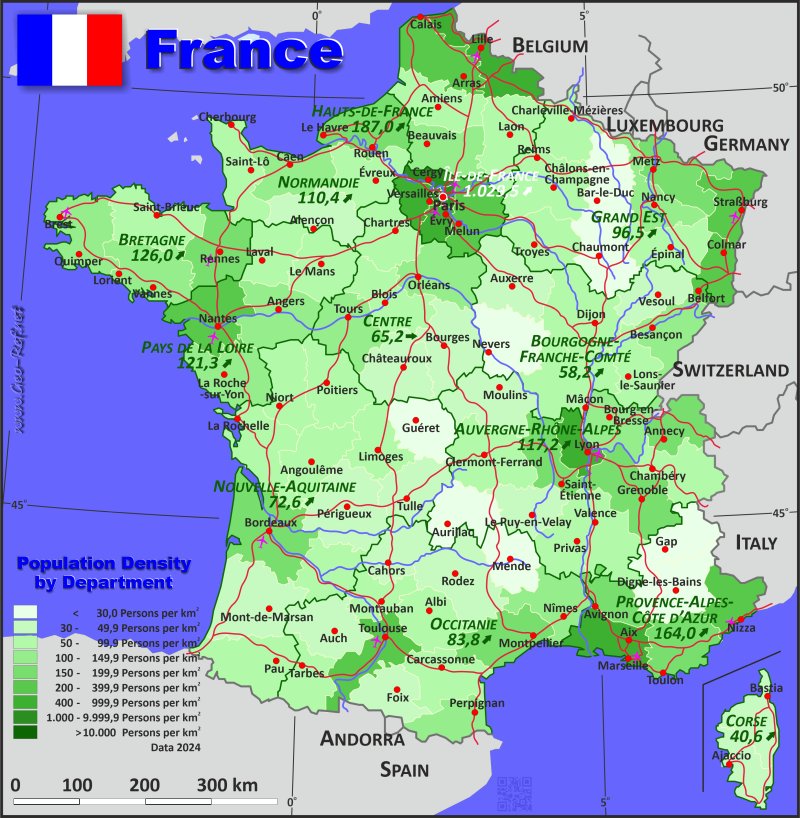
Country map - Administrative structure - Population density of France
France map - Click the map to get map as PDF file.
Other language versions are easy to generate, the descriptions are in own layers
Conditions for thematic maps with your own data and logotype
Delivery as printable file by e-mail or plot by post office
|
|---|
| Layers | |
| Provinces: | yes |
| Streets: | yes |
| Infrastructure: | yes |
| Rivers: | yes |
|
| Size | Till A2 |
| Delivery time | 7 working days | | Price |
| 1 bis 3 | 100 € - Departments
60 € - Region | | > 3 | On request |
|
 |
All information published herein is free usable quoting the source,
including the maps, if they are not modified
|
|---|
Statistical data - Population density according to the administrative structure
The population data of the table below is an estimation form 2025, based on the census 2014.
Administrative Division by Region
Click on the column header brings the table in order of the column header.
The default order is the region name.
| Region |
ISO
3166-2 |
Capital |
Area
(km²) |
Population |
Density
(pers/km²) |
| Total |
|
|
547 993,2 |
66 351 959 |
121,1 |
|---|
| Last update: 01/02/2026 - 19:45:59 |
|---|
| Auvergne-Rhône-Alpes |
FR-ARA |
Lyon |
70 257,8 |
8 260 096,0 |
117,6 |
| Bourgogne-Franche-Comté |
FR-BFC |
Dijon |
47 963,2 |
2 793 080,0 |
58,2 |
| Bretagne |
FR-BRE |
Rennes |
27 407,8 |
3 475 895,0 |
126,8 |
| Centre-Val de Loire |
FR-CVL |
Orléans |
39 469,8 |
2 581 479,0 |
65,4 |
| Corse |
FR-COR |
Ajaccio |
8 759,8 |
360 162,0 |
41,1 |
| Grand Est |
FR-GES |
Strasbourg |
57 705,0 |
5 544 051,0 |
96,1 |
| Hauts-de-France |
FR-HDF |
Lille |
32 002,2 |
5 973 933,0 |
186,7 |
| Île-de-France |
FR-IDF |
Paris |
12 064,6 |
12 450 849,0 |
1 032,0 |
| Normandie |
FR-NOR |
Rouen |
30 149,2 |
3 341 312,0 |
110,8 |
| Nouvelle-Aquitaine |
FR-NAQ |
Bordeaux |
84 749,2 |
6 191 209,0 |
73,1 |
| Occitanie |
FR-OCC |
Toulouse |
73 412,3 |
6 201 587,0 |
84,5 |
| Pays de la Loire |
FR-PDL |
Nantes |
32 363,6 |
3 936 719,0 |
121,6 |
| Provence-Alpes-Côte d’Azur |
FR-PAC |
Marseille |
31 688,7 |
5 241 587,0 |
165,4 |
Administrative Division by Departments
| Department |
ISO
3166-2 |
Region |
Capital
| Area
(km²) |
Population |
Density
(pers/km²) |
| Total |
|
|
|
547 993,2 |
66 351 959 |
121,1 |
|---|
| Last update: 01/02/2026 - 19:45:59 |
|---|
| Ain |
FR-01 |
Auvergne - Rhône - Alpes |
Bourg-en-Bresse |
5 778,5 |
688 626 |
119,2 |
| Aisne |
FR-02 |
Hauts-de-France |
Laon |
7 418,4 |
518 817 |
69,9 |
| Allier |
FR-03 |
Auvergne - Rhône - Alpes |
Moulins |
7 365,3 |
332 599 |
45,2 |
| Alpes-de-Haute-Provence |
FR-04 |
Provence - Alpes - Côte d'Azur |
Digne-les-Bains |
6 994,1 |
169 806 |
24,3 |
| Alpes-Maritimes |
FR-06 |
Provence - Alpes - Côte d'Azur |
Nice |
4 295,0 |
1 129 950 |
263,1 |
| Ardèche |
FR-07 |
Auvergne - Rhône - Alpes |
Privas |
5 560,5 |
336 947 |
60,6 |
| Ardennes |
FR-08 |
Grand Est |
Charleville-Mézières |
5 250,3 |
263 194 |
50,1 |
| Ariège |
FR-09 |
Occitanie |
Foix |
4 921,5 |
156 787 |
31,9 |
| Aube |
FR-10 |
Grand Est |
Troyes |
6 022,3 |
310 930 |
51,6 |
| Aude |
FR-11 |
Occitanie |
Carcassonne |
6 354,6 |
379 729 |
59,8 |
| Aveyron |
FR-12 |
Occitanie |
Rodez |
8 770,1 |
278 355 |
31,7 |
| Bas-Rhin |
FR-67 |
Grand Est |
Strasbourg |
4 795,5 |
1 168 669 |
243,7 |
| Bouches-du-Rhône |
FR-13 |
Provence - Alpes - Côte d'Azur |
Marseille |
5 098,2 |
2 090 225 |
410,0 |
| Calvados |
FR-14 |
Normandie |
Caen |
5 592,2 |
711 029 |
127,1 |
| Cantal |
FR-15 |
Auvergne - Rhône - Alpes |
Aurillac |
5 767,2 |
143 746 |
24,9 |
| Charente |
FR-16 |
Nouvelle-Aquitaine |
Angoulême |
5 964,0 |
350 209 |
58,7 |
| Charente-Maritime |
FR-17 |
Nouvelle-Aquitaine |
La Rochelle |
6 898,6 |
681 666 |
98,8 |
| Cher |
FR-18 |
Centre - Val de Loire |
Bourges |
7 293,0 |
295 830 |
40,6 |
| Corrèze |
FR-19 |
Nouvelle-Aquitaine |
Tulle |
5 889,8 |
239 483 |
40,7 |
| Corse-du-Sud |
FR-2A |
Corse [Korsika] |
Ajaccio |
4 037,5 |
172 719 |
42,8 |
| Côte-d'Or |
FR-21 |
Bourgogne - Franche-Comté [Burgund] |
Dijon |
8 787,5 |
538 799 |
61,3 |
| Côtes-d'Armor |
FR-22 |
Bretagne |
Saint-Brieuc |
6 982,9 |
615 301 |
88,1 |
| Creuse |
FR-23 |
Nouvelle-Aquitaine |
Guéret |
5 589,6 |
114 103 |
20,4 |
| Deux-Sèvres |
FR-79 |
Nouvelle-Aquitaine |
Niort |
6 028,9 |
374 315 |
62,1 |
| Dordogne |
FR-24 |
Nouvelle-Aquitaine |
Périgueux |
9 204,7 |
417 714 |
45,4 |
| Doubs |
FR-25 |
Bourgogne - Franche-Comté [Burgund] |
Besançon |
5 237,4 |
550 846 |
105,2 |
| Drôme |
FR-26 |
Auvergne - Rhône - Alpes |
Valence |
6 553,8 |
524 409 |
80,0 |
| Essonne |
FR-91 |
Île-de-France |
Évry |
1 818,5 |
1 343 527 |
738,8 |
| Eure |
FR-27 |
Normandie |
Évreux |
6 034,4 |
601 942 |
99,8 |
| Eure-et-Loir |
FR-28 |
Centre - Val de Loire |
Chartres |
5 927,3 |
433 148 |
73,1 |
| Finistère |
FR-29 |
Bretagne |
Quimper |
6 760,4 |
936 238 |
138,5 |
| Gard |
FR-30 |
Occitanie |
Nîmes |
5 875,4 |
775 994 |
132,1 |
| Gers |
FR-32 |
Occitanie |
Auch |
6 303,6 |
193 053 |
30,6 |
| Gironde |
FR-33 |
Nouvelle-Aquitaine |
Bordeaux |
10 168,6 |
1 718 654 |
169,0 |
| Haute-Corse |
FR-2B |
Corse [Korsika] |
Bastia |
4 722,3 |
187 443 |
39,7 |
| Haute-Garonne |
FR-31 |
Occitanie |
Toulouse |
6365,1 |
1 506 391 |
236,7 |
| Haute-Loire |
FR-43 |
Auvergne - Rhône - Alpes |
Le Puy-en-Velay |
4 997,7 |
227 959 |
45,6 |
| Haute-Marne |
FR-52 |
Grand Est |
Chaumont |
6 249,9 |
167 047 |
26,7 |
| Hautes-Alpes |
FR-05 |
Provence - Alpes - Côte d'Azur |
Gap |
5 685,6 |
142 006 |
25,0 |
| Haute-Saône |
FR-70 |
Bourgogne - Franche-Comté [Burgund] |
Vesoul |
5 382,3 |
231 932 |
43,1 |
| Haute-Savoie |
FR-74 |
Auvergne - Rhône - Alpes |
Annecy |
4 591,9 |
870 588 |
189,6 |
| Hautes-Pyrénées |
FR-65 |
Occitanie |
Tarbes |
4 528,8 |
232 548 |
51,3 |
| Haute-Vienne |
FR-87 |
Nouvelle-Aquitaine |
Limoges |
5 547,4 |
371 297 |
66,9 |
| Haut-Rhin |
FR-68 |
Grand Est |
Colmar |
3 527,4 |
765 827 |
217,1 |
| Hauts-de-Seine |
FR-92 |
Île-de-France |
Nanterre |
175,6 |
1 663 974 |
9 475,9 |
| Hérault |
FR-34 |
Occitanie |
Montpellier |
6 234,5 |
1 252 904 |
201,0 |
| Ille-et-Vilaine |
FR-35 |
Bretagne |
Rennes |
6 832,0 |
1 134 891 |
166,1 |
| Indre |
FR-36 |
Centre - Val de Loire |
Châteauroux |
6 886,6 |
213 358 |
31,0 |
| Indre-et-Loire |
FR-37 |
Centre - Val de Loire |
Tours |
6 146,9 |
620 686 |
101,0 |
| Isère |
FR-38 |
Auvergne - Rhône - Alpes |
Grenoble |
7 868,2 |
1 308 807 |
166,3 |
| Jura |
FR-39 |
Bourgogne - Franche-Comté [Burgund] |
Lons-le-Saunier |
5 032,8 |
256 977 |
51,1 |
| Landes |
FR-40 |
Nouvelle-Aquitaine |
Mont-de-Marsan |
9 352,7 |
440 763 |
47,1 |
| Loire |
FR-42 |
Auvergne - Rhône - Alpes |
Saint-Étienne |
4 796,4 |
776 590 |
161,9 |
| Loire-Atlantique |
FR-44 |
Pays de la Loire |
Nantes |
6 996,9 |
1 510 913 |
215,9 |
| Loiret |
FR-45 |
Centre - Val de Loire |
Orléans |
6 804,2 |
691 006 |
101,6 |
| Loir-et-Cher |
FR-41 |
Centre - Val de Loire |
Blois |
6 411,8 |
327 451 |
51,1 |
| Lot |
FR-46 |
Occitanie |
Cahors |
5 221,9 |
176 432 |
33,8 |
| Lot-et-Garonne |
FR-47 |
Nouvelle-Aquitaine |
Agen |
5 382,6 |
332 372 |
61,7 |
| Lozère |
FR-48 |
Occitanie |
Mende |
5 172,1 |
76 452 |
14,8 |
| Maine-et-Loire |
FR-49 |
Pays de la Loire |
Angers |
7 160,2 |
835 364 |
116,7 |
| Manche |
FR-50 |
Normandie |
Saint-Lô |
6 018,5 |
496 199 |
82,4 |
| Marne |
FR-51 |
Grand Est |
Châlons-en-Champagne |
8 196,6 |
558 743 |
68,2 |
| Mayenne |
FR-53 |
Pays de la Loire |
Laval |
5 207,9 |
303 245 |
58,2 |
| Meurthe-et-Moselle |
FR-54 |
Grand Est |
Nancy |
5 283,5 |
729 358 |
138,0 |
| Meuse |
FR-55 |
Grand Est |
Bar-le-Duc |
6 234,6 |
177 024 |
28,4 |
| Morbihan |
FR-56 |
Bretagne |
Vannes |
6 832,5 |
789 465 |
115,5 |
| Moselle |
FR-57 |
Grand Est |
Metz |
6 253,5 |
1 050 955 |
168,1 |
| Nièvre |
FR-58 |
Bourgogne - Franche-Comté [Burgund] |
Nevers |
6 863,2 |
199 666 |
29,1 |
| Nord |
FR-59 |
Hauts-de-France |
Lille |
5 767,7 |
2 615 505 |
453,5 |
| Oise |
FR-60 |
Hauts-de-France |
Beauvais |
5 894,3 |
829 583 |
140,7 |
| Orne |
FR-61 |
Normandie |
Alençon |
6 177,2 |
271 896 |
44,0 |
| Paris |
FR-75C |
Île-de-France |
Paris |
105,3 |
2 048 472 |
19 453,7 |
| Pas-de-Calais |
FR-62 |
Hauts-de-France |
Arras |
6 715,0 |
1 450 306 |
216,0 |
| Puy-de-Dôme |
FR-63 |
Auvergne - Rhône - Alpes |
Clermont-Ferrand |
8 001,5 |
664 068 |
83,0 |
| Pyrénées-Atlantiques |
FR-64 |
Nouvelle-Aquitaine |
Pau |
7 696,4 |
713 482 |
92,7 |
| Pyrénées-Orientales |
FR-66 |
Occitanie |
Perpignan |
4 150,4 |
503 866 |
121,4 |
| Rhône |
FR-69 |
Auvergne - Rhône - Alpes |
Lyon |
2 715,5 |
1 932 598 |
711,7 |
| Saône-et-Loire |
FR-71 |
Bourgogne - Franche-Comté [Burgund] |
Mâcon |
8 598,5 |
545 310 |
63,4 |
| Sarthe |
FR-72 |
Pays de la Loire |
Le Mans |
6 238,0 |
564 160 |
90,4 |
| Savoie |
FR-73 |
Auvergne - Rhône - Alpes |
Chambéry |
6 261,3 |
453 159 |
72,4 |
| Seine-et-Marne |
FR-77 |
Île-de-France |
Melun |
5 924,1 |
1 479 615 |
249,8 |
| Seine-Maritime |
FR-76 |
Normandie |
Rouen |
6 326,9 |
1 260 246 |
199,2 |
| Seine-Saint-Denis |
FR-93 |
Île-de-France |
Bobigny |
236,8 |
1 711 876 |
7 229,2 |
| Somme |
FR-80 |
Hauts-de-France |
Amiens |
6 206,8 |
559 722 |
90,2 |
| Tarn |
FR-81 |
Occitanie |
Albi |
5 784,1 |
401 283 |
69,4 |
| Tarn-et-Garonne |
FR-82 |
Occitanie |
Montauban |
3 730,2 |
267 793 |
71,8 |
| Territoire de Belfort |
FR-90 |
Bourgogne - Franche-Comté [Burgund] |
Belfort |
610,3 |
138 419 |
226,8 |
| Val-de-Marne |
FR-94 |
Île-de-France |
Créteil |
244,9 |
1 426 433 |
5 824,6 |
| Val-d'Oise |
FR-95 |
Île-de-France |
Pontoise / Cergy |
1 253,2 |
1 287 589 |
1 027,4 |
| Var |
FR-83 |
Provence - Alpes - Côte d'Azur |
Toulon |
6 037,7 |
1 135 917 |
188,1 |
| Vaucluse |
FR-84 |
Provence - Alpes - Côte d'Azur |
Avignon |
3 578,1 |
573 683 |
160,3 |
| Vendée |
FR-85 |
Pays de la Loire |
La Roche-sur-Yon |
6 760,6 |
723 037 |
106,9 |
| Vienne |
FR-86 |
Nouvelle-Aquitaine |
Poitiers |
7 025,9 |
437 151 |
62,2 |
| Vosges |
FR-88 |
Grand Est |
Épinal |
5 891,4 |
352 304 |
59,8 |
| Yonne |
FR-89 |
Bourgogne - Franche-Comté [Burgund] |
Auxerre |
7 451,2 |
331 131 |
44,4 |
| Yvelines |
FR-78 |
Île-de-France |
Versailles |
2 306,2 |
1 489 363 |
645,8 |
Existing thematic maps
|
External links change quickly - If you get a link error - Please inform us!
 |
Membership in international organisations and treaties
Expand list
Political Alliances
Regional Unions
Military alliances/Arms control
Law enforcement
Business Alliances
Fishery
Financial
Free Trade Area, Internal Market
Technical alliances
Environment
Transport
Cientific
Humanitarian Unions
Cultural Unions
|
|
If you have suggestions to include other information or you find missed links, please inform us!
Click here ... |
International Border disputes
Expand list
Land boundaries
Maritime boundaries
See also neighboring states
|
| |


