Japan
| Capital |
Currency | Government system |
|---|
| Tokyo |
Yen (JPY) |
Parliamentary democracy |
| Official language | Region |
Population |
|---|
| Japanese |
Far East |
Estimation 2020
126 146 099 |
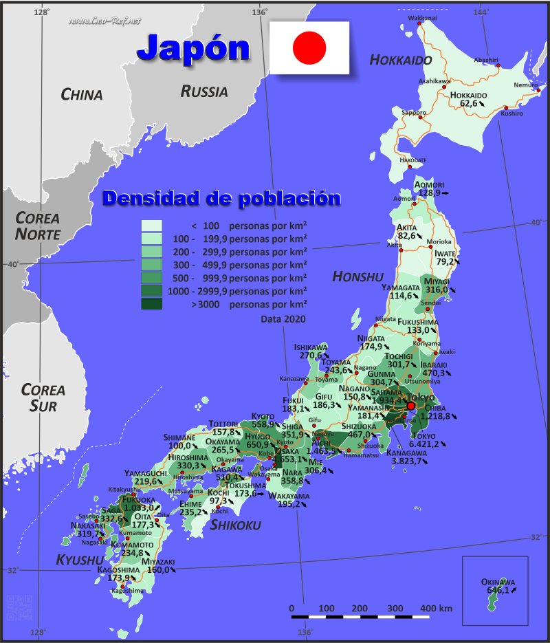
Country map - Administrative structure - Population density of Japan
Japan map - Click the map to get map as PDF file.
Other language versions are easy to generate, the descriptions are in own layers
Conditions for thematic maps with your own data and logotype
Delivery as printable file by e-mail or plot by post office
|
|---|
| Layers | |
| Provinces: | yes |
| Streets: | yes |
| Infrastructure: | yes |
| Rivers: | yes |
|
| Size | Till A2 |
| Delivery time | 7 working days | | Price |
| 1 bis 3 | 85 € | | > 3 | On request |
|
 |
All information published herein is free usable quoting the source,
including the maps, if they are not modified
|
|---|
Statistical data - Population density according to the administrative structure
The population data of the table below is an estimation form 2020, based on the census 2017.
Click on the column header brings the table in order of the column header.
The default order is the prefecture name.
| Prefecture |
ISO
3166-2 |
region |
Capital |
Area
(km²) |
Population |
Density
(pers/km²) |
| Total |
|
|
|
376 745 |
126 146 099 |
334,8 |
|---|
| Last update: 12.06.2025 - 08:44:38 |
|---|
| Aichi |
JP-23 |
Chubu |
Nagoya |
5 153,8 |
7 542 415 |
1 463,5 |
| Akita |
JP-05 |
Tohoku |
Akita (city) |
11 612,2 |
959 502 |
82,6 |
| Aomori |
JP-02 |
Tohoku |
Aomori (city) |
9 606,3 |
1 237 984 |
128,9 |
| Chiba |
JP-12 |
Kanto |
Chiba |
5 156,2 |
6 284 480 |
1 218,8 |
| Ehime |
JP-38 |
Shikoku |
Matsuyama |
5 676,4 |
1 334 841 |
235,2 |
| Fukui |
JP-18 |
Chubu |
Fukui |
4 189,0 |
766 863 |
183,1 |
| Fukuoka |
JP-40 |
Kyushu |
Fukuoka |
4 971,0 |
5 135 214 |
1 033,0 |
| Fukushima |
JP-07 |
Tohoku |
Fukushima (city) |
13 782,5 |
1 833 152 |
133,0 |
| Gifu |
JP-21 |
Chubu |
Gifu |
10 621,2 |
1 978 742 |
186,3 |
| Gunma |
JP-10 |
Kanto |
Maebashi |
6 363,2 |
1 939 110 |
304,7 |
| Hiroshima |
JP-34 |
Chugoku |
Hiroshima |
8 477,0 |
2 799 702 |
330,3 |
| Hokkaido |
JP-01 |
Hokkaido |
Sapporo |
83 453,6 |
5 224 614 |
62,6 |
| Hyogo |
JP-28 |
Kansai |
Kobe |
8 396,1 |
5 465 002 |
650,9 |
| Ibaraki |
JP-08 |
Kanto |
Mito |
6 095,6 |
2 867 009 |
470,3 |
| Ishikawa |
JP-17 |
Chubu, Hokuriku |
Kanazawa |
4 185,2 |
1 132 526 |
270,6 |
| Iwate |
JP-03 |
Tohoku |
Morioka |
15 278,4 |
1 210 534 |
79,2 |
| Kagawa |
JP-37 |
Shikoku |
Takamatsu |
1 861,7 |
950 244 |
510,4 |
| Kagoshima |
JP-46 |
Kyushu |
Kagoshima |
9 132,4 |
1 588 256 |
173,9 |
| Kanagawa |
JP-14 |
Kanto |
Yokohama |
2 415,8 |
9 237 337 |
3 823,7 |
| Kochi |
JP-39 |
Shikoku |
Kochi |
7 104,9 |
691 527 |
97,3 |
| Kumamoto |
JP-43 |
Kyushu |
Kumamoto |
7 404,1 |
1 738 301 |
234,8 |
| Kyoto |
JP-26 |
Kansai |
Kyoto |
4 612,7 |
2 578 087 |
558,9 |
| Mie |
JP-24 |
Kansai |
Tsu |
5 777,2 |
1 770 254 |
306,4 |
| Miyagi |
JP-04 |
Tohoku |
Sendai |
7 285,2 |
2 301 996 |
316,0 |
| Miyazaki |
JP-45 |
Kyushu |
Miyazaki |
6 684,7 |
1 069 576 |
160,0 |
| Nagano |
JP-20 |
Chubu |
Nagano |
13 585,2 |
2 048 011 |
150,8 |
| Nagasaki |
JP-42 |
Kyushu |
Nagasaki |
4 104,5 |
1 312 317 |
319,7 |
| Nara |
JP-29 |
Kansai |
Nara |
3 691,1 |
1 324 473 |
358,8 |
| Niigata |
JP-15 |
Chubu, Hokuriku |
Niigata |
12 582,5 |
2 201 272 |
174,9 |
| Oita |
JP-44 |
Kyushu |
oita |
6 338,8 |
1 123 852 |
177,3 |
| Okayama |
JP-33 |
Chugoku |
Okayama (city) |
7 113,3 |
1 888 432 |
265,5 |
| Okinawa |
JP-47 |
Kyushu |
Naha |
2 271,3 |
1 467 480 |
646,1 |
| Osaka |
JP-27 |
Kansai |
Osaka |
1 899,3 |
8 837 685 |
4 653,1 |
| Saga |
JP-41 |
Kyushu |
Saga |
2 439,6 |
811 442 |
332,6 |
| Saitama |
JP-11 |
Kanto |
Saitama |
3 797,0 |
7 344 765 |
1 934,4 |
| Shiga |
JP-25 |
Kansai |
otsu |
4 017,4 |
1 413 610 |
351,9 |
| Shimane |
JP-32 |
Chugoku |
Matsue |
6 708,0 |
671 126 |
100,0 |
| Shizuoka |
JP-22 |
Chubu |
Shizuoka City |
7 779,6 |
3 633 202 |
467,0 |
| Tochigi |
JP-09 |
Kanto |
Utsunomiya |
6 408,3 |
1 933 146 |
301,7 |
| Tokushima |
JP-36 |
Shikoku |
Tokushima (city) |
4 145,0 |
719 559 |
173,6 |
| Tokyo |
JP-13 |
Kanto |
Tokyo |
2 187,7 |
14 047 594 |
6 421,2 |
| Tottori |
JP-31 |
Chugoku |
Tottori (city) |
3 507,2 |
553 407 |
157,8 |
| Toyama |
JP-16 |
Chubu, Hokuriku |
Toyama City |
4 247,2 |
1 034 814 |
243,6 |
| Wakayama |
JP-30 |
Kansai |
Wakayama |
4 725,7 |
922 584 |
195,2 |
| Yamagata |
JP-06 |
Tohoku |
Yamagata |
9 323,3 |
1 068 027 |
114,6 |
| Yamaguchi |
JP-35 |
Chugoku |
Yamaguchi |
6 110,9 |
1 342 059 |
219,6 |
| Yamanashi |
JP-19 |
Chubu |
Kofu |
4 465,4 |
809 974 |
181,4 |
Existing thematic maps
|
External links change quickly - If you get a link error - Please inform us!
 |
Membership in international organisations and treaties
Expand list
Political Alliances
Regional Unions
Military alliances/Arms control
Law enforcement
Business Alliances
Fishery
Financial
Free Trade Area, Internal Market
Technical alliances
Environment
Transport
Cientific
Humanitarian Unions
Cultural Unions
|
|
If you have suggestions to include other information or you find missed links, please inform us!
Click here ... |
International Border disputes
Expand list
See also neighboring states
|
| |


