Guadeloupe
| Capital |
Currency | Government system |
|---|
| Basse-Terre |
Euro (EUR) |
Dependent from France |
| Official language | Region |
Population |
|---|
| French |
Central America & Caribbean |
Estimation 2021
384 315 |
Country map - Administrative structure - Population density of Guadeloupe
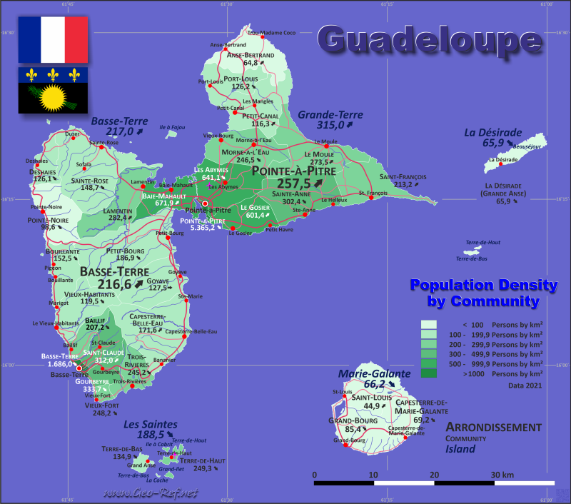
Guadeloupe map - Click the map to get map as PDF file.
Other language versions are easy to generate, the descriptions are in own layers
Conditions for thematic maps with your own data and logotype
Delivery as printable file by e-mail or plot by post office
|
|---|
| Layers | |
| Provinces: | yes |
| Streets: | yes |
| Infrastructure: | yes |
| Rivers: | yes |
|
| Size | Till A2 |
| Delivery time | 7 working days | | Price |
| 1 bis 3 | 65 € | | > 3 | On request |
|
 |
All information published herein is free usable quoting the source,
including the maps, if they are not modified
|
|---|
Statistical data - Population density according to the administrative structure
The population data of the table below is an estimation form 2021, last available data.
Guadeloupe consists of 5 islands and archipelagos, illustrated in the first table - divided into 2 arrondissements - these are shown in the second table, the communities are assigned to them.
Click on the column header brings the table in order of the column header.
The default order is the island name.
| Island |
INSEE |
Capital |
Area
(km²) |
Population |
Density
(pers/km²) |
| Total |
|
|
1 628,4 |
384 315 |
236,0 |
|---|
| Last update: 05.06.2025 - 00:37:41 |
|---|
| Basse-Terre |
BT |
Basse-Terre |
841,5 |
182 599 |
217,0 |
| Grande-Terre |
GT |
Pointe-à-Pitre |
595,0 |
187 445 |
315,0 |
| Îles des Saintes |
IS |
Terre-de-Bas |
12,8 |
2 413 |
188,5 |
| La Désirade |
LD |
La Désirade |
21,1 |
1 391 |
65,9 |
| Marie-Galante |
MG |
Grand-Bourg |
158,0 |
10 467 |
66,2 |
Die Arrondissements sind in Gemeinden aufgeteilt, die in der nächsten Tabelle dargestellt sind. Anstelle der nicht vorhandenen ISO 3166-2-Klassifizierung wird die französische INSEE-Kodifizierung verwendet.
| Community |
INSEE |
Arrondissement |
Insel |
Capital
| Area
(km²) |
Population |
Density
(pers/km²) |
| Total |
|
|
|
|
1 628,4 |
384 315 |
236,0 |
|---|
| Last update: 05.06.2025 - 00:37:41 |
|---|
| Anse-Bertrand |
97102 |
Pointe-à-Pitre |
Grande-Terre |
Anse-Bertrand |
62,5 |
4 052 |
64,8 |
| Baie-Mahault |
97103 |
Basse-Terre |
Basse-Terre |
Baie-Mahault |
46 |
30 909 |
671,9 |
| Baillif |
97104 |
Basse-Terre |
Basse-Terre |
Baillif |
24,3 |
5 035 |
207,2 |
| Basse-Terre |
97105 |
Basse-Terre |
Basse-Terre |
Basse-Terre |
5,8 |
9 779 |
1 686,0 |
| Bouillante |
97106 |
Basse-Terre |
Basse-Terre |
Bouillante |
43,5 |
6 634 |
152,5 |
| Capesterre-Belle-Eau |
97107 |
Basse-Terre |
Basse-Terre |
Capesterre-Belle-Eau |
103,3 |
17 731 |
171,6 |
| Capesterre-de-Marie-Galante |
97108 |
Pointe-à-Pitre |
Marie-Galante |
Capesterre-de-Marie-Galante |
46,2 |
3 198 |
69,2 |
| Deshaies |
97111 |
Basse-Terre |
Basse-Terre |
Deshaies |
31,1 |
3 922 |
126,1 |
| Gourbeyre |
97109 |
Basse-Terre |
Basse-Terre |
Gourbeyre |
22,5 |
7 508 |
333,7 |
| Goyave |
97114 |
Basse-Terre |
Basse-Terre |
Goyave |
59,9 |
7 638 |
127,5 |
| Grand-Bourg |
97112 |
Pointe-à-Pitre |
Marie-Galante |
Grand-Bourg |
55,5 |
4 741 |
85,4 |
| La Désirade (Grande Anse) |
97110 |
Pointe-à-Pitre |
La Désirade |
La Désirade (Grande Anse) |
21,1 |
1 391 |
65,9 |
| Lamentin |
97115 |
Basse-Terre |
Basse-Terre |
Lamentin |
65,6 |
18 527 |
282,4 |
| Le Gosier |
97113 |
Pointe-à-Pitre |
Grande-Terre |
Le Gosier |
45,2 |
27 184 |
601,4 |
| Le Moule |
97117 |
Pointe-à-Pitre |
Grande-Terre |
Le Moule |
82,8 |
22 645 |
273,5 |
| Les Abymes |
97101 |
Pointe-à-Pitre |
Grande-Terre |
Les Abymes |
81,3 |
52 118 |
641,1 |
| Morne-à-l'Eau |
97116 |
Pointe-à-Pitre |
Grande-Terre |
Morne-à-l'Eau |
64,5 |
15 898 |
246,5 |
| Petit-Bourg |
97118 |
Basse-Terre |
Basse-Terre |
Petit-Bourg |
129,9 |
24 272 |
186,9 |
| Petit-Canal |
97119 |
Pointe-à-Pitre |
Grande-Terre |
Petit-Canal |
70,5 |
8 201 |
116,3 |
| Pointe-à-Pitre |
97120 |
Pointe-à-Pitre |
Grande-Terre |
Pointe-à-Pitre |
2,7 |
14 486 |
5 365,2 |
| Pointe-Noire |
97121 |
Basse-Terre |
Basse-Terre |
Pointe-Noire |
59,7 |
5 888 |
98,6 |
| Port-Louis |
97122 |
Pointe-à-Pitre |
Grande-Terre |
Port-Louis |
44,2 |
5 576 |
126,2 |
| Saint-Claude |
97124 |
Basse-Terre |
Basse-Terre |
Saint-Claude |
34,3 |
10 700 |
312,0 |
| Sainte-Anne |
97128 |
Pointe-à-Pitre |
Grande-Terre |
Sainte-Anne |
80,3 |
13 004 |
161,9 |
| Sainte-Rose |
97129 |
Basse-Terre |
Basse-Terre |
Sainte-Rose |
118,6 |
2 528 |
21,3 |
| Saint-François |
97125 |
Pointe-à-Pitre |
Grande-Terre |
Saint-François |
61 |
24 281 |
398,0 |
| Saint-Louis |
97126 |
Pointe-à-Pitre |
Marie-Galante |
Saint-Louis |
56,3 |
17 630 |
313,1 |
| Terre-de-Bas |
97130 |
Basse-Terre |
Îles des Saintes |
Terre-de-Bas |
6,8 |
917 |
134,9 |
| Terre-de-Haut |
97131 |
Basse-Terre |
Îles des Saintes |
Terre-de-Haut |
6 |
1 496 |
249,3 |
| Trois-Rivières |
97132 |
Basse-Terre |
Basse-Terre |
Trois-Rivières |
31,1 |
7 625 |
245,2 |
| Vieux-Fort |
97133 |
Basse-Terre |
Basse-Terre |
Vieux-Fort |
7,2 |
1 787 |
248,2 |
| Vieux-Habitants |
97134 |
Basse-Terre |
Basse-Terre |
Vieux-Habitants |
58,7 |
7 014 |
119,5 |
Existing thematic maps
|
External links change quickly - If you get a link error - Please inform us!
 |
Membership in international organisations and treaties
Expand list
Political Alliances
Technical alliances
|
|
If you have suggestions to include other information or you find missed links, please inform us!
Click here ... |
International Border disputes
Expand list
See also neighboring states
|
| |


