Nation of Brunei
Country map - Administrative structure - Population density of Brunei Darussalam
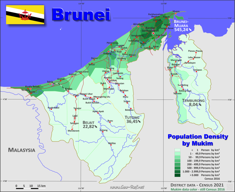
Brunei Darussalam map - Click the map to get map as PDF file.
Other language versions are easy to generate, the descriptions are in own layers
Conditions for thematic maps with your own data and logotype
Delivery as printable file by e-mail or plot by post office
|
|---|
| Layers | |
| Provinces: | yes |
| Streets: | yes |
| Infrastructure: | yes |
| Rivers: | yes |
|
| Size | Till A2 |
| Delivery time | 7 working days | | Price |
| 1 bis 3 | 70 € | | > 3 | On request |
|
 |
All information published herein is free usable quoting the source,
including the maps, if they are not modified
|
|---|
Statistical data - Population density according to the administrative structure
The population data of the table below is census data from 2021, last available data.
The Mukim-data is stil from the census 2016 - soon as posible we will update them. The area data between the two tables is not congruent.
Click on the column header brings the table in order of the column header.
The default order is the district name.
| District |
ISO
3166-2 |
Capital |
Area
(km²) |
Population |
Density
(pers/km²) |
| Total |
|
|
5 769 |
429 999 |
74,54 |
|---|
| Last update: 07/01/2025 - 12:48:07 |
|---|
| Belait |
BN-BE |
Kuala Belait |
2 727 |
62 243 |
22,82 |
| Brunei-Muara |
BN-BM |
Bandar Seri Begawan |
570 |
310 786 |
545,24 |
| Temburong |
BN-TE |
Bangar |
1 166 |
9 369 |
8,04 |
| Tutong |
BN-TU |
Tutong |
1 306 |
47 601 |
36,45 |
The districts are divided into mukims, the data of which are shown in the table below.
| Mukim |
HASC |
District |
Capital
| Area
(km²) |
Population |
Density
(pers/km²) |
| Total |
|
|
|
5 889,6 |
417 256 |
70,8 |
|---|
| Last update: 07/01/2025 - 12:48:07 |
|---|
| Amo |
BN.TE.AM |
Temburong |
Amo |
542,0 |
2 144 |
4,0 |
| Bangar |
BN.TE.BN |
Temburong |
Bangar |
113,0 |
2 449 |
21,7 |
| Batu Apoi |
BN.TE.BA |
Temburong |
Batu Apoi |
222,0 |
1 635 |
7,4 |
| Berakas A |
BN.BM.BE |
Brunei-Muara |
Berakas A |
44,6 |
27 223 |
610,4 |
| Berakas B |
|
Brunei-Muara |
Berakas B |
27,8 |
40 710 |
1 464,4 |
| Bokok |
BN.TE.BO |
Temburong |
Bokok |
136,0 |
3 433 |
25,2 |
| Bukit Sawat |
BN.BE.BS |
Belait |
Bukit Sawat |
297,8 |
794 |
2,7 |
| Burong Pinggai Ayer |
BN.BM.BP |
Brunei-Muara |
Burong Pinggai Ayer |
0,6 |
1 770 |
2 950,0 |
| Gadong A |
BN.BM.GA |
Brunei-Muara |
Gadong A |
49,7 |
34 049 |
685,1 |
| Gadong B |
|
Brunei-Muara |
Gadong B |
24,6 |
33 637 |
1 367,4 |
| Keriam |
BN.TU.KE |
Tutong |
Keriam |
121,9 |
9 707 |
79,6 |
| Kianggeh |
BN.BM.KG |
Brunei-Muara |
Kianggeh |
18,7 |
8 228 |
440,0 |
| Kilanas |
BN.BM.KL |
Brunei-Muara |
Kilanas |
32,7 |
22 492 |
687,8 |
| Kiudang |
BN.TU.KI |
Tutong |
Kiudang |
82,2 |
5 924 |
72,1 |
| Kota Batu |
BN.BM.KB |
Brunei-Muara |
Kota Batu |
57,0 |
12 935 |
226,9 |
| Kuala Balai |
BN.BE.BA |
Belait |
Kuala Balai |
320,1 |
31 |
0,1 |
| Kuala Belait |
BN.BE.BT |
Belait |
Kuala Belait |
87,9 |
31 308 |
356,2 |
| Labi |
BN.BE.LA |
Belait |
Labi |
361,8 |
1 216 |
3,4 |
| Labu |
BN.TE.LA |
Temburong |
Labu |
292,0 |
590 |
2,0 |
| Lamunin |
BN.TU.LA |
Tutong |
Lamunin |
109,9 |
4 298 |
39,1 |
| Liang |
BN.BE.LI |
Belait |
Lumut |
144,8 |
14 301 |
98,8 |
| Lumapas |
BN.BM.LU |
Brunei-Muara |
Lumapas |
62,1 |
7 756 |
124,9 |
| Melilas |
BN.BE.ME |
Belait |
Melilas |
607,5 |
29 |
0,0 |
| Mentiri |
BN.BM.ME |
Brunei-Muara |
Mentiri |
35,7 |
30 192 |
845,7 |
| Pekan Tutong |
BN.TU.PT |
Tutong |
Pekan Tutong |
43,2 |
10 551 |
244,2 |
| Pengkalan Batu |
BN.BM.PB |
Brunei-Muara |
Pengkalan Batu |
96,2 |
14 492 |
150,6 |
| Peramu |
BN.BM.PE |
Brunei-Muara |
Peramu |
0,3 |
1 111 |
3 703,3 |
| Rambai |
BN.TU.RA |
Tutong |
Rambai |
554,1 |
1 404 |
2,5 |
| Saba |
BN.BM.SA |
Brunei-Muara |
Saba |
0,2 |
1 000 |
5 000,0 |
| Sengkurong |
BN.BM.SN |
Brunei-Muara |
Sengkurong |
76,1 |
31 493 |
413,8 |
| Serasa |
BN.BM.SR |
Brunei-Muara |
Serasa |
34,8 |
16 173 |
464,7 |
| Seria |
BN.BE.SE |
Belait |
Seria |
169,0 |
21 214 |
125,5 |
| Sukang |
BN.BE.SU |
Belait |
Sukang |
815,1 |
169 |
0,2 |
| Sungai Kebun |
BN.BM.KE |
Brunei-Muara |
Sungai Kebun |
1,6 |
4 750 |
2 968,8 |
| Sungai Kedayan |
BN.BM.KD |
Brunei-Muara |
Sungai Kedayan |
0,3 |
230 |
766,7 |
| Tamoi |
BN.BM.TA |
Brunei-Muara |
Tamoi |
0,5 |
1 389 |
2 778,0 |
| Tanjong Maya |
BN.TU.TM |
Tutong |
Tanjong Maya |
68,5 |
4 062 |
59,3 |
| Telisai |
BN.TU.TE |
Tutong |
Telisai |
79,6 |
10 095 |
126,8 |
| Ukong |
BN.TU.UK |
Tutong |
Ukong |
157,7 |
2 272 |
14,4 |
Existing thematic maps
|
External links change quickly - If you get a link error - Please inform us!
 |
Membership in international organisations and treaties
Expand list
Political Alliances
Regional Unions
Military alliances/Arms control
Law enforcement
Business Alliances
Fishery
Financial
Free Trade Area, Internal Market
Technical alliances
Transport
Cientific
Humanitarian Unions
Cultural Unions
|
|
If you have suggestions to include other information or you find missed links, please inform us!
Click here ... |
See also neighboring states
|


