State of Israel
Country map - Administrative structure - Population density of Israel
Israel map - Click the map to get map as PDF file.
Other language versions are easy to generate, the descriptions are in own layers
Conditions for thematic maps with your own data and logotype
Delivery as printable file by e-mail or plot by post office
|
|---|
| Layers | |
| Provinces: | yes |
| Streets: | yes |
| Infrastructure: | yes |
| Rivers: | yes |
|
| Size | Till A2 |
| Delivery time | 7 working days | | Price |
| 1 bis 3 | 60 € | | > 3 | On request |
|
 |
All information published herein is free usable quoting the source,
including the maps, if they are not modified
|
|---|
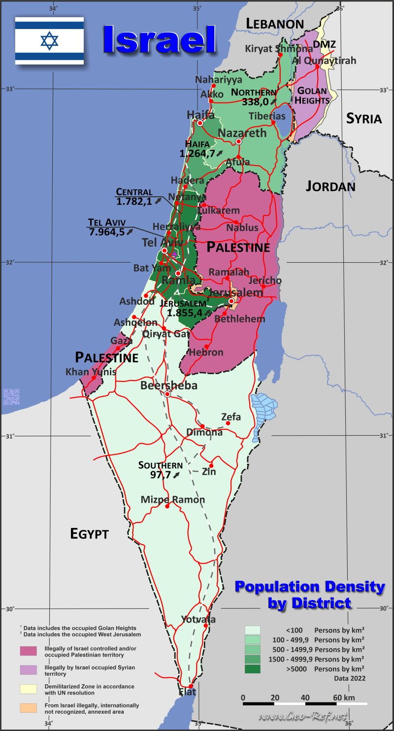
Statistical data - Population density according to the administrative structure
The population data of the table below is an estimation form 2020, based on the census 2008.
The data of Jerusalem and the Northern District contain populations living in the occupied areas.
Click on the column header brings the table in order of the column header.
The default order is the district name.
| District |
ISO
3166-2 |
Hebrew |
Capital |
Area
(km²) |
Population |
Density
(pers/km²) |
| Total |
|
|
|
27 536 |
9 140 300 |
331,9 |
|---|
| Last update: 17.01.2023 - 22:59:17 |
|---|
| Central District |
IL-HAM |
HaMerkaz |
Ramla |
1 293 |
2 233 000 |
1 727,0 |
| Haifa |
IL-HEF |
Hefa |
Haifa |
864 |
1 053 400 |
1 219,2 |
| Jerusalem |
IL-YER |
Yerushalayim |
Jerusalem |
652 |
1 159 900 |
1 779,0 |
| Northern District |
IL-HAZ |
HaZafon |
Nazareth |
4 478 |
1 469 400 |
328,1 |
| Southern District |
IL-HAD |
HaDarom |
Beersheba |
14 185 |
1 330 600 |
93,8 |
| Tel Aviv |
IL-TEL |
Tel Aviv |
Tel Aviv |
186 |
1 452 400 |
7 808,6 |
| West Bank & East Jerusalem (Occupied territories) |
- |
Yehuda ve-Shomron |
Only Israeli settlements |
5 878 |
441 600 |
- |
Existing thematic maps
|
External links change quickly - If you get a link error - Please inform us!
 |
Membership in international organisations and treaties
Expand list
Political Alliances
Regional Unions
Military alliances/Arms control
Law enforcement
Business Alliances
Fishery
Financial
Free Trade Area, Internal Market
Technical alliances
Transport
Cientific
Humanitarian Unions
Cultural Unions
|
|
If you have suggestions to include other information or you find missed links, please inform us!
Click here ... |
International Border disputes
Expand list
Land boundaries
Maritime boundaries
See also neighboring states
|
| |


