Republic of Cyprus
| Capital |
Currency | Government system |
|---|
| Nicosia |
Euro (EUR) |
Presidential system |
| Official language | Region |
Population |
|---|
Greek
Turkish |
Europe |
Census 2021
1 424 576 |
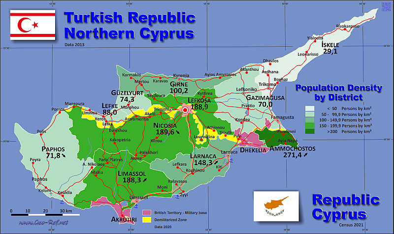
Country map - Administrative structure - Population density of Cyprus
Cyprus map - Click the map to get map as PDF file.
Other language versions are easy to generate, the descriptions are in own layers
Conditions for thematic maps with your own data and logotype
Delivery as printable file by e-mail or plot by post office
|
|---|
| Layers | |
| Provinces: | yes |
| Streets: | yes |
| Infrastructure: | yes |
| Rivers: | yes |
|
| Size | Till A2 |
| Delivery time | 7 working days | | Price |
| 1 bis 3 | 65 € | | > 3 | On request |
|
 |
All information published herein is free usable quoting the source,
including the maps, if they are not modified
|
|---|
Statistical data - Population density according to the administrative structure
The population of Cyprus data of the table below is census data from 2021, last available data.
The British Military Bases data corresponde to 2019 and the data of the
Turkish occupied part is based on an AI based estimation for 2024.
For the Turkish occupied part and the British Military Bases is
used the national codification instead the not defined ISO code.
Click on the column header brings the table in order of the column header.
The default order is the district name.
| District |
ISO
3166-2 |
Status |
Capital |
Area
(km²) |
Population |
Density
(pers/km²) |
| Total |
|
|
|
9 833 |
1 424 576 |
144,9 |
|---|
| Last update: 01/02/2026 - 19:46:00 |
|---|
| Akrotiri |
WSBA |
British Military Base |
- |
123 |
8 811 |
71,6 |
| Ammochostos |
CY-04 |
- |
Paralimni |
200 |
54 318 |
271,6 |
| Dhekelia |
ESBA |
British Military Base |
- |
131 |
9 384 |
71,6 |
| Gazimagusa |
GMG |
Occupied by Türkiye |
Famagusta |
997 |
95 406 |
95,7 |
| Girne |
GRI |
Occupied by Türkiye |
Kyrenia |
690 |
99 102 |
143,6 |
| Güzelyurt |
GÜZ |
Occupied by Türkiye |
Morphou |
255 |
36 025 |
28,9 |
| Green Zone |
UN |
UN buffer zone |
- |
346 |
10 000 |
141,3 |
| Iskele |
ISK |
Occupied by Türkiye |
Trikomo |
774 |
46 402 |
60,0 |
| Larnaca |
CY-03 |
- |
Larnaca |
1 050 |
155 765 |
148,3 |
| Lefke |
LEK |
Occupied by Türkiye |
Lefka |
126 |
22 922 |
181,9 |
| Lefkosa |
LEF |
Occupied by Türkiye |
North Nicosia |
502 |
173 143 |
344,9 |
| Limassol |
CY-02 |
- |
Limassol |
1 393 |
262 157 |
188,2 |
| Nicosia |
CY-01 |
- |
Nicosia |
1 850 |
350 035 |
189,2 |
| Paphos |
CY-05 |
- |
Nea Paphos |
1 396 |
101 106 |
72,4 |
Resumen
| Country part |
Area
(km²) |
Population |
Density
(pers/km²) |
| Chipre national area |
5 889 |
923 381 |
156,8 |
| British Military Base |
254 |
18 195 |
71,6 |
| Occupied by Türkiye |
3 344 |
473 000 |
141,4 |
| UN buffer zone |
346 |
10 000 |
28,9 |
| Total |
9 833 |
1 424 576 |
144,9 |
Existing thematic maps
|
External links change quickly - If you get a link error - Please inform us!
 |
Membership in international organisations and treaties
Expand list
Political Alliances
Regional Unions
Military alliances/Arms control
Law enforcement
Business Alliances
Fishery
Financial
Free Trade Area, Internal Market
Technical alliances
Transport
Cientific
Humanitarian Unions
Cultural Unions
|
|
If you have suggestions to include other information or you find missed links, please inform us!
Click here ... |
International Border disputes
Expand list
See also neighboring states
|
| |


