Montserrat
| Capital |
Currency | Government system |
|---|
| Plymouth |
Pound Sterling (GBP) |
Dependent from UK |
| Official language | Region |
Population |
|---|
| English |
Central America & Caribbean |
Census 2018
4 649 |
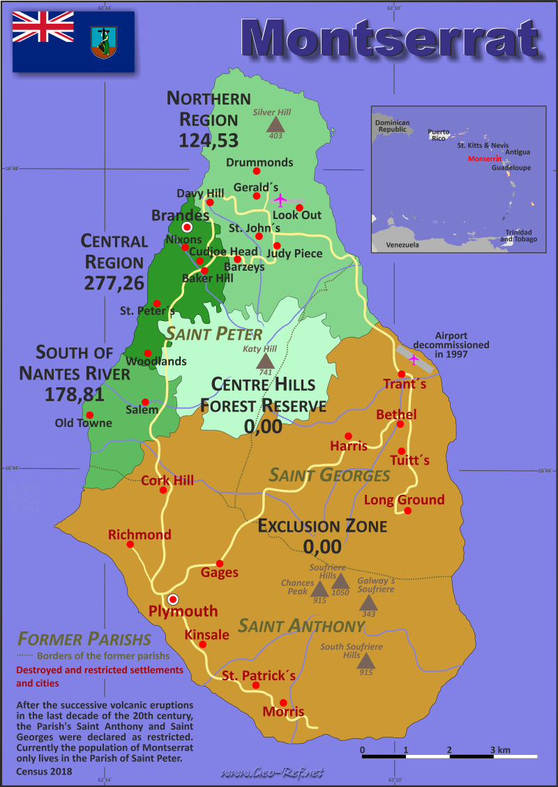
Country map - Administrative structure - Population density of Montserrat
Montserrat map - Click the map to get map as PDF file.
Other language versions are easy to generate, the descriptions are in own layers
Conditions for thematic maps with your own data and logotype
Delivery as printable file by e-mail or plot by post office
|
|---|
| Layers | |
| Provinces: | yes |
| Streets: | no |
| Infrastructure: | yes |
| Rivers: | yes |
|
| Size | Till A2 |
| Delivery time | 7 working days | | Price |
| 1 bis 3 | 50 € | | > 3 | On request |
|
 |
All information published herein is free usable quoting the source,
including the maps, if they are not modified
|
|---|
Statistical data - Population density according to the administrative structure
The population data of the table below is census data from 2018, last available data.
Click on the column header brings the table in order of the column header.
The default order is the parish name.
| Parish |
ISO
3166-2 |
Capital |
Area
(km²) |
Population |
Density
(pers/km²) |
| Total |
|
|
101,98 |
4 649 |
45,59 |
|---|
| Last update: 17.01.2023 - 22:59:28 |
|---|
| _Out of Census regions |
- |
- |
0 |
83 |
0,00 |
| Central Region |
CEN |
Brades |
5,32 |
1475 |
277,26 |
| Centre Hills Forest Reserve |
CHFR |
- |
10,5 |
0 |
0,00 |
| Exclusion Zone |
EXZ |
Plymouth |
63,6 |
0 |
0,00 |
| Northern Region |
NOR |
Look Out |
17,37 |
2163 |
124,53 |
| South of Nantes River |
SNR |
Salem |
5,19 |
928 |
178,81 |
Since the beginning of the
volcanic eruptions in 1995 in the south of the
island, the previous structure in
Parishs was abolished, as they had to relocate the
entire population from about 62% of the land area
to
the Parish of Saint Peter. The entire south del
island state is now a restricted area – the
Exclusion Zone.
For the 2018 Census, therefore, the Census regions
shown in the previous table were formed and
counted
on the basis of the population of the
communities.
The following table, on the next page, illustrate
the results by community.
| Community |
Sin |
Region |
Capital
| Area
(km²) |
Population |
Density
(pers/km²) |
| Total |
|
|
|
101,98 |
4 649 |
45,6 |
|---|
| Last update: 17.01.2023 - 22:59:28 |
|---|
| _Out of Census regions |
- |
|
- |
- |
83 |
0 |
| Baker Hill |
BH |
Central |
Baker Hill |
0,70 |
211 |
301,4 |
| Barzeys |
BA |
Northern |
Barzeys |
1,19 |
208 |
174,8 |
| Brades |
BR |
Central |
Brades |
1,11 |
393 |
354,1 |
| Centre Hills Forest Reserve |
CHFR |
Centre Hills Forest Reserve |
- |
10,50 |
0 |
0,0 |
| Cudjoe Head |
CH |
Central |
Cudjoe Head |
0,12 |
131 |
1 091,7 |
| Davy Hill |
DH |
Northern |
Davy Hill |
0,72 |
410 |
569,4 |
| Drummonds |
DR |
Northern |
Drummonds |
5,90 |
121 |
20,5 |
| Exclusion Zone |
EXZ |
Exclusion Zone |
Plymouth |
63,60 |
0 |
0,0 |
| Friths |
FR |
South |
Friths |
0,48 |
175 |
364,6 |
| Gerald's |
GE |
Northern |
Gerald's |
2,24 |
133 |
59,4 |
| Judy Piece |
JP |
Northern |
Judy Piece |
0,39 |
190 |
487,2 |
| Look Out |
LO |
Northern |
Look Out |
5,66 |
696 |
123,0 |
| Nixons |
NI |
Central |
Nixons |
0,33 |
118 |
357,6 |
| Old Towne |
OT |
South |
Old Towne |
2,40 |
109 |
45,4 |
| Olveston |
OL |
South |
Olveston |
1,27 |
324 |
255,1 |
| Salem |
SA |
South |
Salem |
1,04 |
320 |
307,7 |
| St John's |
SJ |
Northern |
St John's |
1,27 |
405 |
318,9 |
| St Peter's |
SP |
Central |
St Peter's |
2,00 |
380 |
190,0 |
| Woodlands |
WO |
Central |
Woodlands |
1,06 |
242 |
228,3 |
Existing thematic maps
|
External links change quickly - If you get a link error - Please inform us!
 |
Membership in international organisations and treaties
Expand list
Regional Unions
Law enforcement
Financial
Technical alliances
Humanitarian Unions
|
|
If you have suggestions to include other information or you find missed links, please inform us!
Click here ... |
International Border disputes
Expand list
See also neighboring states
|
| |


