Federal Democratic Republic of Ethiopia
| Capital |
Currency | Government system |
|---|
| Addis Abeba |
Birr (ETB) |
Parliamentary democracy |
| Official language | Region |
Population |
|---|
| Amharic |
Africa |
Estimation 2022
105 163 988 |
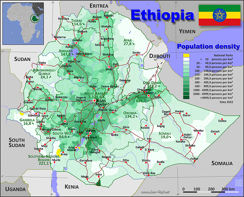
Country map - Administrative structure - Population density of Ethiopia
Ethiopia map - Click the map to get map as PDF file.
Other language versions are easy to generate, the descriptions are in own layers
Conditions for thematic maps with your own data and logotype
Delivery as printable file by e-mail or plot by post office
|
|---|
| Layers | |
| Provinces: | yes |
| Streets: | yes |
| Infrastructure: | yes |
| Rivers: | yes |
|
| Size | Till A2 |
| Delivery time | 7 working days | | Price |
| 1 bis 3 | 75 € | | > 3 | On request |
|
 |
All information published herein is free usable quoting the source,
including the maps, if they are not modified
|
|---|
Statistical data - Population density according to the administrative structure
The population data of the table below is an estimation form 2022, based on the census 2007.
Click on the column header brings the table in order of the column header.
The default order is the province name.
| Province |
ISO
3166-2 |
Capital |
Area
(km²) |
Population |
Density
(pers/km²) |
| Total |
|
|
1 111 126 |
105 163 988 |
94,6 |
|---|
| Last update: 11/04/202 - 00:44:01 |
|---|
| Addis Ababa |
ET-AA |
National Capital |
526 |
3 859 999 |
7 338,4 |
| Afar |
ET-AF |
Semera |
75 125 |
2 090 910 |
27,8 |
| Amhara |
ET-AM |
Bahir Dar |
154 805 |
22 876 991 |
147,8 |
| Benishangul-Gumuz |
ET-BE |
Asosa |
50 633 |
1 218 000 |
24,1 |
| Dire Dawa |
ET-DD |
Independent city |
1 559 |
535 000 |
343,2 |
| Gambela |
ET-GA |
Gambela |
30 254 |
508 004 |
16,8 |
| Harari |
ET-HA |
Harar |
334 |
276 000 |
826,3 |
| Oromia |
ET-OR |
Adama |
298 474 |
40 061 083 |
134,2 |
| Sidama |
ET-SI |
Awassa |
6 695 |
4 623 162 |
690,5 |
| Somali |
ET-SO |
Jijiga |
342 217 |
6 506 002 |
19,0 |
| South West |
ET-TBA |
Bonga |
39 060 |
3 302 952 |
84,6 |
| Southern Nations, Nationalities, and People's Regi |
ET-SN |
Awassa |
61 374 |
13 566 889 |
221,1 |
| Tigray |
ET-TI |
Mekelle |
50 070 |
5 738 996 |
114,6 |
The districts are subdivided into municipalities, and their data can be found in the following table.shown below.
| Municipality |
Own |
District |
Capital
| Area
(km²) |
Population |
Density
(pers/km²) |
| Total |
|
|
|
1 111 126 |
105 163 988 |
94,6 |
|---|
| Last update: 11/04/202 - 00:44:01 |
|---|
| Abala |
AF-001 |
Afar |
Abala |
1 189 |
60 898 |
51,2 |
| Abaya |
OR-001 |
Oromia |
Abaya |
1 205 |
147 573 |
122,5 |
| Abe Dongoro |
OR-002 |
Oromia |
Abe Dongoro |
1 096 |
95 389 |
87,0 |
| Abergele |
AM-001 |
Amhara |
Abergele |
1 767 |
51 791 |
29,3 |
| Abeshge |
SN-001 |
Southern |
Abeshge |
559 |
79 901 |
142,9 |
| Abey Chomen |
OR-003 |
Oromia |
Abey Chomen |
802 |
73 919 |
92,2 |
| Abichuna Gnaa |
OR-004 |
Oromia |
Abichuna Gnaa |
673 |
107 403 |
159,6 |
| Abiy Adi Town |
TI-001 |
Tigray |
Abiy Adi Town |
24 |
34 176 |
1 424,0 |
| Abobo |
GA-001 |
Gambela |
Abobo |
3 116 |
26 155 |
8,4 |
| Abuna Gindeberet |
OR-005 |
Oromia |
Abuna Gindeberet |
1 126 |
154 618 |
137,3 |
| Ada Berga |
OR-006 |
Oromia |
Ada Berga |
945 |
179 471 |
189,9 |
| Ada'a |
OR-007 |
Oromia |
Ada'a |
894 |
182 162 |
203,8 |
| Adaba |
OR-008 |
Oromia |
Adaba |
2 161 |
202 124 |
93,5 |
| Adadilo |
SO-001 |
Somali |
Adadilo |
8 675 |
120 814 |
13,9 |
| Adama |
OR-009 |
Oromia |
Adama |
871 |
234 986 |
269,8 |
| Adama Town |
OR-010 |
Oromia |
Adama Town |
30 |
456 868 |
15 228,9 |
| Adami Tulu Jido Kombolcha |
OR-011 |
Oromia |
Adami Tulu Jido Kombolcha |
1 095 |
211 827 |
193,4 |
| Addis Ketema |
AA-001 |
Addis Abeba |
Addis Ketema |
7 |
359 735 |
51 390,7 |
| Adi Arkay |
AM-002 |
Amhara |
Adi Arkay |
1 685 |
123 328 |
73,2 |
| Adigrat Town |
TI-002 |
Tigray |
Adigrat Town |
15 |
121 776 |
8 118,4 |
| Adola |
OR-012 |
Oromia |
Adola |
27 |
47 573 |
1 762,0 |
| Adola Town |
OR-013 |
Oromia |
Adola Town |
1 217 |
153 822 |
126,4 |
| Adwa |
TI-003 |
Tigray |
Adwa |
635 |
113 438 |
178,6 |
| Adwa Town |
TI-004 |
Tigray |
Adwa Town |
12 |
85 644 |
7 137,0 |
| Afambo |
AF-002 |
Afar |
Afambo |
1 259 |
32 064 |
25,5 |
| Afdem |
AF-003 |
Afar |
Afdem |
2 835 |
57 033 |
20,1 |
| Afdem |
SO-002 |
Somali |
Afdem |
3 223 |
95 640 |
29,7 |
| Afder |
SO-003 |
Somali |
Afder |
11 900 |
115 129 |
9,7 |
| Afdera |
AF-004 |
Afar |
Afdera |
7 435 |
45 683 |
6,1 |
| Agarfa |
OR-014 |
Oromia |
Agarfa |
1 222 |
151 469 |
124,0 |
| Agaro Town |
OR-015 |
Oromia |
Agaro Town |
8 |
52 802 |
6 600,3 |
| Agelo Meti |
BE-001 |
Benishangul-Gumuz |
Agelo Meti |
1 751 |
33 828 |
19,3 |
| Ahiferom |
TI-005 |
Tigray |
Ahiferom |
1 303 |
220 575 |
169,3 |
| Akaki |
OR-016 |
Oromia |
Akaki |
583 |
113 316 |
194,4 |
| Akaki Kaliti |
AA-002 |
Addis Abeba |
Akaki Kaliti |
118 |
255 348 |
2 164,0 |
| Akobo |
GA-002 |
Gambela |
Akobo |
2 080 |
34 405 |
16,5 |
| Aksum Town |
TI-006 |
Tigray |
Aksum Town |
17 |
94 515 |
5 559,7 |
| Alaba |
SN-002 |
Southern |
Alaba |
995 |
339 423 |
341,1 |
| Alaje |
TI-007 |
Tigray |
Alaje |
756 |
130 287 |
172,3 |
| Alamata |
TI-008 |
Tigray |
Alamata |
545 |
101 627 |
186,5 |
| Alamata Town |
TI-009 |
Tigray |
Alamata Town |
6 |
70 441 |
11 740,2 |
| Albuko |
AM-003 |
Amhara |
Albuko |
477 |
96 179 |
201,6 |
| Ale |
OR-017 |
Oromia |
Ale |
830 |
95 968 |
115,6 |
| Alefa |
AM-004 |
Amhara |
Alefa |
1 962 |
216 632 |
110,4 |
| Aleltu |
OR-018 |
Oromia |
Aleltu |
510 |
77 280 |
151,5 |
| Aleta Wendo |
SI-001 |
Sidama |
Aleta Wendo |
231 |
276 385 |
1 196,5 |
| Alge Sachi |
OR-019 |
Oromia |
Alge Sachi |
875 |
112 084 |
128,1 |
| Alicho Werero |
SN-003 |
Southern |
Alicho Werero |
263 |
121 378 |
461,5 |
| Amaro |
SN-004 |
Southern |
Amaro |
1 422 |
206 022 |
144,9 |
| Ambasel |
AM-005 |
Amhara |
Ambasel |
882 |
152 372 |
172,8 |
| Ambo Town |
OR-020 |
Oromia |
Ambo Town |
10 |
99 905 |
9 990,5 |
| Ambo Zuria |
OR-021 |
Oromia |
Ambo Zuria |
950 |
152 143 |
160,2 |
| Ameya |
OR-022 |
Oromia |
Ameya |
927 |
174 866 |
188,6 |
| Amibara |
AF-005 |
Afar |
Amibara |
2 007 |
114 496 |
57,0 |
| Amigna |
OR-023 |
Oromia |
Amigna |
1 304 |
106 743 |
81,9 |
| Amuru |
OR-024 |
Oromia |
Amuru |
1 295 |
76 895 |
59,4 |
| Analimo |
SN-005 |
Southern |
Analimo |
224 |
96 918 |
432,7 |
| Anchar |
OR-025 |
Oromia |
Anchar |
827 |
118 516 |
143,3 |
| Anderacha |
TBA-001 |
South West |
Anderacha |
1 020 |
34 834 |
34,2 |
| Aneded |
AM-006 |
Amhara |
Aneded |
679 |
111 263 |
163,9 |
| Anfilo |
OR-026 |
Oromia |
Anfilo |
1 658 |
113 163 |
68,3 |
| Angacha |
SN-006 |
Southern |
Angacha |
153 |
124 035 |
810,7 |
| Angolala Tera |
AM-007 |
Amhara |
Angolala Tera |
783 |
104 671 |
133,7 |
| Ankaska Guagusa |
AM-008 |
Amhara |
Ankaska Guagusa |
1 044 |
256 973 |
246,1 |
| Ankober |
AM-009 |
Amhara |
Ankober |
673 |
96 367 |
143,2 |
| Antsokiya Gemza |
AM-010 |
Amhara |
Antsokiya Gemza |
372 |
108 070 |
290,5 |
| Arada |
AA-003 |
Addis Abeba |
Arada |
10 |
298 044 |
29 804,4 |
| Arba Minch Town |
SN-007 |
Southern |
Arba Minch Town |
33 |
201 049 |
6 092,4 |
| Arba Minch Zuriya |
SN-008 |
Southern |
Arba Minch Zuriya |
968 |
214 020 |
221,1 |
| Arbegona |
SI-002 |
Sidama |
Arbegona |
341 |
186 021 |
545,5 |
| Arero |
OR-027 |
Oromia |
Arero |
7 335 |
69 309 |
9,4 |
| Argoba |
AM-011 |
Amhara |
Argoba |
306 |
41 968 |
137,2 |
| Argoba Liyu |
AF-006 |
Afar |
Argoba Liyu |
394 |
30 613 |
77,7 |
| Aroresa |
SI-003 |
Sidama |
Aroresa |
682 |
225 582 |
330,8 |
| Arsi Negele |
OR-028 |
Oromia |
Arsi Negele |
1 281 |
398 551 |
311,1 |
| Artuma Fursi |
AM-012 |
Amhara |
Artuma Fursi |
688 |
105 619 |
153,5 |
| Asagirt |
AM-013 |
Amhara |
Asagirt |
500 |
59 351 |
118,7 |
| Asayita |
AF-007 |
Afar |
Asayita |
1 678 |
84 161 |
50,2 |
| Aseko |
OR-029 |
Oromia |
Aseko |
542 |
120 283 |
221,9 |
| Asela Town |
OR-030 |
Oromia |
Asela Town |
17 |
139 537 |
8 208,1 |
| Asgede Tsimbla |
TI-010 |
Tigray |
Asgede Tsimbla |
2 358 |
164 146 |
69,6 |
| Asossa |
BE-002 |
Benishangul-Gumuz |
Asossa |
2 918 |
177 292 |
60,8 |
| Atsbi Wonberta |
TI-011 |
Tigray |
Atsbi Wonberta |
885 |
138 712 |
156,7 |
| Awabel |
AM-014 |
Amhara |
Awabel |
807 |
158 301 |
196,2 |
| Aware |
SO-004 |
Somali |
Aware |
9 772 |
141 011 |
14,4 |
| Awasa Town |
SI-004 |
Sidama |
Awasa Town |
157 |
555 480 |
3 538,1 |
| Awash Fentale |
AF-008 |
Afar |
Awash Fentale |
1 046 |
58 016 |
55,5 |
| Awra |
AF-009 |
Afar |
Awra |
2 318 |
46 494 |
20,1 |
| Awubere |
SO-005 |
Somali |
Awubere |
3 314 |
496 198 |
149,7 |
| Ayida |
SN-009 |
Southern |
Ayida |
175 |
43 329 |
247,6 |
| Ayira |
OR-031 |
Oromia |
Ayira |
516 |
70 574 |
136,8 |
| Ayisha |
SO-006 |
Somali |
Ayisha |
9 321 |
85 155 |
9,1 |
| Babile |
OR-032 |
Oromia |
Babile |
596 |
142 988 |
239,9 |
| Babile |
SO-007 |
Somali |
Babile |
1 245 |
112 198 |
90,1 |
| Babo Gambel |
OR-033 |
Oromia |
Babo Gambel |
902 |
87 107 |
96,6 |
| Bahir Dar Town |
AM-015 |
Amhara |
Bahir Dar Town |
213 |
455 901 |
2 140,4 |
| Bahri Dar Zuria |
AM-016 |
Amhara |
Bahri Dar Zuria |
1 443 |
219 106 |
151,8 |
| Bako Tibe |
OR-034 |
Oromia |
Bako Tibe |
638 |
187 456 |
293,8 |
| Bale Gasegar |
OR-035 |
Oromia |
Bale Gasegar |
550 |
107 393 |
195,3 |
| Bambasi |
BE-003 |
Benishangul-Gumuz |
Bambasi |
1 462 |
79 558 |
54,4 |
| Banja Shekudad |
AM-017 |
Amhara |
Banja Shekudad |
508 |
158 003 |
311,0 |
| Bare |
SO-008 |
Somali |
Bare |
8 278 |
135 360 |
16,4 |
| Basketo |
SN-010 |
Southern |
Basketo |
411 |
80 983 |
197,0 |
| Baso Liben |
AM-018 |
Amhara |
Baso Liben |
1 119 |
172 686 |
154,3 |
| Basona Werana |
AM-019 |
Amhara |
Basona Werana |
1 208 |
146 283 |
121,1 |
| Bati |
AM-020 |
Amhara |
Bati |
1 132 |
146 317 |
129,3 |
| Becho |
OR-036 |
Oromia |
Becho |
437 |
113 264 |
259,2 |
| Bedele Town |
OR-037 |
Oromia |
Bedele Town |
9 |
40 483 |
4 498,1 |
| Bedele Zuria |
OR-038 |
Oromia |
Bedele Zuria |
745 |
108 613 |
145,8 |
| Bedeno |
OR-039 |
Oromia |
Bedeno |
822 |
340 232 |
413,9 |
| Bedesa Town |
OR-040 |
Oromia |
Bedesa Town |
3 |
37 706 |
12 568,7 |
| Begi |
OR-041 |
Oromia |
Begi |
921 |
172 724 |
187,5 |
| Belo Jegonfoy |
BE-004 |
Benishangul-Gumuz |
Belo Jegonfoy |
1 621 |
44 798 |
27,6 |
| Bena Tsemay |
SN-011 |
Southern |
Bena Tsemay |
2 923 |
71 850 |
24,6 |
| Bensa |
SI-005 |
Sidama |
Bensa |
551 |
342 116 |
620,9 |
| Berahile |
AF-010 |
Afar |
Berahile |
2 509 |
108 555 |
43,3 |
| Berbere |
OR-042 |
Oromia |
Berbere |
1 547 |
130 527 |
84,4 |
| Bereh |
OR-043 |
Oromia |
Bereh |
737 |
112 967 |
153,3 |
| Berehet |
AM-021 |
Amhara |
Berehet |
791 |
45 931 |
58,1 |
| Bero |
TBA-002 |
South West |
Bero |
610 |
18 523 |
30,4 |
| Beyeda |
AM-022 |
Amhara |
Beyeda |
973 |
120 360 |
123,7 |
| Bibugn |
AM-023 |
Amhara |
Bibugn |
400 |
104 935 |
262,3 |
| Bicho |
OR-044 |
Oromia |
Bicho |
459 |
35 928 |
78,3 |
| Bilo Nopha |
OR-045 |
Oromia |
Bilo Nopha |
397 |
41 635 |
104,9 |
| Bishoftu Town |
OR-046 |
Oromia |
Bishoftu Town |
40 |
207 383 |
5 184,6 |
| Bita |
TBA-003 |
South West |
Bita |
1 089 |
100 830 |
92,6 |
| Boh |
SO-009 |
Somali |
Boh |
13 360 |
150 152 |
11,2 |
| Boji Chekorsa |
OR-047 |
Oromia |
Boji Chekorsa |
344 |
69 328 |
201,5 |
| Boji Dirmeji |
OR-048 |
Oromia |
Boji Dirmeji |
531 |
64 797 |
122,0 |
| Boke |
OR-049 |
Oromia |
Boke |
3 499 |
215 830 |
61,7 |
| Bole |
AA-004 |
Addis Abeba |
Bole |
122 |
435 421 |
3 569,0 |
| Boloso Bonibe |
SN-012 |
Southern |
Boloso Bonibe |
272 |
115 883 |
426,0 |
| Boloso Sore |
SN-013 |
Southern |
Boloso Sore |
303 |
301 147 |
993,9 |
| Bona Zuria |
SI-006 |
Sidama |
Bona Zuria |
230 |
166 043 |
721,9 |
| Boneya Bushe |
OR-050 |
Oromia |
Boneya Bushe |
474 |
68 789 |
145,1 |
| Bonga Town |
TBA-004 |
South West |
Bonga Town |
14 |
56 045 |
4 003,2 |
| Bonke |
SN-014 |
Southern |
Bonke |
792 |
215 775 |
272,4 |
| Bora |
OR-051 |
Oromia |
Bora |
436 |
89 828 |
206,0 |
| Bore |
OR-052 |
Oromia |
Bore |
1 284 |
300 766 |
234,2 |
| Borecha |
OR-053 |
Oromia |
Borecha |
740 |
104 883 |
141,7 |
| Boreda |
SN-015 |
Southern |
Boreda |
464 |
92 222 |
198,8 |
| Boricha |
SI-007 |
Sidama |
Boricha |
588 |
339 933 |
578,1 |
| Boset |
OR-054 |
Oromia |
Boset |
1 434 |
216 576 |
151,0 |
| Bugna |
AM-024 |
Amhara |
Bugna |
1 303 |
90 524 |
69,5 |
| Bule |
SN-016 |
Southern |
Bule |
273 |
144 474 |
529,2 |
| Bule Hora |
OR-055 |
Oromia |
Bule Hora |
1 684 |
393 573 |
233,7 |
| Bulen |
BE-005 |
Benishangul-Gumuz |
Bulen |
2 963 |
71 280 |
24,1 |
| Burayu |
OR-056 |
Oromia |
Burayu |
86 |
122 397 |
1 423,2 |
| Bure |
AM-025 |
Amhara |
Bure |
800 |
199 053 |
248,8 |
| Bure |
OR-057 |
Oromia |
Bure |
1 156 |
74 786 |
64,7 |
| Bure Mudayitu |
AF-011 |
Afar |
Bure Mudayitu |
702 |
40 879 |
58,2 |
| Burji |
SN-017 |
Southern |
Burji |
1 128 |
81 167 |
72,0 |
| Bursa |
SI-008 |
Sidama |
Bursa |
222 |
137 982 |
621,5 |
| Butajira Town |
SN-018 |
Southern |
Butajira Town |
16 |
89 824 |
5 614,0 |
| Cheha |
SN-019 |
Southern |
Cheha |
573 |
163 307 |
285,0 |
| Cheko |
SI-009 |
Sidama |
Cheko |
308 |
225 450 |
732,0 |
| Cheliya |
OR-058 |
Oromia |
Cheliya |
921 |
234 814 |
255,0 |
| Chena |
TBA-005 |
South West |
Chena |
1 058 |
222 310 |
210,1 |
| Chencha |
SN-020 |
Southern |
Chencha |
374 |
163 789 |
437,9 |
| Chere |
SI-010 |
Sidama |
Chere |
366 |
159 944 |
437,0 |
| Cheta |
TBA-006 |
South West |
Cheta |
686 |
44 479 |
64,8 |
| Chewaka |
OR-059 |
Oromia |
Chewaka |
619 |
79 127 |
127,8 |
| Chifra |
AF-012 |
Afar |
Chifra |
1 519 |
127 884 |
84,2 |
| Chilga |
AM-026 |
Amhara |
Chilga |
3 072 |
287 299 |
93,5 |
| Chinaksan |
OR-060 |
Oromia |
Chinaksan |
779 |
129 986 |
166,9 |
| Chiro Town |
OR-061 |
Oromia |
Chiro Town |
6 |
69 793 |
11 632,2 |
| Chiro Zuria |
OR-062 |
Oromia |
Chiro Zuria |
710 |
237 521 |
334,5 |
| Chole |
OR-063 |
Oromia |
Chole |
585 |
129 391 |
221,2 |
| Chora |
OR-064 |
Oromia |
Chora |
789 |
145 736 |
184,7 |
| Chora Botor |
OR-065 |
Oromia |
Chora Botor |
1 628 |
128 952 |
79,2 |
| Dabat |
AM-027 |
Amhara |
Dabat |
1 188 |
191 048 |
160,8 |
| Dabo Hana |
OR-066 |
Oromia |
Dabo Hana |
747 |
60 541 |
81,0 |
| Dale |
SI-011 |
Sidama |
Dale |
277 |
357 733 |
1 291,5 |
| Dale Sadi |
OR-067 |
Oromia |
Dale Sadi |
579 |
106 704 |
184,3 |
| Dale Wabera |
OR-068 |
Oromia |
Dale Wabera |
803 |
155 473 |
193,6 |
| Dalifage |
AF-013 |
Afar |
Dalifage |
955 |
52 299 |
54,8 |
| Dalocha |
SN-021 |
Southern |
Dalocha |
351 |
126 233 |
359,6 |
| Dalol |
AF-014 |
Afar |
Dalol |
2 291 |
110 066 |
48,0 |
| Damot Gale |
SN-022 |
Southern |
Damot Gale |
256 |
230 022 |
898,5 |
| Damot Pulasa |
SN-023 |
Southern |
Damot Pulasa |
165 |
144 197 |
873,9 |
| Damot Sore |
SN-024 |
Southern |
Damot Sore |
181 |
139 440 |
770,4 |
| Damot Woyide |
SN-025 |
Southern |
Damot Woyide |
352 |
126 510 |
359,4 |
| Danan |
SO-010 |
Somali |
Danan |
5 351 |
35 148 |
6,6 |
| Dangila |
AM-028 |
Amhara |
Dangila |
918 |
218 765 |
238,3 |
| Dangur |
BE-006 |
Benishangul-Gumuz |
Dangur |
4 685 |
78 133 |
16,7 |
| Dano |
OR-069 |
Oromia |
Dano |
660 |
140 056 |
212,2 |
| Danot |
SO-011 |
Somali |
Danot |
8 753 |
68 383 |
7,8 |
| Dara |
SI-012 |
Sidama |
Dara |
250 |
216 756 |
867,0 |
| Darimu |
OR-070 |
Oromia |
Darimu |
1 382 |
205 690 |
148,8 |
| Daro Lebu |
OR-071 |
Oromia |
Daro Lebu |
4 409 |
288 304 |
65,4 |
| Dasenech |
SN-026 |
Southern |
Dasenech |
2 102 |
71 846 |
34,2 |
| Dawa Chefa |
AM-029 |
Amhara |
Dawa Chefa |
652 |
162 982 |
250,0 |
| Dawe |
AF-015 |
Afar |
Dawe |
761 |
57 117 |
75,1 |
| Dawe Harewa |
AM-030 |
Amhara |
Dawe Harewa |
376 |
51 399 |
136,7 |
| Dawe Kachen |
OR-072 |
Oromia |
Dawe Kachen |
2 824 |
43 587 |
15,4 |
| Dawe Serer |
OR-073 |
Oromia |
Dawe Serer |
n.d. |
60 357 |
n.d. |
| Dawo |
OR-074 |
Oromia |
Dawo |
501 |
120 453 |
240,4 |
| Dawunt |
AM-031 |
Amhara |
Dawunt |
618 |
78 930 |
127,7 |
| Debark |
AM-032 |
Amhara |
Debark |
1 461 |
212 732 |
145,6 |
| Debay Tilatgen |
AM-033 |
Amhara |
Debay Tilatgen |
626 |
158 823 |
253,7 |
| Debere Libanos |
OR-075 |
Oromia |
Debere Libanos |
294 |
69 208 |
235,4 |
| Debewoin |
SO-012 |
Somali |
Debewoin |
3 371 |
102 287 |
30,3 |
| Debre Birhan |
AM-034 |
Amhara |
Debre Birhan |
146 |
146 918 |
1 006,3 |
| Debre Elias |
AM-035 |
Amhara |
Debre Elias |
1 166 |
106 864 |
91,7 |
| Debre Markos Town |
AM-036 |
Amhara |
Debre Markos Town |
66 |
140 699 |
2 131,8 |
| Debre Tabor Town |
AM-037 |
Amhara |
Debre Tabor Town |
111 |
125 312 |
1 128,9 |
| Debresina |
AM-038 |
Amhara |
Debresina |
1 028 |
198 950 |
193,5 |
| Debub Achefer |
AM-039 |
Amhara |
Debub Achefer |
1 103 |
176 088 |
159,6 |
| Debub Ari |
SN-027 |
Southern |
Debub Ari |
1 521 |
316 792 |
208,3 |
| Debub Bench |
TBA-007 |
South West |
Debub Bench |
625 |
152 945 |
244,7 |
| Decha |
TBA-008 |
South West |
Decha |
2 959 |
175 261 |
59,2 |
| Deder |
OR-076 |
Oromia |
Deder |
647 |
353 505 |
546,4 |
| Dedesa |
OR-077 |
Oromia |
Dedesa |
842 |
122 552 |
145,5 |
| Dedo |
OR-078 |
Oromia |
Dedo |
1 516 |
407 175 |
268,6 |
| Dega |
OR-079 |
Oromia |
Dega |
354 |
57 222 |
161,6 |
| Dega Damot |
AM-040 |
Amhara |
Dega Damot |
831 |
189 806 |
228,4 |
| Dega Temben |
TI-012 |
Tigray |
Dega Temben |
1 110 |
136 330 |
122,8 |
| Degehabur |
SO-013 |
Somali |
Degehabur |
8 793 |
170 713 |
19,4 |
| Degehamedo |
SO-014 |
Somali |
Degehamedo |
3 071 |
84 482 |
27,5 |
| Degem |
OR-080 |
Oromia |
Degem |
649 |
142 720 |
219,9 |
| Deguna Fanigo |
SN-028 |
Southern |
Deguna Fanigo |
402 |
130 244 |
324,0 |
| Dehena |
AM-041 |
Amhara |
Dehena |
1 643 |
135 987 |
82,8 |
| Dejen |
AM-042 |
Amhara |
Dejen |
621 |
131 930 |
212,4 |
| Deksis |
OR-081 |
Oromia |
Deksis |
399 |
106 397 |
266,7 |
| Delanta |
AM-043 |
Amhara |
Delanta |
1 057 |
161 511 |
152,8 |
| Dembecha |
AM-044 |
Amhara |
Dembecha |
971 |
173 905 |
179,1 |
| Dembia |
AM-045 |
Amhara |
Dembia |
1 262 |
349 512 |
277,0 |
| Denbel |
SO-015 |
Somali |
Denbel |
2 785 |
120 798 |
43,4 |
| Denbi Dollo Town |
OR-082 |
Oromia |
Denbi Dollo Town |
17 |
61 070 |
3 592,4 |
| Dendi |
OR-083 |
Oromia |
Dendi |
979 |
248 912 |
254,3 |
| Deniboya |
SN-029 |
Southern |
Deniboya |
163 |
118 721 |
728,3 |
| Denibu Gofa |
SN-030 |
Southern |
Denibu Gofa |
796 |
105 580 |
132,6 |
| Dera |
AM-046 |
Amhara |
Dera |
1 525 |
315 557 |
206,9 |
| Dera |
OR-084 |
Oromia |
Dera |
1 597 |
258 746 |
162,0 |
| Deramalo |
SN-031 |
Southern |
Deramalo |
362 |
109 842 |
303,4 |
| Derashe |
SN-032 |
Southern |
Derashe |
1 487 |
204 041 |
137,2 |
| Dese |
AM-047 |
Amhara |
Dese |
199 |
307 638 |
1 545,9 |
| Dessie Zuria |
AM-048 |
Amhara |
Dessie Zuria |
937 |
189 114 |
201,8 |
| Dibate |
BE-007 |
Benishangul-Gumuz |
Dibate |
2 203 |
101 051 |
45,9 |
| Didu |
OR-085 |
Oromia |
Didu |
735 |
46 418 |
63,2 |
| Diga |
OR-086 |
Oromia |
Diga |
586 |
98 893 |
168,8 |
| Digluna Tijo |
OR-087 |
Oromia |
Digluna Tijo |
928 |
205 916 |
221,9 |
| Dihun |
SO-016 |
Somali |
Dihun |
3 904 |
36 496 |
9,3 |
| Dila Town |
SN-033 |
Southern |
Dila Town |
14 |
158 795 |
11 342,5 |
| Dila Zuria |
SN-034 |
Southern |
Dila Zuria |
122 |
128 050 |
1 049,6 |
| Dima |
GA-003 |
Gambela |
Dima |
7 762 |
13 322 |
1,7 |
| Dima |
OR-088 |
Oromia |
Dima |
325 |
80 521 |
247,8 |
| Dinsho |
OR-089 |
Oromia |
Dinsho |
650 |
56 707 |
87,2 |
| Dire |
OR-090 |
Oromia |
Dire |
10 317 |
106 761 |
10,3 |
| Dire Dawa |
DD-001 |
Dire Dawa |
Dire Dawa |
1 559 |
535 000 |
343,2 |
| Dita |
SN-035 |
Southern |
Dita |
283 |
113 404 |
400,7 |
| Doba |
OR-091 |
Oromia |
Doba |
729 |
189 443 |
259,9 |
| Dodola |
OR-092 |
Oromia |
Dodola |
1 656 |
294 066 |
177,6 |
| Dodota |
OR-093 |
Oromia |
Dodota |
507 |
102 849 |
202,9 |
| Dolo Mena |
OR-094 |
Oromia |
Dolo Mena |
4 893 |
132 559 |
27,1 |
| Dolo Odo |
SO-017 |
Somali |
Dolo Odo |
7 303 |
166 118 |
22,7 |
| Dolobay |
SO-018 |
Somali |
Dolobay |
1 948 |
122 543 |
62,9 |
| Doreni |
OR-095 |
Oromia |
Doreni |
460 |
51 316 |
111,6 |
| Doyogena |
SN-036 |
Southern |
Doyogena |
131 |
111 623 |
852,1 |
| Dubti |
AF-016 |
Afar |
Dubti |
5 934 |
122 641 |
20,7 |
| Dugda |
OR-096 |
Oromia |
Dugda |
924 |
227 064 |
245,7 |
| Dugida Dawa |
OR-097 |
Oromia |
Dugida Dawa |
3 864 |
209 712 |
54,3 |
| Dulacha |
AF-017 |
Afar |
Dulacha |
1 477 |
28 039 |
19,0 |
| Duna |
SN-037 |
Southern |
Duna |
223 |
166 826 |
748,1 |
| Durame Town |
SN-038 |
Southern |
Durame Town |
14 |
65 852 |
4 703,7 |
| Ebinat |
AM-049 |
Amhara |
Ebinat |
2 481 |
276 611 |
111,5 |
| Efrata Gidim |
AM-050 |
Amhara |
Efrata Gidim |
517 |
148 674 |
287,6 |
| Ejere |
OR-098 |
Oromia |
Ejere |
581 |
128 341 |
220,9 |
| Elfata |
OR-099 |
Oromia |
Elfata |
445 |
81 516 |
183,2 |
| Elidar |
AF-018 |
Afar |
Elidar |
11 636 |
113 755 |
9,8 |
| Enarj Enawga |
AM-051 |
Amhara |
Enarj Enawga |
933 |
215 080 |
230,5 |
| Endamehoni |
TI-013 |
Tigray |
Endamehoni |
590 |
99 307 |
168,3 |
| Endegagn |
SN-039 |
Southern |
Endegagn |
151 |
65 024 |
430,6 |
| Enderta |
TI-014 |
Tigray |
Enderta |
1 270 |
130 020 |
102,4 |
| Enebse Sar Midir |
AM-052 |
Amhara |
Enebse Sar Midir |
1 075 |
173 450 |
161,3 |
| Enemay |
AM-053 |
Amhara |
Enemay |
733 |
218 116 |
297,6 |
| Enemorna Ener |
SN-040 |
Southern |
Enemorna Ener |
915 |
227 373 |
248,5 |
| Enkelo Wabe |
OR-100 |
Oromia |
Enkelo Wabe |
318 |
86 473 |
271,9 |
| Ensaro |
AM-054 |
Amhara |
Ensaro |
442 |
73 111 |
165,4 |
| Erebti |
AF-019 |
Afar |
Erebti |
2 612 |
45 654 |
17,5 |
| Erer |
SO-019 |
Somali |
Erer |
10 250 |
113 929 |
11,1 |
| Erob |
TI-015 |
Tigray |
Erob |
934 |
31 035 |
33,2 |
| Etang |
GA-004 |
Gambela |
Etang |
2 188 |
55 507 |
25,4 |
| Ewa |
AF-020 |
Afar |
Ewa |
1 464 |
62 178 |
42,5 |
| Ezha |
SN-041 |
Southern |
Ezha |
334 |
115 608 |
346,1 |
| Fagita Lekoma |
AM-055 |
Amhara |
Fagita Lekoma |
653 |
160 936 |
246,5 |
| Farta |
AM-056 |
Amhara |
Farta |
1 099 |
285 572 |
259,8 |
| Fedis |
OR-101 |
Oromia |
Fedis |
721 |
161 214 |
223,6 |
| Fentale |
OR-102 |
Oromia |
Fentale |
1 522 |
128 122 |
84,2 |
| Ferfer |
SO-020 |
Somali |
Ferfer |
1 969 |
57 159 |
29,0 |
| Fiche Town |
OR-103 |
Oromia |
Fiche Town |
13 |
57 067 |
4 389,8 |
| Fik |
SO-021 |
Somali |
Fik |
8 633 |
189 442 |
21,9 |
| Filtu |
SO-022 |
Somali |
Filtu |
16 750 |
189 803 |
11,3 |
| Finote Selam Town |
AM-057 |
Amhara |
Finote Selam Town |
43 |
58 429 |
1 358,8 |
| Fogera |
AM-058 |
Amhara |
Fogera |
1 111 |
300 473 |
270,5 |
| Gambela National Park |
GA-005 |
Gambela |
Gambela National Park |
472 |
0 |
0,0 |
| Gambela Town |
GA-006 |
Gambela |
Gambela Town |
16 |
97 643 |
6 102,7 |
| Gambela Zuria |
GA-007 |
Gambela |
Gambela Zuria |
3 119 |
15 705 |
5,0 |
| Ganta Afeshum |
TI-016 |
Tigray |
Ganta Afeshum |
511 |
104 431 |
204,4 |
| Gasera |
OR-104 |
Oromia |
Gasera |
1 129 |
112 587 |
99,7 |
| Gashamo |
SO-023 |
Somali |
Gashamo |
10 480 |
138 537 |
13,2 |
| Gawo Kebe |
OR-105 |
Oromia |
Gawo Kebe |
1 173 |
92 592 |
78,9 |
| Gazgibla |
AM-059 |
Amhara |
Gazgibla |
1 037 |
84 969 |
81,9 |
| Gechi |
OR-106 |
Oromia |
Gechi |
634 |
102 212 |
161,2 |
| Gedeb |
SN-042 |
Southern |
Gedeb |
320 |
197 082 |
615,9 |
| Gedeb Asasa |
OR-107 |
Oromia |
Gedeb Asasa |
1 148 |
275 293 |
239,8 |
| Geladin |
SO-024 |
Somali |
Geladin |
12 600 |
142 512 |
11,3 |
| Gelana |
OR-108 |
Oromia |
Gelana |
1 369 |
102 141 |
74,6 |
| Gemches |
OR-109 |
Oromia |
Gemches |
1 042 |
260 167 |
249,7 |
| Genabosa |
TBA-009 |
South West |
Genabosa |
923 |
114 558 |
124,1 |
| Genji |
OR-110 |
Oromia |
Genji |
303 |
85 873 |
283,4 |
| Gera |
OR-111 |
Oromia |
Gera |
1 454 |
160 339 |
110,3 |
| Gerbo |
SO-025 |
Somali |
Gerbo |
6 319 |
66 476 |
10,5 |
| Gesha Deka |
TBA-010 |
South West |
Gesha Deka |
714 |
115 451 |
161,7 |
| Geta |
SN-043 |
Southern |
Geta |
202 |
90 347 |
447,3 |
| Gewane |
AF-021 |
Afar |
Gewane |
968 |
47 311 |
48,9 |
| Gewata |
TBA-011 |
South West |
Gewata |
906 |
96 270 |
106,3 |
| Gezegofa |
SN-044 |
Southern |
Gezegofa |
527 |
97 282 |
184,6 |
| Gibe |
SN-045 |
Southern |
Gibe |
448 |
149 118 |
332,9 |
| Gida Kiremu |
OR-112 |
Oromia |
Gida Kiremu |
2 541 |
240 109 |
94,5 |
| Gidami |
OR-113 |
Oromia |
Gidami |
2 190 |
123 880 |
56,6 |
| Gidan |
AM-060 |
Amhara |
Gidan |
1 090 |
198 127 |
181,8 |
| Gimbi |
OR-114 |
Oromia |
Gimbi |
1 010 |
104 335 |
103,3 |
| Gimbi Town |
OR-115 |
Oromia |
Gimbi Town |
20 |
64 258 |
3 212,9 |
| Gimbichu |
OR-116 |
Oromia |
Gimbichu |
705 |
125 759 |
178,4 |
| Gimbo |
TBA-012 |
South West |
Gimbo |
824 |
130 328 |
158,2 |
| Ginde Beret |
OR-117 |
Oromia |
Ginde Beret |
1 307 |
153 687 |
117,6 |
| Ginir |
OR-118 |
Oromia |
Ginir |
2 365 |
208 658 |
88,2 |
| Girar Jarso |
OR-119 |
Oromia |
Girar Jarso |
494 |
94 096 |
190,5 |
| Girawa |
OR-120 |
Oromia |
Girawa |
1 109 |
339 727 |
306,3 |
| Girja |
OR-121 |
Oromia |
Girja |
937 |
70 811 |
75,6 |
| Gishe |
AM-061 |
Amhara |
Gishe |
659 |
76 718 |
116,4 |
| Goba |
OR-122 |
Oromia |
Goba |
1 490 |
56 978 |
38,2 |
| Goba Town |
OR-123 |
Oromia |
Goba Town |
20 |
66 469 |
3 323,5 |
| Gobu Seyo |
OR-124 |
Oromia |
Gobu Seyo |
344 |
60 556 |
176,0 |
| Godare |
GA-008 |
Gambela |
Godare |
593 |
61 079 |
103,0 |
| Gode |
SO-026 |
Somali |
Gode |
7 700 |
163 894 |
21,3 |
| Gog |
GA-009 |
Gambela |
Gog |
3 250 |
29 373 |
9,0 |
| Gola Oda |
OR-125 |
Oromia |
Gola Oda |
5 052 |
149 748 |
29,6 |
| Golina |
AF-022 |
Afar |
Golina |
805 |
68 628 |
85,3 |
| Gololcha |
OR-126 |
Oromia |
Gololcha |
2 222 |
144 855 |
65,2 |
| Gololcha |
OR-127 |
Oromia |
Gololcha |
1 698 |
243 035 |
143,1 |
| Gomibora |
SN-046 |
Southern |
Gomibora |
462 |
121 158 |
262,2 |
| Gomma |
OR-128 |
Oromia |
Gomma |
865 |
306 425 |
354,2 |
| Goncha |
AM-062 |
Amhara |
Goncha |
634 |
132 438 |
208,9 |
| Goncha Siso Enese |
AM-063 |
Amhara |
Goncha Siso Enese |
1 038 |
187 581 |
180,7 |
| Gondar Town |
AM-064 |
Amhara |
Gondar Town |
293 |
465 973 |
1 590,4 |
| Gondar Zuria |
AM-065 |
Amhara |
Gondar Zuria |
1 109 |
248 807 |
224,4 |
| Gorche |
SI-013 |
Sidama |
Gorche |
212 |
141 320 |
666,6 |
| Goro |
OR-129 |
Oromia |
Goro |
1 515 |
121 943 |
80,5 |
| Goro Bekeksa |
SO-027 |
Somali |
Goro Bekeksa |
4 677 |
74 532 |
15,9 |
| Goro Gutu |
OR-130 |
Oromia |
Goro Gutu |
547 |
208 002 |
380,3 |
| Goro Town |
OR-131 |
Oromia |
Goro Town |
373 |
66 104 |
177,2 |
| Gozamin |
AM-066 |
Amhara |
Gozamin |
1 174 |
162 070 |
138,0 |
| Guagusa Shikudad |
AM-067 |
Amhara |
Guagusa Shikudad |
296 |
110 187 |
372,3 |
| Guangua |
AM-068 |
Amhara |
Guangua |
2 305 |
300 682 |
130,4 |
| Guba |
BE-008 |
Benishangul-Gumuz |
Guba |
7 632 |
23 648 |
3,1 |
| Guba Koricha |
OR-132 |
Oromia |
Guba Koricha |
640 |
172 956 |
270,2 |
| Gubalafto |
AM-069 |
Amhara |
Gubalafto |
901 |
172 818 |
191,8 |
| Gudeya Bila |
OR-133 |
Oromia |
Gudeya Bila |
669 |
80 484 |
120,3 |
| Guduru |
OR-134 |
Oromia |
Guduru |
1 266 |
141 523 |
111,8 |
| Gulele |
AA-005 |
Addis Abeba |
Gulele |
30 |
377 032 |
12 567,7 |
| Guliso |
OR-135 |
Oromia |
Guliso |
579 |
102 983 |
177,9 |
| Gulo Meheda |
TI-017 |
Tigray |
Gulo Meheda |
634 |
105 707 |
166,7 |
| Guma |
OR-136 |
Oromia |
Guma |
408 |
88 133 |
216,0 |
| Gumer |
SN-047 |
Southern |
Gumer |
233 |
108 369 |
465,1 |
| Guna |
OR-137 |
Oromia |
Guna |
470 |
110 515 |
235,1 |
| Gunagudo |
SO-028 |
Somali |
Gunagudo |
4 941 |
164 233 |
33,2 |
| Guradamole |
OR-138 |
Oromia |
Guradamole |
4 103 |
41 347 |
10,1 |
| Guradamole |
SO-029 |
Somali |
Guradamole |
2 244 |
28 782 |
12,8 |
| Guraferda |
TBA-013 |
South West |
Guraferda |
2 565 |
52 791 |
20,6 |
| Gursum |
OR-139 |
Oromia |
Gursum |
599 |
220 537 |
368,2 |
| Gursum |
SO-030 |
Somali |
Gursum |
745 |
40 233 |
54,0 |
| Guto Gida |
OR-140 |
Oromia |
Guto Gida |
973 |
125 682 |
129,2 |
| Hababo Guduru |
OR-141 |
Oromia |
Hababo Guduru |
974 |
64 962 |
66,7 |
| Habro |
OR-142 |
Oromia |
Habro |
743 |
283 264 |
381,2 |
| Habru |
AM-070 |
Amhara |
Habru |
1 240 |
253 895 |
204,8 |
| Hadele Ele |
AF-023 |
Afar |
Hadele Ele |
1 520 |
47 872 |
31,5 |
| Hadero Tunito |
SN-048 |
Southern |
Hadero Tunito |
190 |
160 666 |
845,6 |
| Hagere Mariam Kesem |
AM-071 |
Amhara |
Hagere Mariam Kesem |
690 |
68 537 |
99,3 |
| Hambela Wamena |
OR-143 |
Oromia |
Hambela Wamena |
569 |
147 899 |
259,9 |
| Hamer |
SN-049 |
Southern |
Hamer |
5 697 |
81 926 |
14,4 |
| Hamero |
SO-031 |
Somali |
Hamero |
3 873 |
87 464 |
22,6 |
| Haramaya |
OR-144 |
Oromia |
Haramaya |
554 |
412 685 |
744,9 |
| Harari |
HA-001 |
Harari |
Harari |
334 |
276 000 |
826,3 |
| Harena Buluk |
OR-145 |
Oromia |
Harena Buluk |
1 924 |
117 236 |
60,9 |
| Haro Limu |
OR-146 |
Oromia |
Haro Limu |
1 236 |
72 927 |
59,0 |
| Harshin |
SO-032 |
Somali |
Harshin |
2 605 |
117 187 |
45,0 |
| Haru |
OR-147 |
Oromia |
Haru |
483 |
97 335 |
201,5 |
| Hawa Gelan |
OR-148 |
Oromia |
Hawa Gelan |
796 |
137 920 |
173,3 |
| Hawassa Zuria |
SI-014 |
Sidama |
Hawassa Zuria |
305 |
161 914 |
530,9 |
| Hawuzen |
TI-018 |
Tigray |
Hawuzen |
806 |
141 627 |
175,7 |
| Hidabu Abote |
OR-149 |
Oromia |
Hidabu Abote |
506 |
120 361 |
237,9 |
| Hintalo Wajirat |
TI-019 |
Tigray |
Hintalo Wajirat |
1 764 |
186 342 |
105,6 |
| Hitosa |
OR-150 |
Oromia |
Hitosa |
690 |
186 165 |
269,8 |
| Holeta |
OR-151 |
Oromia |
Holeta |
18 |
51 544 |
2 863,6 |
| Homa |
OR-152 |
Oromia |
Homa |
73 |
36 012 |
493,3 |
| Homesha |
BE-009 |
Benishangul-Gumuz |
Homesha |
646 |
30 603 |
47,4 |
| Horo |
OR-153 |
Oromia |
Horo |
866 |
107 323 |
123,9 |
| Hosaena Town |
SN-050 |
Southern |
Hosaena Town |
40 |
188 192 |
4 704,8 |
| Huka Halu |
OR-154 |
Oromia |
Huka Halu |
337 |
24 741 |
73,4 |
| Hula |
SI-015 |
Sidama |
Hula |
287 |
176 997 |
616,7 |
| Hulet Ej Enese |
AM-072 |
Amhara |
Hulet Ej Enese |
1 497 |
362 868 |
242,4 |
| Humbo |
SN-051 |
Southern |
Humbo |
859 |
171 818 |
200,0 |
| Humora Town |
TI-020 |
Tigray |
Humora Town |
16 |
46 080 |
2 880,0 |
| Hurumu |
OR-155 |
Oromia |
Hurumu |
466 |
62 707 |
134,6 |
| Ibantu |
OR-156 |
Oromia |
Ibantu |
830 |
52 603 |
63,4 |
| Ilu |
OR-157 |
Oromia |
Ilu |
311 |
91 716 |
294,9 |
| Imiberi |
SO-033 |
Somali |
Imiberi |
6 260 |
119 599 |
19,1 |
| Isara |
TBA-014 |
South West |
Isara |
1 078 |
90 093 |
83,6 |
| Jabi Tehnan |
AM-073 |
Amhara |
Jabi Tehnan |
1 201 |
228 351 |
190,1 |
| Jama |
AM-074 |
Amhara |
Jama |
1 052 |
158 515 |
150,7 |
| Janamora |
AM-075 |
Amhara |
Janamora |
1 737 |
206 459 |
118,9 |
| Jardega Jarte |
OR-158 |
Oromia |
Jardega Jarte |
1 038 |
71 642 |
69,0 |
| Jarso |
OR-159 |
Oromia |
Jarso |
471 |
70 350 |
149,4 |
| Jarso |
OR-160 |
Oromia |
Jarso |
515 |
165 712 |
321,8 |
| Jawi |
AM-076 |
Amhara |
Jawi |
3 423 |
102 969 |
30,1 |
| Jeju |
OR-161 |
Oromia |
Jeju |
806 |
177 990 |
220,8 |
| Jeldu |
OR-162 |
Oromia |
Jeldu |
1 312 |
293 152 |
223,4 |
| Jibat |
OR-163 |
Oromia |
Jibat |
551 |
103 408 |
187,7 |
| Jida |
OR-164 |
Oromia |
Jida |
485 |
75 016 |
154,7 |
| Jijiga |
SO-034 |
Somali |
Jijiga |
2 859 |
417 688 |
146,1 |
| Jikawo |
GA-010 |
Gambela |
Jikawo |
1 081 |
51 140 |
47,3 |
| Jile Timuga |
AM-077 |
Amhara |
Jile Timuga |
617 |
92 761 |
150,3 |
| Jima |
OR-165 |
Oromia |
Jima |
51 |
250 909 |
4 919,8 |
| Jima Arjo |
OR-166 |
Oromia |
Jima Arjo |
757 |
126 912 |
167,7 |
| Jima Genete |
OR-167 |
Oromia |
Jima Genete |
412 |
94 412 |
229,2 |
| Jima Rare |
OR-168 |
Oromia |
Jima Rare |
344 |
83 549 |
242,9 |
| Jimma Horo |
OR-169 |
Oromia |
Jimma Horo |
420 |
66 075 |
157,3 |
| Jor |
GA-011 |
Gambela |
Jor |
3 342 |
13 507 |
4,0 |
| Kacha Bira |
SN-052 |
Southern |
Kacha Bira |
189 |
169 895 |
898,9 |
| Kafta Humera |
TI-021 |
Tigray |
Kafta Humera |
6 180 |
134 709 |
21,8 |
| Kalu |
AM-078 |
Amhara |
Kalu |
852 |
244 153 |
286,6 |
| Kebena |
SN-053 |
Southern |
Kebena |
298 |
68 135 |
228,6 |
| Kebri Beyah |
SO-035 |
Somali |
Kebri Beyah |
4 839 |
242 880 |
50,2 |
| Kebri Dehar |
SO-036 |
Somali |
Kebri Dehar |
13 410 |
200 228 |
14,9 |
| Kedida Gamela |
SN-054 |
Southern |
Kedida Gamela |
176 |
122 753 |
697,5 |
| Kelafo |
SO-037 |
Somali |
Kelafo |
7 124 |
113 668 |
16,0 |
| Kelela |
AM-079 |
Amhara |
Kelela |
1 422 |
171 806 |
120,8 |
| Kemashi |
BE-010 |
Benishangul-Gumuz |
Kemashi |
1 439 |
33 139 |
23,0 |
| Kemba |
SN-055 |
Southern |
Kemba |
1 162 |
209 433 |
180,2 |
| Kemisie |
AM-080 |
Amhara |
Kemisie |
4 |
43 791 |
10 947,8 |
| Kercha |
OR-170 |
Oromia |
Kercha |
749 |
324 545 |
433,3 |
| Kersa |
OR-171 |
Oromia |
Kersa |
971 |
234 886 |
241,9 |
| Kersa |
OR-172 |
Oromia |
Kersa |
461 |
246 497 |
534,7 |
| Kersa Dula |
SO-038 |
Somali |
Kersa Dula |
6 036 |
62 352 |
10,3 |
| Kersa Ena Malima |
OR-173 |
Oromia |
Kersa Ena Malima |
577 |
117 668 |
203,9 |
| Kewet |
AM-081 |
Amhara |
Kewet |
786 |
160 500 |
204,2 |
| Kilte Awlalo |
TI-022 |
Tigray |
Kilte Awlalo |
980 |
118 141 |
120,6 |
| Kiltu Kara |
OR-174 |
Oromia |
Kiltu Kara |
432 |
75 972 |
175,9 |
| Kimbibit |
OR-175 |
Oromia |
Kimbibit |
680 |
111 831 |
164,5 |
| Kindo Didaye |
SN-056 |
Southern |
Kindo Didaye |
381 |
128 892 |
338,3 |
| Kindo Koyisha |
SN-057 |
Southern |
Kindo Koyisha |
526 |
145 165 |
276,0 |
| Kirkos |
AA-006 |
Addis Abeba |
Kirkos |
15 |
311 765 |
20 784,3 |
| Kobo |
AM-082 |
Amhara |
Kobo |
2 002 |
301 102 |
150,4 |
| Kochire |
SN-058 |
Southern |
Kochire |
215 |
184 439 |
857,9 |
| Kofele |
OR-176 |
Oromia |
Kofele |
661 |
260 610 |
394,3 |
| Kokir Gedabano |
SN-059 |
Southern |
Kokir Gedabano |
548 |
124 073 |
226,4 |
| Kokosa |
OR-177 |
Oromia |
Kokosa |
635 |
204 291 |
321,7 |
| Kola Temben |
TI-023 |
Tigray |
Kola Temben |
1 365 |
152 826 |
112,0 |
| Kolfe Keraniyo |
AA-007 |
Addis Abeba |
Kolfe Keraniyo |
61 |
604 226 |
9 905,3 |
| Kombolcha |
AM-083 |
Amhara |
Kombolcha |
132 |
164 140 |
1 243,5 |
| Kombolcha |
OR-178 |
Oromia |
Kombolcha |
305 |
204 348 |
670,0 |
| Kondala |
OR-179 |
Oromia |
Kondala |
1 298 |
136 667 |
105,3 |
| Konso |
SN-060 |
Southern |
Konso |
2 274 |
318 819 |
140,2 |
| Konta |
TBA-015 |
South West |
Konta |
2 382 |
129 665 |
54,4 |
| Kore |
OR-180 |
Oromia |
Kore |
502 |
148 670 |
296,2 |
| Korem Town |
TI-024 |
Tigray |
Korem Town |
8 |
35 629 |
4 453,6 |
| Kori |
AF-024 |
Afar |
Kori |
2 870 |
39 470 |
13,8 |
| Kucha |
SN-061 |
Southern |
Kucha |
1 392 |
201 296 |
144,6 |
| Kuni |
OR-181 |
Oromia |
Kuni |
1 374 |
221 264 |
161,0 |
| Kunoba |
AF-025 |
Afar |
Kunoba |
483 |
73 390 |
151,9 |
| Kurfa Chele |
OR-182 |
Oromia |
Kurfa Chele |
243 |
85 957 |
353,7 |
| Kurmuk |
BE-011 |
Benishangul-Gumuz |
Kurmuk |
1 290 |
23 368 |
18,1 |
| Kutaber |
AM-084 |
Amhara |
Kutaber |
720 |
119 638 |
166,2 |
| Kuyu |
OR-183 |
Oromia |
Kuyu |
951 |
182 683 |
192,1 |
| Laelay Adiyabo |
TI-025 |
Tigray |
Laelay Adiyabo |
1 812 |
137 322 |
75,8 |
| Laelay Maychew |
TI-026 |
Tigray |
Laelay Maychew |
536 |
82 621 |
154,1 |
| Lalo Asabi |
OR-184 |
Oromia |
Lalo Asabi |
390 |
112 696 |
289,0 |
| Lalo Kile |
OR-185 |
Oromia |
Lalo Kile |
475 |
73 827 |
155,4 |
| Lanfuro |
SN-062 |
Southern |
Lanfuro |
446 |
168 248 |
377,2 |
| Lare |
GA-012 |
Gambela |
Lare |
685 |
50 334 |
73,5 |
| Lasta |
AM-085 |
Amhara |
Lasta |
1 119 |
159 484 |
142,5 |
| Lay Armachoho |
AM-086 |
Amhara |
Lay Armachoho |
1 059 |
202 384 |
191,1 |
| Lay Gayint |
AM-087 |
Amhara |
Lay Gayint |
1 522 |
271 644 |
178,5 |
| Legahida |
AM-088 |
Amhara |
Legahida |
533 |
82 680 |
155,1 |
| Legambo |
AM-089 |
Amhara |
Legambo |
1 017 |
205 653 |
202,2 |
| Legehida |
SO-039 |
Somali |
Legehida |
966 |
25 469 |
26,4 |
| Legehida |
OR-186 |
Oromia |
Legehida |
3 982 |
88 770 |
22,3 |
| Leka Dulecha |
OR-187 |
Oromia |
Leka Dulecha |
618 |
103 493 |
167,5 |
| Lemo |
SN-063 |
Southern |
Lemo |
354 |
157 107 |
443,8 |
| Liben |
OR-188 |
Oromia |
Liben |
7 418 |
194 997 |
26,3 |
| Liben |
OR-189 |
Oromia |
Liben |
704 |
108 706 |
154,4 |
| Libo Kemkem |
AM-090 |
Amhara |
Libo Kemkem |
1 000 |
261 205 |
261,2 |
| Lideta |
AA-008 |
Addis Abeba |
Lideta |
9 |
284 208 |
31 578,7 |
| Limu |
OR-190 |
Oromia |
Limu |
1 251 |
104 157 |
83,3 |
| Limu Kosa |
OR-191 |
Oromia |
Limu Kosa |
1 316 |
235 584 |
179,0 |
| Limu Seka |
OR-192 |
Oromia |
Limu Seka |
2 507 |
268 370 |
107,0 |
| Limuna Bilbilo |
OR-193 |
Oromia |
Limuna Bilbilo |
1 185 |
268 424 |
226,5 |
| Loko Abeya |
SI-016 |
Sidama |
Loko Abeya |
878 |
130 539 |
148,7 |
| Loma |
TBA-016 |
South West |
Loma |
1 172 |
147 556 |
125,9 |
| Lome |
OR-194 |
Oromia |
Lome |
675 |
189 901 |
281,3 |
| Lude Hitosa |
OR-195 |
Oromia |
Lude Hitosa |
538 |
160 132 |
297,6 |
| Machakel |
AM-091 |
Amhara |
Machakel |
746 |
150 844 |
202,2 |
| Mago National Park |
SN-064 |
Southern |
Mago National Park |
1 359 |
0 |
0,0 |
| Maji |
TBA-017 |
South West |
Maji |
4 670 |
47 168 |
10,1 |
| Mako |
OR-196 |
Oromia |
Mako |
572 |
30 762 |
53,8 |
| Male |
SN-065 |
Southern |
Male |
1 432 |
111 439 |
77,8 |
| Malga |
SI-017 |
Sidama |
Malga |
207 |
148 377 |
716,8 |
| Mana |
OR-197 |
Oromia |
Mana |
495 |
208 014 |
420,2 |
| Mandura |
BE-012 |
Benishangul-Gumuz |
Mandura |
1 030 |
66 361 |
64,4 |
| Mao Komo |
BE-013 |
Benishangul-Gumuz |
Mao Komo |
2 958 |
72 575 |
24,5 |
| Mareka |
TBA-018 |
South West |
Mareka |
467 |
190 009 |
406,9 |
| Mareko |
SN-066 |
Southern |
Mareko |
252 |
93 424 |
370,7 |
| Masha |
TBA-019 |
South West |
Masha |
764 |
62 514 |
81,8 |
| Maychew Town |
TI-027 |
Tigray |
Maychew Town |
9 |
49 603 |
5 511,4 |
| Mecha |
AM-092 |
Amhara |
Mecha |
1 482 |
374 196 |
252,5 |
| Meda Welabu |
OR-198 |
Oromia |
Meda Welabu |
280 |
5 327 |
19,0 |
| Meda Welabu |
OR-199 |
Oromia |
Meda Welabu |
3 071 |
138 372 |
45,1 |
| Medebay Zana |
TI-028 |
Tigray |
Medebay Zana |
1 081 |
152 500 |
141,1 |
| Megale |
AF-026 |
Afar |
Megale |
1 548 |
37 030 |
23,9 |
| Mehal Saynt |
AM-093 |
Amhara |
Mehal Saynt |
600 |
88 069 |
146,8 |
| Meinit Goldeya |
TBA-020 |
South West |
Meinit Goldeya |
1 687 |
119 144 |
70,6 |
| Meinit Shasha |
TBA-021 |
South West |
Meinit Shasha |
2 931 |
60 197 |
20,5 |
| Mekdela |
AM-094 |
Amhara |
Mekdela |
1 491 |
176 471 |
118,4 |
| Mekele Town |
TI-029 |
Tigray |
Mekele Town |
93 |
457 917 |
4 923,8 |
| Meket |
AM-095 |
Amhara |
Meket |
1 909 |
284 157 |
148,9 |
| Melekoza |
SN-067 |
Southern |
Melekoza |
1 552 |
161 164 |
103,8 |
| Melka Belo |
OR-200 |
Oromia |
Melka Belo |
1 392 |
254 319 |
182,7 |
| Menesibu |
OR-201 |
Oromia |
Menesibu |
1 912 |
185 727 |
97,1 |
| Menge |
BE-014 |
Benishangul-Gumuz |
Menge |
1 548 |
55 843 |
36,1 |
| Mengesh |
GA-013 |
Gambela |
Mengesh |
1 662 |
27 954 |
16,8 |
| Menjiwo |
TBA-022 |
South West |
Menjiwo |
1 066 |
144 128 |
135,2 |
| Menz Gera Midir |
AM-096 |
Amhara |
Menz Gera Midir |
1 112 |
156 127 |
140,4 |
| Menz Keya Gebreal |
AM-097 |
Amhara |
Menz Keya Gebreal |
545 |
58 197 |
106,8 |
| Menz Lalo Midir |
AM-098 |
Amhara |
Menz Lalo Midir |
382 |
20 757 |
54,3 |
| Menz Mama Midir |
AM-099 |
Amhara |
Menz Mama Midir |
650 |
108 954 |
167,6 |
| Merab Abaya |
SN-068 |
Southern |
Merab Abaya |
631 |
105 621 |
167,4 |
| Merab Armachoho |
AM-100 |
Amhara |
Merab Armachoho |
2 465 |
54 023 |
21,9 |
| Merab Azernet |
SN-069 |
Southern |
Merab Azernet |
151 |
84 157 |
557,3 |
| Merab Badwacho |
SN-070 |
Southern |
Merab Badwacho |
151 |
111 484 |
738,3 |
| Merab Belsa |
AM-101 |
Amhara |
Merab Belsa |
1 258 |
179 286 |
142,5 |
| Merab Este |
AM-102 |
Amhara |
Merab Este |
810 |
147 261 |
181,8 |
| Mereb Lehe |
TI-030 |
Tigray |
Mereb Lehe |
1 215 |
129 706 |
106,8 |
| Merhabete |
AM-103 |
Amhara |
Merhabete |
1 058 |
165 514 |
156,4 |
| Merti |
OR-202 |
Oromia |
Merti |
872 |
136 272 |
156,3 |
| Mesekan |
SN-071 |
Southern |
Mesekan |
447 |
218 370 |
488,5 |
| Mesela |
OR-203 |
Oromia |
Mesela |
654 |
215 169 |
329,0 |
| Meta |
OR-204 |
Oromia |
Meta |
753 |
362 936 |
482,0 |
| Meta Robi |
OR-205 |
Oromia |
Meta Robi |
955 |
199 332 |
208,7 |
| Metema |
AM-104 |
Amhara |
Metema |
6 970 |
163 546 |
23,5 |
| Metu |
OR-206 |
Oromia |
Metu |
16 |
59 706 |
3 731,6 |
| Metu Zuria |
OR-207 |
Oromia |
Metu Zuria |
753 |
86 615 |
115,0 |
| Meyu |
OR-208 |
Oromia |
Meyu |
1 414 |
66 752 |
47,2 |
| Meyu Muluke |
SO-040 |
Somali |
Meyu Muluke |
2 157 |
17 721 |
8,2 |
| Mida Woremo |
AM-105 |
Amhara |
Mida Woremo |
837 |
119 819 |
143,2 |
| Midakegn |
OR-209 |
Oromia |
Midakegn |
911 |
112 669 |
123,7 |
| Midga Tola |
OR-210 |
Oromia |
Midga Tola |
1 733 |
109 271 |
63,1 |
| Mieso |
OR-211 |
Oromia |
Mieso |
1 457 |
199 886 |
137,2 |
| Mile |
AF-027 |
Afar |
Mile |
5 346 |
133 319 |
24,9 |
| Minjar Shenkora |
AM-106 |
Amhara |
Minjar Shenkora |
1 510 |
167 418 |
110,9 |
| Mirab Imi |
SO-041 |
Somali |
Mirab Imi |
3 877 |
70 496 |
18,2 |
| Misha |
SN-072 |
Southern |
Misha |
363 |
173 844 |
478,9 |
| Misrak Azernet |
SN-073 |
Southern |
Misrak Azernet |
168 |
66 001 |
392,9 |
| Misrak Badawacho |
SN-074 |
Southern |
Misrak Badawacho |
308 |
207 413 |
673,4 |
| Misrak Belesa |
AM-107 |
Amhara |
Misrak Belesa |
1 848 |
131 048 |
70,9 |
| Misrak Este |
AM-108 |
Amhara |
Misrak Este |
1 365 |
267 478 |
196,0 |
| Miyu |
OR-212 |
Oromia |
Miyu |
3 027 |
73 413 |
24,3 |
| Mizan Aman |
TBA-023 |
South West |
Mizan Aman |
24 |
91 437 |
3 809,9 |
| Mojana Waderea |
AM-109 |
Amhara |
Mojana Waderea |
618 |
86 153 |
139,4 |
| Moretna Jiru |
AM-110 |
Amhara |
Moretna Jiru |
661 |
120 945 |
183,0 |
| Moyale |
OR-213 |
Oromia |
Moyale |
945 |
43 559 |
46,1 |
| Moyale |
SO-042 |
Somali |
Moyale |
11 630 |
367 953 |
31,6 |
| Moyale Town |
OR-214 |
Oromia |
Moyale Town |
12 |
74 764 |
6 230,3 |
| Muhor Na Aklil |
SN-075 |
Southern |
Muhor Na Aklil |
473 |
115 149 |
243,4 |
| Mulo |
AF-028 |
Afar |
Mulo |
238 |
875 |
3,7 |
| Mulo |
OR-215 |
Oromia |
Mulo |
344 |
50 679 |
147,3 |
| Mulo |
SO-043 |
Somali |
Mulo |
2 458 |
103 767 |
42,2 |
| Munesa |
OR-216 |
Oromia |
Munesa |
1 072 |
243 097 |
226,8 |
| Mustahil |
SO-044 |
Somali |
Mustahil |
2 832 |
72 199 |
25,5 |
| Nader Adet |
TI-031 |
Tigray |
Nader Adet |
959 |
121 232 |
126,4 |
| Nech Sar National Park |
SN-076 |
Southern |
Nech Sar National Park |
262 |
0 |
0,0 |
| Nefas Silk-Lafto |
AA-009 |
Addis Abeba |
Nefas Silk-Lafto |
68 |
445 683 |
6 554,2 |
| Negele Town |
OR-217 |
Oromia |
Negele Town |
9 |
73 122 |
8 124,7 |
| Nejo |
OR-218 |
Oromia |
Nejo |
1 004 |
199 596 |
198,8 |
| Nekemte Town |
OR-219 |
Oromia |
Nekemte Town |
30 |
156 004 |
5 200,1 |
| Nensebo |
OR-220 |
Oromia |
Nensebo |
1 597 |
164 264 |
102,9 |
| Nole Kaba |
OR-221 |
Oromia |
Nole Kaba |
633 |
87 094 |
137,6 |
| Nono |
OR-222 |
Oromia |
Nono |
696 |
120 166 |
172,7 |
| Nono Sele |
OR-223 |
Oromia |
Nono Sele |
1 793 |
33 198 |
18,5 |
| Nunu Kumba |
OR-224 |
Oromia |
Nunu Kumba |
613 |
93 841 |
153,1 |
| Nyangatom |
SN-077 |
Southern |
Nyangatom |
2 649 |
22 946 |
8,7 |
| Odabuldi-Guli |
BE-015 |
Benishangul-Gumuz |
Odabuldi-Guli |
1 667 |
78 305 |
47,0 |
| Odo Shakiso |
OR-225 |
Oromia |
Odo Shakiso |
4 166 |
311 188 |
74,7 |
| Ofa |
SN-078 |
Southern |
Ofa |
385 |
142 636 |
370,5 |
| Ofla |
TI-032 |
Tigray |
Ofla |
1 290 |
144 369 |
111,9 |
| Omonada |
OR-226 |
Oromia |
Omonada |
1 619 |
355 217 |
219,4 |
| Pawe |
BE-016 |
Benishangul-Gumuz |
Pawe |
615 |
76 744 |
124,8 |
| Quara |
AM-111 |
Amhara |
Quara |
7 707 |
117 806 |
15,3 |
| Quarit |
AM-112 |
Amhara |
Quarit |
603 |
142 675 |
236,6 |
| Raya Azebo |
TI-033 |
Tigray |
Raya Azebo |
1 441 |
170 319 |
118,2 |
| Rayitu |
OR-227 |
Oromia |
Rayitu |
5 256 |
48 533 |
9,2 |
| Robe |
OR-228 |
Oromia |
Robe |
1 339 |
244 937 |
182,9 |
| Robe Town |
OR-229 |
Oromia |
Robe Town |
9 |
92 053 |
10 228,1 |
| Sankura |
SN-079 |
Southern |
Sankura |
277 |
115 263 |
416,1 |
| Sasiga |
OR-230 |
Oromia |
Sasiga |
837 |
114 712 |
137,1 |
| Sawla Town |
SN-080 |
Southern |
Sawla Town |
17 |
61 037 |
3 590,4 |
| Saya Debirna Wayu |
AM-113 |
Amhara |
Saya Debirna Wayu |
452 |
77 962 |
172,5 |
| Sayilem |
TBA-024 |
South West |
Sayilem |
838 |
55 991 |
66,8 |
| Sayint |
AM-114 |
Amhara |
Sayint |
1 437 |
179 650 |
125,0 |
| Seasi Tsadamba |
TI-034 |
Tigray |
Seasi Tsadamba |
933 |
176 854 |
189,6 |
| Sebeta Hawas |
OR-231 |
Oromia |
Sebeta Hawas |
868 |
189 912 |
218,8 |
| Sebeta Town |
OR-232 |
Oromia |
Sebeta Town |
7 |
102 347 |
14 621,0 |
| Seden Sodo |
OR-233 |
Oromia |
Seden Sodo |
465 |
98 756 |
212,4 |
| Segeg |
SO-045 |
Somali |
Segeg |
3 386 |
35 269 |
10,4 |
| Sehala |
AM-115 |
Amhara |
Sehala |
1 143 |
28 404 |
24,9 |
| Seharti Samre |
TI-035 |
Tigray |
Seharti Samre |
1 539 |
150 454 |
97,8 |
| Seka Chekorsa |
OR-234 |
Oromia |
Seka Chekorsa |
855 |
295 677 |
345,8 |
| Sekela |
AM-116 |
Amhara |
Sekela |
769 |
173 483 |
225,6 |
| Sekota |
AM-117 |
Amhara |
Sekota |
1 722 |
134 790 |
78,3 |
| Sekota Town |
AM-118 |
Amhara |
Sekota Town |
101 |
50 316 |
498,2 |
| Selamago |
SN-081 |
Southern |
Selamago |
4 450 |
37 954 |
8,5 |
| Selehad |
SO-046 |
Somali |
Selehad |
4 661 |
49 333 |
10,6 |
| Semen Achefer |
AM-119 |
Amhara |
Semen Achefer |
1 152 |
243 901 |
211,7 |
| Semen Ari |
SN-082 |
Southern |
Semen Ari |
281 |
90 989 |
323,8 |
| Semen Bench |
TBA-025 |
South West |
Semen Bench |
393 |
145 932 |
371,3 |
| Sendafa Town |
OR-235 |
Oromia |
Sendafa Town |
4 |
25 502 |
6 375,5 |
| Serer |
SO-047 |
Somali |
Serer |
7 275 |
83 627 |
11,5 |
| Seru |
OR-236 |
Oromia |
Seru |
1 836 |
69 151 |
37,7 |
| Setema |
OR-237 |
Oromia |
Setema |
1 034 |
147 517 |
142,7 |
| Seweyna |
OR-238 |
Oromia |
Seweyna |
5 611 |
94 606 |
16,9 |
| Seyo |
OR-239 |
Oromia |
Seyo |
1 171 |
163 057 |
139,2 |
| Seyo Nole |
OR-240 |
Oromia |
Seyo Nole |
615 |
107 851 |
175,4 |
| Shala |
OR-241 |
Oromia |
Shala |
758 |
214 621 |
283,1 |
| Shambu Town |
OR-242 |
Oromia |
Shambu Town |
5 |
31 095 |
6 219,0 |
| Shashago |
SN-083 |
Southern |
Shashago |
315 |
146 246 |
464,3 |
| Shashemene Town |
OR-243 |
Oromia |
Shashemene Town |
11 |
208 368 |
18 942,5 |
| Shashemene Zuria |
OR-244 |
Oromia |
Shashemene Zuria |
768 |
351 898 |
458,2 |
| Shay Bench |
TBA-026 |
South West |
Shay Bench |
561 |
160 031 |
285,3 |
| Shebe Senbo |
OR-245 |
Oromia |
Shebe Senbo |
766 |
160 229 |
209,2 |
| Shebedino |
SI-018 |
Sidama |
Shebedino |
197 |
320 639 |
1 627,6 |
| Shebel Berenta |
AM-120 |
Amhara |
Shebel Berenta |
898 |
129 173 |
143,8 |
| Sheko |
TBA-027 |
South West |
Sheko |
499 |
71 742 |
143,8 |
| Shekosh |
SO-048 |
Somali |
Shekosh |
4 208 |
71 346 |
17,0 |
| Sherkole |
BE-017 |
Benishangul-Gumuz |
Sherkole |
1 979 |
34 598 |
17,5 |
| Shilabo |
SO-049 |
Somali |
Shilabo |
12 760 |
83 701 |
6,6 |
| Shinile |
SO-050 |
Somali |
Shinile |
11 700 |
150 900 |
12,9 |
| Shiraro Town |
TI-036 |
Tigray |
Shiraro Town |
27 |
36 127 |
1 338,0 |
| Shire Inda Silase Town |
TI-037 |
Tigray |
Shire Inda Silase Town |
7 |
100 079 |
14 297,0 |
| Shirka |
OR-246 |
Oromia |
Shirka |
1 167 |
237 480 |
203,5 |
| Sibu Sire |
OR-247 |
Oromia |
Sibu Sire |
1 047 |
149 855 |
143,1 |
| Sigamo |
OR-248 |
Oromia |
Sigamo |
703 |
132 790 |
188,9 |
| Silti |
SN-084 |
Southern |
Silti |
510 |
252 929 |
495,9 |
| Simada |
AM-121 |
Amhara |
Simada |
2 245 |
284 623 |
126,8 |
| Sinan |
AM-122 |
Amhara |
Sinan |
427 |
123 465 |
289,1 |
| Sinana |
OR-249 |
Oromia |
Sinana |
1 079 |
165 768 |
153,6 |
| Siraro |
OR-250 |
Oromia |
Siraro |
599 |
207 138 |
345,8 |
| Sirba Abay |
BE-018 |
Benishangul-Gumuz |
Sirba Abay |
2 457 |
28 397 |
11,6 |
| Sire |
OR-251 |
Oromia |
Sire |
528 |
109 061 |
206,6 |
| Sodo |
SN-085 |
Southern |
Sodo |
882 |
194 253 |
220,2 |
| Sodo Dacha |
OR-252 |
Oromia |
Sodo Dacha |
398 |
62 808 |
157,8 |
| Sodo Town |
SN-086 |
Southern |
Sodo Town |
26 |
204 121 |
7 850,8 |
| Sodo Zuria |
SN-087 |
Southern |
Sodo Zuria |
404 |
211 629 |
523,8 |
| Sokoru |
OR-253 |
Oromia |
Sokoru |
1 005 |
199 182 |
198,2 |
| Soro |
SN-088 |
Southern |
Soro |
706 |
269 031 |
381,1 |
| Sude |
OR-254 |
Oromia |
Sude |
1 168 |
208 492 |
178,5 |
| Sululta |
OR-255 |
Oromia |
Sululta |
1 151 |
190 597 |
165,6 |
| Sumu Robi |
AF-029 |
Afar |
Sumu Robi |
1 448 |
42 355 |
29,3 |
| Surma |
TBA-028 |
South West |
Surma |
4 685 |
33 264 |
7,1 |
| Tach Armachoho |
AM-123 |
Amhara |
Tach Armachoho |
2 710 |
119 718 |
44,2 |
| Tach Gayint |
AM-124 |
Amhara |
Tach Gayint |
825 |
130 677 |
158,4 |
| Tahtay Adiyabo |
TI-038 |
Tigray |
Tahtay Adiyabo |
3 838 |
108 743 |
28,3 |
| Tahtay Koraro |
TI-039 |
Tigray |
Tahtay Koraro |
640 |
78 483 |
122,6 |
| Tahtay Maychew |
TI-040 |
Tigray |
Tahtay Maychew |
568 |
123 736 |
217,8 |
| Takusa |
AM-125 |
Amhara |
Takusa |
1 949 |
162 235 |
83,2 |
| Tanqua Abergele |
TI-041 |
Tigray |
Tanqua Abergele |
1 351 |
112 901 |
83,6 |
| Tarma Ber |
AM-126 |
Amhara |
Tarma Ber |
543 |
112 131 |
206,5 |
| Tegede |
AM-127 |
Amhara |
Tegede |
2 589 |
94 243 |
36,4 |
| Tehuledere |
AM-128 |
Amhara |
Tehuledere |
405 |
156 926 |
387,5 |
| Telalak |
AF-030 |
Afar |
Telalak |
1 262 |
51 028 |
40,4 |
| Teletele |
OR-256 |
Oromia |
Teletele |
10 146 |
101 846 |
10,0 |
| Telo |
TBA-029 |
South West |
Telo |
482 |
87 160 |
180,8 |
| Tembaro |
SN-089 |
Southern |
Tembaro |
340 |
147 876 |
434,9 |
| Tena |
OR-257 |
Oromia |
Tena |
449 |
96 783 |
215,6 |
| Tenta |
AM-129 |
Amhara |
Tenta |
1 316 |
208 842 |
158,7 |
| Teru |
AF-031 |
Afar |
Teru |
5 793 |
89 173 |
15,4 |
| Tikur Enchini |
OR-258 |
Oromia |
Tikur Enchini |
406 |
102 795 |
253,2 |
| Tiro Afeta |
OR-259 |
Oromia |
Tiro Afeta |
927 |
187 490 |
202,3 |
| Tiyo |
OR-260 |
Oromia |
Tiyo |
605 |
125 714 |
207,8 |
| Tocha |
TBA-030 |
South West |
Tocha |
764 |
142 959 |
187,1 |
| Toke Kutayu |
OR-261 |
Oromia |
Toke Kutayu |
724 |
178 562 |
246,6 |
| Tole |
OR-262 |
Oromia |
Tole |
421 |
89 883 |
213,5 |
| Tsegede |
TI-042 |
Tigray |
Tsegede |
2 102 |
127 171 |
60,5 |
| Tselemet |
AM-130 |
Amhara |
Tselemet |
796 |
68 645 |
86,2 |
| Tselemti |
TI-043 |
Tigray |
Tselemti |
2 496 |
166 395 |
66,7 |
| Tulo |
OR-263 |
Oromia |
Tulo |
431 |
215 337 |
499,6 |
| Uba Debre Tsehay |
SN-090 |
Southern |
Uba Debre Tsehay |
754 |
96 069 |
127,4 |
| Udet |
SO-051 |
Somali |
Udet |
7 018 |
63 124 |
9,0 |
| Uraga |
OR-264 |
Oromia |
Uraga |
923 |
251 554 |
272,5 |
| Wadera |
OR-265 |
Oromia |
Wadera |
953 |
73 869 |
77,5 |
| Wadla |
AM-131 |
Amhara |
Wadla |
855 |
158 196 |
185,0 |
| Waliso Town |
OR-266 |
Oromia |
Waliso Town |
13 |
78 577 |
6 044,4 |
| Wama Hagelo |
OR-267 |
Oromia |
Wama Hagelo |
621 |
68 646 |
110,5 |
| Wantawa |
GA-014 |
Gambela |
Wantawa |
888 |
31 880 |
35,9 |
| Warder |
SO-052 |
Somali |
Warder |
9 214 |
85 005 |
9,2 |
| Wayu Tuka |
OR-268 |
Oromia |
Wayu Tuka |
404 |
88 338 |
218,7 |
| Wegera |
AM-132 |
Amhara |
Wegera |
1 852 |
284 029 |
153,4 |
| Wegidi |
AM-133 |
Amhara |
Wegidi |
1 111 |
166 961 |
150,3 |
| Weldiya Town |
AM-134 |
Amhara |
Weldiya Town |
79 |
104 005 |
1 316,5 |
| Welkayit |
TI-044 |
Tigray |
Welkayit |
4 143 |
168 600 |
40,7 |
| Welkite Town |
SN-091 |
Southern |
Welkite Town |
10 |
77 514 |
7 751,4 |
| Wenago |
SN-092 |
Southern |
Wenago |
142 |
163 828 |
1 153,7 |
| Wenbera |
BE-019 |
Benishangul-Gumuz |
Wenbera |
7 174 |
89 152 |
12,4 |
| Wendo Genet |
SI-019 |
Sidama |
Wendo Genet |
226 |
234 490 |
1 037,6 |
| Wensho |
SI-020 |
Sidama |
Wensho |
180 |
119 461 |
663,7 |
| Were Ilu |
AM-135 |
Amhara |
Were Ilu |
741 |
143 105 |
193,1 |
| Were Jarso |
OR-269 |
Oromia |
Were Jarso |
1 198 |
204 844 |
171,0 |
| Were Lehe |
TI-045 |
Tigray |
Were Lehe |
1 258 |
182 387 |
145,0 |
| Werebabu |
AM-136 |
Amhara |
Werebabu |
714 |
127 642 |
178,8 |
| Weyib |
SO-053 |
Somali |
Weyib |
9 394 |
136 869 |
14,6 |
| Woliso |
OR-270 |
Oromia |
Woliso |
751 |
202 219 |
269,3 |
| Wolmera |
OR-271 |
Oromia |
Wolmera |
656 |
119 458 |
182,1 |
| Wonberma |
AM-137 |
Amhara |
Wonberma |
1 354 |
131 765 |
97,3 |
| Wonchi |
OR-272 |
Oromia |
Wonchi |
461 |
132 178 |
286,7 |
| Wuchale |
OR-273 |
Oromia |
Wuchale |
904 |
140 693 |
155,6 |
| Wukro Town |
TI-046 |
Tigray |
Wukro Town |
8 |
63 956 |
7 994,5 |
| Wulbareg |
SN-093 |
Southern |
Wulbareg |
448 |
107 084 |
239,0 |
| Yabelo |
OR-274 |
Oromia |
Yabelo |
5 544 |
154 643 |
27,9 |
| Yalo |
AF-032 |
Afar |
Yalo |
823 |
61 934 |
75,3 |
| Yaso |
BE-020 |
Benishangul-Gumuz |
Yaso |
2 595 |
19 327 |
7,4 |
| Yaya Gulele |
OR-275 |
Oromia |
Yaya Gulele |
341 |
78 638 |
230,6 |
| Yayu |
OR-276 |
Oromia |
Yayu |
808 |
78 996 |
97,8 |
| Yeka |
AA-010 |
Addis Abeba |
Yeka |
86 |
488 537 |
5 680,7 |
| Yeki |
TBA-031 |
South West |
Yeki |
604 |
209 337 |
346,6 |
| Yem |
SN-094 |
Southern |
Yem |
648 |
116 044 |
179,1 |
| Yemalogi Welel |
OR-277 |
Oromia |
Yemalogi Welel |
569 |
72 933 |
128,2 |
| Yilmana Densa |
AM-138 |
Amhara |
Yilmana Densa |
927 |
277 897 |
299,8 |
| Yirgachefe |
SN-095 |
Southern |
Yirgachefe |
266 |
274 952 |
1 033,7 |
| Yubdo |
OR-278 |
Oromia |
Yubdo |
309 |
55 903 |
180,9 |
| Zala |
SN-096 |
Southern |
Zala |
730 |
99 690 |
136,6 |
| Ziquala |
AM-139 |
Amhara |
Ziquala |
1 726 |
56 353 |
32,6 |
| Ziway Dugda |
OR-279 |
Oromia |
Ziway Dugda |
1 127 |
172 018 |
152,6 |
| Ziway Town |
OR-280 |
Oromia |
Ziway Town |
11 |
90 522 |
8 229,3 |
Existing thematic maps
|
External links change quickly - If you get a link error - Please inform us!
 |
Membership in international organisations and treaties
Expand list
Political Alliances
Regional Unions
Military alliances/Arms control
Law enforcement
Business Alliances
Financial
Free Trade Area, Internal Market
Technical alliances
Transport
Cientific
Humanitarian Unions
Cultural Unions
|
|
If you have suggestions to include other information or you find missed links, please inform us!
Click here ... |
International Border disputes
Expand list
See also neighboring states
|
| |


