Democratic Republic of Timor-Leste
| Capital |
Currency | Government system |
|---|
| Dili |
US-Dollar (USD) |
Parliamentary democracy |
| Official language | Region |
Population |
|---|
Tetum
Portuguese
and 15 other local languages |
Far East |
Census 2022
1 341 737 |
Country map - Administrative structure - Population density of Timor Leste
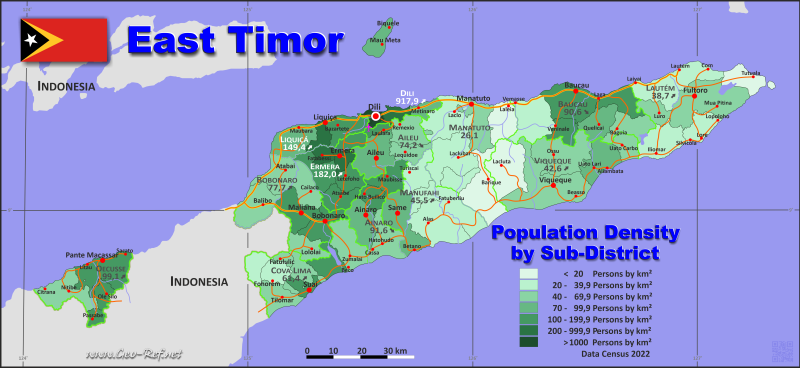
Timor Leste map - Click the map to get map as PDF file.
Other language versions are easy to generate, the descriptions are in own layers
Conditions for thematic maps with your own data and logotype
Delivery as printable file by e-mail or plot by post office
|
|---|
| Layers | |
| Provinces: | yes |
| Streets: | yes |
| Infrastructure: | yes |
| Rivers: | yes |
|
| Size | Till A2 |
| Delivery time | 7 working days | | Price |
| 1 bis 3 | 110
75 € | | > 3 | On request |
|
 |
All information published herein is free usable quoting the source,
including the maps, if they are not modified
|
|---|
Statistical data - Population density according to the administrative structure
The population data of the table below is census data from 2022, last available data.
Click on the column header brings the table in order of the column header.
The default order is the district name.
| District |
ISO
3166-2 |
Capital |
Area
(km²) |
Population |
Density
(pers/km²) |
| Total |
|
|
14 897 |
1 341 737 |
90,1 |
|---|
| Last update: 11/04/202 - 00:44:03 |
|---|
| Aileu |
TL-AL |
Aileu |
732 |
54 324 |
74,2 |
| Ainaro |
TL-AN |
Ainaro |
798 |
73 115 |
91,6 |
| Baucau |
TL-BA |
Baucau |
1 489 |
134 878 |
90,6 |
| Bobonaro |
TL-BO |
Bobonaro |
1 372 |
106 639 |
77,7 |
| Cova Lima |
TL-CO |
Cova Lima |
1 204 |
73 933 |
61,4 |
| Dili |
TL-DI |
Dili |
365 |
335 033 |
917,9 |
| Ermera |
TL-ER |
Gleno |
757 |
137 750 |
182,0 |
| Lautém |
TL-LA |
Lospalos |
1 811 |
70 022 |
38,7 |
| Liquiçá |
TL-LI |
Liquiçá |
560 |
83 658 |
149,4 |
| Manatuto |
TL-MT |
Manatuto |
1 781 |
50 859 |
28,6 |
| Manufahi |
TL-MF |
Same |
1 334 |
60 665 |
45,5 |
| Oecusse |
TL-OE |
Pante Macassar |
814 |
80 685 |
99,1 |
| Viqueque |
TL-VI |
Viqueque |
1 880 |
80 176 |
42,6 |
The next table shows the
structure of the districts into sub-districts,
using instead of the ISO-code the HASC-code. The
ISO-code is not defined for the sub-district
level. For more information on the HASC code
consult please www.statoids.com.
| Sub-district |
ISO
3166-2 |
District |
Capital
| Area
(km²) |
Population |
Density
(pers/km²) |
| Total |
|
|
|
14 897 |
1 341 737 |
90,1 |
|---|
| Last update: 11/04/202 - 00:44:03 |
|---|
| Aileu |
AL-AI |
Aileu |
Aileu |
324 |
26 208 |
80,9 |
| Ainaro |
AN-AI |
Ainaro |
Ainaro |
234 |
17 786 |
76,0 |
| Alas |
MF-AL |
Manufahi |
Alas |
406 |
9 532 |
23,5 |
| Atabae |
BB-AT |
Bobonaro |
Aidabaleten |
250 |
12 938 |
51,8 |
| Atauro |
DL-AT |
Dili |
Atauro |
140 |
10 295 |
73,5 |
| Atsabe |
ER-AT |
Ermera |
Atsabe |
165 |
19 826 |
120,2 |
| Baguia |
BC-BG |
Baucau |
Baguia |
216 |
11 718 |
54,3 |
| Balibo |
BB-BA |
Bobonaro |
Balibo |
298 |
17 619 |
59,1 |
| Barique |
MT-BN |
Manatuto |
Barique |
397 |
6 164 |
15,5 |
| Baucau |
BC-BC |
Baucau |
Baucau |
369 |
54 964 |
149,0 |
| Bazartete |
LQ-BA |
Liquiçá |
Bazartete |
197 |
33 442 |
169,8 |
| Bobonaro |
BB-BO |
Bobonaro |
Bobonaro |
207 |
25 374 |
122,6 |
| Cailaco |
BB-CA |
Bobonaro |
Marko |
205 |
10 328 |
50,4 |
| Cristo Rei |
DL-CR |
Dili |
Dili |
83 |
76 369 |
920,1 |
| Dom Aleixo |
DL-DA |
Dili |
Dili |
28 |
165 799 |
5 921,4 |
| Ermera |
ER-ER |
Ermera |
Ermera |
92 |
40 294 |
438,0 |
| Fatuberlio |
MF-FA |
Manufahi |
Welaluhu |
375 |
8 490 |
22,6 |
| Fatululic |
CL-FL |
Cova Lima |
Fatululic |
47 |
2 178 |
46,3 |
| Fatumean |
CL-FM |
Cova Lima |
Fatumean |
128 |
3 648 |
28,5 |
| Fohorem |
CL-FO |
Cova Lima |
Fohoren |
132 |
4 583 |
34,7 |
| Hato-Builico |
AN-HB |
Ainaro |
Hatu-Builico |
118 |
15 134 |
128,3 |
| Hato-Udo |
ER-HA |
Ainaro |
Hato-Udo |
257 |
11 618 |
45,2 |
| Hatulia A |
- |
Ermera |
Hatolia Vila |
196 |
20 285 |
103,5 |
| Hatulia B |
AN-HU |
Ermera |
Fatubessi |
79 |
21 479 |
271,9 |
| Iliomar |
BT-IL |
Lautém |
Iliomar |
293 |
6 569 |
22,4 |
| Laclo |
MT-LO |
Manatuto |
Laclo |
359 |
9 856 |
27,5 |
| Laclubar |
MT-LB |
Manatuto |
Laclubar |
408 |
12 173 |
29,8 |
| Lacluta |
VQ-LA |
Viqueque |
Dilor |
413 |
6 695 |
16,2 |
| Laga |
BC-LA |
Baucau |
Laga |
192 |
19 781 |
103,0 |
| Laleia |
MT-LL |
Manatuto |
Laleia |
226 |
4 192 |
18,5 |
| Laulara |
AL-LA |
Aileu |
Laulara |
56 |
7 022 |
125,4 |
| Lautém |
BT-LA |
Lautém |
Lautém |
452 |
17 677 |
39,1 |
| Lequidoe |
AL-LE |
Aileu |
Lequidoe |
138 |
7 800 |
56,5 |
| Letefoho |
ER-LE |
Ermera |
Letefoho |
133 |
22 064 |
165,9 |
| Liquiçá |
LQ-LI |
Liquiçá |
Vila de Liquiçá |
95 |
26 418 |
278,1 |
| Lolotoe |
BB-LO |
Bobonaro |
Lolotoe |
170 |
7 691 |
45,2 |
| Lore |
- |
Lautém |
Lore |
173 |
3 692 |
21,3 |
| Lospalos |
BT-LO |
Lautém |
Lospalos |
562 |
30 044 |
53,5 |
| Luro |
BT-LU |
Lautém |
Luro |
132 |
8 381 |
63,5 |
| Maliana |
BB-MA |
Bobonaro |
Maliana |
242 |
32 689 |
135,1 |
| Manatuto |
MT-MA |
Manatuto |
Manatuto |
259 |
15 197 |
58,7 |
| Maubara |
LQ-MA |
Liquiçá |
Maubara |
268 |
23 798 |
88,8 |
| Maubisse |
AN-MA |
Ainaro |
Maubisse |
189 |
28 577 |
151,2 |
| Maucatar |
CL-MA |
Cova Lima |
Holpilat |
156 |
10 793 |
69,2 |
| Metinaro |
DL-ME |
Dili |
Metinaro |
84 |
7 169 |
85,3 |
| Nain Feto |
DL-NF |
Dili |
Dili |
6 |
33 528 |
5 588,0 |
| Nitibe |
AM-NI |
Oecusse |
Citrana |
299 |
13 496 |
45,1 |
| Oesilo |
AM-OE |
Oecusse |
Oesilo |
97 |
12 637 |
130,3 |
| Ossu |
VQ-OS |
Viqueque |
Ossu |
431 |
18 787 |
43,6 |
| Pante Macassar |
AM-PM |
Oecusse |
Pante Macassar |
358 |
45 415 |
126,9 |
| Passabe |
AM-PA |
Oecusse |
Passabe |
60 |
9 137 |
152,3 |
| Quelicai |
BC-QU |
Baucau |
Quelicai |
211 |
18 444 |
87,4 |
| Railaco |
ER-RA |
Ermera |
Railaco |
92 |
13 802 |
150,0 |
| Remexio |
AL-RE |
Aileu |
Remexio |
214 |
13 294 |
62,1 |
| Same |
MF-SA |
Manufahi |
Same |
356 |
34 843 |
97,9 |
| Soibada |
MT-SO |
Manatuto |
Soibada |
132 |
3 277 |
24,8 |
| Suai |
CL-SU |
Cova Lima |
Suai |
258 |
26 644 |
103,3 |
| Tilomar |
CL-TI |
Cova Lima |
Tilomar |
197 |
9 977 |
50,6 |
| Turiscai |
MF-TU |
Manufahi |
Turiscai |
197 |
7 800 |
39,6 |
| Tutuala |
BT-TU |
Lautém |
Tutuala |
199 |
3 659 |
18,4 |
| Uato-Lari |
VQ-UL |
Viqueque |
Uato-Lari |
251 |
18 459 |
73,5 |
| Uatucarbau |
VQ-UC |
Viqueque |
Uatucarbau |
130 |
7 879 |
60,6 |
| Vemasse |
BC-VM |
Baucau |
Vemasse |
361 |
11 206 |
31,0 |
| Venilale |
BC-VL |
Baucau |
Venilale |
140 |
18 765 |
134,0 |
| Vera Cruz |
-DL-VC |
Dili |
Dili |
24 |
41 873 |
1 744,7 |
| Viqueque |
VQ-VI |
Viqueque |
Viqueque |
655 |
28 356 |
43,3 |
| Zumalai |
CL-MZ |
Cova Lima |
Zumalai |
286 |
16 110 |
56,3 |
Existing thematic maps
|
External links change quickly - If you get a link error - Please inform us!
 |
Membership in international organisations and treaties
Expand list
Political Alliances
Regional Unions
Military alliances/Arms control
Law enforcement
Business Alliances
Fishery
Financial
Free Trade Area, Internal Market
Technical alliances
Environment
Transport
Cientific
Humanitarian Unions
Cultural Unions
|
|
If you have suggestions to include other information or you find missed links, please inform us!
Click here ... |
International Border disputes
Expand list
See also neighboring states
|
| |


