Lao People's Democratic Republic
| Capital |
Currency | Government system |
|---|
| Vientiane |
Kip (LAK) |
One-party system |
| Official language | Region |
Population |
|---|
| Lao |
Far East |
Estimation 2020
7 231 210 |
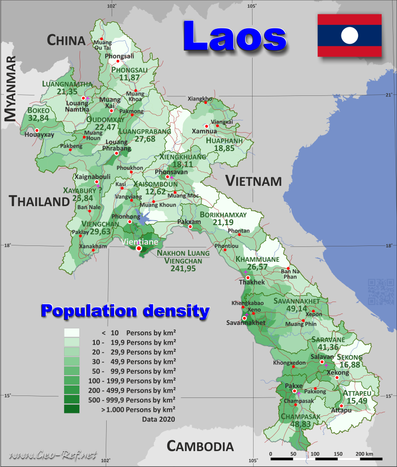
Country map - Administrative structure - Population density of Laos
Laos map - Click the map to get map as PDF file.
Other language versions are easy to generate, the descriptions are in own layers
Conditions for thematic maps with your own data and logotype
Delivery as printable file by e-mail or plot by post office
|
|---|
| Layers | |
| Provinces: | yes |
| Streets: | yes |
| Infrastructure: | yes |
| Rivers: | yes |
|
| Size | Till A2 |
| Delivery time | 7 working days | | Price |
| 1 bis 3 | 65 € | | > 3 | On request |
|
 |
All information published herein is free usable quoting the source,
including the maps, if they are not modified
|
|---|
Statistical data - Population density according to the administrative structure
The population data of the table below is an estimation form 2020, based on the census 2015.
Click on the column header brings the table in order of the column header.
The default order is the province name.
| Province |
ISO
3166-2 |
Capital |
Area
(km²) |
Population |
Density
(pers/km²) |
| Total |
|
|
227 986 |
7 231 210 |
31,72 |
|---|
| Last update: 11/04/202 - 00:44:02 |
|---|
| Attapeu |
LA-AT |
Attapeu |
10 237 |
159 886 |
15,62 |
| Bokeo |
LA-BK |
Huay Xay |
6 812 |
203 468 |
29,87 |
| Bolikhamsai |
LA-BL |
Pakxan |
12 813 |
314 957 |
24,58 |
| Champasak |
LA-CH |
Pakxé |
14 896 |
752 683 |
50,53 |
| Houaphan |
LA-HO |
Sam Neua |
17 194 |
310 979 |
18,09 |
| Khammuan |
LA-KH |
Thakhek |
16 736 |
433 570 |
25,91 |
| Luang Namtha |
LA-LM |
Luang Namtha |
9 498 |
199 091 |
20,96 |
| Luang Prabang |
LA-LP |
Luang Prabang |
19 949 |
467 157 |
23,42 |
| Oudomsai |
LA-OU |
Muang Xay |
12 080 |
345 424 |
28,59 |
| Phongsali |
LA-PH |
Phongsali |
15 513 |
193 149 |
12,45 |
| Salavan |
LA-SL |
Salavan |
10 108 |
442 230 |
43,75 |
| Savannakhet |
LA-SV |
Savannakhet |
21 292 |
1 070 031 |
50,26 |
| Sayaburi |
LA-XA |
Muang Sayaburi |
15 538 |
423 492 |
27,26 |
| Saysomboun |
LA-XS |
Anouvong |
7 958 |
107 927 |
13,56 |
| Sekong |
LA-XE |
Ban Phone |
8 285 |
129 399 |
15,62 |
| Vientiane |
LA-VI |
Vientiane |
3 641 |
948 446 |
260,49 |
| Vientiane (Province) |
LA-VT |
Muang Phon-Hong |
12 514 |
462 139 |
36,93 |
| Xiengkhouang |
LA-XI |
Phonsavan |
12 922 |
267 182 |
20,68 |
The provinces are subdivided into districts, and their data can be found in the following table.shown in the next table.
| District |
HASC |
Province |
Capital
| Area
(km²) |
Population |
Density
(pers/km²) |
| Total |
|
|
|
227 986 |
7 231 210 |
31,7 |
|---|
| Last update: 11/04/202 - 00:44:02 |
|---|
| Anouvong |
n.d. |
Xaisomboun |
Anouvong |
2 068 |
29 733 |
14,4 |
| Assaphone |
SV.AP |
Savannakhet |
Assaphone |
1 482 |
64 722 |
43,7 |
| Atsaphangthong |
SV.AT |
Savannakhet |
Atsaphangthong |
673 |
50 210 |
74,6 |
| Bachiangchaleunsook |
CH.BA |
Champasack |
Bachiangchaleunsook |
873 |
63 586 |
72,8 |
| Beng |
OU.BE |
Oudomxay |
Beng |
1 665 |
41 662 |
25,0 |
| Borikhanh |
BL.BO |
Borikhamxay |
Borikhanh |
2 560 |
57 959 |
22,6 |
| Botene |
XA.BO |
Xayabury |
Botene |
1 094 |
17 801 |
16,3 |
| Boualapha |
KH.BU |
Khammuane |
Boualapha |
3 251 |
37 023 |
11,4 |
| Boun Neua |
PH.BN |
Phongsaly |
Boun Neua |
1 184 |
25 018 |
21,1 |
| Boun Tay |
PH.BT |
Phongsaly |
Boun Tay |
1 374 |
28 310 |
20,6 |
| Champasack |
CH.CH |
Champasack |
Champasack |
895 |
66 978 |
74,8 |
| Champhone |
SV.CH |
Savannakhet |
Champhone |
1 065 |
116 656 |
109,5 |
| Chanthabuly |
VT.CH |
Vientiane |
Chanthabuly |
26 |
77 256 |
2 971,4 |
| Chomphet |
LP.CH |
Luangprabang |
Chomphet |
1 333 |
32 260 |
24,2 |
| Dakcheung |
XE.DA |
Sekong |
Dakcheung |
2 575 |
26 499 |
10,3 |
| Et |
HO.MU |
Huaphanh |
Et |
1 026 |
28 481 |
27,8 |
| Feuang |
VN.FE |
Viengchan |
Feuang |
868 |
46 196 |
53,2 |
| Hadxaifong |
VT.HA |
Vientiane |
Hadxaifong |
225 |
111 044 |
493,5 |
| Hiem |
n.d. |
Huaphanh |
Hiem |
1 409 |
13 207 |
9,4 |
| Hineboune |
KH.HI |
Khammuane |
Hineboune |
1 885 |
55 036 |
29,2 |
| Hinhurp |
VN.HI |
Viengchan |
Hinhurp |
150 |
32 288 |
215,3 |
| Hom |
XS.HO |
Xaisomboun |
Hom |
1 282 |
13 541 |
10,6 |
| Hongsa |
XA.HO |
Xayabury |
Hongsa |
1 508 |
30 730 |
20,4 |
| Houameuang |
HO.HU |
Huaphanh |
Houameuang |
2 417 |
35 215 |
14,6 |
| Houne |
OU.HO |
Oudomxay |
Houne |
2 097 |
83 734 |
39,9 |
| Huoixai |
BK.HO |
Bokeo |
Huoixai |
1 730 |
78 246 |
45,2 |
| Kaleum |
XE.KA |
Sekong |
Kaleum |
3 361 |
20 240 |
6,0 |
| Kasy |
VN.KA |
Viengchan |
Kasy |
2 459 |
41 528 |
16,9 |
| Kaysone Phomvihane |
n.d. |
Savannakhet |
Kaysone Phomvihane |
651 |
136 583 |
209,8 |
| Kenethao |
XA.KE |
Xayabury |
Kenethao |
1 250 |
42 930 |
34,3 |
| Keooudom |
VN.KE |
Viengchan |
Keooudom |
514 |
18 981 |
36,9 |
| Kham |
XK.KM |
Xiengkhuang |
Kham |
2 099 |
51 087 |
24,3 |
| Khamkheuth |
BL.KH |
Borikhamxay |
Khamkheuth |
2 624 |
71 209 |
27,1 |
| Khong |
CH.KH |
Champasack |
Khong |
1 948 |
100 537 |
51,6 |
| Khongxedone |
SL.KH |
Saravane |
Khongxedone |
794 |
67 444 |
84,9 |
| Khop |
XA.KH |
Xayabury |
Khop |
696 |
23 726 |
34,1 |
| Khoua |
n.d. |
Phongsaly |
Khoua |
1 688 |
27 421 |
16,2 |
| Khoune |
XK.KN |
Xiengkhuang |
Khoune |
1 763 |
36 574 |
20,7 |
| Khounkham |
n.d. |
Khammuane |
Khounkham |
1 063 |
24 862 |
23,4 |
| Kuan |
PH.KH |
Huaphanh |
Kuan |
1 386 |
27 404 |
19,8 |
| La |
OU.LA |
Oudomxay |
La |
1 210 |
18 801 |
15,5 |
| Lakhonepheng |
SL.LK |
Saravane |
Lakhonepheng |
1 282 |
52 934 |
41,3 |
| Lam Mam |
XE.LA |
Sekong |
Lam Mam |
1 686 |
39 354 |
23,3 |
| Lao Ngam |
SL.LN |
Saravane |
Lao Ngam |
902 |
79 978 |
88,7 |
| Long |
LM.LO |
Luangnamtha |
Long |
2 536 |
40 124 |
15,8 |
| Longchaeng |
n.d. |
Xaisomboun |
Longchaeng |
1 391 |
11 710 |
8,4 |
| Longxan |
n.d. |
Xaisomboun |
Longxan |
1 946 |
28 359 |
14,6 |
| Luangprabang |
LP.LO |
Luangprabang |
Luangprabang |
788 |
98 080 |
124,5 |
| Mad |
VN.MA |
Viengchan |
Mad |
1 562 |
23 085 |
14,8 |
| Mahaxay |
KH.MA |
Khammuane |
Mahaxay |
1 405 |
40 983 |
29,2 |
| May |
PH.MA |
Phongsaly |
May |
2 752 |
28 932 |
10,5 |
| Mayparkngeum |
VT.MA |
Vientiane |
Mayparkngeum |
650 |
55 412 |
85,2 |
| Meun |
n.d. |
Viengchan |
Meun |
1 076 |
46 652 |
43,4 |
| Meung |
BK.ME |
Bokeo |
Meung |
1 601 |
17 004 |
10,6 |
| Moonlapamok |
CH.MO |
Champasack |
Moonlapamok |
2 315 |
43 588 |
18,8 |
| Morkmay |
XK.MO |
Xiengkhuang |
Morkmay |
2 068 |
16 277 |
7,9 |
| Nakay |
KH.NA |
Khammuane |
Nakay |
4 404 |
28 992 |
6,6 |
| Nalae |
LM.NL |
Luangnamtha |
Nalae |
1 710 |
26 071 |
15,2 |
| Nambak |
LP.NM |
Luangprabang |
Nambak |
1 936 |
75 742 |
39,1 |
| Namor |
OU.NA |
Oudomxay |
Namor |
1 743 |
44 141 |
25,3 |
| Namtha |
LM.NT |
Luangnamtha |
Namtha |
2 079 |
60 870 |
29,3 |
| Nan |
LP.NN |
Luangprabang |
Nan [Nane] |
1 441 |
29 630 |
20,6 |
| Naxaithong |
VT.NA |
Vientiane |
Naxaithong |
901 |
88 298 |
98,0 |
| Nga |
OU.NG |
Oudomxay |
Nga |
1 961 |
35 893 |
18,3 |
| Ngeun |
XA.NG |
Xayabury |
Ngeun |
735 |
20 287 |
27,6 |
| Ngoy |
LP.NG |
Luangprabang |
Ngoy |
1 933 |
31 077 |
16,1 |
| Nhommalath |
KH.NH |
Khammuane |
Nhommalath |
1 525 |
37 187 |
24,4 |
| Nhot Ou |
PH.NH |
Phongsaly |
Nhot Ou |
3 041 |
33 303 |
11,0 |
| Nong |
SV.NO |
Savannakhet |
Nong |
1 833 |
34 362 |
18,7 |
| Nongbok |
KH.NO |
Khammuane |
Nongbok |
347 |
50 799 |
146,4 |
| Nonghet |
XK.NO |
Xiengkhuang |
Nonghet |
2 269 |
41 002 |
18,1 |
| Outhoumphone |
SV.OU |
Savannakhet |
Outhoumphone |
1 014 |
100 061 |
98,7 |
| Pak Ou |
LP.PO |
Luangprabang |
Pak Ou |
883 |
28 066 |
31,8 |
| Pak Xeng |
LP.PX |
Luangprabang |
Pak Xeng |
1 655 |
23 248 |
14,0 |
| Pakbeng |
OU.PA |
Oudomxay |
Pakbeng |
1 273 |
33 072 |
26,0 |
| Pakkading |
BL.PD |
Borikhamxay |
Pakkading |
1 961 |
57 824 |
29,5 |
| Paktha |
BK.PA |
Bokeo |
Paktha |
895 |
21 849 |
24,4 |
| Pakxane |
BL.PS |
Borikhamxay |
Pakxane |
602 |
51 078 |
84,8 |
| Pakxe |
CH.PE |
Champasack |
Pakxe |
127 |
80 944 |
637,4 |
| Pakxong |
CH.PG |
Champasack |
Pakxong |
3 352 |
93 084 |
27,8 |
| Parklai |
XA.PA |
Xayabury |
Parklai |
2 234 |
74 834 |
33,5 |
| Pathoomphone |
CH.PT |
Champasack |
Pathoomphone |
2 423 |
68 108 |
28,1 |
| Pek |
XK.PE |
Xiengkhuang |
Pek |
1 257 |
83 006 |
66,0 |
| Pha Oudom |
BK.PH |
Bokeo |
Pha Oudom |
1 708 |
46 849 |
27,4 |
| Phalanxay |
n.d. |
Savannakhet |
Phalanxay |
1 047 |
45 375 |
43,3 |
| Phaxay |
XK.PX |
Xiengkhuang |
Phaxay |
979 |
12 790 |
13,1 |
| Phiang |
XA.PH |
Xayabury |
Phiang |
2 809 |
64 715 |
23,0 |
| Phine |
SV.PH |
Savannakhet |
Phine |
3 299 |
74 792 |
22,7 |
| Phongsaly |
PH.PH |
Phongsaly |
Phongsaly |
2 855 |
24 032 |
8,4 |
| Phonhong |
VN.PH |
Viengchan |
Phonhong |
586 |
70 843 |
120,9 |
| Phonthong |
LP.PH |
Luangprabang |
Phonthong |
2 091 |
21 498 |
10,3 |
| Phonthong |
CH.PH |
Champasack |
Phonthong |
937 |
100 291 |
107,0 |
| Phonxay |
n.d. |
Luangprabang |
Phonxay |
2 591 |
35 763 |
13,8 |
| Phoukhoune |
LP.PK |
Luangprabang |
Phoukhoune |
1 665 |
26 190 |
15,7 |
| Phoukout |
n.d. |
Xiengkhuang |
Phoukout |
2 487 |
26 446 |
10,6 |
| Phouvong |
AT.PH |
Attapeu |
Phouvong |
3 391 |
16 511 |
4,9 |
| Sa Mouay |
n.d. |
Saravane |
Sa Mouay |
630 |
18 976 |
30,1 |
| Samakkhixai |
AT.SK |
Attapeu |
Samakkhixai |
492 |
41 040 |
83,4 |
| Samphanh |
PH.SA |
Phongsaly |
Samphanh |
2 619 |
26 133 |
10,0 |
| Sanamxai |
AT.SN |
Attapeu |
Sanamxai |
2 217 |
39 116 |
17,6 |
| Sanasomboon |
CH.SA |
Champasack |
Sanasomboon |
901 |
71 834 |
79,7 |
| Sangthong |
VT.SA |
Vientiane |
Sangthong |
700 |
34 024 |
48,6 |
| Sanxai |
AT.SX |
Attapeu |
Sanxai |
2 841 |
25 823 |
9,1 |
| Saravane |
SL.SV |
Saravane |
Saravane |
2 063 |
111 474 |
54,0 |
| Seponh |
SV.SE |
Savannakhet |
Seponh |
2 097 |
65 147 |
31,1 |
| Sikhottabong |
VT.SK |
Vientiane |
Sikhottabong |
146 |
138 655 |
949,7 |
| Sing |
LM.SI |
Luangnamtha |
Sing |
1 336 |
44 660 |
33,4 |
| Sisattanak |
VT.SS |
Vientiane |
Sisattanak |
26 |
73 610 |
2 831,2 |
| Songkhone |
SV.SO |
Savannakhet |
Songkhone |
1 385 |
108 140 |
78,1 |
| Sopbao |
HO.SO |
Huaphanh |
Sopbao |
1 033 |
27 075 |
26,2 |
| Sukhuma |
CH.SU |
Champasack |
Sukhuma |
1 125 |
63 733 |
56,7 |
| Ta Oy |
SL.TA |
Saravane |
Ta Oy |
2 510 |
37 658 |
15,0 |
| Thakhek |
KH.TH |
Khammuane |
Thakhek |
989 |
97 542 |
98,6 |
| Thapangthong |
SV.TT |
Savannakhet |
Thapangthong |
2 116 |
46 941 |
22,2 |
| Thaphabath |
BL.TH |
Borikhamxay |
Thaphabath |
1 522 |
28 699 |
18,9 |
| Thateng |
XE.TH |
Sekong |
Thateng |
663 |
43 306 |
65,3 |
| Thathom |
XS.TH |
Xaisomboun |
Thathom |
1 271 |
24 584 |
19,3 |
| Thongmyxay |
XA.TH |
Xayabury |
Thongmyxay |
883 |
9 242 |
10,5 |
| Thoulakhom |
VN.TH |
Viengchan |
Thoulakhom |
783 |
57 791 |
73,8 |
| Tonpheung |
BK.TO |
Bokeo |
Tonpheung |
878 |
39 520 |
45,0 |
| Toumlane |
SL.TO |
Saravane |
Toumlane |
749 |
32 827 |
43,8 |
| Vangvieng |
VN.VA |
Viengchan |
Vangvieng |
1 436 |
61 314 |
42,7 |
| Vapy |
SL.VA |
Saravane |
Vapy |
1 178 |
40 939 |
34,8 |
| Viengkham |
LP.VI |
Luangprabang |
Viengkham |
2 038 |
30 116 |
14,8 |
| Viengkham |
VN.VI |
Viengchan |
Viengkham |
1 192 |
19 959 |
16,7 |
| Viengphoukha |
LM.VI |
Luangnamtha |
Viengphoukha |
1 837 |
27 366 |
14,9 |
| Viengthong |
HO.VT |
Borikhamxay |
Viengthong |
1 408 |
35 122 |
24,9 |
| Viengxay |
HO.VX |
Huaphanh |
Viengxay |
1 536 |
33 251 |
21,6 |
| Vilabuly |
SV.VI |
Savannakhet |
Vilabuly |
1 756 |
44 714 |
25,5 |
| Xaisathan |
n.d. |
Xayabury |
Xaisathan |
884 |
17 106 |
19,4 |
| Xamneua |
HO.XN |
Huaphanh |
Xamneua |
3 158 |
61 654 |
19,5 |
| Xamtay |
HO.XT |
Huaphanh |
Xamtay |
2 378 |
39 698 |
16,7 |
| Xanakharm |
VN.XA |
Viengchan |
Xanakharm |
1 888 |
43 502 |
23,0 |
| Xay |
OU.XA |
Oudomxay |
Xay |
2 131 |
88 121 |
41,4 |
| Xayabury |
XA.XA |
Xayabury |
Xayabury |
2 263 |
85 468 |
37,8 |
| Xaybuathong |
KH.XA |
Khammuane |
Xaybuathong |
923 |
29 614 |
32,1 |
| Xaybuly |
SV.XB |
Savannakhet |
Xaybuly |
913 |
65 738 |
72,0 |
| Xaychomphone |
BL.XC |
Borikhamxay |
Xaychomphone |
2 136 |
13 066 |
6,1 |
| Xayphouthong |
SV.XP |
Savannakhet |
Xayphouthong |
588 |
50 644 |
86,1 |
| Xaysetha |
AT.XA |
Attapeu |
Xaysetha |
1 296 |
37 396 |
28,9 |
| Xaysetha |
VT.XS |
Vientiane |
Xaysetha |
134 |
135 209 |
1 009,0 |
| Xaythany |
VT.XT |
Vientiane |
Xaythany |
833 |
234 938 |
282,0 |
| Xebangfay |
KH.XE |
Khammuane |
Xebangfay |
944 |
31 532 |
33,4 |
| Xienghone |
XA.XI |
Xayabury |
Xienghone |
1 182 |
36 653 |
31,0 |
| Xiengkhor |
HO.XI |
Huaphanh |
Xiengkhor |
795 |
27 180 |
34,2 |
| Xiengngeun |
LP.XI |
Luangprabang |
Xiengngeun |
1 595 |
35 487 |
22,2 |
| Xon |
n.d. |
Huaphanh |
Xon |
2 056 |
17 814 |
8,7 |
| Xonbuly |
SV.XO |
Savannakhet |
Xonbuly |
1 373 |
65 946 |
48,0 |
Existing thematic maps
|
External links change quickly - If you get a link error - Please inform us!
 |
Membership in international organisations and treaties
Expand list
Political Alliances
Regional Unions
Military alliances/Arms control
Law enforcement
Business Alliances
Fishery
Financial
Free Trade Area, Internal Market
Technical alliances
Transport
Cientific
Humanitarian Unions
Cultural Unions
|
|
If you have suggestions to include other information or you find missed links, please inform us!
Click here ... |
International Border disputes
Expand list
See also neighboring states
|
| |


