|
Republic of Kiribati
|
 |
|
 |
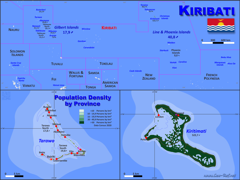
Kiribati map in English - Click the map to get map as PDF file.
|
| Size: | till A2 |
| Layer: |
| Provinces: | yes |
| Streets: | yes |
| Infrastructure: | yes |
| Rivers: | yes |
| | Observations: | | |
|
| Price for your thematic maps, done in less than 7 working days |
| 1 till 3 | 75 |
| > 4 | Consult us |
First contact for order:
servicio@geo-ref.net
|
| | |
| Other language versions are easy to generate, the descriptions are in own layers |
The population data of the table below is an estimation form 2013, last available data.
Click on the column header brings the table in order of the column header.
The default order is the
district name.
|
|
District |
ISO
3166-2 |
Island group |
Capital |
Area
(kmē) |
Population |
Density
(pers/kmē) |
| Total |
|
|
|
801 |
137 632 |
171,8 |
| Update: 30.04.2013 |
| Banaba |
KI-G |
Banaba |
Banaba |
6 |
335 |
55,8 |
| Tarawa |
KI-G |
Tarawa |
South Tarawa |
32 |
50000 |
1562,5 |
| Northern Gilbert Islands |
KI-G |
Gilbert |
|
84 |
59897 |
713,1 |
| Central Gilbert Island |
KI-G |
Gilbert |
|
91 |
10731 |
117,9 |
| Southern Gilbert Islands |
KI-G |
Gilbert |
|
67 |
7856 |
117,3 |
| Line Islands |
KI-L |
Line |
|
494 |
8813 |
17,8 |
| Phoenix Islands |
KI-P |
Phoenix |
Kanton |
27 |
- |
- |
The population by district is detailed in the next table. The
corresponding ISO data could not be localized.
| Province |
Capital |
Area
(kmē) |
Population |
Density
(pers/kmē) |
| Total |
|
6 363 |
104 432 |
16,4 |
| Update: 30.04.2013 |
| Abaiang |
Taburao |
411 |
6 571 |
16,0 |
| Abemana |
Binoinano |
109 |
3 039 |
27,8 |
| Aranuka |
Takaeang |
62 |
956 |
15,5 |
| Arorae |
Roreti |
127 |
1 202 |
9,5 |
| Banaba |
Ooma |
55 |
349 |
6,3 |
| Beru |
Tabukiniberu |
188 |
2 764 |
14,7 |
| Butaritari |
Butaritari |
227 |
3 086 |
13,6 |
| Kiritimati |
London |
14 |
5 133 |
363,5 |
| Kuria |
Tabontebike |
80 |
980 |
12,3 |
| Maiana |
Tabiauea |
123 |
1 959 |
15,9 |
| Makin |
Makin |
240 |
1 610 |
6,7 |
| Marakei |
Rawannawi |
174 |
2 348 |
13,5 |
| Nikunau |
Rungata |
84 |
1 524 |
18,2 |
| Nonouti |
Temaraia |
130 |
3 806 |
29,2 |
| Onotoa |
Ijaki |
99 |
1 332 |
13,5 |
| Phoenix Islands |
Pyramid Point |
2 |
67 |
28,8 |
| Tabiteuea North |
Utiroa |
142 |
3 688 |
26,0 |
| Tabiteuea South |
Buariki |
88 |
1 054 |
12,0 |
| Tabuaeran |
Nabari |
213 |
3 021 |
14,2 |
| Tamana |
Abaokoro |
147 |
703 |
4,8 |
| Tarawa North |
Buariki |
395 |
6 285 |
15,9 |
| Tarawa South |
Bairiki |
3 207 |
51 317 |
16,0 |
| Teraina |
Washington |
47 |
1 638 |
34,6 |
Useful Links
UN-Data
World Bank
Kiribati
Statistics Office
|
| |
|