Hungary
| Capital |
Currency | Government system |
|---|
| Budapest |
Forint (HUF) |
Parliamentary democracy |
| Official language | Region |
Population |
|---|
| Hungarian |
Europe |
Estimation 2025
9 539 502 |
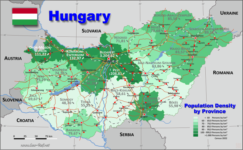
Country map - Administrative structure - Population density of Hungary
Hungary map - Click the map to get map as PDF file.
Other language versions are easy to generate, the descriptions are in own layers
Conditions for thematic maps with your own data and logotype
Delivery as printable file by e-mail or plot by post office
|
|---|
| Layers | |
| Provinces: | yes |
| Streets: | yes |
| Infrastructure: | yes |
| Rivers: | yes |
|
| Size | Till A2 |
| Delivery time | 7 working days | | Price |
| 1 bis 3 | 60 € | | > 3 | On request |
|
 |
All information published herein is free usable quoting the source,
including the maps, if they are not modified
|
|---|
Statistical data - Population density according to the administrative structure
The population data of the table below is an estimation form 2025, based on the census 2022.
Click on the column header brings the table in order of the column header.
The default order is the district name.
| District |
ISO
3166-2 |
Capital |
Area
(km²) |
Population |
Density
(pers/km²) |
| Total |
|
|
93 024 |
9 539 502 |
102,55 |
|---|
| Last update: 11/04/202 - 00:44:04 |
|---|
| Bacs-Kiskun |
HU-BK |
Kecskemet |
8 445 |
488 547 |
57,85 |
| Baranya |
HU-BE |
Pecs |
4 430 |
351 158 |
79,27 |
| Bekes |
HU-BE |
Bekescsaba |
5 630 |
307 112 |
54,55 |
| Borsod-Abauj-Zemplen |
HU-BY |
Miskolc |
7 247 |
610 927 |
84,30 |
| Budapest |
HU-BU |
- |
525 |
1 685 209 |
3 209,92 |
| Csongrad |
HU-CS |
Szeged |
4 263 |
388 106 |
91,04 |
| Fejer |
HU-FE |
Szekesfehervar |
4 358 |
418 562 |
96,04 |
| Gyor-Moson-Sopron |
HU-GS |
Gyor |
4 208 |
471 648 |
112,08 |
| Hajdu-Bihar |
HU-HB |
Debrecen |
6 211 |
520 129 |
83,74 |
| Heves |
HU-HE |
Eger |
3 637 |
282 490 |
77,67 |
| Jasz-Nagykun-Szolnok |
HU-JN |
Szolnok |
5 582 |
349 726 |
62,65 |
| Komarom-Esztergom |
HU-KE |
Tatabanya |
2 264 |
299 262 |
132,18 |
| Nograd |
HU-NO |
Salgotarjan |
2 545 |
178 815 |
70,26 |
| Pest |
HU-PS |
Budapest |
6 391 |
1 336 134 |
209,06 |
| Somogy |
HU-SO |
Kaposvar |
6 036 |
290 245 |
48,09 |
| Szabolcs-Szatmar-Bereg |
HU-SY |
Nyiregyhaza |
5 936 |
520 551 |
87,69 |
| Tolna |
HU-TO |
Szekszard |
3 703 |
204 567 |
55,24 |
| Vas |
HU-VA |
Szombathely |
3 336 |
245 598 |
73,62 |
| Veszprem |
HU-VE |
Veszprem |
4 493 |
333 345 |
74,19 |
| Zala |
HU-ZA |
Zalaegerszeg |
3 784 |
257 371 |
68,02 |
Existing thematic maps
|
External links change quickly - If you get a link error - Please inform us!
 |
Membership in international organisations and treaties
Expand list
Political Alliances
Regional Unions
Military alliances/Arms control
Law enforcement
Business Alliances
Fishery
Financial
Free Trade Area, Internal Market
Technical alliances
Transport
Cientific
Humanitarian Unions
Cultural Unions
|
|
If you have suggestions to include other information or you find missed links, please inform us!
Click here ... |
See also neighboring states
|


