Republic of Haiti
| Capital |
Currency | Government system |
|---|
| Port-au-Prince |
Gourde (HTG) |
Semi-presidential system |
| Official language | Region |
Population |
|---|
Haitian Creole
French |
Central America & Caribbean |
Estimation 2024
11 194 799 |
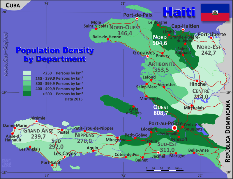
Country map - Administrative structure - Population density of Haiti
Haiti map - Click the map to get map as PDF file.
Other language versions are easy to generate, the descriptions are in own layers
Conditions for thematic maps with your own data and logotype
Delivery as printable file by e-mail or plot by post office
|
|---|
| Layers | |
| Provinces: | yes |
| Streets: | yes |
| Infrastructure: | yes |
| Rivers: | yes |
|
| Size | Till A2 |
| Delivery time | 7 working days | | Price |
| 1 bis 3 | 70 € | | > 3 | On request |
|
 |
All information published herein is free usable quoting the source,
including the maps, if they are not modified
|
|---|
Statistical data - Population density according to the administrative structure
The population data of the table below is an estimation form 2024, last available data.
Click on the column header brings the table in order of the column header.
The default order is the province name.
| Province |
ISO
3166-2 |
Capital |
Area
(km²) |
Population |
Density
(pers/km²) |
| Total |
|
|
27 066 |
11 194 799 |
413,6 |
|---|
| Last update: 01/02/2026 - 19:45:59 |
|---|
| Artibonite |
HT-AR |
Gonaives |
4 887 |
1 774 192 |
363,0 |
| Centre |
HT-CE |
Hinche |
3 487 |
766 400 |
219,8 |
| Grand´Anse |
HT-GA |
Jérémie |
1 912 |
470 700 |
246,2 |
| Nippes |
HT-NI |
Miragoane |
1 268 |
351 600 |
277,3 |
| Nord |
HT-ND |
Cap-Haitien |
2 115 |
1 095 000 |
517,7 |
| Nord-Est |
HT-NE |
Fort Liberté |
1 623 |
404 600 |
249,3 |
| Nord-Ouest |
HT-NO |
Port-de-Paix |
2 103 |
748 200 |
355,8 |
| Ouest |
HT-OU |
Port-au-Prince |
4 983 |
4 138 507 |
830,5 |
| Sud |
HT-SD |
Les Cayes |
2 654 |
795 900 |
299,9 |
| Sud-Est |
HT-SE |
Jacmel |
2 034 |
649 700 |
319,4 |
Existing thematic maps
|
External links change quickly - If you get a link error - Please inform us!
 |
Membership in international organisations and treaties
Expand list
Political Alliances
Regional Unions
Military alliances/Arms control
Law enforcement
Business Alliances
Financial
Free Trade Area, Internal Market
Technical alliances
Transport
Cientific
Humanitarian Unions
Cultural Unions
|
|
If you have suggestions to include other information or you find missed links, please inform us!
Click here ... |
International Border disputes
Expand list
Land boundaries
Maritime boundaries
See also neighboring states
|
| |


