Commonwealth of the Bahamas
| Capital |
Currency | Government system |
|---|
| Nassau |
Bahamian Dollar (BSD) |
Constitutional hereditary monarchy |
| Official language | Region |
Population |
|---|
| English |
Central America & Caribbean |
2020 - 393 580 |
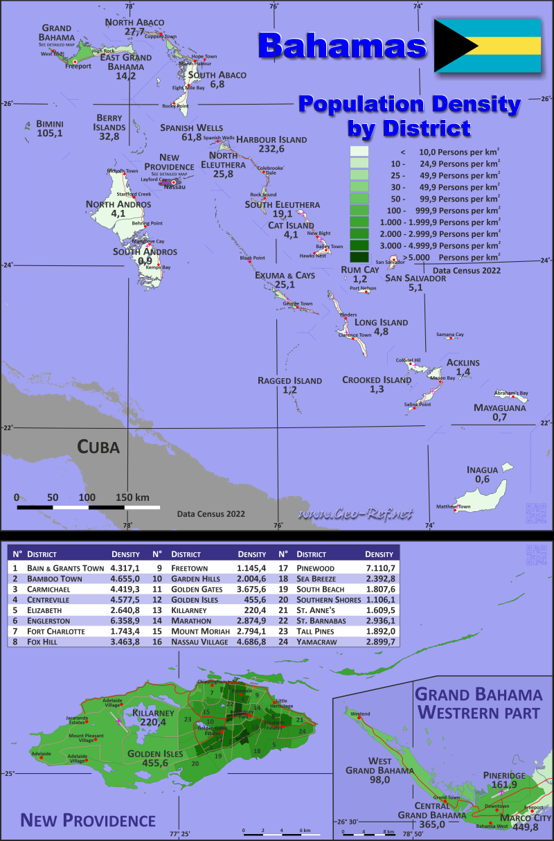
Country map - Administrative structure - Population density of Bahamas
Bahamas map - Click the map to get map as PDF file.
Other language versions are easy to generate, the descriptions are in own layers
Conditions for thematic maps with your own data and logotype
Delivery as printable file by e-mail or plot by post office
|
|---|
| Layers | |
| Provinces: | yes |
| Streets: | yes |
| Infrastructure: | yes |
| Rivers: | yes |
|
| Size | Till A2 |
| Delivery time | 7 working days | | Price |
| 1 bis 3 | 75 € | | > 3 | On request |
|
 |
All information published herein is free usable quoting the source,
including the maps, if they are not modified
|
|---|
Statistical data - Population density according to the administrative structure
The population data of the table below is census data from 2022, last available data.
Click on the column header brings the table in order of the column header.
The default order is the island - group of islands name.
| Island - Group of islands |
ISO
3166-2 |
Capital |
Area
(km²) |
Population |
Density
(pers/km²) |
| Total |
|
|
12 169,0 |
398 165 |
32,7 |
|---|
| Last update: 10.01.2025 - 22:51:58 |
|---|
| Abaco |
BS-AB |
Marsh Harbour |
1 328,3 |
16 695 |
12,6 |
| Acklins |
BS-AC |
Snug Corner |
497,0 |
676 |
1,4 |
| Andros |
BS-AN |
Nicholls Town |
5 005,9 |
7 695 |
1,5 |
| Berry Islands |
BS-BE |
Bullock's Harbour |
31,0 |
1 002 |
32,3 |
| Bimini |
BS-BI |
Alice Town |
23,0 |
2 361 |
102,7 |
| Cat Island |
BS-CA |
Arthur's Town |
388,0 |
1 570 |
4,0 |
| Crooked Island |
BS-CR |
Colonel Hill |
241,0 |
293 |
1,2 |
| Eleuthera |
BS-EL |
Governor’s Harbour |
431,0 |
9 104 |
21,1 |
| Exuma & Cays |
BS-EX |
George Town |
290,0 |
7 287 |
25,1 |
| Grand Bahama |
BS-GB |
Freeport |
969,4 |
46 740 |
48,2 |
| Harbour Island |
BS-HI |
Dunmore Town |
8,0 |
1 843 |
230,4 |
| Inagua |
BS-IN |
Matthew Town |
1 551,0 |
831 |
0,5 |
| Long Island |
BS-LI |
Clarence Town |
596,0 |
2 718 |
4,6 |
| Mayaguana |
BS-MA |
Abraham’s Bay |
285,0 |
203 |
0,7 |
| New Providence |
BS-NP |
Nassau |
221,4 |
296 732 |
1 340,3 |
| Ragged Island |
BS-RA |
Duncan Town |
36,0 |
56 |
1,6 |
| Rum Cay |
BS-RC |
Port Nelson |
78,0 |
87 |
1,1 |
| San Salvador |
BS-SS |
Cockburn Town |
163,0 |
819 |
5,0 |
| Spanish Wells |
BS-SW |
Spanish Wells |
26,0 |
1 453 |
55,9 |
List in District order
| District |
ISO
3166-2 |
Island |
Capital
| Area
(km²) |
Population |
Density
(pers/km²) |
| Total |
|
|
|
12 169,0 |
398 165 |
32,7 |
|---|
| Last update: 10.01.2025 - 22:51:58 |
|---|
| Acklins |
BS-AK |
Acklins |
Mason Bay |
497,0 |
676 |
1,4 |
| Bain and Grants Town |
BS-NP-01 |
New Providence |
Nassau |
2,4 |
10 516 |
4 381,7 |
| Bamboo Town |
BS-NP-02 |
New Providence |
Nassau |
3,0 |
14 012 |
4 670,7 |
| Berry Islands |
BS-BY |
Berry Islands |
Great Harbour |
31,0 |
1 002 |
32,3 |
| Bimini |
BS-BI |
Bimini |
Nicholls Town |
23,0 |
2 361 |
102,7 |
| Carmichael |
BS-NP-03 |
New Providence |
Nassau |
2,7 |
12 026 |
4 454,1 |
| Cat Island |
BS-CI |
Cat Island |
Alice Town |
388,0 |
1 570 |
4,0 |
| Central Grand Bahama |
BS-GB-01 |
Grand Bahama |
Freeport |
31,5 |
11 358 |
360,6 |
| Centreville |
BS-NP-04 |
New Providence |
Nassau |
2,8 |
12 929 |
4 617,5 |
| Crooked Island |
BS-CK |
Crooked Island |
The Bight |
241,0 |
293 |
1,2 |
| East Grand Bahama |
BS-EG |
Grand Bahama |
High Rock |
803,8 |
11 194 |
13,9 |
| Elizabeth |
BS-NP-05 |
New Providence |
Nassau |
5,1 |
13 407 |
2 628,8 |
| Englerston |
BS-NP-06 |
New Providence |
Nassau |
1,9 |
12 059 |
6 346,8 |
| Exuma and Cays |
BS-EX |
Exuma and Cays |
George Town |
290,0 |
7 287 |
25,1 |
| Fort Charlotte |
BS-NP-07 |
New Providence |
Nassau |
6,2 |
10 625 |
1 713,7 |
| Fox Hill |
BS-NP-08 |
New Providence |
Nassau |
4,0 |
13 803 |
3 450,8 |
| Freetown (Montagu) |
BS-NP-09 |
New Providence |
Freetown |
11,3 |
12 723 |
1 125,9 |
| Garden Hills |
BS-NP-10 |
New Providence |
Nassau |
5,2 |
10 538 |
2 026,5 |
| Golden Gates |
BS-NP-11 |
New Providence |
Nassau |
2,7 |
9 865 |
3 653,7 |
| Golden Isles |
BS-NP-12 |
New Providence |
Nassau |
35,6 |
16 651 |
467,7 |
| Harbour Island |
BS-HI |
Harbour Island |
Dunmore Town |
8,0 |
1 843 |
230,4 |
| Inagua |
BS-IN |
Inagua |
Matthew Town |
1 551,0 |
831 |
0,5 |
| Killarney |
BS-NP-13 |
New Providence |
Nassau |
80,2 |
17 455 |
217,6 |
| Long Island |
BS-LI |
Long Island |
Clarence Town |
596,0 |
2 718 |
4,6 |
| Marathon |
BS-NP-14 |
New Providence |
Nassau |
4,1 |
11 673 |
2 847,1 |
| Marco City |
BS-GB-02 |
Grand Bahama |
Marco City |
23,4 |
10 305 |
440,4 |
| Mayaguana |
BS-MG |
Mayaguana |
Abraham’s Bay |
285,0 |
203 |
0,7 |
| Mount Moriah |
BS-NP-15 |
New Providence |
Nassau |
3,7 |
10 381 |
2 805,7 |
| Nassau Village |
BS-NP-16 |
New Providence |
Nassau |
2,5 |
11 649 |
4 659,6 |
| North Abaco |
BS-NO |
Abaco |
Cooper's Town |
362,7 |
10 172 |
28,0 |
| North Andros |
BS-NS |
Andros |
St Margaret's |
981,9 |
4 029 |
4,1 |
| North Eleuthera |
BS-NE |
Eleuthera |
The Bluff |
151,8 |
3 893 |
25,6 |
| Pineridge |
BS-GB-03 |
Grand Bahama |
Pineridge |
49,9 |
7 999 |
160,3 |
| Pinewood |
BS-NP-17 |
New Providence |
Nassau |
1,5 |
10 564 |
7 042,7 |
| Ragged Island |
BS-RI |
Ragged Island |
Duncan Town |
36,0 |
56 |
1,6 |
| Rum Cay |
BS-RC |
Rum Cay |
Port Nelson |
78,0 |
87 |
1,1 |
| San Salvador |
BS-SS |
San Salvador |
Cockburn Town |
163,0 |
819 |
5,0 |
| Sea Breeze |
BS-NP-18 |
New Providence |
Nassau |
5,3 |
12 791 |
2 413,4 |
| South Abaco |
BS-SO |
Abaco |
Sandy Point |
965,6 |
6 523 |
6,8 |
| South Andros |
BS-SA |
Andros |
The Bluff |
4 024,0 |
3 666 |
0,9 |
| South Beach |
BS-NP-19 |
New Providence |
Nassau |
6,8 |
12 478 |
1 835,0 |
| South Eleuthera |
BS-SE |
Eleuthera |
Rock Sound |
279,2 |
5 211 |
18,7 |
| Southern Shores |
BS-NP-20 |
New Providence |
Nassau |
11,6 |
13 078 |
1 127,4 |
| Spanish Wells |
BS-SW |
Spanish Wells |
Spanish Wells |
26,0 |
1 453 |
55,9 |
| St Anne's |
BS-NP-21 |
New Providence |
Nassau |
8,1 |
12 783 |
1 578,1 |
| St Barnabas |
BS-NP-22 |
New Providence |
Nassau |
3,6 |
10 495 |
2 915,3 |
| Tall Pines |
BS-NP-23 |
New Providence |
Nassau |
8,0 |
15 384 |
1 923,0 |
| West Grand Bahama |
BS-WG |
Grand Bahama |
Freeport |
60,8 |
5 884 |
96,8 |
| Yamacraw |
BS-NP-24 |
New Providence |
Nassau |
3,1 |
8 847 |
2 853,9 |
Existing thematic maps
|
External links change quickly - If you get a link error - Please inform us!
 |
Membership in international organisations and treaties
Expand list
Political Alliances
Regional Unions
Military alliances/Arms control
Law enforcement
Business Alliances
Fishery
Financial
Free Trade Area, Internal Market
Technical alliances
Transport
Cientific
Humanitarian Unions
Cultural Unions
|
|
If you have suggestions to include other information or you find missed links, please inform us!
Click here ... |
International Border disputes
Expand list
See also neighboring states
|
| |


