Republic of Cape Verde
| Capital |
Currency | Government system |
|---|
| Praia |
Cape Verdean Escudo (CVE) |
Parliamentary democracy |
| Official language | Region |
Population |
|---|
| Portuguese |
Africa |
Census 2021
483 628 |
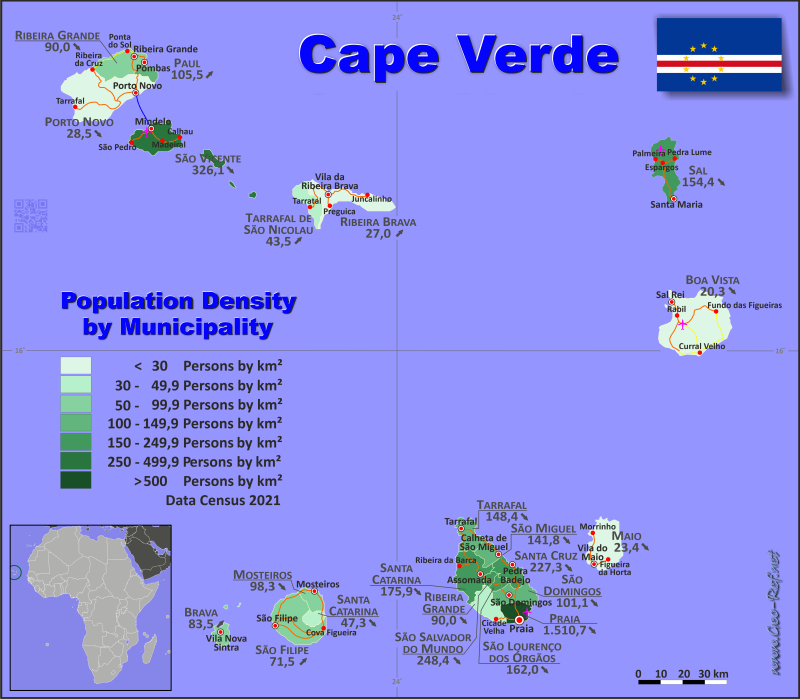
Country map - Administrative structure - Population density of Cabo Verde
Cabo Verde map - Click the map to get map as PDF file.
Other language versions are easy to generate, the descriptions are in own layers
Conditions for thematic maps with your own data and logotype
Delivery as printable file by e-mail or plot by post office
|
|---|
| Layers | |
| Provinces: | yes |
| Streets: | yes |
| Infrastructure: | yes |
| Rivers: | yes |
|
| Size | Till A2 |
| Delivery time | 7 working days | | Price |
| 1 bis 3 | 65 € | | > 3 | On request |
|
 |
All information published herein is free usable quoting the source,
including the maps, if they are not modified
|
|---|
Statistical data - Population density according to the administrative structure
The population data of the table below is census data from 2021, last available data.
Click on the column header brings the table in order of the column header.
The default order is the island name.
| Island |
ISO
3166-2 |
Capital |
Area
(km²) |
Population |
Density
(pers/km²) |
| Total |
|
|
4 020 |
483 628 |
120,3 |
|---|
| Last update: 14.03.2024 - 23:38:04 |
|---|
| Boa Vista |
CV-BVx |
Sal Rei |
620 |
12 613 |
20,3 |
| Brava |
CV-BRx |
Nova Sintra |
67 |
5 594 |
83,5 |
| Fogo |
CV-FOx |
São Filipe |
472 |
33 519 |
71,0 |
| Maio |
CV-MAx |
Cidade do Maio |
269 |
6 298 |
23,4 |
| Sal |
CV-SLx |
Espargos |
216 |
33 347 |
154,4 |
| Santiago |
CV-STx |
Praia |
991 |
269 370 |
271,8 |
| Santo Antão |
CV-SAx |
Porto Novo |
779 |
36 632 |
47,0 |
| São Nicolau |
CV-SNx |
Ribeira Brava |
379 |
12 239 |
32,3 |
| São Vicente (incl. Santa Luzia, Branco & Raso) |
CV-SVx |
Mindelo |
227 |
74 016 |
326,1 |
The country is divided into municipalities in some islands, which are shown in the following table.
| Municipality |
ISO
3166-2 |
Island |
Capital
| Area
(km²) |
Population |
Density
(pers/km²) |
| Total |
|
|
|
4 020 |
483 628 |
120,3 |
|---|
| Last update: 14.03.2024 - 23:38:04 |
|---|
| Boa Vista |
CV-BV |
Boa Vista |
Sal Rei |
620 |
12 613 |
20,3 |
| Brava |
CV-BR |
Brava |
Nova Sintra |
67 |
5 594 |
83,5 |
| Maio |
CV-MA |
Maio |
Cidade do Maio |
269 |
6 298 |
23,4 |
| Mosteiros |
CV-MO |
Fogo |
Mosteiros |
82 |
8 062 |
98,3 |
| Paul |
CV-PA |
Santo Antão |
Vila das Pombas |
54 |
5 696 |
105,5 |
| Porto Novo |
CV-PN |
Santo Antão |
Porto Novo |
558 |
15 914 |
28,5 |
| Praia |
CV-PR |
Santiago |
Praia |
94 |
142 009 |
1 510,7 |
| Ribeira Brava |
CV-RB |
São Nicolau |
Ribeira Brava |
258 |
6 978 |
27,0 |
| Ribeira Grande |
CV-RG |
Santo Antão |
Ribeira Grande |
167 |
15 022 |
90,0 |
| Ribeira Grande de Santiago |
CV-RS |
Santiago |
Cidade Velha |
164 |
7 632 |
46,5 |
| Sal |
CV-SL |
Sal |
Espargos |
216 |
33 347 |
154,4 |
| Santa Catarina |
CV-CA |
Santiago |
Assomada |
213 |
37 472 |
175,9 |
| Santa Catarina do Fogo |
CV-CF |
Fogo |
Cova Figueira |
100 |
4 725 |
47,3 |
| Santa Cruz |
CV-CR |
Santiago |
Pedra Badejo |
110 |
25 004 |
227,3 |
| São Domingos |
CV-SD |
Santiago |
São Domingos |
138 |
13 958 |
101,1 |
| São Filipe |
CV-SF |
Fogo |
São Filipe |
290 |
20 732 |
71,5 |
| São Lourenço dos Órgãos |
CV-SO |
Santiago |
João Teves |
39 |
6 317 |
162,0 |
| São Miguel |
CV-CS |
Santiago |
Calheta de São Miguel |
91 |
12 906 |
141,8 |
| São Salvador do Mundo |
CV-SS |
Santiago |
Picos |
30 |
7 452 |
248,4 |
| São Vicente |
CV-SV |
São Vicente |
Mindelo |
227 |
74 016 |
326,1 |
| Tarrafal |
CV-TA |
Santiago |
Tarrafal |
112 |
16 620 |
148,4 |
| Tarrafal de São Nicolau |
CV-TS |
São Nicolau |
Tarrafal de São Nicolau |
121 |
5 261 |
43,5 |
Existing thematic maps
|
External links change quickly - If you get a link error - Please inform us!
 |
Membership in international organisations and treaties
Expand list
Political Alliances
Regional Unions
Military alliances/Arms control
Law enforcement
Business Alliances
Fishery
Financial
Free Trade Area, Internal Market
Technical alliances
Transport
Cientific
Humanitarian Unions
Cultural Unions
|
|
If you have suggestions to include other information or you find missed links, please inform us!
Click here ... |
See also neighboring states
|


