Democratic Federation of Northern Syria
Country map - Administrative structure - Population density of Rojava
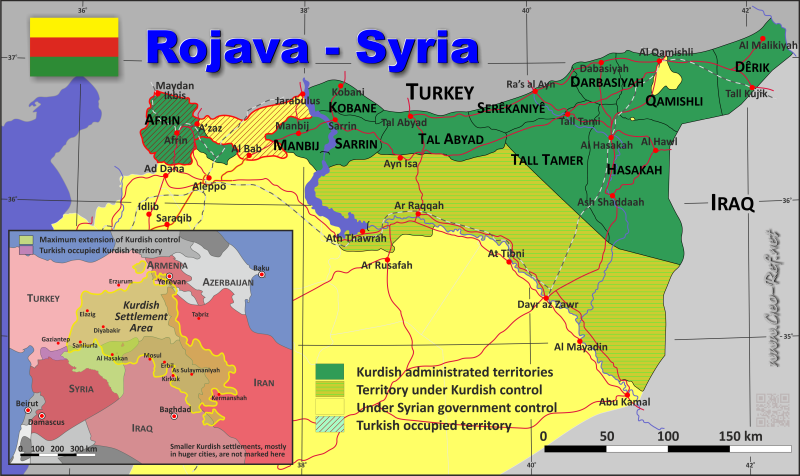
Rojava map - Click the map to get map as PDF file.
Other language versions are easy to generate, the descriptions are in own layers
Conditions for thematic maps with your own data and logotype
Delivery as printable file by e-mail or plot by post office
|
|---|
| Layers | |
| Provinces: | yes |
| Streets: | yes |
| Infrastructure: | yes |
| Rivers: | yes |
|
| Size | Till A2 |
| Delivery time | 7 working days | | Price |
| 1 bis 3 | 60 € | | > 3 | On request |
|
 |
All information published herein is free usable quoting the source,
including the maps, if they are not modified
|
|---|
Statistical data - Population density according to the administrative structure
The population data of the table below is an estimation form 2024, last available data.
Click on the column header brings the table in order of the column header.
The default order is the canton name.
| Canton |
ISO
3166-2 |
Capital |
Area
(km²) |
Population |
Density
(pers/km²) |
| Total |
|
|
57.500 |
4.933.000 |
85,8 |
|---|
| Last update: 12/16/2025 - 21:49:09 |
|---|
| Afrin |
ROJ-03 |
Afrin |
3.000 |
450.000 |
150,0 |
| Deir ez-Zor |
ROJ-07 |
Deir ez-Zor |
17.000 |
1.000.000 |
58,8 |
| Jazira |
ROJ-01 |
Al Qamischli |
23.000 |
1.750.000 |
76,1 |
| Kobane |
ROJ-02 |
Kobani |
2.000 |
350.000 |
175,0 |
| Manbij |
ROJ-04 |
Minbic (Manbij) |
5.000 |
408.000 |
81,6 |
| Raqah |
ROJ-06 |
Raqah |
5.000 |
750.000 |
150,0 |
| Tabqa |
ROJ-05 |
Tabqa |
2.500 |
225.000 |
90,0 |
For the Kurdish self-government
in the Rojava, is currently no precise information
on the administrative structure available - the
territorial structure presented here is from FSA
sources whose main forces are Kurdish units. The
population data demonstrated in the table is data
from the period before the Syrian civil war,
emitted by official Syrian sources. These are here
shown only in the case that the Syrian and Kurdish
territorial borders are largely identical,
otherwise no data is marked. However, they are
only of limited informative value because they are
relatively old and do not reflect the changed
population structure as a result of the civil war.
So only the territorial structure is significant,
considering that the borders to Turkey and the
Turkish occupied Syrian territory are still
military contested.
| Province |
ISO
3166-2 |
Capital
| Area
(km²) |
Population |
Density
(pers/km²) |
| Total |
|
|
|
10 996 |
1 602 515 |
|---|
| Last update: 12/16/2025 - 21:49:09 |
|---|
| Ðakovica |
- |
Gjakovë |
Ðakovica |
1 248 |
152 216 |
| Gnjilane |
- |
Gjilan |
Gnjilane |
1 207 |
150 176 |
| Mitrovica |
RS-28 |
Mitrovicë |
Mitrovica |
2 053 |
190 591 |
| Peć |
RS-26 |
Pejë |
Peć |
1 366 |
146 256 |
| Priština |
- |
Prishtinë |
Priština |
2 342 |
511 307 |
| Prizren |
RS-27 |
Prizren |
Prizren |
1 760 |
271 386 |
| Uroševac |
- |
Ferizaj |
Uroševac |
1 020 |
180 583 |
Existing thematic maps
|
External links change quickly - If you get a link error - Please inform us!
 |
See also neighboring states
|


