Autonomous Republic of Crimea
| Capital |
Currency | Government system |
|---|
| Simferopol |
Russian Ruble (RUB) |
Dependent from Russia |
| Official language | Region |
Population |
|---|
Russian
Ukrainian
Crimean Tatar |
Europe |
Estimation 2021
2 411 570 |
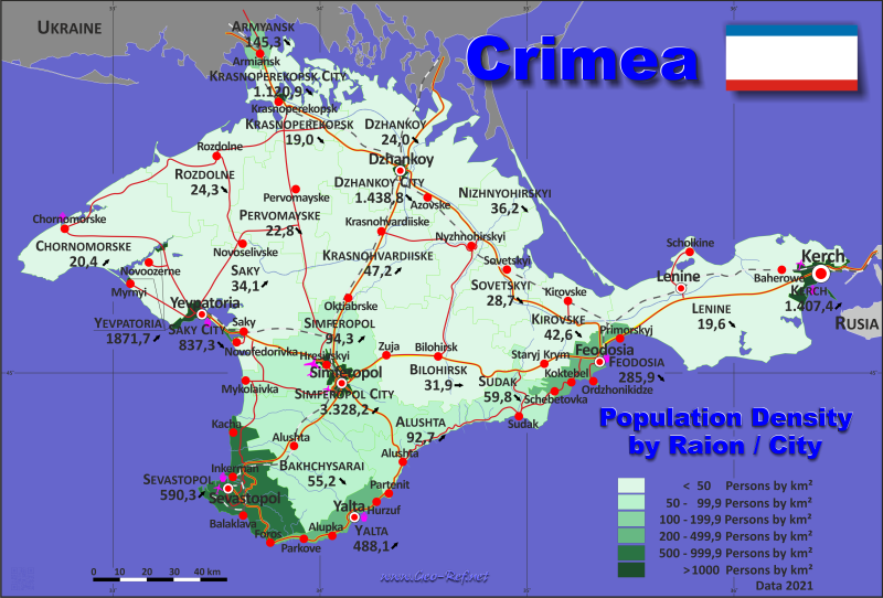
Country map - Administrative structure - Population density of Crimea
Crimea map - Click the map to get map as PDF file.
Other language versions are easy to generate, the descriptions are in own layers
Conditions for thematic maps with your own data and logotype
Delivery as printable file by e-mail or plot by post office
|
|---|
| Layers | |
| Provinces: | yes |
| Streets: | yes |
| Infrastructure: | yes |
| Rivers: | yes |
|
| Size | Till A2 |
| Delivery time | 7 working days | | Price |
| 1 bis 3 | 65 € | | > 3 | On request |
|
 |
All information published herein is free usable quoting the source,
including the maps, if they are not modified
|
|---|
Statistical data - Population density according to the administrative structure
The population data of the table below is an estimation form 2021, last available data.
Click on the column header brings the table in order of the column header.
The default order is the city / raion name.
| City / Raion |
ISO
3166-2 |
Type |
Capital |
Area
(km²) |
Population |
Density
(pers/km²) |
| Total |
|
|
|
26 945 |
2 411 570 |
89,5 |
|---|
| Last update: 01/16/2024 - 22:32:46 |
|---|
| Alushta |
n.d. |
Municipality |
Alushta |
600 |
55 630 |
92,7 |
| Armyansk |
n.d. |
Municipality |
Armyansk |
162 |
23 545 |
145,3 |
| Bakhchysarai |
n.d. |
Raion |
Bakhchysarai |
1 589 |
87 739 |
55,2 |
| Bilohirsk |
n.d. |
Raion |
Bilohirsk |
1 894 |
60 361 |
31,9 |
| Chornomorske |
n.d. |
Raion |
Chornomorske |
1 509 |
30 715 |
20,4 |
| Dzhankoy |
n.d. |
Raion |
Dzhankoy |
2 667 |
64 107 |
24 |
| Dzhankoy City |
n.d. |
Municipality |
Dzhankoy |
26 |
37 410 |
1 438,8 |
| Feodosia |
n.d. |
Municipality |
Feodosia |
350 |
100 056 |
285,9 |
| Kerch |
n.d. |
Municipality |
Kerch |
108 |
151 996 |
1 407,4 |
| Kirovske |
n.d. |
Raion |
Kirovske |
1 208 |
51 423 |
42,6 |
| Krasnohvardiiske |
n.d. |
Raion |
Krasnohvardiiske |
1 766 |
83 287 |
47,2 |
| Krasnoperekopsk |
n.d. |
Raion |
Krasnoperekopsk |
1 231 |
23 402 |
19 |
| Krasnoperekopsk City |
n.d. |
Municipality |
Krasnoperekopsk |
22 |
24 660 |
1 120,9 |
| Nizhnyohirskyi |
n.d. |
Raion |
Nizhnyohirskyi |
1 212 |
43 827 |
36,2 |
| Pervomayske |
n.d. |
Raion |
Pervomaiske |
1 474 |
30 640 |
20,8 |
| Rozdolne |
n.d. |
Raion |
Rozdolne |
1 231 |
29 888 |
24,3 |
| Saki City |
n.d. |
Municipality |
Saki |
29 |
24 282 |
837,3 |
| Saky |
n.d. |
Raion |
Saky |
2 257 |
76 977 |
34,1 |
| Sevastopol |
n.d. |
Raion |
Sevastopol |
864 |
509 992 |
590,3 |
| Simferopol |
n.d. |
Raion |
Simferopol |
1 753 |
165 337 |
94,3 |
| Simferopol City |
n.d. |
Municipality |
Simferopol |
107 |
356 121 |
3 328,2 |
| Sovetskyi |
n.d. |
Raion |
Sovetskyi |
1 080 |
30 987 |
28,7 |
| Sudak |
n.d. |
Municipality |
Sudak |
539 |
32 209 |
59,8 |
| Yalta |
n.d. |
Municipality |
Yalta |
283 |
138 125 |
488,1 |
| Yevpatoria |
n.d. |
Municipality |
Yevpatoria |
65 |
121 660 |
1 871,7 |
Existing thematic maps
|
External links change quickly - If you get a link error - Please inform us!
 |
See also neighboring states
|


