Oriental Republic of Uruguay
| Capital |
Currency | Government system |
|---|
| Montevideo |
Uruguayan Peso (UYU) |
Presidential system |
| Official language | Region |
Population |
|---|
| Spanish |
South America |
Census 2023
3 499 451 |
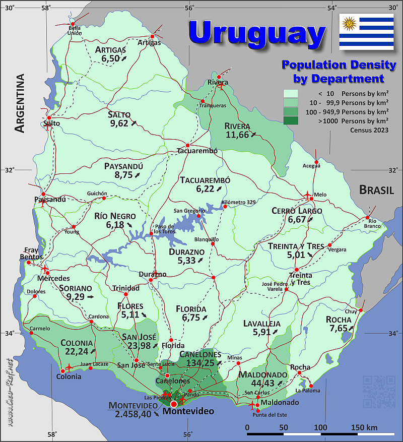
Country map - Administrative structure - Population density of Uruguay
Uruguay map - Click the map to get map as PDF file.
Other language versions are easy to generate, the descriptions are in own layers
Conditions for thematic maps with your own data and logotype
Delivery as printable file by e-mail or plot by post office
|
|---|
| Layers | |
| Provinces: | yes |
| Streets: | yes |
| Infrastructure: | yes |
| Rivers: | yes |
|
| Size | Till A2 |
| Delivery time | 7 working days | | Price |
| 1 bis 3 | 70 € | | > 3 | On request |
|
 |
All information published herein is free usable quoting the source,
including the maps, if they are not modified
|
|---|
Statistical data - Population density according to the administrative structure
The population data of the table below is census data from 2023, last available data.
Click on the column header brings the table in order of the column header.
The default order is the province name.
| Province |
ISO
3166-2 |
Capital |
Area
(km²) |
Population |
Density
(pers/km²) |
| Total |
|
|
175 016 |
3 499 451 |
20,00 |
|---|
| Last update: 12/16/2025 - 21:49:09 |
|---|
| Artigas |
UY-AR |
Artigas |
11 928 |
77 487 |
6,50 |
| Canelones |
UY-CA |
Canelones |
4 536 |
608 956 |
134,25 |
| Cerro Largo |
UY-CL |
Melo |
13 648 |
91 025 |
6,67 |
| Colonia |
UY-CO |
Colonia del Sacramento |
6 106 |
135 797 |
22,24 |
| Durazno |
UY-DU |
Durazno |
11 643 |
62 011 |
5,33 |
| Flores |
UY-FS |
Florida |
5 144 |
26 271 |
5,11 |
| Florida |
UY-FD |
Trinidad |
10 417 |
70 325 |
6,75 |
| Lavalleja |
UY-LA |
Minas |
10 016 |
59 175 |
5,91 |
| Maldonado |
UY-MA |
Maldonado |
4 793 |
212 951 |
44,43 |
| Montevideo |
UY-MO |
Montevideo |
530 |
1 302 954 |
2 458,40 |
| Paysandu |
UY-PA |
Paysandú |
13 922 |
121 843 |
8,75 |
| Rio Negro |
UY-RN |
Fray Bentos |
9 282 |
57 334 |
6,18 |
| Rivera |
UY-RV |
Rocha |
9 370 |
109 300 |
11,66 |
| Rocha |
UY-RO |
Rivera |
10 551 |
80 707 |
7,65 |
| Salto |
UY-SA |
Salto |
14 163 |
136 197 |
9,62 |
| San Jose |
UY-SJ |
San José de Mayo |
4 992 |
119 714 |
23,98 |
| Soriano |
UY-SO |
Mercedes |
9 008 |
83 685 |
9,29 |
| Tacuarembó |
UY-TA |
Tacuarembó |
15 438 |
96 013 |
6,22 |
| Treinta y Tres |
UY-TT |
Treinta y Tres |
9 529 |
47 706 |
5,01 |
Existing thematic maps
|
External links change quickly - If you get a link error - Please inform us!
 |
Membership in international organisations and treaties
Expand list
Political Alliances
Regional Unions
Military alliances/Arms control
Law enforcement
Business Alliances
Fishery
Financial
Free Trade Area, Internal Market
Technical alliances
Environment
Transport
Cientific
Humanitarian Unions
Cultural Unions
|
|
If you have suggestions to include other information or you find missed links, please inform us!
Click here ... |
International Border disputes
Expand list
Land boundaries
Maritime boundaries
See also neighboring states
|
| |


