Republic of Trinidad & Tobago
Country map - Administrative structure - Population density of Trinidad & Tobago
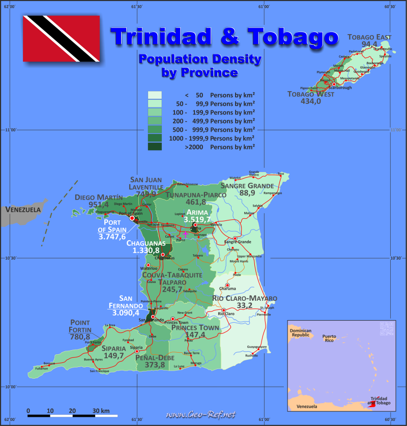
Trinidad & Tobago map - Click the map to get map as PDF file.
Other language versions are easy to generate, the descriptions are in own layers
Conditions for thematic maps with your own data and logotype
Delivery as printable file by e-mail or plot by post office
|
|---|
| Layers | |
| Provinces: | yes |
| Streets: | yes |
| Infrastructure: | yes |
| Rivers: | yes |
|
| Size | Till A2 |
| Delivery time | 7 working days | | Price |
| 1 bis 3 | 65 € | | > 3 | On request |
|
 |
All information published herein is free usable quoting the source,
including the maps, if they are not modified
|
|---|
Statistical data - Population density according to the administrative structure
The population data of the table below is an estimation form 2024, last available data.
Click on the column header brings the table in order of the column header.
The default order is the district name.
| DIstrict |
ISO
3166-2 |
Capital |
Area
(km²) |
Population |
Density
(pers/km²) |
| Total |
|
|
|
5 127,0 |
1 419 700 |
|---|
| Last update: 01/02/2026 - 20:37:34 |
|---|
| Arima |
TT-ARI |
Boroughs |
Arima |
12,0 |
35 900 |
| Chaguanas |
TT-CHA |
Region |
Chaguanas |
59,0 |
89 300 |
| Couva-Tabaquite-Talparo |
TT-CTT |
Region |
Couva |
723,0 |
190 700 |
| Diego Martin |
TT-DMN |
Boroughs |
Diego Martin |
126,0 |
110 000 |
| Peñal-Debe |
TT-PED |
Region |
Penal |
246,0 |
95 600 |
| Point Fortin |
TT-PTF |
Boroughs |
Point Fortin |
25,0 |
21 600 |
| Port of Spain City |
TT-POS |
City |
Port of Spain |
12,0 |
39 600 |
| Princes Town |
TT-PRT |
Region |
Princes Town |
620,0 |
109 500 |
| Rio Claro-Mayaro |
TT-RCM |
Region |
Rio Claro |
814,0 |
38 100 |
| San Fernando City |
TT-SFO |
City |
San Fernando |
19,0 |
52 200 |
| San Juan-Laventille |
TT-SJL |
Boroughs |
San Juan |
239,0 |
168 100 |
| Sangre Grande |
TT-SGE |
Region |
Sangre Grande |
927,0 |
81 000 |
| Siparia |
TT-SIP |
Region |
Siparia |
495,0 |
93 000 |
| Tobago East |
TT-ETO |
Ward |
Charlotteville |
203,0 |
20 367 |
| Tobago West |
TT-WTO |
Ward |
Scarborough |
97,0 |
44 733 |
| Tunapuna-Piarco |
TT-TUP |
Region |
Tunapuna |
510,0 |
230 000 |
Existing thematic maps
|
External links change quickly - If you get a link error - Please inform us!
 |
Membership in international organisations and treaties
Expand list
Political Alliances
Regional Unions
Military alliances/Arms control
Law enforcement
Business Alliances
Fishery
Financial
Free Trade Area, Internal Market
Technical alliances
Transport
Cientific
Humanitarian Unions
Cultural Unions
|
|
If you have suggestions to include other information or you find missed links, please inform us!
Click here ... |
International Border disputes
Expand list
See also neighboring states
|
| |


