Solomon Islands
| Capital |
Currency | Government system |
|---|
| Honiara |
Solomon Islands Dollar (SBD) |
Constitutional monarchy |
| Official language | Region |
Population |
|---|
| English |
Australia & Oceania |
Estimation 2019
720 956,0 |
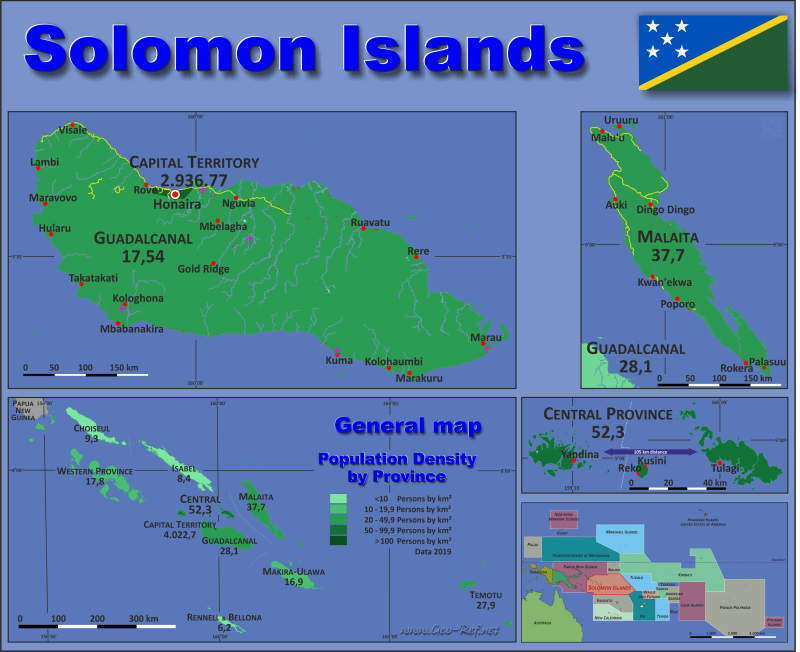
Country map - Administrative structure - Population density of Solomon Islands
Solomon Islands map - Click the map to get map as PDF file.
Other language versions are easy to generate, the descriptions are in own layers
Conditions for thematic maps with your own data and logotype
Delivery as printable file by e-mail or plot by post office
|
|---|
| Layers | |
| Provinces: | yes |
| Streets: | yes |
| Infrastructure: | yes |
| Rivers: | yes |
|
| Size | Till A2 |
| Delivery time | 7 working days | | Price |
| 1 bis 3 | 60 € | | > 3 | On request |
|
 |
All information published herein is free usable quoting the source,
including the maps, if they are not modified
|
|---|
Statistical data - Population density according to the administrative structure
The population data of the table below is an estimation form 2019, last available data.
Click on the column header brings the table in order of the column header.
The default order is the province name.
| Province |
ISO
3166-2 |
Capital |
Area
(km²) |
Population |
Density
(pers/km²) |
| Total |
|
|
28 993,9 |
720 956,0 |
24,9 |
|---|
| Last update: 11/04/202 - 00:44:03 |
|---|
| Capital Territory |
- |
Honiara |
23,6 |
129 569 |
5 490,2 |
| Central |
SB-CN |
Tulagi |
662,2 |
30 318 |
45,8 |
| Choiseul |
SB-CH |
Taro Island |
3 362,4 |
30 775 |
9,2 |
| Guadalcanal |
SB-GU |
Honiara |
5 540,1 |
154 022 |
27,8 |
| Isabel |
SB-IS |
Buala |
4 322,9 |
31 420 |
7,3 |
| Makira-Ulawa |
SB-MK |
Kirakira |
3 347,0 |
51 587 |
15,4 |
| Malaita |
SB-ML |
Auki |
4 337,4 |
172 740 |
39,8 |
| Rennell and Bellona |
SB-RB |
Tigoa |
870,1 |
4 100 |
4,7 |
| Temotu |
SB-TE |
Lata |
916,7 |
22 319 |
24,3 |
| Western |
SB-WE |
Gizo |
5 611,5 |
94 106 |
16,8 |
The province sare subdivided into wards, and their data can be found in the following table.shown in the next table.
| Ward |
HASC |
Province |
Capital
| Area
(km²) |
Population |
Density
(pers/km²) |
| Total |
|
|
|
28 993,9 |
720 956,0 |
24,9 |
|---|
| Last update: 11/04/202 - 00:44:03 |
|---|
| Aba - Asimeuru |
SB ML AA |
Malaita |
Mwaniade |
110,6 |
5 929 |
53,6 |
| Aiaisi |
SB ML AI |
Malaita |
Manawai |
432,6 |
4 190 |
9,7 |
| Aimela |
SB ML AL |
Malaita |
Aimela ? |
79,7 |
8 734 |
109,6 |
| Aola |
SB GU AO |
Guadalcanal |
Aola |
169,2 |
6 377 |
37,7 |
| Areare |
SB ML AR |
Malaita |
Taka Taka |
261,6 |
4 009 |
15,3 |
| Arosi East |
SB MK AE |
Makira-Ulawa |
Raoa |
113,3 |
2 746 |
24,2 |
| Arosi North |
SB MK AN |
Makira-Ulawa |
Heuru |
99,2 |
2 820 |
28,4 |
| Arosi South |
SB MK AS |
Makira-Ulawa |
Oneibia |
166,6 |
3 169 |
19,0 |
| Arosi West |
SB MK AW |
Makira-Ulawa |
Tawaiabu |
81,1 |
2 425 |
29,9 |
| Asimae |
SB ML AS |
Malaita |
Rokera |
163,5 |
4 168 |
25,5 |
| Auki |
SB ML AU |
Malaita |
Auki |
4,5 |
7 020 |
1 560,0 |
| Avuavu |
SB GU AV |
Guadalcanal |
Avuavu |
268,5 |
2 913 |
10,8 |
| Babatana |
SB CH BB |
Choiseul |
Vanggoso |
213,3 |
2 031 |
9,5 |
| Baegu East |
SB ML EB |
Malaita |
n d |
106,5 |
6 784 |
63,7 |
| Baegu - Fataleka West |
SB ML WB |
Malaita |
Ko'ore |
108,4 |
6 220 |
57,4 |
| Bangera |
SB CH BG |
Choiseul |
Mbangara |
141,9 |
1 603 |
11,3 |
| Banika |
SB CN BA |
Central |
Yandia |
48,5 |
2 115 |
43,6 |
| Baolo |
SB IS BA |
Isabel |
Baolo |
520,9 |
1 808 |
3,5 |
| Batava |
SB CH BV |
Choiseul |
Poroporo |
313,1 |
5 677 |
18,1 |
| Bauro Central |
SB MK BC |
Makira-Ulawa |
Kirakira |
172,2 |
5 557 |
32,3 |
| Bauro East |
SB MK BE |
Makira-Ulawa |
Namakohigho |
167,0 |
2 418 |
14,5 |
| Bauro West |
SB MK BW |
Makira-Ulawa |
Rongoidjeni |
553,4 |
5 221 |
9,4 |
| Birao |
SB GU BI |
Guadalcanal |
Savekau |
259,7 |
4 043 |
15,6 |
| Buala |
SB IS BU |
Isabel |
Buala |
19,7 |
3 369 |
171,0 |
| Buma |
SB ML BU |
Malaita |
Buma |
118,7 |
8 122 |
68,4 |
| Central Ranongga |
SB WE CR |
Western |
Pienuna |
40,2 |
2 832 |
70,4 |
| Cruz |
SB CT HC |
Honiara |
Cruz |
0,3 |
394 |
1 313,3 |
| Duff Islands |
SB TE DI |
Temotu |
Tuleki |
14,4 |
493 |
34,2 |
| Duidui |
SB GU DU |
Guadalcanal |
Nduindui |
337,6 |
5 300 |
15,7 |
| East Gela |
SB CN EG |
Central |
Vura |
60,0 |
2 494 |
41,6 |
| East Ghaobata |
SB GU EG |
Guadalcanal |
Mbinu |
73,2 |
6 222 |
85,0 |
| Fauabu |
SB ML FA |
Malaita |
Saia |
192,8 |
9 926 |
51,5 |
| Faumamanu - Kwai |
SB ML FK |
Malaita |
Faumamanu |
95,8 |
3 700 |
38,6 |
| Fenualoa |
SB TE FE |
Temotu |
Tuo |
5,8 |
1 262 |
217,6 |
| Foondo - Gwaiau |
SB ML FG |
Malaita |
Alite'au |
92,2 |
6 588 |
71,5 |
| Fouenda |
SB ML FO |
Malaita |
Hatodeea |
17,7 |
2 381 |
134,5 |
| Gaongau East |
SB RB EG |
Rennell & Bellona |
n d |
5,4 |
225 |
41,7 |
| Gaongau West |
SB RB WG |
Rennell & Bellona |
Ngongona |
259,8 |
336 |
1,3 |
| Gela North East |
SB CN NE |
Central |
Kombe |
50,1 |
2 567 |
51,2 |
| Gela North West |
SB CN NW |
Central |
Vatupura |
74,3 |
2 030 |
27,3 |
| Gela South East |
SB CN SE |
Central |
Vuturua |
58,8 |
1 819 |
30,9 |
| Gela South West |
SB CN SW |
Central |
Mbola |
36,6 |
3 154 |
86,2 |
| Gela West |
SB CN WG |
Central |
Nggela |
73,5 |
2 588 |
35,2 |
| Ghaobata West |
SB GU WG |
Guadalcanal |
Ilu |
84,8 |
7 453 |
87,9 |
| Gizo |
SB WE GI |
Western |
Gizo |
37,6 |
9 455 |
251,5 |
| Graciosa Bay |
SB TE GB |
Temotu |
Nembo Springs |
76,2 |
1 451 |
19,0 |
| Gulalofou |
SB ML GU |
Malaita |
Atofi |
100,6 |
8 609 |
85,6 |
| Haununu |
SB MK HA |
Makira-Ulawa |
Apaoro |
439,7 |
3 237 |
7,4 |
| Hovikoilo |
SB IS HO |
Isabel |
Popoheo |
195,7 |
2 462 |
12,6 |
| Inner Shortlands |
SB WE IS |
Western |
n d |
246,7 |
3 023 |
12,3 |
| Irringgila |
SB WE IR |
Western |
Gevo |
205,9 |
3 300 |
16,0 |
| Japuana |
SB IS JA |
Isabel |
Talise |
254,5 |
2 597 |
10,2 |
| Kaloka |
SB IS KA |
Isabel |
Poro |
23,8 |
1 238 |
52,0 |
| Kanava |
SB RB KA |
Rennell & Bellona |
Kanava |
3,2 |
780 |
243,8 |
| Katupika |
SB CH KA |
Choiseul |
Ruruvai |
466,8 |
2 318 |
5,0 |
| Kerepangara |
SB CH KE |
Choiseul |
Lulemikilo |
148,4 |
1 248 |
8,4 |
| Kia |
SB IS KI |
Isabel |
Kia |
495,1 |
1 909 |
3,9 |
| Kirugela |
SB CH KI |
Choiseul |
Vure |
355,2 |
1 465 |
4,1 |
| Kmaga |
SB IS KM |
Isabel |
Kmaga |
131,1 |
2 218 |
16,9 |
| Kokota |
SB IS KK |
Isabel |
Goveo |
489,6 |
1 671 |
3,4 |
| Kola'a |
SB CT HR |
Honiara |
Kola'a |
4,9 |
20 783 |
4 241,4 |
| Kolokarako |
SB GU KO |
Guadalcanal |
Aroaro |
347,4 |
2 647 |
7,6 |
| Kolombaghea |
SB WE KO |
Western |
Kolombaghea |
307,5 |
3 565 |
11,6 |
| Kolombangara North |
SB WE NK |
Western |
Habere |
289,5 |
2 922 |
10,1 |
| Kolombangara South |
SB WE SK |
Western |
Ringgi |
415,6 |
4 934 |
11,9 |
| Kolomola |
SB IS KO |
Isabel |
Koghe |
105,0 |
1 164 |
11,1 |
| Kolotubi |
SB IS KT |
Isabel |
Ghove |
127,5 |
1 980 |
15,5 |
| Koviloko |
SB IS KV |
Isabel |
n d |
69,0 |
1 144 |
16,6 |
| Kukum |
SB CT HK |
Honiara |
Kukum |
0,3 |
2 541 |
8 470,0 |
| Kusaghe |
SB WE KU |
Western |
Kusaghe |
304,9 |
2 508 |
8,2 |
| Kwaimela - Radefasu |
SB ML KR |
Malaita |
Sita |
136,4 |
11 621 |
85,2 |
| Kwarekwareo |
SB ML KW |
Malaita |
Hauhui |
204,6 |
2 785 |
13,6 |
| Langalanga |
SB ML LA |
Malaita |
Mage |
9,5 |
3 113 |
327,7 |
| Lipe - Temua |
SB TE LT |
Temotu |
Lipe |
4,3 |
747 |
173,7 |
| Longgu |
SB GU LO |
Guadalcanal |
Tavughi |
123,2 |
4 597 |
37,3 |
| Lovukol |
SB CN LO |
Central |
None |
48,1 |
2 576 |
53,6 |
| Luaniua |
SB ML LU |
Malaita |
Luaniua |
8,1 |
1 965 |
242,6 |
| Lughu |
SB RB LU |
Rennell & Bellona |
Lughu |
204,3 |
308 |
1,5 |
| Luva Station |
SB TE LS |
Temotu |
Lata |
6,8 |
1 953 |
287,2 |
| Malango |
SB GU MA |
Guadalcanal |
Tenaru |
562,9 |
24 649 |
43,8 |
| Malu'u |
SB ML ML |
Malaita |
Malu'u |
20,7 |
5 672 |
274,0 |
| Mandalua - Folotana |
SB ML MF |
Malaita |
Okoai |
85,1 |
3 940 |
46,3 |
| Manuopo |
SB TE MA |
Temotu |
Nuali |
9,0 |
1 112 |
123,6 |
| Mareho |
SB ML MR |
Malaita |
Harumou |
210,6 |
2 820 |
13,4 |
| Matakwalao |
SB ML MT |
Malaita |
Manafaeni |
34,5 |
3 563 |
103,3 |
| Matangi |
SB RB MA |
Rennell & Bellona |
Peka |
90,9 |
429 |
4,7 |
| Mataniko |
SB CT HT |
Honiara |
Mataniko |
0,8 |
5 722 |
7 152,5 |
| Mbilua |
SB WE MB |
Western |
Njorovete |
228,4 |
4 502 |
19,7 |
| Mbuini Tusu |
SB CT HB |
Western |
Mbuini Tusu |
656,9 |
3 799 |
5,8 |
| Mbumburu |
SB WE MT |
Honiara |
Mbumburu |
1,2 |
5 806 |
4 838,3 |
| Moli |
SB GU MO |
Guadalcanal |
Sukiki |
140,3 |
4 507 |
32,1 |
| Mugi Henua |
SB RB MH |
Rennell & Bellona |
Kangua |
4,9 |
214 |
43,7 |
| Munda |
SB WE MU |
Western |
Munda |
310,7 |
3 797 |
12,2 |
| Nafinua |
SB ML NA |
Malaita |
Kwai |
135,3 |
4 593 |
33,9 |
| Naha |
SB CT HN |
Honiara |
Naha |
n d |
464 |
n d |
| Nanggu - Lord Howe |
SB TE NH |
Temotu |
Masoko |
259,7 |
2 144 |
8,3 |
| Ndovele |
SB WE ND |
Western |
Ndovele |
161,9 |
2 057 |
12,7 |
| Nea - Noole |
SB TE NN |
Temotu |
Toa |
63,6 |
1 837 |
28,9 |
| Nenumpo |
SB TE NP |
Temotu |
Lomiom |
6,7 |
1 079 |
161,0 |
| Neo |
SB TE NE |
Temotu |
Neo |
15,3 |
1 701 |
111,2 |
| Nevenema |
SB TE NV |
Temotu |
Baenga |
25,8 |
1 081 |
41,9 |
| Nggatokae |
SB WE NT |
Western |
Nggatokae |
195,8 |
3 434 |
17,5 |
| Nggosi |
SB CT HG |
Honiara |
Nggosi |
3,8 |
26 009 |
6 844,5 |
| Nipua - Nopoli |
SB TE NI |
Temotu |
Namania |
2,7 |
912 |
337,8 |
| Nono |
SB WE NN |
Western |
Nono |
469,7 |
4 065 |
8,7 |
| Noro |
SB WE NO |
Western |
Noro |
13,2 |
7 204 |
545,8 |
| Nusa Roviana |
SB WE NU |
Western |
Nusa Roviana |
15,6 |
2 284 |
146,4 |
| Outer Shortlands |
SB WE OS |
Western |
Korovou |
185,8 |
1 444 |
7,8 |
| Panatina |
SB CT HP |
Honiara |
Panatina |
7,0 |
32 712 |
4 673,1 |
| Paripao |
SB GU PA |
Guadalcanal |
Inusi |
169,8 |
3 842 |
22,6 |
| Pavuvu |
SB CN PA |
Central |
Losioleni |
130,6 |
2 051 |
15,7 |
| Pelau |
SB ML PE |
Malaita |
Pelau |
0,5 |
1 041 |
2 082,0 |
| Polo |
SB CH PO |
Choiseul |
Mbumbukuana |
151,8 |
2 003 |
13,2 |
| Polynesian Outer Islands |
SB TE OI |
Temotu |
None |
1,2 |
283 |
235,8 |
| Ranongga North |
SB WE NG |
Western |
Sabala |
30,9 |
552 |
17,9 |
| Ranongga South |
SB WE SG |
Western |
Lale |
79,6 |
3 358 |
42,2 |
| Rarosu'u |
SB ML RA |
Malaita |
Apuara |
171,1 |
6 049 |
35,4 |
| Rawo |
SB MK RA |
Makira-Ulawa |
Rawo |
295,8 |
934 |
3,2 |
| Rendova North |
SB WE NR |
Western |
Eghelo |
178,9 |
1 907 |
10,7 |
| Rendova South |
SB WE SR |
Western |
Ughele |
359,6 |
2 643 |
7,3 |
| Rove - Lengakiki |
SB CT HL |
Honiara |
Rove - Lengakiki |
1,0 |
4 244 |
4 244,0 |
| Roviana Lagoon |
SB WE RL |
Western |
Mbiula |
478,7 |
5 206 |
10,9 |
| Sa'aiho |
SB RB SA |
Rennell & Bellona |
Matahenua |
131,5 |
219 |
1,7 |
| Saghalu |
SB GU SG |
Guadalcanal |
Aruliho |
229,9 |
11 030 |
48,0 |
| Samasodu |
SB IS SA |
Isabel |
Samasodu |
1 083,0 |
2 485 |
2,3 |
| Sandfly - Buenavista |
SB CN SB |
Central |
Boroni |
48,7 |
3 729 |
76,6 |
| Santa Ana |
SB MK SA |
Makira-Ulawa |
Ghupuna |
15,5 |
1 939 |
125,1 |
| Santa Catalina |
SB MK SC |
Makira-Ulawa |
Ragapu |
5,3 |
1 015 |
191,5 |
| Santa Cruz North East |
SB TE CZ |
Temotu |
Matela |
135,3 |
2 178 |
16,1 |
| Savo North |
SB CN NS |
Central |
Raja |
14,2 |
1 564 |
110,1 |
| Savo South |
SB CN SS |
Central |
Reko |
16,3 |
2 150 |
131,9 |
| Savulei |
SB GU SV |
Guadalcanal |
Lambi |
165,4 |
4 331 |
26,2 |
| Senga |
SB CH SE |
Choiseul |
Njenjepele |
308,1 |
2 117 |
6,9 |
| Siesie |
SB ML SS |
Malaita |
Maeana |
281,3 |
4 508 |
16,0 |
| Sigana |
SB IS SI |
Isabel |
Ole |
99,8 |
2 691 |
27,0 |
| Sikaiana |
SB ML SN |
Malaita |
Sikaiana |
1,3 |
359 |
276,2 |
| Simbo |
SB WE SI |
Western |
Simbo |
13,2 |
1 782 |
135,0 |
| Star Harbour North |
SB MK SN |
Makira-Ulawa |
Tawarogha |
204,0 |
4 106 |
20,1 |
| Star Harbour South |
SB MK SS |
Makira-Ulawa |
Mania |
269,7 |
1 561 |
5,8 |
| Sububenu - Burianiasi |
SB ML SB |
Malaita |
Abe |
254,0 |
4 450 |
17,5 |
| Sulufou - Kwarande |
SB ML SK |
Malaita |
n d |
n d |
2 747 |
n d |
| Susubona |
SB IS SU |
Isabel |
Biluro |
449,6 |
2 342 |
5,2 |
| Susuka |
SB CH SU |
Choiseul |
Soranamoka |
264,2 |
1 939 |
7,3 |
| Tai |
SB ML TA |
Malaita |
Koruha |
299,4 |
5 188 |
17,3 |
| Takwa |
SB ML TK |
Malaita |
Takwa |
147,4 |
12 445 |
84,4 |
| Talise |
SB GU TL |
Guadalcanal |
Kologhasi |
165,2 |
2 628 |
15,9 |
| Tandai |
SB GU TD |
Guadalcanal |
Mamara |
473,3 |
33 056 |
69,8 |
| Tangarare |
SB GU TR |
Guadalcanal |
Tangarare |
406,4 |
3 852 |
9,5 |
| Tasimboko East |
SB GU ET |
Guadalcanal |
Ruavatu |
181,6 |
10 088 |
55,6 |
| Tatamba |
SB IS TA |
Isabel |
Sidu |
146,7 |
1 649 |
11,2 |
| Tavula |
SB CH TA |
Choiseul |
Mbanimbani |
144,3 |
2 751 |
19,1 |
| Te Tau Gangoto |
SB CH TE |
Rennell & Bellona |
Tigoa |
3,9 |
333 |
85,4 |
| Tenggano East |
SB RB ET |
Rennell & Bellona |
n d |
73,6 |
881 |
12,0 |
| Tenggano West |
SB RB WT |
Rennell & Bellona |
n d |
92,6 |
375 |
4,0 |
| Tepazaka |
SB RB TT |
Choiseul |
Sagigai |
212,8 |
2 274 |
10,7 |
| Tetekanji |
SB GU TK |
Guadalcanal |
Vola |
345,5 |
1 602 |
4,6 |
| Tikopia |
SB TE TI |
Temotu |
Tikopia |
6,6 |
1 060 |
160,6 |
| Tirotongana |
SB IS TI |
Isabel |
Tocasalo |
111,9 |
693 |
6,2 |
| Tulagi |
SB CN TU |
Central |
Tulagi |
2,5 |
1 481 |
592,4 |
| Ugi and Pio |
SB MK UP |
Makira-Ulawa |
Kerepei |
47,7 |
1 598 |
33,5 |
| Ulawa North |
SB MK NU |
Makira-Ulawa |
Moli |
25,6 |
1 428 |
55,8 |
| Ulawa South |
SB MK SU |
Makira-Ulawa |
Su'utolaito |
26,5 |
1 499 |
56,6 |
| Ulawa West |
SB MK WU |
Makira-Ulawa |
Hadja |
13,6 |
1 064 |
78,2 |
| Utupua |
SB TE UT |
Temotu |
Avita |
76,3 |
1 356 |
17,8 |
| Valasi |
SB GU VS |
Guadalcanal |
Dalikon |
255,0 |
2 070 |
8,1 |
| Vangunu North |
SB WE NV |
Western |
Batuna |
100,8 |
3 211 |
31,9 |
| Vanikoro |
SB TE VA |
Temotu |
Vanikoro |
207,0 |
1 670 |
8,1 |
| Vasipuki |
SB CH VA |
Choiseul |
Kakaza |
338,8 |
1 952 |
5,8 |
| Vatukulau |
SB GU VT |
Guadalcanal |
Inaato |
131,0 |
2 534 |
19,3 |
| Vavaea |
SB CT HV |
Honiara |
Vavaea |
2,0 |
10 813 |
5 406,5 |
| Viviru |
SB CH VI |
Choiseul |
Tunoe |
219,2 |
1 615 |
7,4 |
| Vonavona |
SB WE VV |
Western |
Vona Vona |
187,3 |
6 398 |
34,2 |
| Vonunu |
SB WE VN |
Western |
Vonunu |
96,6 |
3 924 |
40,6 |
| Vuhokesa |
SB CT HS |
Honiara |
Vuhokesa |
0,3 |
1 328 |
4 426,7 |
| Vulolo |
SB GU VO |
Guadalcanal |
Koleasi |
383,2 |
6 265 |
16,3 |
| Vura |
SB CT HU |
Honiara |
Vura |
2,0 |
18 753 |
9 376,5 |
| Wagina |
SB CH WA |
Choiseul |
Nikomaroro |
84,5 |
1 782 |
21,1 |
| Wainoni East |
SB MK WE |
Makira-Ulawa |
Maniate |
138,0 |
3 254 |
23,6 |
| Wainoni West |
SB MK WW |
Makira-Ulawa |
Wango |
150,3 |
3 242 |
21,6 |
| Wanderer Bay |
SB GU WB |
Guadalcanal |
Marasa |
267,0 |
4 016 |
15,0 |
| Waneagu - Taelanasina |
SB ML WT |
Malaita |
Malo'u |
296,4 |
3 682 |
12,4 |
| Weagu Silana Sina |
SB ML WS |
Malaita |
Bina |
156,0 |
5 819 |
37,3 |
| Weather Coast |
SB MK WC |
Makira-Ulawa |
Apurahe |
362,5 |
2 354 |
6,5 |
Existing thematic maps
|
External links change quickly - If you get a link error - Please inform us!
 |
Membership in international organisations and treaties
Expand list
Political Alliances
Regional Unions
Military alliances/Arms control
Law enforcement
Business Alliances
Fishery
Financial
Free Trade Area, Internal Market
Technical alliances
Environment
Transport
Cientific
Humanitarian Unions
Cultural Unions
|
|
If you have suggestions to include other information or you find missed links, please inform us!
Click here ... |
International Border disputes
Expand list
See also neighboring states
|
| |


