Portuguese Republic
| Capital |
Currency | Government system |
|---|
| Lisbon |
Euro (EUR) |
Presidential system |
| Official language | Region |
Population |
|---|
| Portuguese |
Europe |
Estimation 2025
10 749 635 |
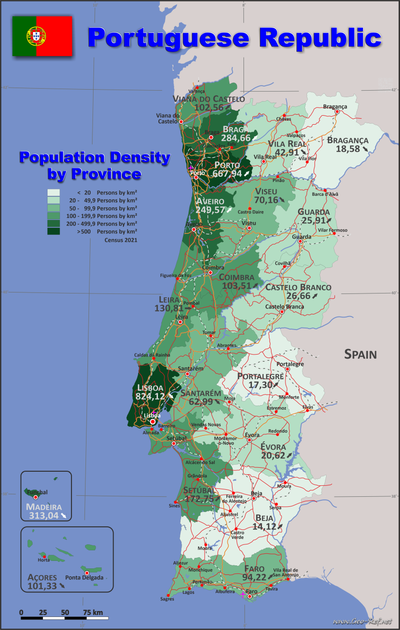
Country map - Administrative structure - Population density of Portugal
Portugal map - Click the map to get map as PDF file.
Other language versions are easy to generate, the descriptions are in own layers
Conditions for thematic maps with your own data and logotype
Delivery as printable file by e-mail or plot by post office
|
|---|
| Layers | |
| Provinces: | yes |
| Streets: | yes |
| Infrastructure: | yes |
| Rivers: | yes |
|
| Size | Till A2 |
| Delivery time | 7 working days | | Price |
| 1 bis 3 | 70 € | | > 3 | On request |
|
 |
All information published herein is free usable quoting the source,
including the maps, if they are not modified
|
|---|
Statistical data - Population density according to the administrative structure
The population data of the table below is an estimation form 2025, based on the census 2021.
Click on the column header brings the table in order of the column header.
The default order is the district / region name.
| District / Region |
ISO
3166-2 |
Tipo |
Capital |
Area
(km²) |
Population |
Density
(pers/km²) |
| Total |
|
|
|
92 636 |
10 749 635 |
116,04 |
|---|
| Last update: 10/24/2025 - 13:50:45 |
|---|
| Aveiro |
PT-01 |
District |
Aveiro |
2 808 |
734 762 |
261,67 |
| Azores |
PT-20 |
Autonomous region |
Ponta Delgada |
2 322 |
241 718 |
104,10 |
| Beja |
PT-02 |
District |
Beja |
10 225 |
149 546 |
14,63 |
| Braga |
PT-03 |
District |
Braga |
2 973 |
867 537 |
291,81 |
| Bragança |
PT-04 |
District |
Bragança |
6 608 |
122 360 |
18,52 |
| Castelo Branco |
PT-05 |
District |
Castelo Branco |
6 675 |
180 889 |
27,10 |
| Coimbra |
PT-06 |
District |
Coimbra |
3 947 |
423 432 |
107,28 |
| Évora |
PT-07 |
District |
Évora |
7 393 |
153 430 |
20,75 |
| Faro |
PT-08 |
District |
Faro |
4 960 |
492 747 |
99,34 |
| Guarda |
PT-09 |
District |
Guarda |
5 518 |
142 210 |
25,77 |
| Leira |
PT-10 |
District |
Leiria |
3 506 |
486 583 |
138,79 |
| Lisboa |
PT-11 |
District |
Lisboa |
2 761 |
2 390 715 |
865,89 |
| Madeira |
PT-30 |
Autonomous region |
Funchal |
801 |
259 440 |
323,90 |
| Portalegre |
PT-12 |
District |
Portalegre |
6 065 |
103 566 |
17,08 |
| Porto |
PT-13 |
District |
Porto |
2 673 |
1 860 255 |
695,94 |
| Santarém |
PT-14 |
District |
Santarém |
6 747 |
446 393 |
66,16 |
| Setúbal |
PT-15 |
District |
Setúbal |
5 064 |
916 859 |
181,05 |
| Viana do Castelo |
PT-16 |
District |
Viana do Castelo |
2 255 |
234 645 |
104,06 |
| Vila Real |
PT-17 |
District |
Vila Real |
4 328 |
184 707 |
42,68 |
| Viseu |
PT-18 |
District |
Viseu |
5 007 |
357 841 |
71,47 |
Existing thematic maps
|
External links change quickly - If you get a link error - Please inform us!
 |
Membership in international organisations and treaties
Expand list
Political Alliances
Regional Unions
Military alliances/Arms control
Law enforcement
Business Alliances
Fishery
Financial
Free Trade Area, Internal Market
Technical alliances
Transport
Cientific
Humanitarian Unions
Cultural Unions
|
|
If you have suggestions to include other information or you find missed links, please inform us!
Click here ... |
See also neighboring states
|


