Republic of Panama
| Capital |
Currency | Government system |
|---|
| Panama-City |
Balboa (PAB) |
Presidential system |
| Official language | Region |
Population |
|---|
| Spanish |
Central America & Caribbean |
Census 2023
4 064 780 |
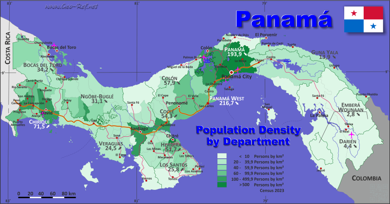
Country map - Administrative structure - Population density of Panama
Panama map - Click the map to get map as PDF file.
Other language versions are easy to generate, the descriptions are in own layers
Conditions for thematic maps with your own data and logotype
Delivery as printable file by e-mail or plot by post office
|
|---|
| Layers | |
| Provinces: | yes |
| Streets: | yes |
| Infrastructure: | yes |
| Rivers: | yes |
|
| Size | Till A2 |
| Delivery time | 7 working days | | Price |
| 1 bis 3 | 60 € | | > 3 | On request |
|
 |
All information published herein is free usable quoting the source,
including the maps, if they are not modified
|
|---|
Statistical data - Population density according to the administrative structure
The population data of the table below is census data from 2023, last available data.
Click on the column header brings the table in order of the column header.
The default order is the province name.
| Province |
ISO
3166-2 |
Capital |
Area
(km²) |
Population |
Density
(pers/km²) |
| Total |
|
|
75 319 |
4 064 780 |
54,0 |
|---|
| Last update: 17.01.2023 - 22:59:23 |
|---|
| Bocas del Toro |
PA-1 |
Bocas del Toro |
4 654 |
159 228 |
34,2 |
| Chiriqui |
PA-4 |
David |
6 584 |
471 071 |
71,5 |
| Cocle |
PA-2 |
Penonomé |
4 941 |
268 264 |
54,3 |
| Colon |
PA-3 |
Colón |
4 867 |
281 956 |
57,9 |
| Darien |
PA-5 |
La Palma |
12 195 |
54 235 |
4,4 |
| Emberá |
PA-EM |
Unión Chocó |
4 366 |
12 358 |
2,8 |
| Guna Yala |
PA-KY |
El Porvenir |
2 308 |
32 016 |
13,9 |
| Herrera |
PA-6 |
Chitré |
2 363 |
122 071 |
51,7 |
| Los Santos |
PA-7 |
Las Tablas |
3 812 |
98 466 |
25,8 |
| Ngöbe-Buglé |
PA-NB |
Llano Tugrí |
6 829 |
212 084 |
31,1 |
| Panama |
PA-8 |
Panamá |
8 785 |
1 439 575 |
163,9 |
| Panama - West |
PA-10 |
La Chorrera |
3 016 |
653 665 |
216,7 |
| Veraguas |
PA-9 |
Santiago |
10 599 |
259 791 |
24,5 |
The provinces are divided in districts, illustrated in the next table. Instead of the not existing ISO 3166-2 district classification is used the HASC codification.
| District |
HASC |
Province |
Capital
| Area
(km²) |
Population |
Density
(pers/km²) |
| Total |
|
|
|
75 319 |
4 064 780 |
54,0 |
|---|
| Last update: 17.01.2023 - 22:59:23 |
|---|
| Aguadulce |
CC-AG |
Coclé |
Aguadulce |
470 |
49 005 |
104,3 |
| Alanje |
CH-AL |
Chiriquí |
Alanje |
455 |
18 877 |
41,5 |
| Almirante |
n.d. |
Bocas del Toro |
Puerto Almirante |
1 937 |
28 368 |
14,6 |
| Antón |
CC-AN |
Coclé |
Antón |
743 |
59 194 |
79,7 |
| Arraiján |
PO-AR |
Panama - West |
Arraiján |
433 |
299 079 |
690,7 |
| Atalaya |
VR-AT |
Veraguas |
Atalaya |
156 |
17 507 |
112,2 |
| Balboa |
PM-BB |
Panamá |
San Miguel |
332 |
1 989 |
6,0 |
| Barú |
CH-BR |
Chiriquí |
Puerto Armuelles |
600 |
56 307 |
93,8 |
| Besiko |
NB-BK |
Ngäbe Buglé |
Soloy |
753 |
31 422 |
41,7 |
| Bocas del Toro |
BC-BT |
Bocas del Toro |
Bocas City |
285 |
17 274 |
60,6 |
| Boquerón |
CH-BN |
Chiriquí |
Boquerón |
292 |
21 001 |
71,9 |
| Boquete |
CH-BQ |
Chiriquí |
Bajo Boquete |
490 |
23 562 |
48,1 |
| Bugaba |
CH-BG |
Chiriquí |
La Concepción |
517 |
68 870 |
133,2 |
| Calobre |
VR-CB |
Veraguas |
Calobre |
806 |
11 666 |
14,5 |
| Cañazas |
VR-CZ |
Veraguas |
Cañazas |
782 |
16 933 |
21,7 |
| Capira |
PO-CA |
Panama - West |
Capira |
974 |
45 629 |
46,8 |
| Cémaco |
EM-CE |
Emberá |
Unión Chocó |
3 059 |
9 547 |
3,1 |
| Chagres |
CL-CR |
Colón |
Nuevo Chagres |
447 |
10 968 |
24,5 |
| Chame |
PO-CM |
Panama - West |
Chame |
375 |
28 535 |
76,1 |
| Changuinola |
BC-CH |
Bocas del Toro |
Changuinola |
2 222 |
101 091 |
45,5 |
| Chepigana |
DA-CP |
Darién |
La Palma |
4 764 |
12 983 |
2,7 |
| Chepo |
PM-CO |
Panamá |
Chepo |
5 307 |
65 588 |
12,4 |
| Chimán |
PM-CN |
Panamá |
Chimán |
1 002 |
3 142 |
3,1 |
| Chiriquí Grande |
BC-CG |
Bocas del Toro |
Chiriquí Grande |
210 |
12 495 |
59,5 |
| Chitré |
HE-CT |
Herrera |
Chitré |
88 |
60 957 |
692,7 |
| Colón |
CL-CL |
Colón |
Colón City |
1 455 |
240 722 |
165,4 |
| David |
CH-DA |
Chiriquí |
David |
892 |
156 498 |
175,4 |
| Dolega |
CH-DL |
Chiriquí |
Dolega |
251 |
37 678 |
150,1 |
| Donoso |
CL-DN |
Colón |
Miguel de la Borda |
1 628 |
12 274 |
7,5 |
| Gualaca |
CH-GL |
Chiriquí |
Gualaca |
627 |
9 831 |
15,7 |
| Guararé |
LS-GR |
Los Santos |
Guararé |
213 |
12 107 |
56,8 |
| Guna Yala |
SB-KY |
Guna Yala |
El Porvenir |
2 308 |
32 016 |
13,9 |
| Jirondai |
n.d. |
Ngäbe Buglé |
Samboa |
1 379 |
25 804 |
18,7 |
| Kankintú |
NB-KK |
Ngäbe Buglé |
Bisira |
1 044 |
19 751 |
18,9 |
| Kusapín |
NB-KS |
Ngäbe Buglé |
Kusapín |
843 |
17 047 |
20,2 |
| La Chorrera |
PO-LC |
Panama - West |
La Chorrera |
897 |
258 221 |
287,9 |
| La Mesa |
VR-LM |
Veraguas |
La Mesa |
510 |
12 238 |
24,0 |
| La Pintada |
CC-LP |
Coclé |
La Pintada |
1 031 |
29 698 |
28,8 |
| Las Minas |
HE-LN |
Herrera |
Las Minas |
469 |
6 642 |
14,2 |
| Las Palmas |
VR-LA |
Veraguas |
Las Palmas |
1 015 |
18 071 |
17,8 |
| Las Tablas |
LS-LT |
Los Santos |
Las Tablas |
717 |
30 440 |
42,5 |
| Los Pozos |
HE-LZ |
Herrera |
Los Pozos |
385 |
6 928 |
18,0 |
| Los Santos |
LS-LS |
Los Santos |
La Villa de los Santos |
432 |
30 028 |
69,5 |
| Macaracas |
LS-MC |
Los Santos |
Macaracas |
505 |
8 965 |
17,8 |
| Mariato |
VR-MA |
Veraguas |
Mariato |
1 392 |
5 791 |
4,2 |
| Mironó |
NB-MR |
Ngäbe Buglé |
Hato Pilón |
340 |
21 800 |
64,1 |
| Montijo |
VR-MJ |
Veraguas |
Montijo |
774 |
6 784 |
8,8 |
| Müna |
NB-MU |
Ngäbe Buglé |
Chichica |
800 |
47 200 |
59,0 |
| Natá |
CC-NT |
Coclé |
Natá |
613 |
19 741 |
32,2 |
| Nole Duima |
NB-ND |
Ngäbe Buglé |
Cerro Iglesias |
185 |
20 709 |
111,9 |
| Ñürüm |
NB-NR |
Ngäbe Buglé |
Buenos Aires |
582 |
17 637 |
30,3 |
| Ocú |
HE-OC |
Herrera |
Ocú |
619 |
16 116 |
26,0 |
| Olá |
CC-OL |
Coclé |
Olá |
377 |
6 300 |
16,7 |
| Omar Torrijos Herrera |
n.d. |
Colón |
Coclesito |
198 |
3 561 |
18,0 |
| Panamá |
PM-PA |
Panamá |
Panamá City |
2 082 |
1 086 990 |
522,1 |
| Parita |
HE-PR |
Herrera |
Parita |
354 |
9 695 |
27,4 |
| Pedasí |
LS-PD |
Los Santos |
Pedasí |
377 |
4 942 |
13,1 |
| Penonomé |
CC-PN |
Coclé |
Penonomé |
1 707 |
104 326 |
61,1 |
| Pesé |
HE-PS |
Herrera |
Pesé |
289 |
13 009 |
45,0 |
| Pinogana |
DA-PG |
Darién |
El Real de Santa María |
4 899 |
21 523 |
4,4 |
| Pocrí |
LS-PC |
Los Santos |
Pocrí |
276 |
3 025 |
11,0 |
| Portobelo |
CL-PB |
Colón |
Portobelo |
399 |
10 320 |
25,9 |
| Remedios |
CH-RM |
Chiriquí |
Remedios |
172 |
4 388 |
25,5 |
| Renacimiento |
CH-RN |
Chiriquí |
Río Sereno |
528 |
22 429 |
42,5 |
| Río de Jesús |
VR-RJ |
Veraguas |
Río de Jesús |
317 |
4 822 |
15,2 |
| Sambú |
EM-SB |
Emberá |
Puerto Indio |
1 307 |
2 811 |
2,2 |
| San Carlos |
PO-SC |
Panama - West |
San Carlos |
337 |
22 201 |
65,9 |
| San Félix |
CH-SX |
Chiriquí |
Las Lajas |
226 |
6 881 |
30,4 |
| San Francisco |
VR-SF |
Veraguas |
San Francisco |
434 |
10 107 |
23,3 |
| San Lorenzo |
CH-SL |
Chiriquí |
Horconcitos |
689 |
8 031 |
11,7 |
| San Miguelito |
PM-SM |
Panamá |
Panamá City |
50 |
280 777 |
5 615,5 |
| Santa Catalina |
n.d. |
Ngäbe Buglé |
Santa Catalina |
903 |
10 714 |
11,9 |
| Santa Fé |
VR-SE |
Veraguas |
Santa Fe |
1 921 |
18 023 |
9,4 |
| Santa Fe |
n.d. |
Darién |
Santa Fe |
2 532 |
19 729 |
7,8 |
| Santa Isabel |
CL-SI |
Colón |
Palenque |
740 |
4 111 |
5,6 |
| Santa María |
HE-ST |
Herrera |
Santa María |
159 |
8 724 |
54,9 |
| Santiago |
VR-SG |
Veraguas |
Santiago de Veraguas |
970 |
109 605 |
113,0 |
| Soná |
VR-SO |
Veraguas |
Soná |
1 522 |
28 244 |
18,6 |
| Taboga |
PM-TB |
Panamá |
Taboga |
12 |
1 089 |
90,8 |
| Tierras Altas |
n.d. |
Chiriquí |
Volcán |
360 |
23 525 |
65,3 |
| Tolé |
CH-TL |
Chiriquí |
Tolé |
485 |
13 193 |
27,2 |
| Tonosí |
LS-TN |
Los Santos |
Tonosí |
1 292 |
8 959 |
6,9 |
Existing thematic maps
|
External links change quickly - If you get a link error - Please inform us!
 |
Membership in international organisations and treaties
Expand list
Political Alliances
Regional Unions
Military alliances/Arms control
Law enforcement
Business Alliances
Fishery
Financial
Free Trade Area, Internal Market
Technical alliances
Environment
Transport
Cientific
Humanitarian Unions
Cultural Unions
|
|
If you have suggestions to include other information or you find missed links, please inform us!
Click here ... |
International Border disputes
Expand list
Land boundaries
Maritime boundaries
See also neighboring states
|
| |


