Republic of Ireland
| Capital |
Currency | Government system |
|---|
| Dublin |
Euro (EUR) |
Parliamentary democracy |
| Official language | Region |
Population |
|---|
Irish
English |
Europe |
Census 2022
5 123 536 |
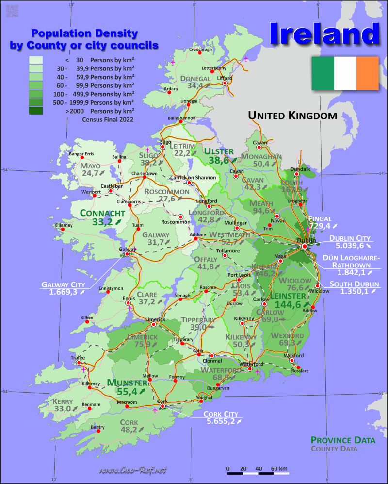
Country map - Administrative structure - Population density of Ireland
Ireland map - Click the map to get map as PDF file.
Other language versions are easy to generate, the descriptions are in own layers
Conditions for thematic maps with your own data and logotype
Delivery as printable file by e-mail or plot by post office
|
|---|
| Layers | |
| Provinces: | yes |
| Streets: | yes |
| Infrastructure: | yes |
| Rivers: | yes |
|
| Size | Till A2 |
| Delivery time | 7 working days | | Price |
| 1 bis 3 | 75 € | | > 3 | On request |
|
 |
All information published herein is free usable quoting the source,
including the maps, if they are not modified
|
|---|
Statistical data - Population density according to the administrative structure
The population data of the table below is census data from 2022, last available data.
Click on the column header brings the table in order of the column header.
The default order is the county and city councils name.
|
Province |
ISO
3166-2 |
Capital |
Area
(km²) |
Population |
Density
(pers/km²) |
| Total |
|
|
70 182,2 |
5 123 536 |
73,0 |
|---|
| Last update: 12.06.2025 - 08:44:38 |
|---|
| Connacht |
IE-C |
Galway |
17 713,2 |
588 583 |
33,2 |
| Leinster |
IE-L |
Dublin |
19 774,2 |
2 858 501 |
144,6 |
| Munster |
IE-M |
Cork |
24 607,5 |
1 364 098 |
55,4 |
| Ulster (part of) |
IE-U |
Lifford |
8 087,3 |
312 354 |
38,6 |
The cunciles are into countries, the data of which are shown in the table below
| County and city councils |
ISO
3166-2 |
Province |
Capital
| Area
(km²) |
Population |
Density
(pers/km²) |
| Total |
|
|
|
70 182,2 |
5 123 536 |
73,0 |
|---|
| Last update: 12.06.2025 - 08:44:38 |
|---|
| Carlow |
IE-CW |
Leinster |
Carlow |
897,9 |
61 931 |
69,0 |
| Cavan |
IE-CN |
Ulster |
Cavan |
1 931,9 |
81 201 |
42,0 |
| Clare |
IE-CE |
Munster |
Ennis |
3 442,3 |
127 419 |
37,0 |
| Cork |
IE-CO |
Munster |
Cork |
7 468,0 |
358 898 |
48,1 |
| Cork City |
|
Munster |
Cork |
39,6 |
222 333 |
5 613,1 |
| Donegal |
IE-DL |
Ulster |
Lifford |
4 859,5 |
166 321 |
34,2 |
| Dublin City |
IE-D |
Leinster |
Dublin |
117,6 |
588 233 |
5 001,6 |
| Dún Laoghaire-Rathdown |
|
Leinster |
Dún Laoghaire |
127,0 |
233 457 |
1 839,0 |
| Fingal |
|
Leinster |
Swords |
453,1 |
329 218 |
726,6 |
| Galway |
IE-G |
Connacht |
Galway |
6 100,0 |
192 995 |
31,6 |
| Galway City |
|
Connacht |
Galway |
50,6 |
83 456 |
1 650,3 |
| Kerry |
IE-KY |
Munster |
Tralee |
4 734,7 |
155 258 |
32,8 |
| Kildare |
IE-KE |
Leinster |
Naas |
1 694,2 |
246 977 |
145,8 |
| Kilkenny |
IE-KK |
Leinster |
Kilkenny |
2 071,7 |
103 685 |
50,0 |
| Laois |
IE-LS |
Leinster |
Portlaoise |
1 719,5 |
91 657 |
53,3 |
| Leitrim |
IE-LM |
Connacht |
Carrick-on-Shannon |
1 588,9 |
35 087 |
22,1 |
| Limerick City and County |
IE-LK |
Munster |
Limerick |
2 760,0 |
205 444 |
74,4 |
| Longford |
IE-LD |
Leinster |
Longford |
1 091,3 |
46 634 |
42,7 |
| Louth |
IE-LH |
Leinster |
Dundalk |
832,0 |
139 100 |
167,2 |
| Mayo |
IE-MO |
Connacht |
Castlebar |
5 588,3 |
137 231 |
24,6 |
| Meath |
IE-MH |
Leinster |
Navan |
2 334,5 |
220 296 |
94,4 |
| Monaghan |
IE-MN |
Ulster |
Monaghan |
1 295,9 |
64 832 |
50,0 |
| Offaly |
IE-OY |
Leinster |
Tullamore |
1 989,8 |
82 668 |
41,5 |
| Roscommon |
IE-RN |
Connacht |
Roscommon |
2 548,0 |
69 995 |
27,5 |
| Sligo |
IE-SO |
Connacht |
Sligo |
1 837,5 |
69 819 |
38,0 |
| South Dublin |
|
Leinster |
Tallaght |
223,0 |
299 793 |
1 344,3 |
| Tipperary |
IE-TA |
Munster |
Nenagh |
4 304,2 |
167 661 |
39,0 |
| Waterford City and County |
IE-WD |
Munster |
Waterford |
1 858,7 |
127 085 |
68,4 |
| Westmeath |
IE-WH |
Leinster |
Mullingar |
1 824,9 |
95 840 |
52,5 |
| Wexford |
IE-WX |
Leinster |
Wexford |
2 365,3 |
163 527 |
69,1 |
| Wicklow |
IE-WW |
Leinster |
Wicklow |
2 032,6 |
155 485 |
76,5 |
Existing thematic maps
|
External links change quickly - If you get a link error - Please inform us!
 |
Membership in international organisations and treaties
Expand list
Political Alliances
Regional Unions
Military alliances/Arms control
Law enforcement
Business Alliances
Fishery
Financial
Free Trade Area, Internal Market
Technical alliances
Transport
Cientific
Humanitarian Unions
Cultural Unions
|
|
If you have suggestions to include other information or you find missed links, please inform us!
Click here ... |
International Border disputes
Expand list
See also neighboring states
|
| |


