Canada
| Capital |
Currency | Government system |
|---|
| Ottawa |
Canadian Dollar (CAD) |
Parliamentary democracy |
| Official language | Region |
Population |
|---|
French
English |
North America |
Estimation 2025
41 651 653 |
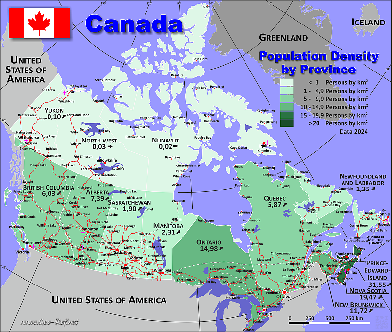
Country map - Administrative structure - Population density of Canada
Canada map - Click the map to get map as PDF file.
Other language versions are easy to generate, the descriptions are in own layers
Conditions for thematic maps with your own data and logotype
Delivery as printable file by e-mail or plot by post office
|
|---|
| Layers | |
| Provinces: | yes |
| Streets: | yes |
| Infrastructure: | yes |
| Rivers: | yes |
|
| Size | Till A2 |
| Delivery time | 7 working days | | Price |
| 1 bis 3 | 70 € | | > 3 | On request |
|
 |
All information published herein is free usable quoting the source,
including the maps, if they are not modified
|
|---|
Statistical data - Population density according to the administrative structure
The population data of the table below is an estimation form 2025, last available data.
Click on the column header brings the table in order of the column header.
The default order is the province name.
| Province |
ISO
3166-2 |
Capital |
Area
(km²) |
Population |
Density
(pers/km²) |
| Total |
|
|
9 930 202 |
41 651 653 |
4,19 |
|---|
| Last update:02/01/2021 - 14:16:56 |
|---|
| Alberta |
CA-AB |
Edmonton |
661 848 |
5 029 346 |
7,60 |
| British Columbia |
CA-BC |
Victoria |
944 735 |
5 697 536 |
6,03 |
| Manitoba |
CA-MB |
Winnipeg |
647 797 |
1 509 702 |
2,33 |
| New Brunswick |
CA-NB |
Fredericton |
72 908 |
869 682 |
11,93 |
| Newfoundland & Labrador |
CA-NL |
St John's |
405 212 |
549 911 |
1,36 |
| North West |
CA-NT |
Yellowknife |
1 346 106 |
45 950 |
0,03 |
| Nova Scotia |
CA-NS |
Halifax |
55 284 |
1 093 245 |
19,78 |
| Nunavut |
CA-NU |
Iqaluit |
2 038 722 |
41 830 |
0,02 |
| Ontario |
CA-ON |
Toronto |
1 076 395 |
16 258 260 |
15,10 |
| Prince Edward Island |
CA-PE |
Charlottetown |
5 660 |
182 657 |
32,27 |
| Quebec |
CA-QC |
Quebec City |
1 542 056 |
9 058 297 |
5,87 |
| Saskatchewan |
CA-SK |
Regina |
651 036 |
1 266 959 |
1,95 |
| Yukon |
CA-YT |
Whitehorse |
482 443 |
48 278 |
0,10 |
Existing thematic maps
|
External links change quickly - If you get a link error - Please inform us!
 |
Membership in international organisations and treaties
Expand list
Political Alliances
Regional Unions
Military alliances/Arms control
Law enforcement
Business Alliances
Fishery
Financial
Free Trade Area, Internal Market
Technical alliances
Environment
Transport
Cientific
Humanitarian Unions
Cultural Unions
|
|
If you have suggestions to include other information or you find missed links, please inform us!
Click here ... |
International Border disputes
Expand list
Land boundaries
Maritime boundaries
See also neighboring states
|
| |


