Sint Eustatius
| Capital |
Currency | Government system |
|---|
| Oranjestad |
Euro (EUR) |
Dependent from the Netherlands |
| Official language | Region |
Population |
|---|
| Dutch |
Central America & Caribbean |
2025 - 3 270 |
Country map - Administrative structure - Population density of Sint Eustatius
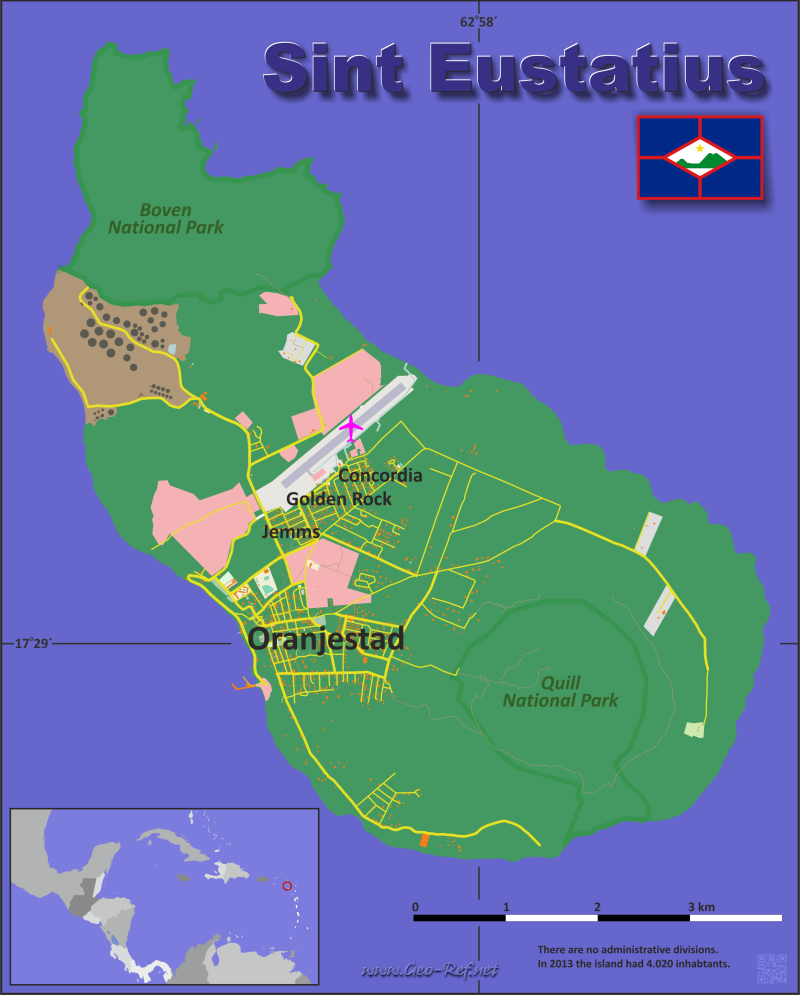
Sint Eustatius map - Click the map to get map as PDF file.
Other language versions are easy to generate, the descriptions are in own layers
Conditions for thematic maps with your own data and logotype
Delivery as printable file by e-mail or plot by post office
|
|---|
| Layers | |
| Provinces: | yes |
| Streets: | yes |
| Infrastructure: | yes |
| Rivers: | no |
|
| Size | Till A2 |
| Delivery time | 7 working days | | Price |
| 1 bis 3 | 50 € | | > 3 | On request |
|
 |
All information published herein is free usable quoting the source,
including the maps, if they are not modified
|
|---|
Statistical data - Population density according to the administrative structure
The population data of the table below is an estimation form 2020, based on the census 2018.
Click on the column header brings the table in order of the column header.
The default order is the parish name.
| Parish |
ISO
3166-2 |
Capital |
Area
(km²) |
Population |
Density
(pers/km²) |
| Total |
|
|
21 |
2 292 |
109,14 |
|---|
| Last update: 11/30/2025 - 10:50:56 |
|---|
| Bay Brown |
n.d. |
n.d. |
n.d. |
110 |
n.d. |
| Chapel Piece |
n.d. |
n.d. |
n.d. |
56 |
n.d. |
| Cherry Tree |
n.d. |
n.d. |
n.d. |
152 |
n.d. |
| Golden Rock/Concordia |
n.d. |
n.d. |
n.d. |
525 |
n.d. |
| Jeems |
n.d. |
n.d. |
n.d. |
118 |
n.d. |
| Mansion |
n.d. |
n.d. |
n.d. |
71 |
n.d. |
| Mountain |
n.d. |
n.d. |
n.d. |
47 |
n.d. |
| Oranjestad |
n.d. |
Oranjestad |
n.d. |
525 |
n.d. |
| Princess Garden |
n.d. |
n.d. |
n.d. |
153 |
n.d. |
| Wilton Farm/Union |
n.d. |
n.d. |
n.d. |
422 |
n.d. |
| _ nicht zugeordnet |
n.d. |
n.d. |
n.d. |
113 |
n.d. |
Existing thematic maps
|
External links change quickly - If you get a link error - Please inform us!
 |
Membership in international organisations and treaties
Expand list
Political Alliances
Regional Unions
|
|
If you have suggestions to include other information or you find missed links, please inform us!
Click here ... |
See also neighboring states
|


